Another disturbance moving through Manitoba mid-week will bring another swath of accumulating snow to the region. Behind it, bitterly cold Arctic air will sweep into southern Manitoba.
For today, a weak ridge of high pressure moving through the region will bring near-seasonal highs in the mid-minus teens to the Winnipeg area. Light southerly winds will pick up to around 20 km/h in the afternoon, bringing wind chill values of -20 to -30 to the region.
The next weather system of note will begin to push into the region tonight. Cloud cover will spread across southern Manitoba as it pushes a warmer air mass into the region. Light snow will spread across southwest Manitoba overnight and begin to push into the Red River Valley early Wednesday morning. Temperatures will dip into the -15 to -20 °C range in the evening and then warm up closer to -10 °C by Wednesday morning.
2 to 5 cm of new snow is likely through much of western Manitoba tonight.
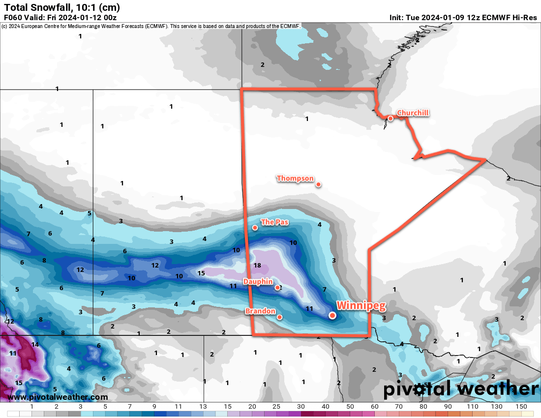
On Wednesday, the low pressure system will drop to the southeast with an inverted trough that lingers to the northwest in its wake. This will support a slow-moving area of light snow that lingers over the Red River Valley through Wednesday and into Thursday. Accumulation rates will be light, but because the snow will linger for a long time, it will result in one of the larger snowfalls of the season.
From Wednesday morning to Thursday morning, 5 to 10 cm of new snow is likely in the Red River Valley, but that number increases into the 10 to 20 cm range to the northwest in parts of Western Manitoba, focused around the escarpment west of Lake Manitoba and Winnipegosis.
Temperatures will reach a high near -7 °C in Winnipeg on Wednesday, but a cold front will sweep through on Thursday night and mark the beginning of plummeting temperatures.
The snow will taper off later Thursday as northwest winds increase into the 20 to 30 km/h range. Temperatures will fall through the day, reaching close to -20 °C by evening. The cloud cover will begin to break up overnight as temperatures head to a low in the -20 to -25 °C range.
On Friday, the cold air will settle into the region as a large Arctic High begins to push across the Prairies. Winnipeg’s temperatures will climb back into the -20 to -15 °C range with northerly winds hovering around 20 km/h. Skies will likely be on the cloudier side as a glancing disturbance spreads more cloud cover across the southern Prairies.
That cloud will prevent temperatures from dropping too much on Friday night with lows back to around -25 °C.
Long Range Outlook
The Arctic High will continue to slump eastwards across the Prairies this weekend, eventually clearing skies. Temperatures will plummet into the -20s this weekend with a chance of overnight lows dipping to around the -30 °C mark.
The region could end up contending with wind chills below -35 on the weekend.
A push of warmer temperatures will move through the Prairies early next week, but guidance suggests that it will occlude southwards well before it reaches Manitoba. A small moderation in temperatures is possible early in the week, followed by another push of colder temperatures.
Little accumulating snow is in the forecast for next week, but flurries will be possible across several days.
Today’s seasonal daytime high in Winnipeg is -13 °C while the seasonal overnight low is -24 °C.