Cool With Light Snow Mid-Week

Arctic air will continue to build southward over the eastern Prairies in the coming days, bringing below-seasonal temperatures, variable cloudiness, and on Wednesday, some light snow.

Cloud will build into Winnipeg from the northwest later today as a cold front slumps southwards out of northern Manitoba, possibly bringing the occasional snowflake, but nothing that resembles accumulating snow. Temperatures remain cool with a high near -6°C, almost 9°C below seasonal for this time of year. Winds will continue out of the west at around 15 to 20 km/h through the day today. Skies should clear out overnight as temperatures head to a chilly low near -17°C. Winds will remain out of the west at 10 to 15 km/h.

Tuesday will see morning sun transition to mixed skies as another disturbance approaches from the northern Prairies. Temperatures will be similar to Monday with highs near -6°C again, but Tuesday night will be considerably warmer with lows near -9°C courtesy overcast skies that will move into the region. Winds will shift from west to northwest on Tuesday night, setting the stage for cooler air to move in on Wednesday.

Some light snow is expected across much of southern Manitoba on Wednesday

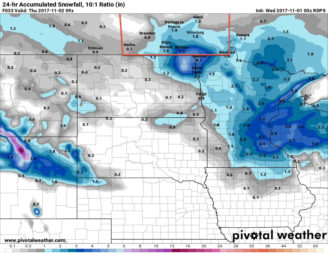
Expect cloudy skies on Wednesday with some light snow and a cool high near -8C. Those northwesterly winds will likely fire up the lake-effect snow once again, enhancing the flurries to the south of Lake Manitoba and Lake Winnipeg.

Expect the clouds to persist much of Wednesday night with temperatures dropping to a low near -16°C.

Long Range Outlook

The remainder of the week will continue to bring mixed skies with the occasional chance for flurries. By Saturday, temperatures should begin to climb back towards the freezing mark, with near-seasonal temperatures expected to start next week!

Winnipeg’s seasonal daytime high is currently 1°C while the seasonal overnight low is -7°C.

Forecast Update: Snowy Saturday Ahead

Environment Canada has issued a heavy snowfall warning for Winnipeg:

Southern Manitoba Wnaring Map – 4:00PM Friday November 3, 2017
Environment and Climate Change Canada has issued a snowfall warning for all of Southern Manitoba

Snowfall, with total amounts of 10 to 15 cm is expected.

Moderate to heavy snow will spread into southern Manitoba Friday night into Saturday morning. Approximately 10 to 15 centimetres is expected by the time snow begins to ease Saturday evening, with locally higher amounts where terrain features may enhance snowfall intensity.

Be prepared to adjust your driving with changing road conditions. Prepare for quickly changing and deteriorating travel conditions. Rapidly accumulating snow could make travel difficult over some locations. Visibility may be suddenly reduced at times in heavy snow. If visibility is reduced while driving, slow down, watch for tail lights ahead, and be prepared to stop.

Please continue to monitor alerts and forecasts issued by Environment Canada. To report severe weather, send an e-mail to ec.storm.ec@canada.ca or tweet reports using #MBstorm.

As we mentioned in our forecast this morning, this system has been one that forecast models have had a trouble getting a handle on, however this morning’s 12Z runs have moved towards a consensus (save for the GFS, which seems like a bit of a southern-biased outlier for Saskatchewan).

That said, it looks very likely that not only Winnipeg, but the entirety of southern Manitoba will see a blanket of snow tomorrow as this incoming system produces 10 to 15 cm of snow in most places. Some areas, like the far southwest corner, may end up just hitting the 10 cm mark, while upslope-enhanced areas such as the Riding Mountains may see closer to 15 to 25 cm of snow.

The RDPS shows a wide swath of 10 to 13 cm of snow by Saturday evening

With daytime highs near 0°C in Winnipeg, it will also likely be a fairly heavy snow — good for snowmen! – and by the time all is said and done, it’s likely that there is around 10 to 13 cm of new snow on non-road surfaces. Assuming the roads are treated properly, expect a slushy mess that freezes on Saturday night into Sunday.

Highway conditions will likely deteriorate fairly quickly Saturday morning as well, so if you need to travel be sure to give yourself extra time, drive safely, and carry an emergency car kit.

The snow will taper off on Saturday evening, followed by gusty westerly winds developing overnight into Sunday morning. These breezy winds of around 30 gusting to 50 km/hmay produce local areas of blowing snow, so again drive with care.

You can refer back to our Friday morning forecast for details on the remainder of the weekend.

After A Failed First Attempt, Winter Arrives Saturday

Winnipeg may have managed to dodge the snow on Wednesday, but another disturbance moving through Saturday will blanket the city in snow, then be followed up by the first winter-like cold snap of the season.

Today will be a fairly benign day in Winnipeg as the disturbance that will bring snow to the region tomorrow develops over Montana and Saskatchewan. Before that arrives, the region will see a mix of sun and cloud with temperatures climbing back to a high near -2°C and light winds.

Clouds thicken up tonight as the inverted trough1 that will bring snow to the region advances across Saskatchewan. Expect temperatures to dip to a low near -5°C early before climbing back towards around -3°C by morning with winds picking up out of the east to around 20 km/h. Some light snow may move into the Red River Valley late overnight, but if this system ends up a bit slower then the snow may hold off until Saturday morning.

NAM Forecast Precipitation valid 12Z Saturday November 4 to 06Z Sunday November 5, 2017
Moderate snow will spread into the Red River Valley Saturday morning and persist through the day

Saturday will bring snow to much of southern Manitoba as an inverted trough moves across the province. The snow will spread from southwest of northeast through the day, with the heaviest snow in the Red River Valley expected midday into the afternoon. The snow will taper off from west to east, beginning in the late afternoon over the southwest, then through the evening in the Red River Valley, and after midnight in the southeast. Between 5 and 10 cm of snow will likely accumulate across much of southern Manitoba, with the chance for localized pockets of slightly higher amounts, by the time the snow tapers off.2

RDPS Forecast 2m Temperature valid 00Z Sunday November 5, 2017
Temperatures will climb to or just above the freezing mark across muhc of south-central and southeastern Manitoba on Saturday afternoon

Aside from the snow, Saturday will bring more mild temperatures to Winnipeg with highs climbing to or just above 0°C. Winds will gradually ease through the day, but then pick up to 20 to 30 km/h out of the northwest overnight, making some blowing snow possible in open areas. Temperatures will dip down to a low near -4°C on Saturday night.

Sunday will bring mainly cloudy skies to Winnipeg, but temperatures will barely recover from the overnight low, reaching a high of just -2 or -3°C as northwesterly winds usher cooler air into the region ahead of an approaching Arctic high. Sunday night will be quite cool with lows sinking to near -13°C as skies clear out.

Long Range Outlook

In the wake of Saturday’s disturbance, cooler temperatures will flood into the Prairies as a persistent northwesterly flow aloft taps into Arctic air. Temperatures will remain well below-normal for much of next week, save for a brief reprieve in the latter half of the week when another low pressure system moves through, but then the cold temperatures surge back into the region. So bundle up and get your winter clothes out, you’ll be needing them!

Winnipeg’s seasonal daytime high is currently 3°C while the seasonal overnight low is -6°C.

  1. An inverted trough is a trough of low pressure that extends northwards from a low pressure system.
  2. While model agreement is increasing, there’s still a fair amount of uncertainty with this system and we may update our snowfall forecast later today if needed.

Cool and Snowy Start to November

November will be off to a snowy start as a clipper system tracking across North Dakota spreads snow across southern Manitoba today. In the wake of this low, an Arctic ridge will build into the Prairies and bring unseasonably cool temperatures to the region.

Light snow is on the way for Winnipeg today as snow spreads through the Red River Valley, supported by a low pressure system tracking across North Dakota. The snow will begin early this morning and persist throughout the day before tapering off later this evening. By the time snow tapers off, this system will produce generally 5-10 cm of snow along and south of the Trans-Canada Highway corridor with highest amounts near the US border decreasing northwards. The fly in the ointment, as it were, will once again be temperatures that climb up to or just above the freezing mark. The mild conditions will result in quite a bit of snow melt, however it’s likely that a few centimetres accumulate by the end of the day. That said, it won’t quite be the widespread blanketing that it would be if things were even a couple degrees cooler.

RDPS Forecast 24hr. Accumulated Snowfall w/10:1 SLR valid 09Z Thursday November 2, 2017
This system will produce 5-10cm of snow over the Red River Valley, however mild temperatures will reduce the amount of snow that actually accumulates

Aside from the snowfall, it will be a relatively pleasant day. Temperatures will climb to a high near +1°C with winds out of the east-northeast at 20 to 30 km/h. Heading into the evening, the winds will shift to the north at around 30 km/h with snow tapering off as temperatures dip to a low near -2°C under mostly cloudy skies.

Thursday will bring mostly cloudy skies to Winnipeg and area, although a few sunny breaks are possible. Temperatures will recover just barely to -1°C as a breezy northerly wind continues, marking the gradual approach of a large Arctic-sourced high pressure system. The cloud cover will break up in the evening as winds drop off, which will send temperatures plummeting to a low near -10°C as colder Arctic-sourced air arrives.

GDPS Forecast 850mb Temperature Anomaly valid 06Z Friday November 3, 2017
This forecast of 850mb temperature anomalies shows the much cooler than seasonal air mass that will be in place over Southern Manitoba on Thursday night

Winnipeg will see mixed skies on Friday with temperatures climbing back to around -3°C with light winds. Expect the cloud cover to thicken back up on Friday night in advance of the next system that will move through this weekend as lows dip down to into the -7 to -10°C before beginning to moderate towards Saturday morning.

Long Range Outlook

Saturday and Sunday will both be largely influenced by a major low pressure system tracking across the Prairies. A warm front will push through on Saturday, bringing rain and snow to the region as temperatures climb just above freezing again. There will likely be a break in the precipitation, but then a cold front will sweep through Saturday night into Sunday, bringing more snow and breezy northwesterlies as temperatures plunge well below seasonal.

NAEFS 8-14 Day Temperature Anomaly Forecast — Valid November 8-15, 2017

Next week looks very cold as the jet stream plunges south, allowing Arctic air to spill southwards across the Prairies. If you haven’t already, it’s probably time to get the winter jacket and gloves out!

Winnipeg’s seasonal daytime high is currently 4°C while the seasonal overnight low is -5°C.