Bitterly Cold Weekend; Warmer Weather Next Week

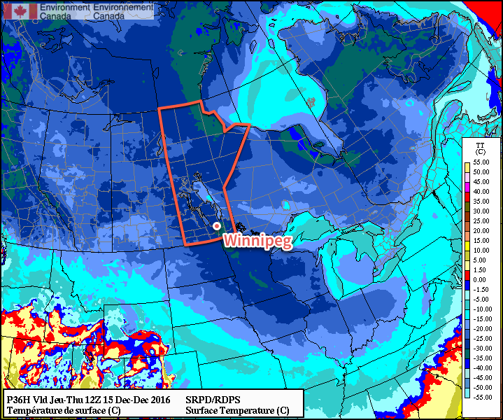
The coldest temperatures of the winter are on their way to southern Manitoba as a reinforcing blast of Arctic air descends from the north. The cold snap will persist into the start of next week, but milder air is expected to arrive by Tuesday or Wednesday.

The next few days will be very quiet weather-wise other than the fact that bone-chilling cold is moving into the province. Winds for the next few days will be between 10-20 km/h out of the northwest slowly backing to southerlies by Sunday. Skies will be mainly sunny through the weekend.

Bitterly cold air will descend into Southern Manitoba this weekend.

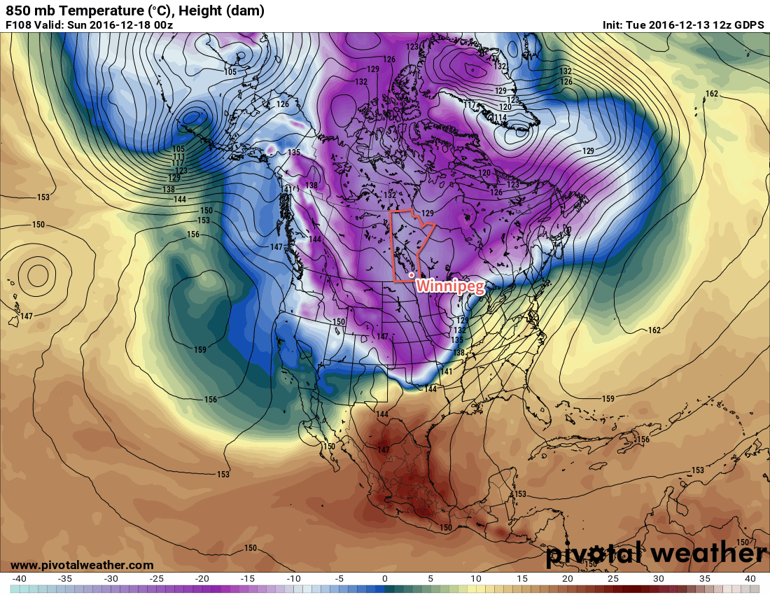
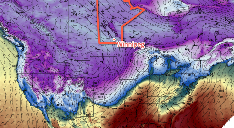
The big story is the cold, shown above with the 850mb1 temperatures. The potency of this Arctic outbreak is highlighted by temperatures at this height reaching -30°C, a sign of a truly cold air mass.

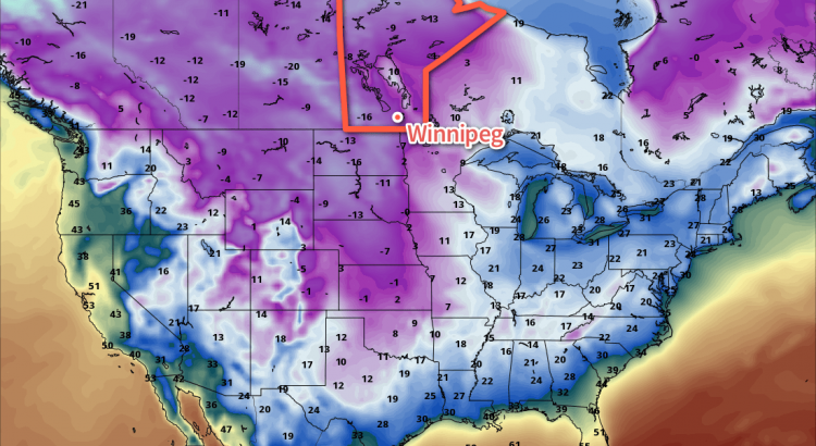
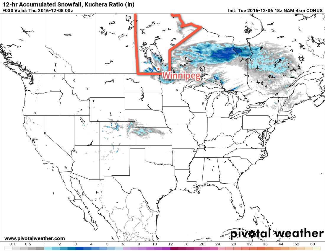
This will result in temperatures dropping from a high near -21°C today to a low just below the -30°C mark. Temperatures will struggle to recover to the mid-minus 20's on Saturday before dipping to a low near -32°C on Saturday night. Sunday will see warmer air aloft working into the region, allowing temperatures to moderate towards around -22°C by late in the afternoon. Some cloud cover will begin working in through the afternoon and cloudy skies on Sunday night will bring the chance for some light snow with temperatures hovering around -23°C.

Wind Chill

Wind chill values will be a concern this weekend, likely reaching Environment Canada's warning criteria of -40. Winds slightly over 10 km/h both Friday and Saturday night will combine with low temperatures dipping below -30°C to produce wind chill values in the -39 to -44 range. Wind chills of this severity can result in frost bite on exposed skin in 5-10 minutes, so be sure to take precautions and layer well if you need to be outside at night.

As an aside, it's worth reminding people that wind chill is not a temperature. Wind chill describes what the temperature would have to be with no wind to lose body heat at the same rate as the actual temperature with wind. So wind chill of -40 produced by a night with temperatures of -29°C and a 15 km/h wind describes that the rate of heat loss in the actual conditions is the same as if it was -40°C outside with no wind.

Wind chill has numerous problems, but does serve as an imperfect method of communicating a very real thing.

But just keep in mind that it is not a temperature, but an expression of a rate of heat loss.

If you want to know more about wind chill, visit our article "The Problem With Wind Chill"

Long Range

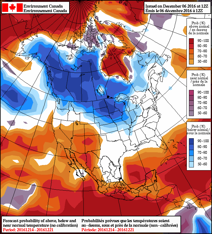
Early next week will bring milder air back to the region. By mid-week, highs should be back into the -10°C to -5°C range. Before that warm air arrives, though, it's quite possible we'll see quite unpleasant conditions with moderate southerly winds making it feel much colder than the temperature would imply. That said, there's high confidence that the warm air will get here by mid-week, so if you can make it through this cold snap, more pleasant conditions await on the other side.

Winnipeg’s seasonal daytime high is currently -10°C while the seasonal overnight low is -20°C.

  1. This height is approximately 1.5km above sea level.

Cold Becoming Colder

Those looking for a reprieve from the cold will have to wait longer. Temperatures are set to remain cold throughout the week with even colder air set to move into the region for the weekend.

Today will bring a little sun and a little cloud to the region with temperatures climbing to a high near -18°C. There will be a slight chance of some light flurries, particularly in the afternoon and evening, but it won't amount to anything substantial. Skies will be clear tonight with temperatures plummeting to a low near -29°C as another surge of Arctic air pushes southwards behind a cold front that passed through late Tuesday evening. It doesn't look like we'll crack -30°C at this point, but we'll likely be flirting with the value.

Thursday will bring sunny skies and cold temperatures as a ridge of high pressure settles over the region. With a high of just -21 or -22°C, Winnipeg will be nearly 8°C below normal for this time of year. Thursday night won't be as cold, however, as "milder" air from the Yukon spreads southwards and eastwards into the region. The overnight low should be around -24 or -25°C on Friday morning.

The RDPS is suggesting temperatures may fall below -30°C early Thursday morning, but other models suggest slightly warmer temperatures.

Friday will see a return to highs above the -20°C mark with temperatures climbing to -18°C or so. Skies will be fairly cloudy as that weak disturbance carrying the Yukon "warmth" moves through, and there will be a slight chance of some light flurries through the day. Again, nothing particularly notable with just a dusting of snow possible. Temperatures will drop to around -26°C on Friday night under mixed to cloudy skies.

Long Range

The weekend is looking fairly brutal as another cold front moves through on Friday and ushers another, more powerful shot of Arctic air into Southern Manitoba.

An outbreak of bitterly cold Arctic air is expected this weekend.

This winter blast will push all the way south into Oklahoma, ensuring that the entire eastern half of the Canadian Prairies is entrenched in bitterly cold air. At this point, it seems quite likely temperatures will fall below -30°C on Saturday night alongside a good chance of widespread extreme cold warnings from Environment Canada.

The light at the end of the tunnel, though, is that warmer air is forecast to arrive next week as a powerful surge of Pacific air sweeps eastwards across the Prairies, sending highs back up into the minus single digits. There's a lot of uncertainty at this point, and I think that models are generally warming Winnipeg up too quickly with the cold weather likely hanging on an extra day with very windy conditions out of the south before the mild air actually arrives.

It seems quite likely that more seasonal to slightly above seasonal temperatures will be in place for the week leading up to Christmas.

Winnipeg’s seasonal daytime high is currently -10°C while the seasonal overnight low is -20°C.

Here Comes The Deep Freeze

Now that the cleanup is underway after a brutal snowstorm that dumped over a foot of snow across many places in Southern Manitoba and produced white-out conditions that closed a majority of major highways across the region, cold Arctic air will spread southeastwards across the Prairies, bringing below-seasonal temperatures for the first time since mid-October.

Today will be a shockingly cold day with daytime highs of just -17°C as a ridge of Arctic high pressure builds into the region. Skies will be partly cloudy with light winds out of the west to northwest. There will be a slight chance of flurries as light lake-effect snow continues off of Lake Manitoba. Tonight will be very cold with mostly clear skies and a low near -26°C.

This impressively strong Arctic outbreak will send sub-freezing temperatures (blue) all the way to the Gulf of Mexico states.

This weekend will be cold. Saturday will see a high of just -18°C and a low near -25°C. There will be some cloud cover that works its way into the region in the afternoon as a disturbance slides through South Dakota, but other than a chance for some flurries near the US border, shouldn’t cause much weather for us.

Sunday will be a bit of a mixed bag with a few clouds likely in the morning, then some clearing, then increasing cloud as the next system that will affect us approaches. Temperatures will be a bit milder with highs near -16°C, but with winds picking up out of the south to 20-30 km/h, it will feel closer to -25. Sunday night will bring cloudy skies with an increasing chance of snow as temperatures drop just a couple degrees to a low near -18°C.

Long Range

Sunday night’s disturbance will bring a chance for flurries to Southern Manitoba alongside a shot of slightly-below seasonal temperatures, but on the back-side of it another shot of Arctic air will blast southeastwards and plunge temperatures back into the -20’s. Will we see our first -30°C low next week? Time will tell.

Winnipeg’s seasonal daytime high is currently -9°C while the seasonal overnight low is -18°C.

Flurries Mark Descent Into an Arctic Chill

A powerful winter storm brought 20-30cm of snow to much of the Red River Valley yesterday followed by another 4-8cm overnight. This fresh snow combined with powerful northerly winds to produce white-out conditions on area highways. The snowfall accumulations combined with the blowing snow resulted in the closure of many area highways making travel nearly impossible. While conditions will gradually improve, it will be at the cost of the warmth that’s been in place over the region for the past month: the coldest temperatures we’ve seen since February are on the way.

This map from 8:20PM yesterday shows the extensive road closures (red) across Southern Manitoba.
Wednesday
-4°C / -10°C
Flurries with blowing snow

Today will bring flurries to the region as a weak disturbance slides through from the northwest on the backside of the main low pressure system that brought the heavy dump of snow yesterday. The gusty northerly winds will continue with winds out of the north to northwest at 40 gusting 60 km/h. While the snow won’t be nearly as heavy as yesterday, most places can still expect another 2-4 cm of snow.

The one exception to that will be areas in the lee of Lake Manitoba, where a band of lake-effect snow is expected to develop which will move south-southeast off the lake. This will result in a narrow band of snow which could see accumulations potentially reach as high as another 15-20cm, depending on how intense the flurries become.

The 4km NAM model shows a narrow band of enhanced snowfall today in the lee of Lake Manitoba, passing just west and south of Winnipeg.

Snow will taper off this evening, save for lingering snow moving off the lakes. Skies will remain mainly cloudy as temperatures head towards a low near -10°C with winds easing to 30 gusting 50 km/h by Thursday morning.

Thursday
↓ -14°C / -21°C
Cloudy with a chance of flurries

Thursday will continue with mainly cloudy skies and a chance of flurries, but winds will slowly ease to around 20 km/h. Temperatures will remain steady through the morning, but then drop towards the -14°C mark through the afternoon. Skies will begin to clear through the evening, save for a narrow band of cloud coming off each of Lake Manitoba and Lake Winnipeg. There’s a fairly decent chance that Winnipeg will see some flurries from Lake Manitoba on Thursday night as winds shift to more of a WNW direction. Temperatures will drop to a low near -21°C, but may remain a few degrees warmer underneath the lake-effect cloud cover. Wind chill values will be in the -30 to -35 range overnight.

Friday
-17°C / -24°C
Partly cloudy

Much of the cloud cover will break up on Friday with winds dropping off as the Arctic ridge begins moving into the province. While there will be some sun, temperatures will be well below seasonal values with highs near the -17°C mark. Temperatures will dip to a low near -24°C on Friday night.

Long Range

The cold weather will last through the weekend and into the start of next week; Saturday and Sunday will likely see highs in the -15 to -20°C range with the chance of flurries as a disturbance moves through. Even colder air has the potential of building in for the start of next week, potentially pushing daytime highs below -20°C.

NAEFS 8-14 Day Temperature Anomaly Forecast — Valid December 14 to 21, 2016
In general for the first half of December, below-normal temperatures are expected as an air mass that had previously been locked over Siberia has shifted across the Arctic and will remain entrenched over the northern sections of North America.

Winnipeg’s seasonal daytime high is currently -8°C while the seasonal overnight low is -18°C.