A Seasonal Christmas Ahead; Cold This Weekend

Light snow will taper off and lead towards a seasonal Christmas this year with a chance of flurries, but perhaps one of the strongest shots of cold air seen this winter will move in for Boxing Day.

Light snow will persist through much of today thanks to a persistent area of snow hanging back into the Red River Valley. There will be a bit more accumulation; generally around 2-4 cm will fall today through the valley. The wind will be a bit chilly as it picks up out of the northwest to around 30 km/h with some gusts on top of that; with the fresh snow in place, it will likely be enough to produce localized areas of blowing snow and poor visibilities. With that north wind, we’ll see temperatures fall throughout the day to around -10°C by the evening hours, which will be just a couple degrees warmer than our overnight low of -12°C.

Thursday will see plenty of cloud lingering around in the Red River Valley. Temperatures will be nearly stagnant through the day, rising just a couple degrees by early in the afternoon before beginning to fall again, a casualty of the incoming Arctic air. It doesn’t look like snow will be much of an issue, though, so other than the cool temperatures, the day should actually be alright. Heading into the night, temperatures will drop to around -15°C under mostly cloudy skies.

GDPS forecast surface temperatures for Friday at 18Z
GDPS forecast surface temperatures for midday Friday

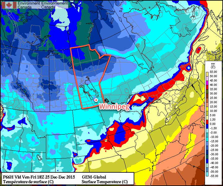
Friday, Christmas Day, will be a seasonal day thanks to a weak disturbance forecast to slip across the region, delaying the arrival of the colder Arctic air. With a daytime high of -12°C, temperatures will be nearly right on what’s seasonal for this time of year. A bit of very light snow is likely, but accumulations look to be minimal. Winds will shift around to the north and begin ushering in colder air late in the day. Expect an overnight low on Friday night dipping into the -20’s, likely around -22°C or so with clear skies beginning to develop over the region.

Long Range

The weekend will start with a miniature deep freeze, at least by the standards 2015 has set so far. Saturday will see clear skies and daytime highs struggling to climb even towards the mid-minus teens, likely ending up somewhere between -20 and -15°C. Fortunately, the cold weather will be short lived with a surge milder air returning for Sunday and returning daytime highs close to the -10°C range.

NAEFS 8-14 Day Temperature Anomaly Forecast valid December 31, 2015 to January 7, 2016

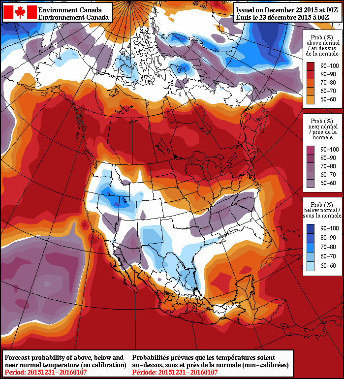
Heading into the longer-range, there’s very strong agreement that a return to significantly above normal temperatures will return to the region for the new year. The NAEFS is actually forecasting a significant stretch of daytime highs likely in the -10°C to -5°C range for the first week of January. So just get past this weekend and rest easy knowing that relative warmth is on the way!

The seasonal temperatures for Winnipeg right now are daytime highs of -12°C and overnight lows of -22°C.

Seasonal Weather with a Bit of Snow

Calmer weather is settling into Southern Manitoba after a Colorado Low dumped 10–20cm of snow over the Red River Valley, quickly turning an area that still had substantial amounts of snow-free ground into a winter wonderland.

Today will bring mixed skies to Winnipeg & the Red River Valley as cloud left behind from this week’s storm straggles over the region. Temperatures will be much closer to seasonal than we’ve experienced over the last several weeks. Today’s high temperature will be around –13°C, actually a couple degrees below the seasonal high temperature of –11°C. With some clear patches working their way into the Red River Valley this evening, the overnight low will manage to drop all the way down to a seasonal –20 or –21°C.

RDPS Precipitation Forecast valid 18-06Z December 19/20, 2015
The RDPS shows a swath of snow pushing across Southern Manitoba late Saturday

Saturday will see more cloud spreading into Southern Manitoba as a mid-level disturbance tracks along the international border. As the system approaches, an area of light snow will spread across the region. Total snowfall is expected to be light, with just 1–2cm over the Red River Valley. Further north through the Interlake could see a tad more snow with total amounts in the 2–4cm range. Temperatures will remain cool with daytime highs near –12°C. Winds will be a bit breezy out of the southeast at 20–30km/h.

The extensive cloud cover at night will moderate the overnight low, with temperatures dropping to just –14 or –15°C. The winds will diminish early in the evening.

Sunday will continue with mixed skies, but temperatures will be quite a bit warmer than Friday or Saturday as daytime highs climb towards –8°C with light northwesterly winds. Not much else to talk about for the end of the weekend as skies clear and temperatures dip back into the mid-minus teens on Sunday night.

Looking Ahead to Christmas Week

Next week is looking great considering we’re moving into the second half of December. The northwesterly flow aloft which is giving us this outbreak of more seasonal temperatures is forecast to be replaced by a more zonal (west-to-east) or southwesterly flow aloft, which will help milder air spread over the southern Prairies.

We may see a few bouts of light snow next week while we enjoy warmer-than-seasonal temperatures in the –5 to –10°C range.

First Major Snowstorm of the Winter Incoming

Southern Manitoba has its first major snowstorm of Winter 2015/16 on the doorstep as a Colorado Low moves northeastwards through the American Plains and is poised to produce 10–20 cm of fresh snow through the Red River Valley.

The incoming Colorado Low has spread snow across South Dakota this evening which is now pushing into North Dakota and Minnesota. This area of snow will intensify as it heads northwards courtesy a steadily organizing weather feature called an inverted trough. This trough of low pressure extends north/northwest out from the centre of the Colorado Low and will draw moisture into the Red River Valley and produce a swath of heavier snow through the region.

Mayville RADAR @ 10:29PM CST on December 15, 2015
At 10:29PM CST, Mayville RADAR in North Dakota shows a broad area of snow pushing northwards towards Manitoba.

At this point, it looks like the snow will begin pushing across the U.S. border sometime between 2 and 4 A.M. and then spread into Winnipeg before 4 and 6 A.M.. The heavier snow will build into the Red River Valley between 6 and 9 A.M. and persist until near lunch time. Through the first half of the day, as much as 10 cm could fall; that’s a fairly intense snowfall rate and will undoubtedly have significant impacts on transportation. The snow will ease slightly for the afternoon, but still be fairly persistent, dropping another 2–5cm or so.

Winnipeg Forecast Sounding for 11Z December 16, 2015
The forecast soundings for Winnipeg on Wednesday morning show very favourable thermodynamic profiles for moderate to heavy snow.

Heading into the evening and overnight hours, the snow will begin to become a little bit more disorganized save for one area known as the deformation zone. This feature will be the western-most extent of the snowfall and will typically have slightly more organized precipitation along it. Best indications at this point are that the deformation zone will line up through the Interlake and Red River Valley, meaning it’s fairly likely that more persistent light snow will last through the night. This snow could produce anywhere from 1–3cm more.

AWM Snowfall Outlook for December 15-17, 2015
AWM Snowfall Outlook for December 15-17, 2015 with verification overlaid.

By Thursday morning, the snow should be tapering off to flurries and moving out of the region. When all is said and done, it’s likely that anywhere from 10 to 20cm of fresh snow will have fallen in the Red River Valley. Localized amounts could possibly exceed 20cm in a few particular locations, namely anywhere that may see upslope enhancement in the northerly winds: the western escarpment of the Red River Valley and north side of Turtle Mountain being to of the most likely places. These higher amounts would be very localized, though, and are not reflected in the above snowfall forecast, which is looking more at large-scale snowfall totals.

Snowfall Warning Highlights
The highlights of this Colorado Low storm system

Environment Canada has issued a snowfall warning arcing across the Red River Valley with the discussion showing very similar thinking: 10–20cm of snow, heavy first thing Wednesday morning, then blowing snow and cooler temperatures heading into Thursday.

Cooler with Blowing Snow Behind the Colorado Low

Beginning Wednesday evening, northwesterly winds will begin moving into southern Manitoba. Despite the cooler temperatures pushing in and the relatively strong winds aloft, winds will likely only reach around 30 gusting to 50 km/h overnight.[1]

By Thursday morning, the wind will strengthen to 40 gusting 60 km/h, which when combined with the fresh snow, will almost undoubtedly produce fairly widespread blowing snow through the Red River Valley. These stronger northwesterly winds will also be ushering in a much cooler air mass that will drop temperatures to –20°C by Saturday morning.

This colder weather, while an abrupt change from what we’ve been seeing for the past month and a half, is actually not all that uncommon. Normal daytime highs for Winnipeg this time of year are around –10°C with normal overnight lows near –20°C. So while we’ll see temperatures dropping 10–15°C, they’ll be seasonal to just slightly below seasonal for this time of year.

Fortunately this cold snap will be brief. Early next week it looks like a weak system will move through bringing a chance for some light snow and a return to slightly above-seasonal temperatures.


  1. This is due to the cyclonic curvature of the surface pressure gradient which can act to diminish wind speeds.  ↩

Cooler, But Still Mild for December

Slightly cooler temperatures have moved into the Red River Valley, but they won’t be enough to break our trend of unseasonably warm weather as daytime highs and lows continue to sit between 5 to 10°C above normal. Alongside the cooler but still relatively mild weather will be a whole lot of cloud and a chance for some more snow across the region.

Today’s weather will be predominantly influenced by a ridge of high pressure extending from the high Arctic southwards through Nunavut, Manitoba and into North Dakota. Unlike some Arctic ridges, this one is fairly weak, and as a result, instead of crisp blue skies and bone-chilling cold, we’ll see grey skies, cool easterly winds, and a slight chance of flurries.

With all the cloud cover entrenched over the region, temperatures today will be fairly mild. Daytime highs through the Red River Valley should end up sitting around –1°C.

Another shot of light snow is in the cards for tonight, however, as a band of snow slowly spreads northeastwards out of the United States. The snow will develop and through the day on the U.S. side of the border as a low pressure system, ejected eastwards from yesterday’s explosive Pacific-coast storm, develops through the Northern Plains. The band of snow will slowly push to the northeast and move into southern Manitoba through the overnight period. For most places, less than 1–2cm is expected, however near the U.S. border, slightly more may fall, totalling up to 2–4cm by Saturday morning. Expect an overnight low near –5°C.

RDPS 12hr. QPF valid 12Z December 12, 2015
The RDPS is forecasting light snow across much of the Southern Prairies on Saturday night.

Saturday will bring more cloudy skies and widespread light flurry activity. Temperatures will continue to be mild with daytime highs around –2 or –1°C, which when combined with the fact that there won’t be much wind to speak of, will make for quite a pleasant December day. The flurries will taper off in the evening as temperatures dip just a few degrees to about –5°C.

Mild weather continues on Sunday under cloudy skies as slightly warmer air builds into the southern portion of the province. Daytime highs will climb 1–2°C higher than Saturday and sit near the freezing mark with relatively light northeasterly winds. No organized snow is expected on Sunday, so all in all, it will likely be a pleasant end to the weekend! Expect temperatures to dip to around –5 to –7°C on Sunday night.

Long Range: Does the Warmth End?

This section of the forecast has been a broken record so far this winter: continuing mild. And, at the moment, that’s not going to change. In fact, over the past week and a bit, several agencies have re-run seasonal forecast models for North America and they all continue to forecast the same thing: generally mild weather with below-normal precipitation.

NAEFS 8-14 Day Temperature Anomaly Forecast
As has been the almost-permanent state of the NAEFS this winter, above normal temperatures are forecast in the 8-14 day range for Manitoba

This large-scale seasonal outlook has been faring quite well so far this year. The end to this year has been exceptionally mild for Winnipeg; perhaps not in magnitude[1], but just through the sheer persistence of moderately above-normal temperatures.

Climate Prediction Center's 90-Day Temperature Trace for Winnipeag
The CPC’s 90-day temperature trace for Winnipeg

Since the beginning of November, there have been just 4 days with below-normal daily temperatures and over the last 90 days, just 16. In a place that’s known for large temperature ranges, it’s impressive to think that over 80% of the past 90 days have been unseasonably warm. This incredible warmth led to the 4th warmest fall on record with a mean temperature 3.0°C above normal. By all accounts, this trend looks to continue and that the remainder of the winter, although likely to have occasional cold spells, will generally be a mild one.


  1. Record high temperatures have been relatively rare over the past 60 days.  ↩