Weather Forecasts, Facts and News for Winnipeg & Southern Manitoba
Author: Brad
Brad lives in Winnipeg with his wife and two children and is the founder of A Weather Moment. He has loved weather from a very young age and has followed that passion through his life so far. He received a B.Sc. in Earth Sciences with Specialization in Atmospheric Sciences and is currently employed in the field of meteorology. You can find the author as WeatherInThePeg on Mastodon.
Winnipeg is finally seeing a break from the relentless heat and humidity of the past week thanks to the passage of a cold front yesterday evening that pushed the humid air mass that had been so persistent over our region off to the east and ushered in significantly drier air from the western Prairies. Conditions will remain fairly unsettled over the next few days, however, as multiple shortwaves slide down over the province in the northwest flow left in the wake of a departing low pressure system.
Wednesday
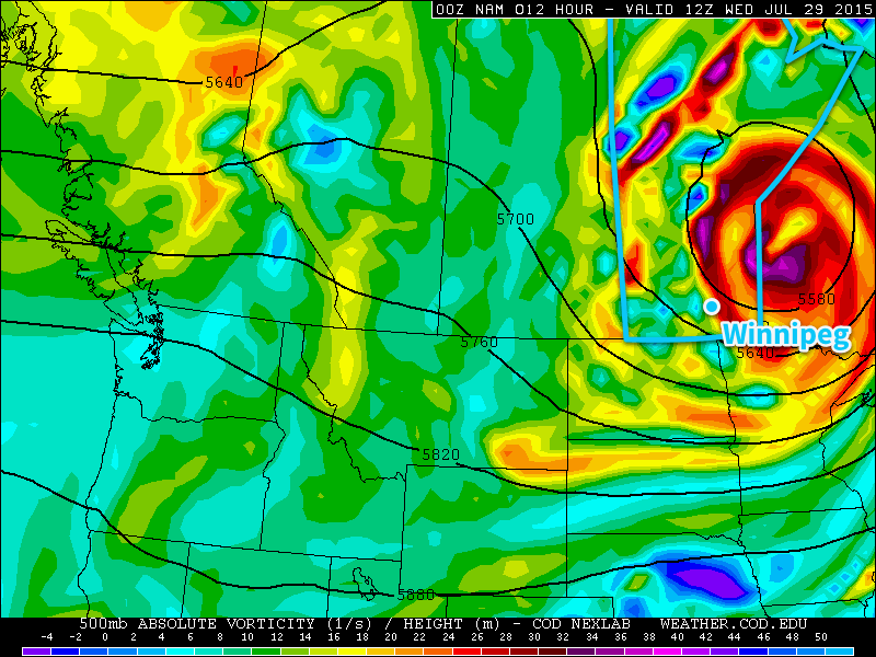
Today will be a fairly cloudy day as the upper low associated with the system that brought a terrifying long-tracked, rain-wrapped, nocturnal, multi-vortex tornado to southwestern Manitoba moves over the region.
This morning’s forecast 500mb vorticity from the NAM shows the intense upper-level low departing Southern Manitoba.
With little heat or humidity left in the region, scattered showers are expected with minimal accumulations. The bigger story than the precipitation today will be that the wind will be quite prominent this morning out of the northwest at around 40km/h with gusts to 60–70km/h. The wind will taper off as this system pushes to the northeast, and by evening we should see it sitting at a manageable 20km/h or so. Temperatures will climb into the mid–20’s today with an overnight low in the mid-teens.
Thursday
Thursday will be a fairly nice day with mixed skies and a high in the mid-to-upper 20’s. Humidity will remain comfortable as well, making for great summer weather.
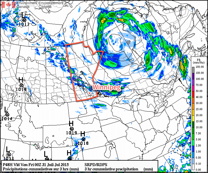
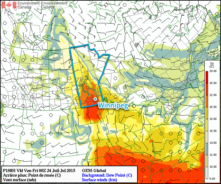
The RDPS shows a line of thunderstorms late Thursday cutting across Southern Manitoba.
Most indications are that a shortwave trough – evidenced above by high vorticity values at 500mb – will move through midday into the afternoon. As it pushes across Manitoba, it will bring with it the risk of a few thunderstorms; at this point no severe weather is expected should any thunderstorms get going.
Skies will clear out Thursday evening as the temperature drops into the mid-teens.
Friday
Not much to say for Friday other than it will be another beautiful day. Just a few clouds are expected as temperatures climb into the mid- to upper–20’s once again. There are some hints of some thunderstorm activity, but at this point it looks like it should remain well north of the Red River Valley. Temperatures will dip down into the mid-teens on Friday night.
After a very busy day across Southern Manitoba yesterday that brought strong winds but, more significantly, absolutely drenching rainfall to many areas, much quieter weather is in store for the weekend.
The weather over the coming few days will, fortunately, take little space to explain. For all the coming days, we’ll see daytime highs in upper 20’s or just cracking the 30°C mark. It will feel a bit warmer than that, though, as a moderate amount of humidity remains in the region. Dew point values will fall to around 16 or 17°C this afternoon, but then rebound back into the upper teens or low 20’s for Saturday & Sunday. This will make for quite a hot and humid weekend.
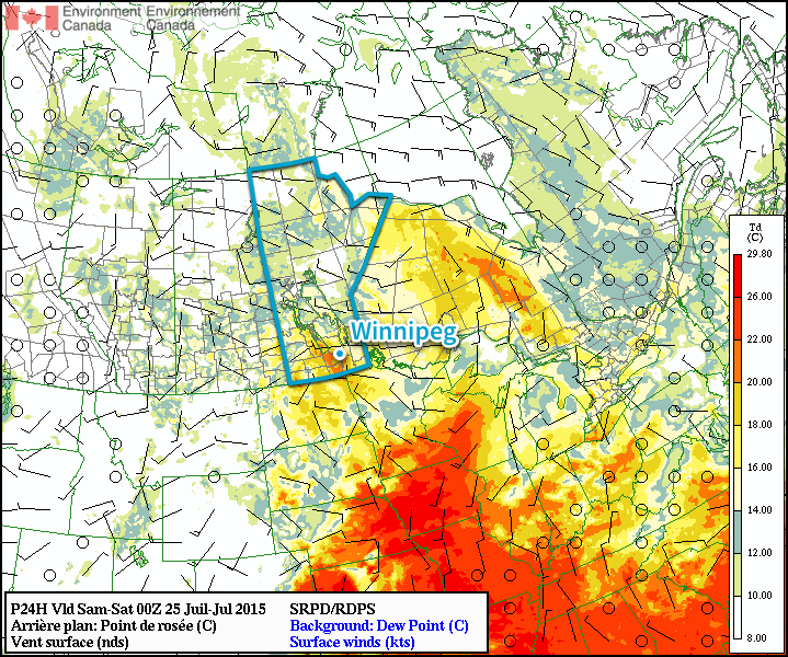
The orange colours in the Red River Valley show dew point values remaining near 20°C.
Winds will remain fairly light over the coming days. Overnight lows will sit in the upper teens.
Little precipitation is expected; and little is expected in the way pop-up showers or thunderstorms are expected. There’s a chance of some shower activity moving through tonight, but it’s not expected to be particularly significant.
Unsettled Start to Next Week?
The beginning of next week may potentially have a stormy and unsettled start as a low pressure system moving through the region brings another round of thunderstorms to Southern Manitoba. At this stage, it doesn’t look like nearly as widespread an event as the extensive system that affected Southern Manitoba on Thursday. With the heat and humidity in place, though, severe thunderstorms may be a possibility. As we move further into the weekend, we’ll be keeping an eye on things and issue a convective outlook for Monday or Tuesday if it looks significant enough.
The remainder of this week will be marked by a notable increase in the humidity as a deep southerly allows the moisture to build into Southern Manitoba. Alongside the sweltering conditions, a low pressure system pushing across the Prairies over the coming days will bring a threat for strong to severe thunderstorms across Southern Saskatchewan & Southern Manitoba.
Today will be a hot day with the humidity gradually building in through the day. Winds will strengthen through the day out of the south to southeast to around 30km/h or so as temperatures climb into the upper 20’s. Skies will remain mainly sunny with just a few clouds expected. While the humidity will be comfortable to start the day with dew point values around 14°C or so, the weather will get considerably stickier as the day progresses with dew point values climbing into the upper teens or perhaps even hitting the 20°C mark in the evening. This will make for very humid conditions with humidex values in the mid–30’s.
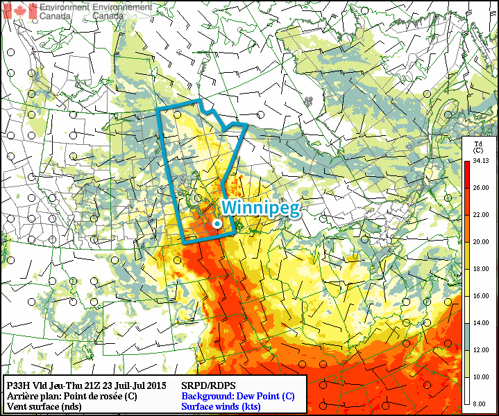
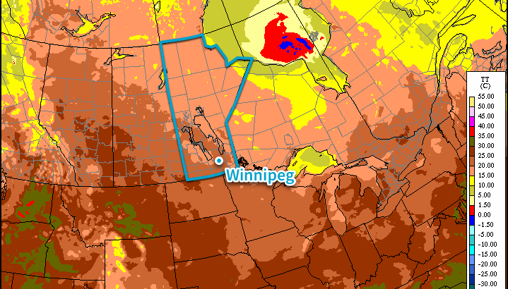
The RDPS shows dew point values climbing over the 20°C mark Thursday afternoon resulting in very humid conditions.
Thursday will be the significant weather day for the second half of the week as a trough of low pressure passes across Southern Manitoba. Temperatures will soar towards the 30°C mark with significant humidity as dew point values once again push towards the 20°C mark, making the afternoon feel more like the upper 30’s. Winds will be lighter on Thursday than they will be on Wednesday, but there may be some brief breeziness late in the morning or early in the afternoon.
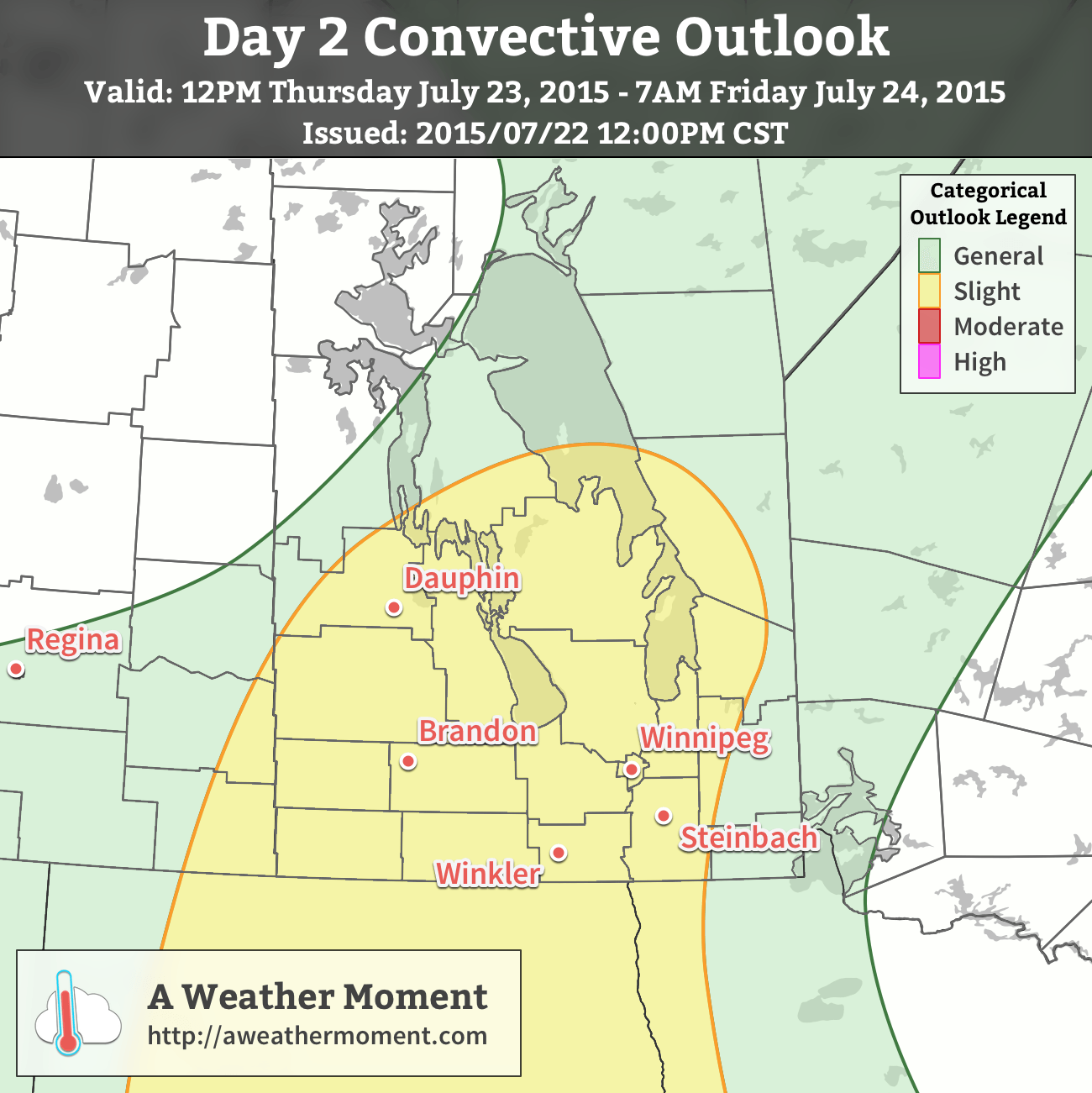
A slight risk of severe thunderstorms exists today across much of southwestern Manitoba extending into the Interlake and Red River Valley.
The heat and humidity will combine to pose a risk for some potent thunderstorm activity tomorrow afternoon. A trough of low pressure moving across the Red River Valley will serve as a trigger for convective activity sometime mid-to-late afternoon.[1] Winnipeg & the Red River Valley will see the risk for strong to severe thunderstorms – given a few conditions work out, more on that later – with large hail, strong winds and torrential downpours the primary threats. If an organized supercell manages to develop, the tornado threat with it (or them) will be slightly elevated. Looking through the guiding MIST principle for assessing convection:
Moisture: Abundant. Moisture transport coupled with vigorous evapotranspiration will combine to produce elevated surface dew point values near or exceeding 20°C by the end of the day.
Instability: Moderate instability with marked height falls ahead of an approaching shortwave coupled with the elevated moisture available through the boundary layer will produce MLCAPE values in the 2500 – 3000 J/kg range. The instability will carry into the evening hours with MUCAPE values remaining in the 2000+ J/kg range.
Shear: Pretty good. Bulk shear values of 20–30kt will increase towards 30–40kt in the evening hours. Additionally, low-level profiles show moderate veering. The wind profiles support supercell or multi-cell storm development with upscale growth likely in the evening hours.
Trigger: As mentioned, the trough pushing through the region associated with a low pressure system moving through the Dakotas will provide sufficient convergence to trigger thunderstorm activity.
The end result of all this is that thunderstorms are likely through Southwest Manitoba in the afternoon, with the threat pushing eastwards into the Red River Valley late afternoon into the evening. Storms will likely originate as supercells or multi-cell storms. Primary threats will be large hail and torrential rain, shifting towards hail/rain/wind as the storms organize & expand in coverage heading eastwards. Any supercell storms that manage to develop will likely pose a slight tornado risk.
Showers or thunderstorms are very likely Thursday evening/night as the system moves through. Stay alert of any watches or warnings issued by Environment Canada through the day into the evening on Thursday.
Friday will be a fairly quiet day. Things will stabilize behind the departing trough of low pressure, bringing clearing skies and a high in the upper 20’s with decreasing humidity. Expect a low in the upper teens on Friday night.
Summer Heat Returns for Weekend
The reprieve from the heat and humidity will be short-lived, however, as temperatures will climb back up to the 30°C mark with humid conditions returning as dew point values of 20°C or greater building back into the region. No precipitation is expected through the weekend.
Although a wildcard remains of how long nocturnal convection from Wednesday night will persist into the daytime hours on Thursday. ↩
Tired of the phrase “chance of a thunderstorm” and want to just have a couple days without rain? Good news! It looks like Winnipeg & the Red River Valley will finally shake the unsettled weather pattern and see a couple days of calm, pleasant summer weather with very little chance of precipitation thanks to an upper-level ridge that will build into the Eastern Prairies.
The coming few days will see gradually warming as we transition from the cool air mass left behind from the systems that tracked across the region on Saturday & Sunday into a warmer air mass pushing in from the west. Today will be the coolest day with a daytime high of just 22 or 23°C under partly cloudy skies. There may be some isolated shower or thundershower activity, but at this point it looks like it would be very spotty in the Red River Valley. Temperatures will dip to around 12°C tonight.
Tomorrow and Wednesday will both be beautiful summer days with highs climbing into the mid-to-upper 20’s under mostly sunny skies. Winds look fairly calm, although by Wednesday afternoon we could see southerly winds begin to strengthen. At this point it doesn’t look too bad – perhaps 30km/h with some gustiness on top of that – but if the pattern speeds up a bit, we could end up seeing quite windy conditions out of the south by then. Conversely, if the entire pattern is a bit slower we’ll see calm conditions throughout the day. Overnight lows both nights will be in the low-to-mid teens.
Hot, Humid & Stormy Weather Returns for End of Week
Looking ahead into the second half of the week, the trend seems to be for the hot and humid weather to return. As the upper ridge transitions across the region, deep layer southerly winds developing will tap into more humid air to our south and begin increasing the dew point. By Thursday evening, the dew point could be as high as 20–22°C, making it feel very sticky out there. Depending on the exact daytime highs, Thursday and Friday could both end up feeling more like the mid-to-upper 30’s instead of the upper 20’s thanks to the humidity.
The GDPS is forecast dew point values climbing into the 20-22°C range by Thursady evening.
In addition to all that heat and humidity, a low pressure system tracking through at the end of the week looks to bring the potential for strong to severe thunderstorms, likely on Thursday. More on that later this week!