High waves due to the strong winds in Gimli.

Colorado Low Slams Southern Manitoba Over May Long Weekend

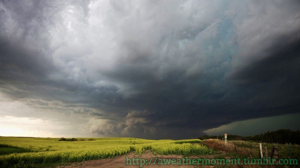
Southern Manitoba was slammed by a powerful Colorado Low this past weekend that brought a wide array of severe weather to the province. Between heavy rain, ice pellets, snow and very strong winds, the storm wreaked havoc on the regions infrastructure with widespread damage to trees, power outages, closed highways, structural damage and overland flooding.

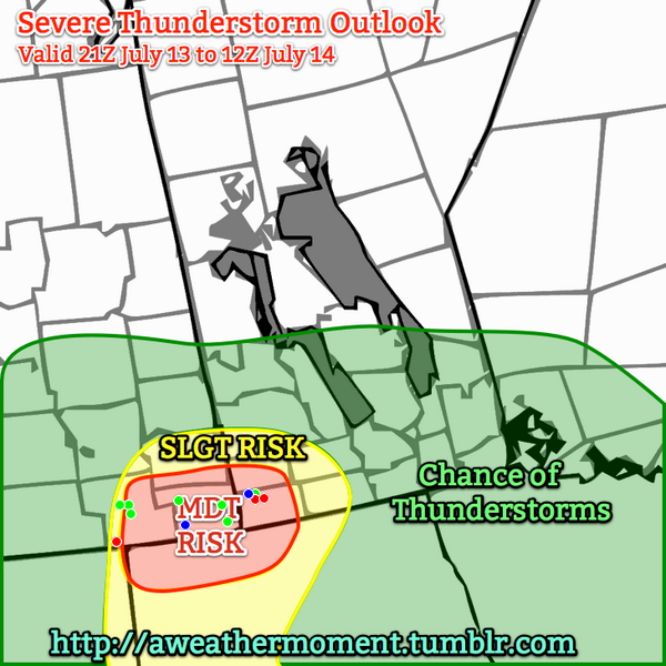
The system was, fortunately, well forecast by Environment Canada with fairly accurate forecasts issued in the days leading up to it alongside special weather statements addressing the numerous impacts the system may have on the region.

Significant Rainfall Began Saturday Afternoon

Fortunately, the weather was able to hold for much of Saturday. Temperatures climbed into the low 20’s across Southern Manitoba with increasing cloudiness. Rain & thunderstorms developed through North Dakota & Montana and lifted northwards through the day, first spreading into SW Manitoba in the afternoon and then eastwards and northwards through the evening and overnight period.

Some of the hardest hit regions were in SW Manitoba where hours of training thunderstorms & convective showers produced moderate to heavy rain. The Melita region was hit the hardest with 72mm of the grand total 90mm of rain falling by midnight on Saturday night. For areas further east, through, much of the rain fell through Saturday night & Sunday. Total rainfall amounts for Saturday and Sunday combined were:

Rainfall Totals for May 16–17, 2015 – Environment Canada & Manitoba Agriculture (*) Stations
Location Rainfall Total (mm)
Melita 90
Bede* 83
Gretna 63
Carman 60
Deloraine* 57
Deerwood 55
Morden 51
Kleefeld 48
Reston* 48
Dugald* 45
Pilot Mound 44
Emerson 43
Pierson* 43
Letellier* 41
Winnipeg (Forks) 41
Portage East* 40
Portage Southport 40
Woodlands* 38
Oak Point 37
McCreary 36
Winnipeg Airport 36
Pinawa 36
Great Falls 34
Carberry 33
Sprague 32
Virden* 30
Brandon 29
Fisher Branch 29
Cypress River 28
Glenboro* 27
St. Pierre* 25
Wasagaming 24
Dauphin 22
Teulon* 21
Killarney* 20
Wawanesa* 20
Minnedosa* 17
Eriksdale* 16
Roblin 16
Souris* 15
Berens River 14

This rainfall is in addition to the 25–50mm of rain many areas in the region saw just a couple days prior to this storm. There were several areas that saw significant overland flooding due to the sheer quantity of water that fell over the short time frame.

Additionally, there were reports of sewage back-up and spotty basement flooding across Winnipeg.

Then Came the Wind

Sunday is where the brunt of the storm impact was felt. As the main low pressure centre lifted northwards into the Dakotas, a strong 1037mb high pressure centre was building into the central Prairies.

Surface analysis for early Sunday morning.
This surface analysis for early Sunday morning shows the strong low in the Dakotas and the strong high building into the central Prairies.

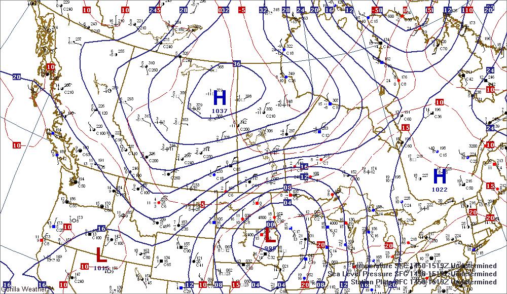
These systems produced a strong pressure gradient over southern Manitoba and produced some of the strongest, longest-duration winds for a major storm in recent memory. Winds were in excess of 50km/h for 20 hours in Winnipeg with a 6-hour stretch beginning late Sunday with winds of 60km/h or greater. Very strong gusts also accompanied the winds with Winnipeg recording the highest wind gust at 93km/h:

Peak Wind Gusts for May 17, 2015
Location Peak Wind (km/h) Time (CDT)
Winnipeg 93 6:44PM
Gimli Harbour 89 9:38PM
Carberry 87 4:57PM
Brandon 83 10:00AM
Kleefeld 81 4:14PM
Cypress River 81 5:01PM
Pilot Mound 81 2:45PM
Gretna 81 2:28PM
Melita 80 6:11PM
Emerson 80 4:21PM
Gimli 80 4:21PM
Porgae la Prairie 80 4:51PM

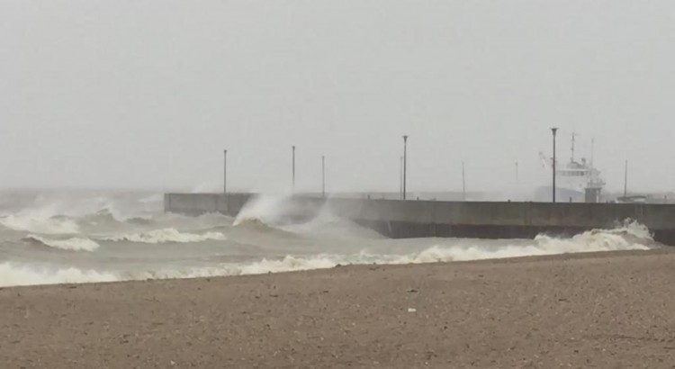
The winds may have been the most significant impact from this storm. The strong winds resulted in havoc on the highways, property damage, hundreds of downed trees, and widespread power outages. The strong winds also produced significant wave action on Lake Winnipeg and some overland flooding as rising lake levels resulted in the lake overspilling its banks and pushing inland in some locations.

Winds tapered off to 40 gusting 60km/h on Sunday night, but remained fairly strong until tapering off Monday afternoon.
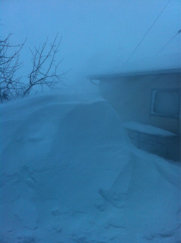
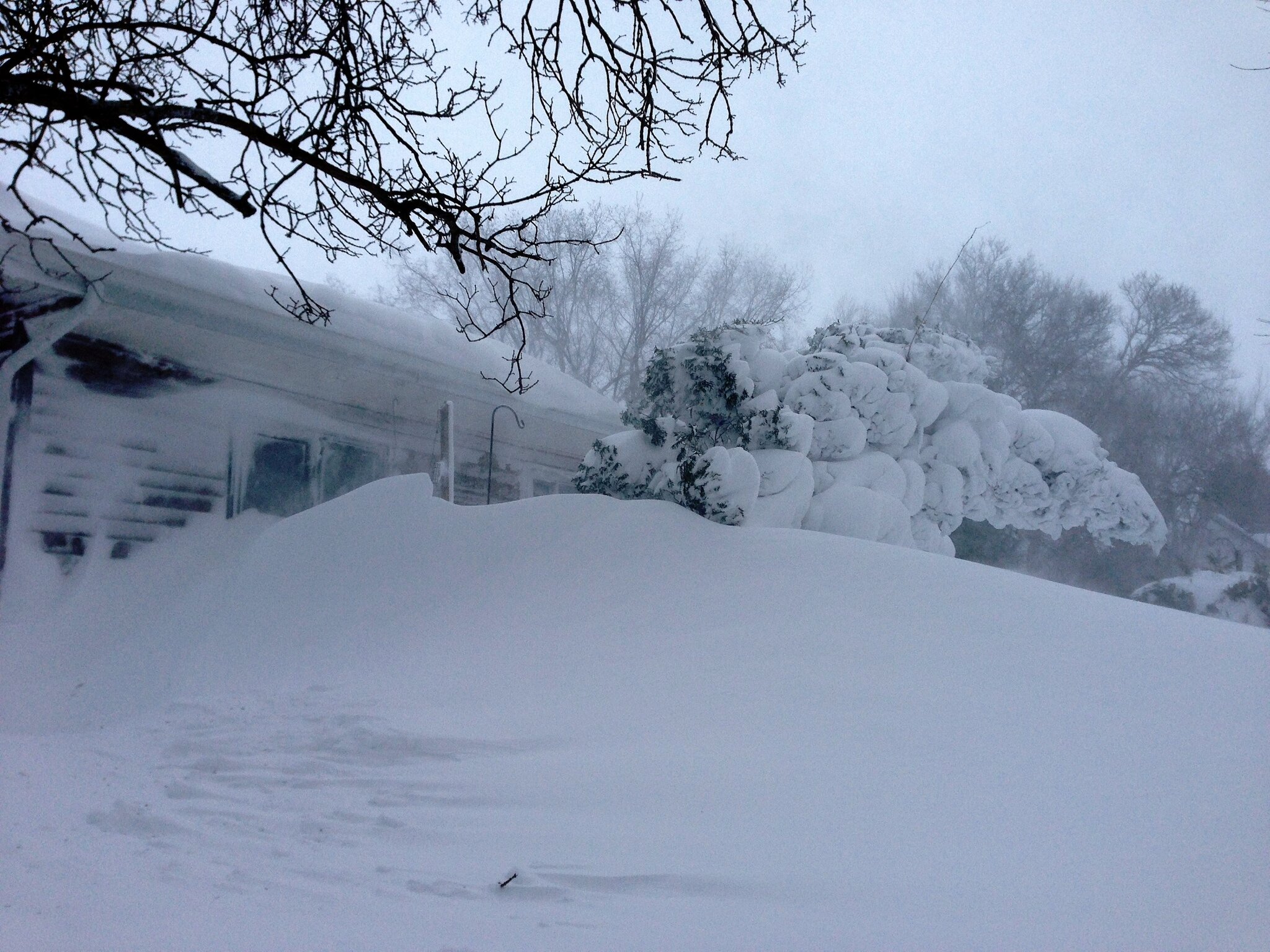
Oh, Snow Too

If the rain and the wind wasn’t enough, cold air moving in with the high pressure system resulted in precipitation switching over to ice pellets then snow beginning over Parkland Manitoba and then spreading southeastwards through the Interlake, Red River Valley & Whiteshell through the afternoon and evening. Areas through the Interlake southwestwards towards the Melita region saw the heaviest snow, with MacGregor reporting the highest amount of snow at 15cm. Amounts of 10–15cm were seen from Arnes, on the western shores of Lake Winnipeg, through Teulon, MacGregor, Treherne and down towards Boissevain:

Snowfall Totals for May 17–18, 2015 – EC Spotters & Social Media
Location Snowfall Total (cm)
MacGregor 15
Teulon 15
Arnes 10
Boissevain 10
Treherne 10
Hollow Water FN 5
Albert Beach 5
Dauphin 5
Deloraine 5
Wasagaming 5
Winnipeg 3

In Winnipeg, we saw just a few cm of snow on Friday evening and overnight. Flurries persisted through Monday but temperatures were warm enough to prevent any more accumulation.

All in all, this was certainly one of the most powerful storms Southern Manitoba has seen in a good long while. Perhaps the best thing that can be said is that at least it happened now and not a month earlier, where almost certainly it would have been a historic blizzard.

Severe Thunderstorms Ravage Saskatchewan and Manitoba

A line of severe thunderstorms tore across southeastern Saskatchewan and southwestern Manitoba yesterday producing widespread damage due to rain, hail, and what is increasingly likely a tornado.

A verification of the AWM Severe Thunderstorm Outlook issued on Saturday morning. Green dots: Severe Hail Reports. Blue dots: severe wind reports. Red dots: tornado reports.

A potent severe weather setup was in place yesterday as a trough of low pressure began to move it’s way from Alberta into the hot, humid air that was pushing into SE Saskatchewan. Ample moisture, heat, instability and wind shear was in place for the development of severe thunderstorms and – given the strongly veering wind profile – the likely development of tornadic supercells. With this in mind, we issued our morning severe weather outlook with a moderate risk for severe thunderstorms in the Estevan, Carlyle, Moosomin, Virden & Melita forecast regions, with a slight risk extending further eastwards into the Pilot Mound & Brandon regions.

Saskatchewan Pounded By Large Hail

Supercell thunderstorm developing just SW of Weyburn, SK at 1900Z.

Supercell thunderstorm developing just SW of Weyburn, SK at 1900Z.

Storms developed earlier than expected; by 1900Z there was a supercell taking shape not too far SW of Weyburn, SK. This supercell ended up being the storm of the day, lasting over 8.5 hours before finally dying near the U.S. border near Gretna, MB. A line of storms quickly developed extending from the main supercell SW into Montana. It rapidly developed into a line of 5 or 6 supercells that all began rotating quickly and producing torrential rain and extremely large hail. Environment Canada had issued a tornado watch for the region around 9:30AM local time which mentioned the threat for supercell thunderstorms capable of producing torrential rain and large hail in addition to the threat for tornadoes.

The reports began flooding in on as the severe storms began impacting larger communities. Environment Canada issued a timeline of reports it received that went like this:

Location Time (Local) Report
Weyburn 1:49 PM Quarter size hail
Hume 2:00 PM Loonie hail
Weyburn (8 km W) 2:21 PM Golf ball hail
Arcola 2:43 PM Funnel cloud
Kisbey 2:45 PM Quarter size hail
Weyburn (5 km W) 2:55 PM Golf ball hail
13 km SE Weyburn 3:00 PM Grapefruit size hail
16 km SE Weyburn 3:00 PM Golf ball hail
Minton (13 km S) 3:15 PM Possible brief tornado
Forget 3:20 PM Golf ball hail
Lampman 4:19 PM 50 mm rain, 80 km/h gust
Redvers 4:29 PM Toonie size hail
Oxbow (8 km N) 4:45 PM 50 mm rain in 15 minutes

Photos that began coming in on Twitter were pretty incredible. Tight lowerings on storms were showing that they were spinning quite intensely and numerous funnel clouds were spotted. But int the end, the big story in SE Saskatchewan was the rain and hail.

Large hail near Weyburn, SK

A photo of large hail near Weyburn, SK. Credit: Craig Hilts

There were numerous reports of tennis ball sized hail upwards to one report of grapefruit sized hail (a grapefruit is around 9cm wide). The hail produced by these storms produced significant damage to crops in the region as well as to personal property, with many reports of car windshields being broken by the hail and images showing up on Twitter of house windows being smashed.

Photo of flooding in Bienfait, SK

Picture of flash flooding in Bienfait, SK. Credit: SK storm chaser @NickTheBody.

Flooding was also a problem in numerous places as the storms dumped unbelievable amounts of rain. At some points, rainfall rates exceeded 200–225mm/h as torrential rain brought zero-visibility conditions. @NickTheBody caught the snap above of the flash flooding that occurred in Bienfait, SK after a thunderstorm rolled through.

Doppler RADAR showing strong couplet near Carlyle, SK

Doppler RADAR showing a very strong couplet as as supercell thunderstorm bears down on Carlyle.

As the storms pushed further east, however, they began to take on some very ominous characteristics. As the storms pushed deeper into the moist, warm air the winds at the surface began to back a little bit more; further west surface winds were mostly out of the south, but as they moved towards the Manitoba border the surface winds became more and more southeasterly. Very quickly strong rotation began to show up on RADAR, with the main supercell we’ve been tracking showing a very intense velocity couplet as it moved towards Carlyle, SK. The storms had always shown rotation since nearly the beginning of their lifespan and had the capability to produce tornadoes at any time, but it was at this point these storms began to look like they could produce a large, long-lived tornado. The storm about to hit Carlyle, in particular, was becoming the storm to watch.

Supercell Tears Across Southwest Manitoba

And watching it we were! Matt, A Weather Moment contributor and @lovestormsMB was out chasing and had been on the storm for hours at this point. While hopes of seeing anything rapidly diminished as the storm became what is known as a HP supercell[1], he was able to feed important information via his Twitter account.

Supercell thunderstorm over SE SK / SW MB

HP Supercell just SW of Carlyle, SK on Saturday evening as the storm approached the Manitoba border. Credit: @lovestormsMB

This storm – for lack of any better terminology – looked vicious as it moved into Manitoba. It was tracking along Highway 13 and moved straight towards Reston – a town that has already had to deal with multiple severe storms this year already – and Pipestone, a town somewhat famous for the Pipestone tornado.

Unfortunately, it didn’t take long for word to come that there was certainly significant damage occurring under that storm. Environment Canada also issued a timeline for reports it received on the Manitoba side:

Location Time (Local) Report
Sinclair (7 km N) 6:00 PM Ping pong size hail, severe winds with trees down
Reston 6:49 PM Nickel hail, 42 mm rain
Pipestone 7:00 PM Tornado, significant damage
Pipestone (20 km E) 7:30 PM Tornado, golf ball hail
Hartney 8:00 PM Possible tornado

Dramatic photos began coming in from the Pipestone region as well:

HP Supercell Approaching Pipestone

Photo of the HP supercell near Reston, approaching Pipestone, MB. Credit: @lovestormsMB

Downed tree in Pipestone

Photo of a large tree snapped in half in Pipestone. Credit: Tim Smith / Brandon Sun

Mobile home thrown into the rink in Pipestone

Photo of a mobile home thrown into the rink in Pipestone. Credit: @Snipe_All_Day

Destroyed cattle shed in Hartney, MB

A destroyed cattle shed in Hartney, MB. Credit: @LD_StVital

The clean-up continues today in Pipestone and Hartney while damage continues to be assessed in southeastern Saskatchewan. Unfortunately for those in Saskatchewan there will be little time to recover as another potent setup for a severe storm outbreak will be in place Monday afternoon bringing, once again, a tornado, torrential rain and large hail risk. Regions in SW Manitoba should be a little safer this time. We’ll have the full details of that in tomorrow’s blog post.


  1. The “HP” in “HP supercell stands for ”high precipitation.” HP supercells often have obvious, dramatic structure form afar, but little of the internal workings are visible due to the copious amounts of precipitation falling out from them. HP supercells are extremely dangerous storms as any tornadoes they produce are often hidden from sight behind all the rain.  ↩

Special: Louis Riel Day 2013 Blizzard

Louis Riel Day was marked this year by a significant blizzard that brought much of the Red River Valley to a standstill. While snowfall was relatively light, with only 5–10cm reported in most localities (although a few pockets of 10–15cm did exist through the Southern portion of the Red River Valley), strong northerly winds that gusted as high as 70–80km/h produced blowing snow that gave whiteout conditions through most of the Valley.

Warm Front on Sunday, February 17

This system was marked by a warm frontal passage on Sunday near noon. Strong southerly winds brought local blowing snow to the region as an area of precipitation blossomed along the warm front. Here in Winnipeg, the precipitation fell as ice pellets first before switching to snow. Further south, a little deeper into the warm air, moderate band of freezing rain developed, coating Steinbach, as well as Highway 1 East, Highway 52 and Highway 59 in a layer of ice.

Freezing Rain in Steinbach 1

Freezing rain accumulating in Steinbach. Credit: @andrewpenner78

After this band went through, then winds slowly died off and we were able to enjoy a relatively nice afternoon. Near Steinbach, however, there were reports of numerous cars in the ditch due to “skating-rink”-like road conditions.

Cold Front and Blizzard, Sunday/Monday February 17/18

The cold front associated with this system passed through Winnipeg between 6–7PM CST; winds switched from southerly to calm to northerly and cloud ceilings rapidly dropped to 300–400 feet and a few hours of freezing drizzle happened in the low-level mixing immediately behind the cold front. By 10:30, winds began to pick up and the freezing drizzle switched over to snow. By midnight, visibilities had dropped to ½SM and would stay there or worse until roughly noon on Monday. To our south, conditions remained practically a white-out for an additional 6–7 hours, with visibilities not lifting above ¾SM until 7PM CST as sustained winds of 50–60km/h battered the area.

24 Hour Rainfall Accumulations

24 Hour Precipitation Accumulations

In total, around 3–6cm fell in Winnipeg, with areas on the south side of the city receiving nearly twice that of the central/northern portion. South of Winnipeg, snowfall amounts were appropriately higher:

  • Winnipeg: 3–6cm
  • Morden: 8cm
  • Morris: 10cm
  • Pinawa: 8cm
  • Steinbach: 11–13cm

As winds abated, colder air began working into the region. The temperatures have been on a downward trend all the way from Monday morning to the time of publishing this; temperatures are beginning to level off at –27°C.

Impacts

Twitter was a great source of information for what was happening during this event; between weather reports flooding in on the MBstorm hashtag and immediate communication about road conditions, it was relatively easy to get a grip on the significance of this system.

Some pictures came in early on Sunday as the band of freezing rain pushed through Steinbach:

Freezing Rain in Steinbach 2

Freezing rain accumulation on a car in Steinbach. Credit: @andrewpenner78

As the winds picked up, blowing snow quickly became the predominant impact over the Red River Valley:

Snow Drifts in Niverville

Snow drifts rapidly growing in Niverville. Credit: @jim_311

Some truly impressive images came out of Winnipeg Beach on Monday morning:

Snow Drifts in Winnipeg Beach

Massive snow drifts in Winnipeg Beach. Credit: @annhogie

Massive Snow Drifts in Winnipeg Beach

Massive snow drifts in Winnipeg Beach. Credit: @annhogie

Massive Snow Drifts in Winnipeg Beach

Massive snow drifts in Winnipeg Beach. Credit: @annhogie

Conditions on highways were fairly brutal on Monday:

Blowing snow on Highway 311

Blowing snow on MB Highway 311. Credit: @jim_311

Blowing snow Near Emerson, MB

Blowing snow in Emerson, MB.

Even within cities in the southern Red River Valley, conditions got quite bad:

Blowing snow in Winkler, MB on Monday morning.

Blowing snow in Winkler, MB on Monday morning.

Many highways were closed for this event:

  • Highway 16 from Hwy. 50 to Hwy. 466
  • Highway 1 West from Portage to Winnipeg
  • Highway 75 from Winnipeg to the US Border; I–29 from the US Border to Grand Forks, ND
  • Highway 5 from Neepawa up to St. Rose.

Numerous traffic accidents occurred as well, keeping the RCMP quite busy:

  • A 10-car pileup occurred in St. Francois Xavier that involved several semi-trucks. No injuries.
  • 3 semi-trailer trucks collided on Highway 1 west of PR 332.
  • Two semis smashed through road barricades in Headingly. A police cruiser was damaged by debris but nobody was hurt.

Perhaps most tragically, one man died in this storm. A 54-year old man was found dead near Landmark. He had left his car after driving into the ditch on road 45N. The road was slippery and visibility was near-zero at the time.

This was a very significant blizzard that had huge impacts on the Red River Valley. Fortunately, residents had plenty of time to prepare as Environment Canada issued special weather statements on Friday morning addressing the potential for a significant blizzard and carried them through to the issuing of warnings.

<

p>If you have any pictures you’d like to share, leave them in the comments below or send them to aweathermoment at shaw dot ca.

The Elie Manitoba Tornado

5 Years Ago Today; A Personal Account of the Elie Tornado

5 years ago today, Canada’s first official F5 tornado touched down in the small community of Elie, Manitoba. It destroyed several homes, completely sweeping them away from their foundations. Trees were debarked, vehicles were destroyed, and the town’s flour mill was damaged. While it was originally rated an F4 tornado, after extensive investigation by Environment Canada it was upgraded to the country’s first F5 tornado, with estimated wind speeds exceeding 420km/h.

The following is a personal account from a friend of mine, storm chaser Justin H., who was out that day and witnessed the tornado first hand. I thought it fitting that on the 5th anniversary of the event we would have an account of the event from somebody whose enthusiasm for severe weather goes nearly unmatched. Justin, thank you for writing this and contributing to the site; I hope that you all enjoy reading about his experience.


A Personal Account of the Elie, MB Tornado

Written by Justin Hobson

I remember this day like it happened just yesterday. This tornado event will be forever etched in my memory as long as I live. The sights, the sounds, the smells. I still remember shifting my head up to take in the full extent of what was later known as Canada’s strongest documented tornado.

Conditions were favorable for severe thunderstorms on June 22nd, 2007 over much of Southern Manitoba as winds turned and increased with height in combination with high heat and humidity. These conditions favored rotating thunderstorms (Supercells). Storms were supposed to form along a cold front that was oriented from NE to SW across WesMan. A warm front was draped to the east through the Interlake with a surface trough dissecting the warm sector in half oriented north-to-south through Portage La Prairie. The warm sector was capped (inhibiting convection) for much of the day, but a tornado threat existed from the get-go if the cap were to be removed. The cold front was the definite trigger for storms but what was unusual about this day was that the combination of gravity waves originating from the MB Escarpment, horizontal convective rolls within the boundary layer, and moisture convergence allowed the cap to erode before the cold front arrived paving the way for explosive supercell development around 5:30 pm local time (2230 UTC) just to the NW of Elie.

I left work that afternoon with tornado chances fading because of the capping issues that were present all afternoon. I had planned to chase this setup for a week prior (models did a decent job in advance) so I was feeling upset as I was looking forward to chasing in my backyard around Winnipeg. As I left downtown and headed down Highway 3 towards home, I could see what looked to be like a volcanic eruption to the NW of my location. There was explosive cell development occurring southeast of Lake Manitoba. I continued home and was starting to get excited. The first thing I did upon arriving at my house was check the radar on weather office. Woodlands radar was already detecting this cell with some returns starting to show up NW of Elie. I said to myself, well I’ll pack up my gear in the mean time and if the next scan gets better…I’ll go for it. I grabbed my Dad’s camera, a baseball cap and went back to my computer. I clicked the reload page button a few times before the new image displayed its true beauty. A supercell was being born. It was in the right spot within the area of low pressure, and it was in the tornado zone that was analyzed earlier that afternoon.

I headed out, this time on Highway 2 towards Starbuck, Manitoba. Once I arrived in Starbuck I started to get rained on fairly heavily by the storm as I shifted directions and headed north out of town. I thought to myself, oh great the cell has already collapsed. I continued pressing north. Visibility was reduced as the rain got heavier and heavier. Some small hail (pea-sized) began hitting my car as I arrived at a crossroad that would take me west towards Elie (1 mile south). I headed towards Elie as the rain/hail began to ease. What I saw next was remarkable. A wall cloud! I couldn’t believe it…this was the first wall cloud I’ve seen that showed tor’ific potential. I parked on a gravel road just to the south of Elie, I placed my camcorder on the roof of my vehicle, hit record and watched.

Within minutes funnels began to form. I was so excited! A funnel would form, go back up, then a new one would form and reach a little further towards the ground. This happened several times before a long rope funnel reached toward the ground. My first tornado! I snapped some pictures and called Environment Canada to report what I was witnessing. Within minutes, the tornado grew larger, then smaller again, and then it really got its act together. It grew into a large cone tornado that almost looked blue from my vantage point. This was truly amazing. I couldn’t believe what I was witnessing.

“Her last words to me were “Oh…well…don’t die!”

My heart was racing…I had knots in my stomach (like what you get just before they pull the trigger at a 100m race). I was on the phone with Environment Canada reporting the change in shape and size to a forecaster named Curtis. Once I called that report in, I was on the phone with some friends as well as my sister Bryanne. She told me she heard that there was a tornado near Winnipeg. I told her I was right beside it near Elie…and that I thought that the tornado would hit the town…her last words to me were “oh…well…don’t die!” I put the phone down and took in the sight. I couldn’t believe what I was seeing…after 10 years of being passionate about severe thunderstorms…and after 4 years of chasing…I’ve finally done it.

Video of Canada's first F5 Tornado (upgraded from F4) taken from one mile away that severely damaged the western part of Elie, Manitoba on Friday June 22nd, 2007

I vividly remember how calm it was and was very observant to what was occurring all around me. I remember hearing Killdeer birds chirping away, as well as frogs in the nearby ditches. I also remember mosquitoes flying around and buzzing in my ear, and I can also remember hearing the constant low rumble of thunder to the east of my location. All of this was occurring while the tornado peacefully and slowly twisted its way across open fields towards the southeast. A passerby named Jason stopped by and was just as excited as I was. We exchanged a few words and I even snapped a picture of him with the tornado in the background. I obtained his email address to forward him the picture later on, and he was off to check on his house…he thought it may have been hit. By the time he left, the tornado grew larger and became darker in appearance. I could hear the tornado now. The only thing that resembles the sound in the real world is that of a waterfall. It was like someone was turning up the volume of this ‘waterfall’ as the tornado sluggishly crept closer.

“The tornado continued to hurl debris which could now be seen very high up into the sky wrapping around the tornado.”

At this time the tornado wasn’t growing larger…it appeared stationary for a brief time before it suddenly began moving to the right (East). Shortly after shifting its track I could here different sounds as large pieces of debris were being hurled around the circulation. It was hitting the town. I began to feel uneasy. Lightning started to grow more intense so I fled to my car with my camera and continued to record the tornado. Power flashes occurred for a brief moment as the tornado severed power poles while impacting the neighborhood on the west side of town. A friend named Chris called me and said that he heard there was a tornado near Elie and that the clouds over his head in SW Winnipeg were crazy (Mammatus likely). I told him I was near Elie and the tornado was hitting the town and that I would call him back later. He said to stay safe and hung up.

The tornado continued to hurl debris which could now be seen very high up into the sky wrapping around the tornado. The tornado was moving to the left now (West) where it grew thinner, and thinner, then suddenly disappeared. It was over? I wanted to get out of the area just in case the tornado redeveloped over my head. Shingles and insulation began to hit the vehicle and land all around the highway as I pressed north towards town. As I entered the town I could see a police car, an ambulance and what looked to be two dated fire trucks heading down a residential street towards the area that was impacted. There were several local residents rushing to the scene so I didn’t enter the town.

Upon making that decision I looked to my West and saw another tornado. I quickly did a U-turn and began to record the tornado as I drove back to the south towards Highway 2. The tornado was large and lasted for quite some time before becoming wrapped with rain and dissipating. This tornado was later rated an F3 after devastating a farmstead near the town of Oakville.

Well that is my story of the Elie, Manitoba, F5 tornado that occurred on June 22nd, 2007. This is the first time writing a detailed personal account of the event and it gave me welcomed goose bumps in doing so. I hope you enjoyed it!

Justin Hobson has recently completed a masters thesis on the F5 tornado in Elie. You can view it here.