This week will remain on the cool side, but temperatures won’t be far from normal.
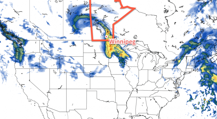
Today will be mainly cloudy with temperatures near the freezing mark. The main weather feature in the short-term will be a low pressure system passing to our south today. This system is expected to spread some light snow throughout southern Manitoba this afternoon into this evening. Accumulations in the Winnipeg region aren’t expected to be more than one or two centimetres, but areas closer to the U.S. border could see somewhat larger amounts. Winds will be from the east at 20-30 km/h.
A low pressure system passing to our south will bring a chance of flurries today
Skies are expected to gradually clear on Tuesday as a dry north-easterly flow develops over southern Manitoba. Temperatures are expected to be just below zero in most areas, which is slightly below seasonal for this time of year. Winds will be north-easterly at 20-30 km/h.
Wednesday will be mainly sunny, with temperatures again just below the freezing mark. A surface high pressure system is expecting to reside over southern Manitoba, allowing for those sunnier skies and light winds.
Long Range
The long range forecast shows generally seasonal to below-seasonal weather through the end of March. There are no large warm-ups currently in the forecast.
Winnipeg’s seasonal daytime high is currently 1°C while the seasonal overnight low is -9°C.
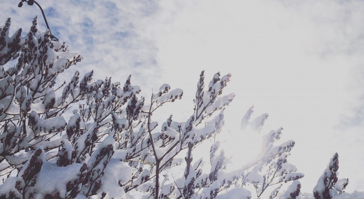
After a stretch of weather that brought record breaking temperatures, record breaking dew points, and new daily rainfall records[1] before shifting into a weird weather pattern that brought moderate-to-heavy snow to much of southern Manitoba (with a rather beautiful aftermath, pictured above), the weather over the coming days will be downright dull as a benign pattern brings seasonal temperatures to Winnipeg.
In a rather nice change of pace, there isn’t too much to talk about regarding this weekend’s weather. Near-seasonal temperatures will be in place throughout the weekend with daytime highs hovering in the 0 to +2°C range while overnight lows hover between -6 to -8°C. Skies will progressively become more cloudy with a sunny day today, a few clouds tomorrow, and mixed skies on Sunday, but no precipitation is expected. Winds will remain quite calm throughout the weekend with the strongest winds on Sunday at just 20km/h or so.
Long Range: More Active Week Ahead
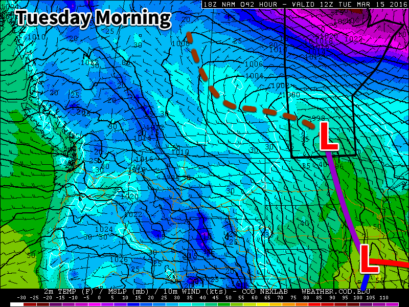
Next week is looking a little more active with a storm system expected to move through on Monday night & Tuesday. It’s too early to try and pin down too many specifics, but overall it appears that it will spread 5-10cm of snow across Southern Manitoba followed by some gusty northerly winds that may produce some local blowing snow.
The GDPS is showing a solution further south than other long-range models, pushing Tuesday’s system southwards into the United States
Towards the end of next weak it also appears that we may see another weak disturbance produce some light snow over the region.
Temperatures will be fairly consistent next week with daytime highs and overnight lows expected to be near-seasonal.
Winnipeg’s seasonal daytime high is currently 0°C while the seasonal overnight low is -10°C.
The shift back to closer-to-seasonal weather will feel like quite an abrupt change given the marked warmth that’s been in place much of March so far. Fortunately, even with the cooler weather, daytime highs will remain above the freezing mark, and with little snow left and not too much expected to fall, it gets harder and harder for the cold air to stick around[1] as the sun continues to increase in strength.
The low pressure that brought yesterday’s rainfall to the Red River Valley will dominate the weather for two more days before things gradually shift to a more neutral set-up.
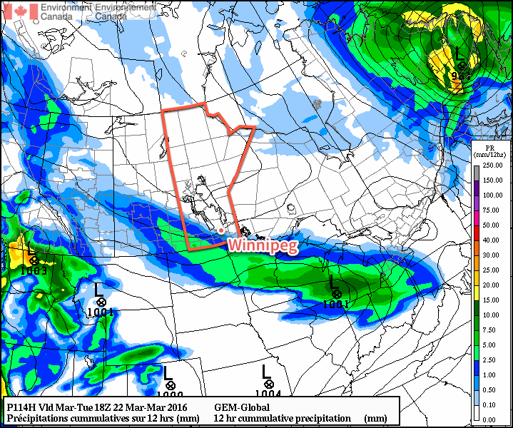
Some say what goes up must come down, and while not typically true about the weather, today we’ll see the area of precipitation that pushed northwards into Central Manitoba slump back southwards throughout the day as an inverted trough extending west-northwestward a from the main low pressure system in NW Ontario rotates southwards around the low. This will result in some showers and cooler air pushing into the Red River Valley through the day. As the precipitation moves in from the northeast, the rain will—at some point—switch over to snow. The flurries will continue through the evening and overnight before tapering off on Thursday morning.
12hour preciptation accumulations forecasted for Wednesday afternoon & evening from the RDPS.
Temperatures will climb to around 3-4°C this afternoon and then drop with the cooler air to a low near -3°C tonight. Winds will fairly breezy today out of the northwest at around 30 km/h with gusts up to 50km/h or so. To the southwest of Winnipeg, winds will likely be a bit stronger at 40 gusting 60 km/h. The winds will ease tonight as the axis of the inverted trough moves into the region.
Thursday will be an unexciting day compared to the past week. Any lingering flurries will taper off early in the morning and leave Winnipeg with mainly cloudy skies and temperatures gradually climbing towards a high of 2°C. Winds will be out of the north at 20-30km/h. Skies will remain cloudy tonight as temperatures dip to a low near -3°C with winds slowly easing off.
Friday will once again bring mainly cloudy skies and a high temperature near 3°C. Winds will be light and no precipitation is expected. Skies will remain fairly cloudy on Friday night as the temperature drops to a low near -2°C.
Winnipeg’s seasonal daytime high is currently -1°C while the seasonal overnight low is -11°C.
Long Range: Continuing Cloudy, Chance of Flurries
Heading into the weekend, it looks like we’ll likely continue to see a fair amount of cloud as a weak trough remains in the region. While Winnipeg won’t likely see any snow, there is a very slight chance of some flurry activity through the region. Should any snow develop, amounts are expected to be minimal and in most cases likely won’t even accumulate. Temperatures are expected to remain slightly above seasonal.
The weather will turn more active next week as a zonal flow develops aloft and multiple shortwaves ripple across the Prairies. Multiple storm systems are forecast to track through next week, each bringing a mix of wintery precipitation. Temperatures will remain slightly warmer than seasonal through the period.
Snow is so effective at keeping temperatures cool due to its white colour. Snow can reflect much of the sun’s energy, limiting the ability for temperatures to warm up. Once the snow cover is reduced or eliminated, the darker ground absorbs more sun and helps temperatures warm up more quickly. ↩
We’ll see one more nice day today before a potentially significant weather system affects us on Tuesday and Wednesday. Rain and snow is expected in southern Manitoba with this system, but exact amounts remain unclear.
Today will be another very nice day. Temperatures will climb into the mid teens over much of southern Manitoba, allowing our snow melt to continue. Many rural parts of southern Manitoba are already snow-free, but there is still snow to melt in sheltered areas. Skies will be mainly sunny, with breezy south-east winds.
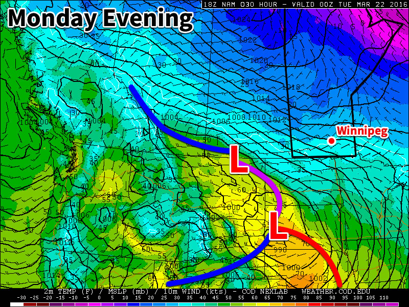
A major low pressure system will affect southern Manitoba this week
A major low pressure system is expected to affect southern Manitoba on Tuesday and Wednesday. This system will bring a combination of rain and snow, which makes it difficult to forecast. At this time it appears that rain will be the main mode of precipitation over the Red River Valley. Models disagree widely on potential accumulation, so it is difficult to say exactly how much rain will fall. A “best guess” is that Winnipeg will see about 5-15 mm of rain. More or less rain could fall depending on how the system evolves.
We will continue to be under the influence of this system on Wednesday, but temperatures will fall as we experience a stiff north-westerly flow. As a result of this cold air surging in from the north, rain is expected to change over to snow, with a couple centimetres of accumulation being possible. The exact amount of snow will depend on how much the system stalls over our area and how much cold air manages to infiltrate southern Manitoba. High temperatures on Wednesday are currently expected to be near 2C, which would not favour large accumulations.
Long Range
The end of the week is expected to be colder as the system from earlier in the week pulls down colder air from the north. Longer range models suggest that the second half of March will see a cooler pattern with outbreaks of colder arctic air. However, if we remain mainly snow-free following this week’s system, it will be difficult for very cold conditions to last long as the darker soil will be able to absorb much more sunlight than snow would.