This week will remain seasonably warm, although not quite as warm as last week. There will also be another chance of snow by the middle of the week as a low pressure system pushes up from the south.
Today will be seasonably warm, but mainly cloudy. We’ll be under a breezy north-easterly flow as a strong surface high sits off to our north-east. Temperatures will sit just below the freezing mark with little change throughout the day.
Tomorrow will be mainly cloudy once again, but this time there will be a slight chance of flurries. Any snow that does fall will not accumulate to much. Temperatures will sit in the mid minus single digits with a light easterly wind.
Just one guess of the snow swath expected with a low pressure system passing by on Wednesday.
A stronger low pressure system is currently forecast to affect southern Manitoba on Wednesday. This will be a Colorado Low type system, which is expected to mainly affect areas to our south, but may also bring light to moderate snowfall to parts of southern Manitoba. At this point it appears that areas along the US and Ontario borders will see the most snow, but it’s too early to speculate on possible accumulations. Stay tuned for more updates.
Long Range
The long range forecast suggests that we’ll continue to slide closer to seasonal temperatures in the short to medium term. That means high temperatures near -10C and low temperatures near -20C. However, ensemble guidance continues to hint at high probabilities of above-normal weather as we move toward Christmas, so any prolonged cold snaps appear quite unlikely through the end of December.
Slightly cooler temperatures have moved into the Red River Valley, but they won’t be enough to break our trend of unseasonably warm weather as daytime highs and lows continue to sit between 5 to 10°C above normal. Alongside the cooler but still relatively mild weather will be a whole lot of cloud and a chance for some more snow across the region.
Today’s weather will be predominantly influenced by a ridge of high pressure extending from the high Arctic southwards through Nunavut, Manitoba and into North Dakota. Unlike some Arctic ridges, this one is fairly weak, and as a result, instead of crisp blue skies and bone-chilling cold, we’ll see grey skies, cool easterly winds, and a slight chance of flurries.
With all the cloud cover entrenched over the region, temperatures today will be fairly mild. Daytime highs through the Red River Valley should end up sitting around –1°C.
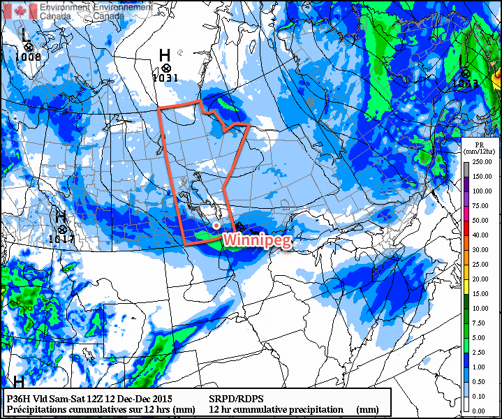
Another shot of light snow is in the cards for tonight, however, as a band of snow slowly spreads northeastwards out of the United States. The snow will develop and through the day on the U.S. side of the border as a low pressure system, ejected eastwards from yesterday’s explosive Pacific-coast storm, develops through the Northern Plains. The band of snow will slowly push to the northeast and move into southern Manitoba through the overnight period. For most places, less than 1–2cm is expected, however near the U.S. border, slightly more may fall, totalling up to 2–4cm by Saturday morning. Expect an overnight low near –5°C.
The RDPS is forecasting light snow across much of the Southern Prairies on Saturday night.
Saturday will bring more cloudy skies and widespread light flurry activity. Temperatures will continue to be mild with daytime highs around –2 or –1°C, which when combined with the fact that there won’t be much wind to speak of, will make for quite a pleasant December day. The flurries will taper off in the evening as temperatures dip just a few degrees to about –5°C.
Mild weather continues on Sunday under cloudy skies as slightly warmer air builds into the southern portion of the province. Daytime highs will climb 1–2°C higher than Saturday and sit near the freezing mark with relatively light northeasterly winds. No organized snow is expected on Sunday, so all in all, it will likely be a pleasant end to the weekend! Expect temperatures to dip to around –5 to –7°C on Sunday night.
Long Range: Does the Warmth End?
This section of the forecast has been a broken record so far this winter: continuing mild. And, at the moment, that’s not going to change. In fact, over the past week and a bit, several agencies have re-run seasonal forecast models for North America and they all continue to forecast the same thing: generally mild weather with below-normal precipitation.
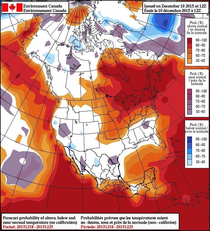
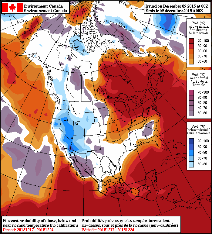
As has been the almost-permanent state of the NAEFS this winter, above normal temperatures are forecast in the 8-14 day range for Manitoba
This large-scale seasonal outlook has been faring quite well so far this year. The end to this year has been exceptionally mild for Winnipeg; perhaps not in magnitude[1], but just through the sheer persistence of moderately above-normal temperatures.
The CPC’s 90-day temperature trace for Winnipeg
Since the beginning of November, there have been just 4 days with below-normal daily temperatures and over the last 90 days, just 16. In a place that’s known for large temperature ranges, it’s impressive to think that over 80% of the past 90 days have been unseasonably warm. This incredible warmth led to the 4th warmest fall on record with a mean temperature 3.0°C above normal. By all accounts, this trend looks to continue and that the remainder of the winter, although likely to have occasional cold spells, will generally be a mild one.
Record high temperatures have been relatively rare over the past 60 days. ↩
A clipper-like system ejecting from the Rockies and set to race eastwards across the Prairies will merge with a low pressure system stalled over Southern Manitoba produce widespread snow over the region Wednesday night into Thursday morning.
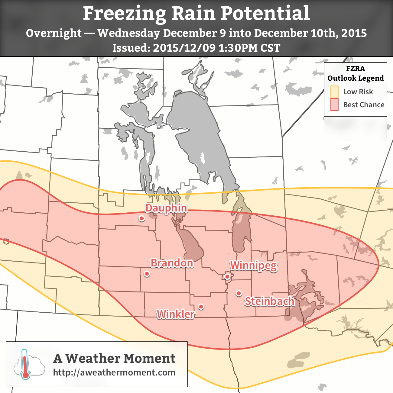
Cloud cover will increase late this afternoon as the incoming low pushes into southern Manitoba, with an area of precipitation spreading eastwards across the region. Initial phases of precipitation will likely be rain or freeing rain before switching over to snow in the second half of the night. Temperatures will hover near the 0°C mark for much of the night, bottoming out at just –1 or –2°C.
The best chance for some freezing rain tonight looks to run from the Parkland region of Manitoba, eastwards across the Interlake & Red River Valely towards the Ontario border. Freezing rain will be limited south of the international border.Freezing rain potential exists, but overall it looks like actual amounts would be fairly limited, with just 1–2mm in the worst-hit areas. This will still be enough to make roads quite slippery, though, so if you’re driving tonight, be sure to take extra care.
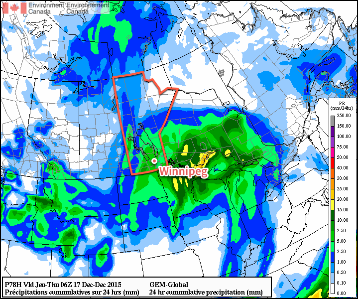
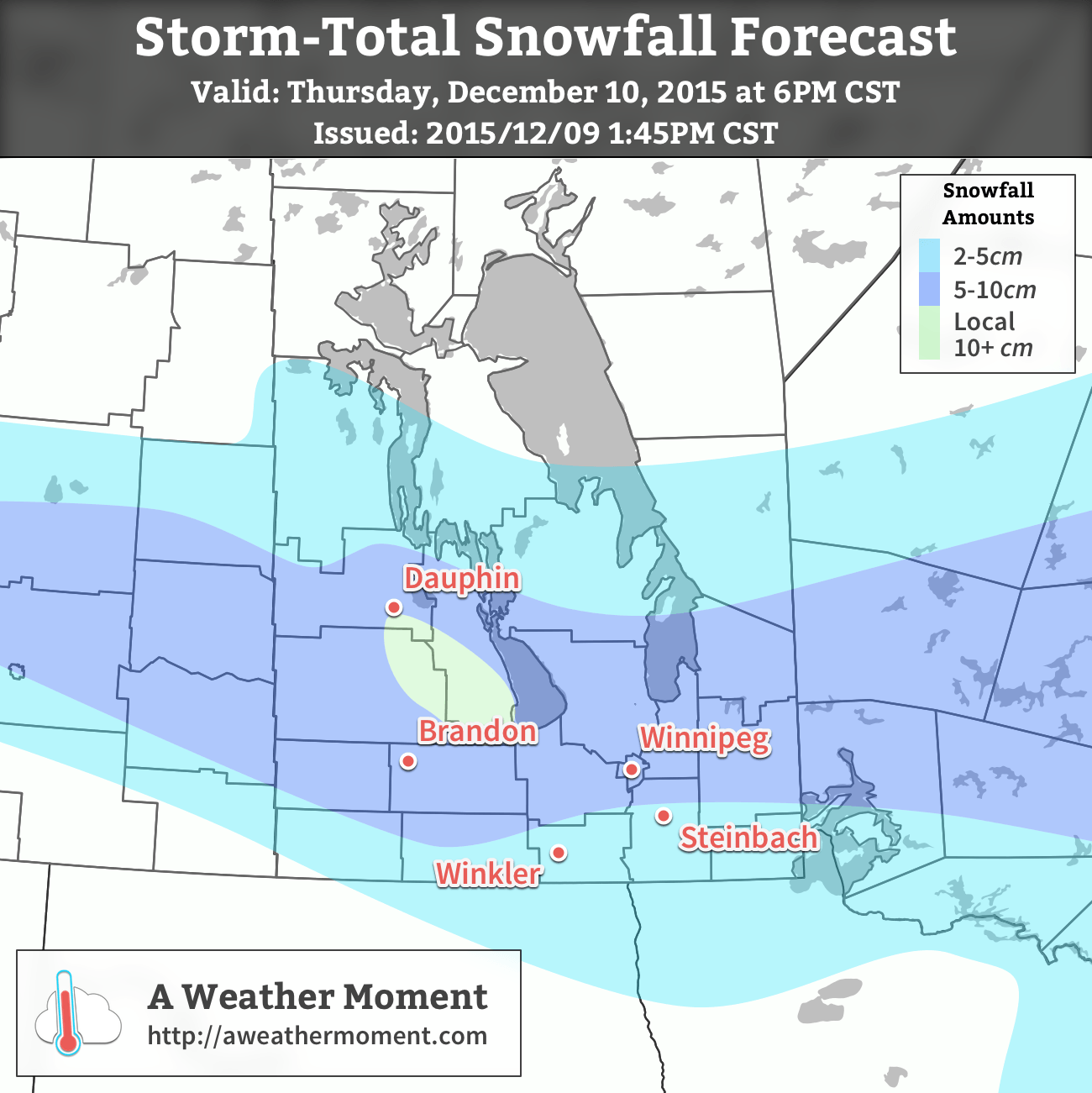
Snowfall will be limited south of the Trans-Canada highway and likely more characterized by a passing band of snow, then a pause before wrap-around snow pushes in on the back-side of this system. Further north, somewhere near the Trans-Canada highway, a west to east band of snow will set up along the northern edge of the low track and will produce the most snow, with general amounts of 5–10cm expected. There will be the risk of amounts in the 10–20cm range for localized areas of upslope flow along the eastern slopes of the Riding Mountains.
A swath of 5-10cm of snow is expected across Southern Mantioba by the end of tomorrow afternoon.The snow will continue falling through much of Thursday here in Winnipeg and the Red River Valley before tapering off in the evening. The snow will be accompanied by gusty northerly winds of 30 gusting 50km/h. Expect the winds to taper off and skies to clear on Thursday night with temperatures dropping to about –6°C.
Friday will be a relatively nice day, however we’ll be stuck between a low pressure system passing to our south and an Arctic ridge to our north. This will keep temperatures limited to around –3°C for a daytime high and bring a chance of some flurry activity through the afternoon as mixed skies develop over the region. Fortunately, winds won’t be too much of an issue. Clouds will likely hang around on Friday night as we head to a low near –7°C.
Long Range
While the cooler temperatures in the forecast may be disappointing to some who have been enjoying this stretch of incredible early-winter warmth, there’s not too much room for complaining as the overnight lows this week are just dipping towards what the normal daytime high is for this time of year.
There’s some uncertainty as to what the weekend will bring, but overall it should be a fairly quiet weekend with seasonal to slightly above seasonal temperatures. Little to no snow is expected.
The NAEFS is forecasting a return to above-seasonal temperatures in the 8-14 day time span.Over the next week, no additional snow is expected, and again, above-seasonal temperatures are expected to build back into the region. The fresh snowpack that will develop after tonight’s snow will likely preclude significant stretches of above–0°C weather, but with daytime highs dropping by the day, it’s nice that the –30°C deep freeze isn’t anywhere to be seen.
Winter will remain absent this week as temperatures remain well above seasonal and our meager snowpack continues to melt.
Today will remain well above normal for early December, as high temperatures across all of southern Manitoba remain near or slightly above zero. In the Winnipeg region, high temperatures are expected to creep just above the freezing mark, although skies are expected to remain mainly cloudy throughout the day. Winds will be breezy from the south at 20-30km/h.
Tuesday will once again be seasonably mild, with high temperatures near or just above freezing. A weak low pressure system will pass through or just south of southern Manitoba, potentially bringing some light rain or snow to some areas. Given the warm temperature profile, any snow that falls is unlikely to accumulate to much. On the other hand, if we see a bit of rain it will only aid the snowmelt.
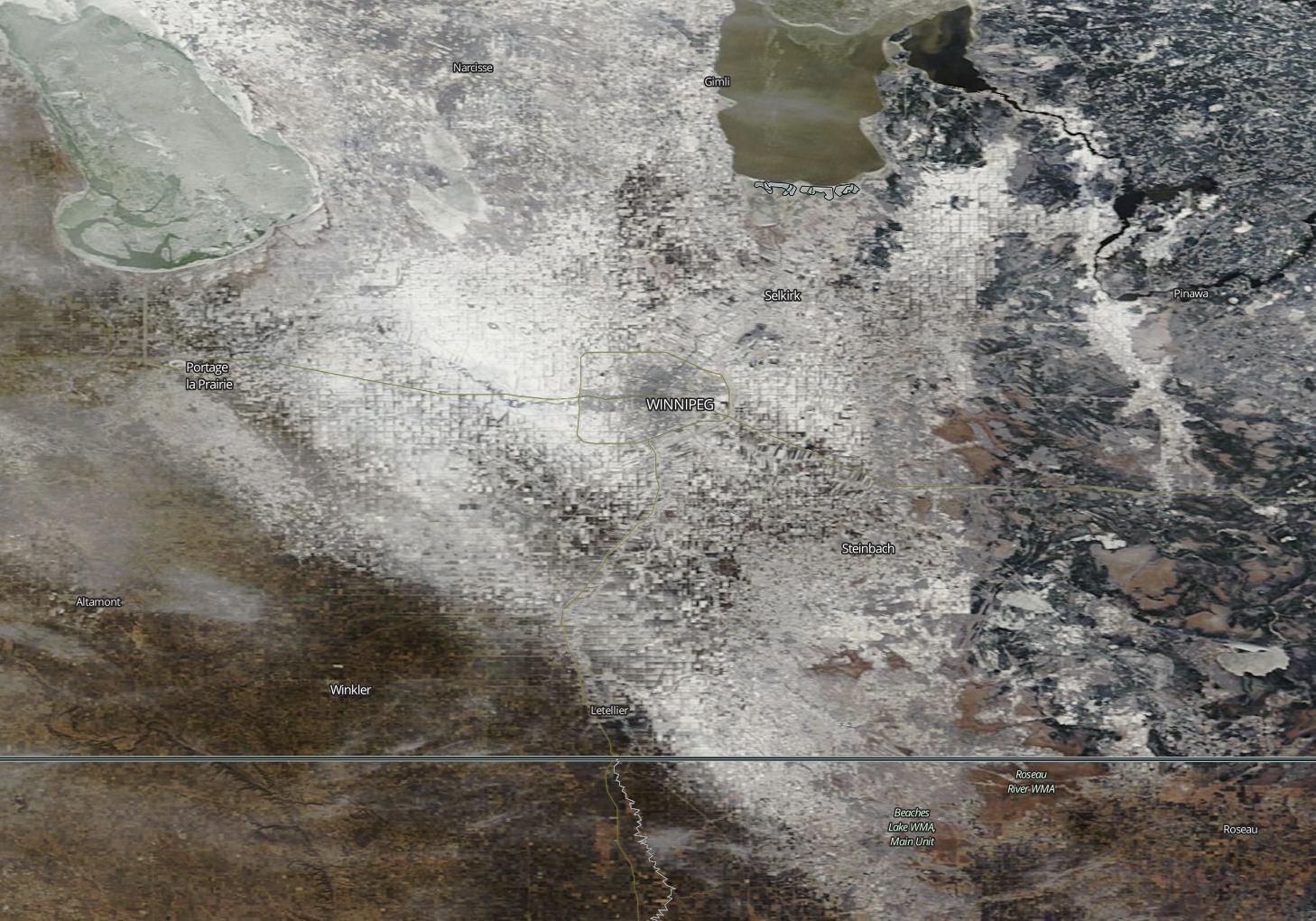
Yesterday’s MODIS imagery clearly shows the diminishing snow pack over the Red River Valley.
Wednesday will see temperatures climb above freezing in southern Manitoba, perhaps well above zero in snow-free areas. In the northern Red River Valley, high temperatures will only be a few degrees above freezing. Winds will be breezy from the south at 20-30km/h.
Long Range
Models continue to show above-seasonal weather for the foreseeable future. However, after this week temperatures may not be quite as warm as they’ve been of late. The average high temperature at this time of year is -8C and the average low is -18C, so don’t expect temperatures to drop much below those values through the first half of December – particularly if we remain generally snow-free. The lack of snow reduces the reflectivity of the surface, allowing more sunlight to be absorbed, generating more heat in the lower atmosphere. So long as we don’t have snow on the ground over much of the southern Prairies, we will maintain a built-in bias toward warm conditions.