Cool Start with a Quick Recovery

After a stretch of summer weather last week that saw daytime highs climbing into the mid-to-upper 20’s, cooler weather has moved into Southern Manitoba behind the weekend’s cold fronts that will start the week off with cooler weather. Temperatures will rebound quickly through what will be a dry & quiet start to the week before things turn more unsettled through the week’s second half.

Today will be the coolest day of the next few with temperatures climbing to just 17 or 18°C as the main axis of cold air behind the weekend’s cold fronts moves across Southern Manitoba. There will be a bit of morning drizzle, but then things should scatter out nicely and Winnipeg will be left with partly cloudy skies through much of the remainder of the day. Winds will be out of the north at around 20 km/h. The clouds will clear out tonight and much of the Red River Valley will see a low near 9°C with light winds.

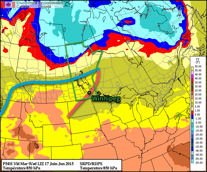
Tomorrow will bring warmer air to the region; daytime highs will be around 5°C warmer than today at the 22–23°C mark. Winds will be light. The day will start sunny, but by the afternoon cloud associated with a weather system moving through North Dakota will spill across the Red River Valley bringing variable cloudiness; in the southern valley it will be overcast through much of the afternoon while further north in Winnipeg it will be a little more variable and a bit later in arriving. Skies will clear overnight as the temperature drops to around 12°C.

Forecast 850mb Temperatures for Wednesday Morning
A warm front moving through on Wednesday morning will bring warmer weather back to Winnipeg.

Wednesday will see warm weather return with daytime highs climbing back to the mid–20’s with just a few clouds. Winds will continue to be fairly light, making for a very pleasant day. We’ll see some cloudiness on Wednesday night with a chance of showers. The temperature will drop just below 10°C or so.

Unsettled Second Half of the Week

Cooler, more unsettled weather will move into the Red River Valley for the second half of the week. Temperatures will drop back into the high teens or low 20’s with an increasing chance of shower activity towards the end of the week. There’s still a fair amount of uncertainty in location, but in general it looks like Thursday will see the shower activity west of the Red River Valley and see it push eastwards for Friday into the weekend. Like this past weekend, it likely won’t be a rainy weekend, but rather one with some chances for periods of wet weather.

Unsettled Weather Returns for the Weekend

After a very pleasant Friday that will see temperatures soaring into the upper 20’s under sunny skies, the weather will turn more unsettled as a complex of low pressure systems move across Manitoba. It won’t be a rainy weekend, but multiple chances for showers or thunderstorms will exist.

Warm but Windy Friday

Today will be a fairly pleasant day across the Red River Valley save for one aspect: the wind. Temperatures will climb into the upper 20’s, topping out at around 28°C with comfortable humidity as dew points settle around 15°C or so. The wind, however, will strengthen out of the south through the day as a low pressure system begins working its way into western Manitoba.

MSLP & QPF from the NAM valid 21Z Friday June 12, 2015
A tight pressure gradient (cyan lines) over the Red River Valley this afternoon will produce strong southerly winds.

The winds will ease up this evening under mainly clear skies. It will be quite a mild night with the temperature dropping to only around 17°C. Some cloud cover will roll into the Red River Valley overnight as a cold front approaches.

Severe Thunderstorm Threat Returns Saturday

Tomorrow will bring a threat of severe thunderstorms to the Red River Valley. A slow-moving cold front will push across the region and is expected to trigger thunderstorms through the afternoon. Where exactly sees thunderstorm activity will depend on exactly how quickly the front manages to push eastwards, which is a bit of an uncertainty at this point.

Most convective parameters look pretty good; CAPE values are expected to climb to around 1500 J/kg as we head to a high near 28°C with a dew point around 17–18°C. This slightly humid air will make it feel more like 33–34°C before the cold front passes through. Ample bulk shear with a 50+ kt jet at 500mb looks favourable, however some synoptic subsidence may occur due to unfavourable jet positioning.

Convective Outlook for Saturday June 13, 2015
A slight risk of severe thunderstorms exists on Saturday June 13, 2015 over the Red River Valley & eastwards.

All in all, there exists a risk for severe thunderstorms along the cold front with main threats of strong winds and large hail. Other modes of severe weather are possible – such as tornadoes or flash flooding – in any severe thunderstorm, however are not expected to be primary threats on Saturday’s storms.

Otherwise, it will be a fairly pleasant day with a mix of sun and clouds and winds out of the south at around 30km/h becoming light as the day progresses. We’ll see some scattered cloud overnight on the way to a low in the mid-teens.

Showers Possible Sunday

Sunday will be a calmer day than Saturday, however the chance for some showers or even a rogue thundershower exists across much of Southern Manitoba as another disturbance ripples over the region. In general, it looks like Sunday will bring mixed to cloudy skies with a decent chance of some scattered shower activity. Temperatures will be cooler with highs of only around 23°C or so in the Red River Valley[1] thanks to the cloud cover and slightly cooler air mass. Skies should begin to break up through the Red River Valley on Sunday evening as temperatures dip to 13 or 14°C again.


  1. We could see temperatures creep higher, to around 25 or 26°C if enough sunshine managed to develop.  ↩

Summer Weather For Second Half of the Week

Beautiful summer weather will be in place over the Red River Valley through the second half of this week with high temperatures in the mid-to-upper 20’s and just an ever so slight chance of an isolated pop-up thundershower.

The next few days will bring beautiful summer weather with daytime highs around the 25–27°C mark. These highs will be a few degrees above the seasonal values of around 23°C or so. Mild evenings are also ahead with overnight lows dipping just to around 14 or 15°C. Winds will also be quite light as a very weak pressure pattern establishes itself over Southern Manitoba.

RDPS Forecast Temperatures for Thursday Afternoon
The RDPS shows temperatures in the mid–20’s over Southern Manitoba on Thursday afternoon.

Both today & tomorrow will see some pop-up cloud through the day thanks to daytime heating. Not much is expected from it, although there may be a few isolated showers this evening into the overnight period as a weak trough pushes through the region. Tomorrow will also bring a very slight chance of an isolated thundershower; by and large it will be a beautiful day with some afternoon cloud.

Friday looks wonderful with temperatures in the upper 20’s and mainly sunny skies and light winds.

A Look Ahead to the Weekend

The weekend is looking more unsettled than the second half of this week thanks to a large low pressure system slowly trundling through the Northern Prairies. Throughout Saturday and Sunday it looks like we may see a chance for some showers as a cold front stalls out over western Manitoba and multiple disturbances ripple northeastwards ahead of it. Temperatures will remain in the low-to-mid 20’s, depending on exactly how much cloud cover we see.

Not a terrible weekend, and hardly a washout; just be aware that there may be some wet weather on and off, depending on where exactly you find yourself!

Investors Group Field - Canada vs. USA - 2014

Beautiful Start to The Week For The First 2015 FIFA World Cup Game in Winnipeg

The first half of this week will bring generally pleasant summer weather to Winnipeg & the Red River Valley. Some showers or thunderstorms may be possible on Monday and/or Tuesday, but mainly south and east of Winnipeg.

Monday

Today will be a beautiful day for the first 2015 FIFA Women’s World Cup game played here in Winnipeg. Skies will be mainly sunny and high temperatures will climb into the upper twenties. Winds will be relatively light from the north-west at 20 km/h or lower. There may be a few passing showers or very weak thunderstorms south and east of Winnipeg, but nothing of particular significance. Overall it will be a very nice day!

Tuesday

Tuesday will see mainly sunny skies prevail once again, with temperatures in the mid twenties over much of southern Manitoba. Winds will be fairly gusty from the north-west at 30km/h gusting up to 50km/h. Similar to Monday, there will be a risk of thunderstorms south and east of Winnipeg. The risk for storms may shift in later forecasts, but presently it appears that eastern Manitoba could see some marginally severe storms, with perhaps some severe hail. We will provide another update if this threat is expected to materialize.

Wednesday

Benign weather looks to return for Wednesday with mainly sunny skies and no precipitation expected. Temperatures will be in the low twenties and winds will be from the north-west at 20-30km/h.

Long Range

Long range models suggest that generally normal to above-normal weather is expected for the next week or two. Frequent passing weather system will bring unsettled conditions from time to time, with a risk of thunderstorms (generally non-severe). We are certainly not in a full-blown summer pattern just yet, but average temperatures continue to warm!