Temperatures Gradually Easing Back Towards the Freezing Mark

Below-seasonal temperatures will continue in Winnipeg this week as temperatures gradually ease back towards the 0 °C mark. The cool conditions and strengthening sun will help flood conditions a bit by gradually evaporating water from the snow pack over the region.

RDPS 2m Temperature Forecast valid 21Z Thursday March 30, 2023
Temperatures will begin a push back towards seasonal values later this week.

The coldest night of the week is now behind us, and the Arctic high responsible for it is gradually shifting off to the southeast. Temperatures will remain cool today with highs once again near -10 °C and lows dipping back to around the -20 °C mark tonight. At least we’ll see plenty of sunshine!

After that, a gradual warm-up will begin as the Polar Vortex begins to weaken over Hudson Bay. This won’t mean a huge warmup for us though, because rather than shifting back into the High Arctic, the Polar Vortex will still stay relatively far south and keep a northwesterly flow over the region. Daytime highs will jump back into the -5 to 0 °C range mid-week with overnight lows in the -10 to -15 °C range.

The region will see some cloud on Thursday as a low pressure system drops out of the Northwest Territories into central Manitoba. Any snow will likely remain well to the north of Winnipeg, perhaps not even moving out of central Manitoba. More sun should return to the region on Friday, but some cloud might work its way into the region as a low passes by to the south of the province.

Long Range Outlook

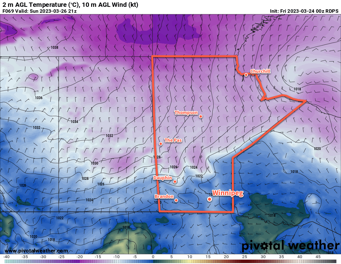
Heading into the weekend, temperatures will finally reach freezing, with highs of above zero even possible. A system passing through the region on Sunday will bring some more cloud to the region along with a chance of snow.

Today’s seasonal daytime high in Winnipeg is 4 °C while the seasonal overnight low is -7 °C.

Relatively Pleasant Spring Weather Ahead

It will be relatively pleasant spring conditions in the Winnipeg area over the next few days as seasonably cool temperatures combine with a mix of sunshine and flurries.

RDPS 2m Temperature Forecast valid 21Z Sunday March 26, 2023
An Arctic cold front will sweep through southern Manitoba to end the weekend, bringing colder weather to start next week.

While the seasonal daytime high for the region has finally climbed above the freezing mark, temperatures in Winnipeg will run just a tad on the cool side over the coming days. Highs will climb very close to freezing today and tomorrow, with the more snow-free urban parts of the city possibly reaching the seasonal high. Overnight lows will dip into the -5 to -10 °C range tonight.

A cold front will swing through the region on Saturday, bringing mixed skies to the region with a slight chance of flurries overnight. Winds will pick up out of the north into the 20–30 km/h range and then ease with the flurries overnight. Overnight lows will dip into the -15 to -20 °C range behind the front.

Temperatures will cool off a bit for Sunday with highs dipping back towards the -5 °C mark. There will be a bit more sun, which means again that some areas will likely see temperatures climbing closer to the freezing mark if they have less snow. Another cold front will swing into the region on Sunday night, ushering an Arctic air mass back into the province along with some more flurries.

Long Range Outlook

Seasonably cool weather will start off next week with overnight lows close to -20 °C and daytime highs in the -5 to -10 °C range. It will start to warm up mid-week followed by a chance for some snow in the second half of the work week.

Today’s seasonal daytime high in Winnipeg is +2 °C while the seasonal overnight low is -9 °C.

Near-Seasonal Temperatures With a Bit of Light Snow on the Way

Seasonal March warmth will stick around in Wininpeg this week, but a passing low pressure system will clip the province tonight and bring some fresh snow to the region.

ECMWF 24-hr. Snow Accumulation Forecast valid 18Z Wednesday March 22, 2023
Southern Manitoba will be clipped by a passing low pressure system on Tuesday night; accumulating snow will fall through most of the Red River Valley and southeastern corner of the province.

An upper ridge over the west coast that has maintained downstream roughing over the eastern Prairies has been the driver behind the cooler temperatures across southern Manitoba over the last several days. Fortunately for us, this feature has begun to collapse and will allow milder air to push eastwards across the Prairies.

Before that happens, though, a compact low pressure system will impact the region tonight. It will spread snow through North Dakota today, then into Southern Manitoba and Minnesota tonight. Much of the heaviest accumulations will remain south of the border, but accumulating snow will still fall across the region. Winnipeg will likely see 2–4 cm of snow by Wednesday morning while amounts increase into the 5–10 cm range to the southeast. The heaviest swath of snow, likely 10–15 cm will from eastern North Dakota into the Kenora, ON region.

Fortunately, winds will stay fairly light through the event, snow blowing snow won’t be too big an issue overnight into tomorrow.

Aside from tonight’s snow, the weather will be quite pleasant with sunny to mixed skies and light winds through much of the week. Daytime highs will hover just on the cold side of freezing, while overnight lows will have a bit more variability. Tuesday night will likely be the coldest night of the week as clear skies combine with the fresh snow cover to drive lows into the -15 to -20 °C range. Other nights this week will likely see low near -10 °C as warmer air begins moving into the region.

Long Range Outlook

A low pressure system passing to the north will bring some cloud and a chance of flurries to the region on Friday into Saturday, then sunshine should return to end the weekend and kick off next week. Temperatures may cool slightly on the back-side of that system, but near-seasonal temperatures should return by mid-week.

And like we’ve mentioned before, daytime highs will vary depending where you find yourself in Winnipeg; more urban parts of the city, especially those close to the downtown core, will likely find plenty of melting and highs near or even a touch above freezing in the coming days as more of the dark surfaces are exposed and able to absorb heat from the strengthening spring sun.

Enjoy the beautiful weather ahead!

Today’s seasonal daytime high in Winnipeg is +1 °C while the seasonal overnight low is -9 °C.

Breezy With Light Snow Today, but Spring Weather Returns Soon

It will be a bit of an unpleasant day in Winnipeg today as breezy northerly winds combine with light snow and cooler temperatures. Nicer weather is on the way soon, though, with plenty of sun and warming temperatures through the weekend.

RDPS 10m Wind Forecast valid 21Z Friday March 17, 2023
Moderate northerly winds will develop over the Red River Valley for Friday afternoon.

Winnipeg will find itself on the back side of a rather potent low pressure system moving from the United States into Ontario today. The region will see breezy northerly winds up to 40 gusting 60 km/h today, driven by the passing low and the approach of an Arctic high from the northwest. Along with that, a weak inverted trough slumping southwards will bring some light snow to the region. These two things will combine to produce some blowing snow in the region, but will mainly be limited to outlying areas and southwards through the Red River Valley. Temperatures will struggle to reach even -10 °C today, and head back into the mid-minus teens overnight. The wind will be stronger this afternoon, then ease overnight.

Skies will clear for Saturday, leaving behind sunny skies for the weekend. Temperatures will climb into the -5 to -10 °C range on Saturday and then into -5 to 0 °C range on Sunday. Overnight lows will sit in the -10 to -15 °C range. Of note, though, is that with full sunshine in mid-March, areas that aren’t just barren snow-covered fields will definitely see temperatures higher than this. It won’t be surprising for many parts of the city to see temperatures in the -5 to 0 °C range this weekend and to see plenty of melting despite the sub-freezing air temperatures.

Long Range Outlook

The start of next week will cool just a bit, then warm up again heading into mid-week. Some snow is possible on Wednesday as a disturbance moves through the region, but it will also likely bring a shift to daytime highs around freezing.

With no major snowfalls on the horizon and several days of sunshine ahead, it will continue to gradually feel more spring-like in Winnipeg; enjoy the pleasant weather this weekend!

Today’s seasonal daytime high in Winnipeg is +0 °C while the seasonal overnight low is -11 °C.