Winnipeg will see increasing cloud today as seasonably mild temperatures move into the region for the rest of the week.
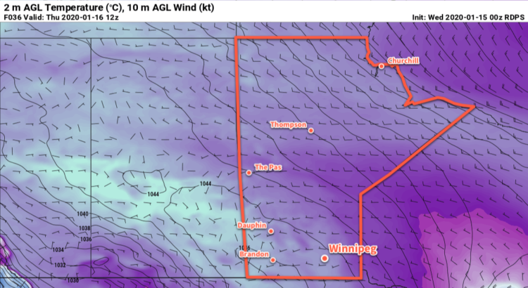
Mild Pacific air has managed to wash over the Prairies over the past few days and will stay put for the next 5-10 days. Through the rest of this work week, Winnipeg will see highs near -7°C with overnight lows in the -10 to -15°C range.
An approaching upper trough will spread clouds into the region today and keep them around through the rest of the week. While a few flurries may be possible over the southwest corner of the province, it doesn’t look like any will make it into the Red River Valley.
Winds will also stay light over the next few days, out of the north today and tomorrow then shifting southerly on Friday.
Long Range Outlook
Another push of mild air will move across the Prairies this weekend, sending temperatures close to the freezing mark by Sunday. A few flurries may be possible with the warming temperatures. Breezy southerly winds are also likely on Saturday.
Today’s seasonal daytime high in Winnipeg is -13°C while the seasonal overnight low is -23°C.
Winnipeg will see a period of windy conditions ahead as milder Pacific air builds into the region.
Conditions will remain seasonably chilly in Winnipeg today with a high near -15°C. The tail end of an Arctic ridge is keeping the cold temperatures in the region today, but a big change is right around the corner. Skies will stay sunny today but winds will gradually pick up out of the south, reaching this afternoon. The winds will keep up through the night with temperatures remaining steady around -14°C. Cloud cover will begin moving into the Red River Valley late overnight.
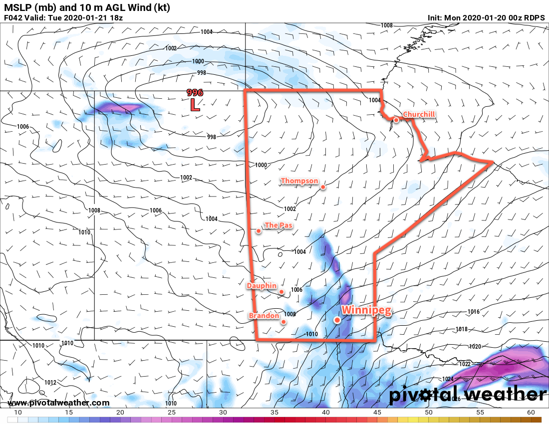
Moderate southerly winds will remain in place over the Red River Valley on Tuesday.
Tuesday will bring mainly cloudy skies to Winnipeg and area with moderate southerly winds gusting up to 60 km/h. Temperatures will continue to climb as the mild Pacific air continues to push towards the region; Winnipeg will see a seasonably warm high near -8°C. The wind will finally ease on Tuesday night as temperatures hover around -8°C.
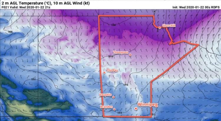
Mainly cloudy skies continue on Wednesday with a mild high near -4°C and light winds. Temperatures look like they’ll drop to a low near -13°C on Wednesday night under mostly cloudy skies.
Long Range Outlook
The rest of the week looks warmer, warmer, warmer! There will be plenty of cloud around as temperatures gradually climb towards the freezing mark. The region will likely see highs near -1°C by the weekend into next week. No significant snow is in the forecast.
Today’s seasonal daytime high in Winnipeg is -13°C while the seasonal overnight low is -23°C.
A developing winter storm system will bring mild temperatures today followed by snow, blowing snow, and colder temperatures on Saturday.
Winnipeg will see mostly cloudy conditions today as temperatures climb to a seasonably warm -8°C. The warmer weather is moving into the region ahead of a potent low pressure system set to track across the Northern Plains later today. Much of the day will bring winds out of the southeast near 30 gusting 50 km/h, but they will diminish through the afternoon as a trough of low pressure moves into the Red River Valley.
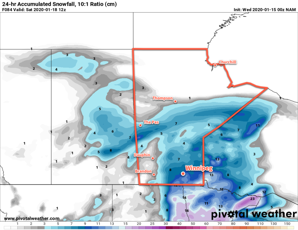
Light snow will move into the region in the afternoon, then intensify through the evening and persist overnight. The wind will pick back up out of the northwest overnight to 30 gusting 50 km/h, combining with the snow to produce areas of reduced visibility in blowing snow. Winnipeg will see close to 10 cm of snow by Saturday morning with higher amounts expected to the southeast.
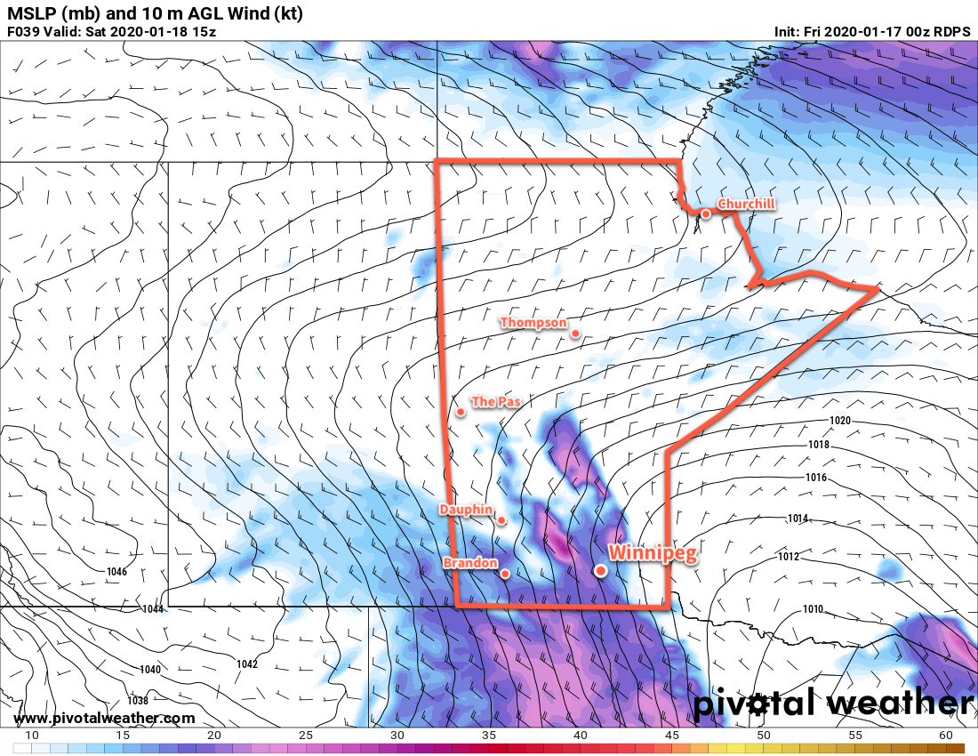
Moderate to heavy snow will develop over southern Manitoba on Friday evening.
Winnipeg will see temperatures remain steady near -17°C on Saturday with light snow continuing through much of the day. The wind will strengthen even more to 40 gusting 60 km/h, producing widespread blowing snow through the Red River Valley. Localized blizzard conditions may even develop, particularly through the western Red River Valley. The region will see about 2 cm of additional snow through the day. Winds will ease slightly to 30 gusting 50 km/h on Saturday night, bringing some improvement to the blowing snow across the region. Temperatures will dip to a low near -20°C on Saturday night.
Moderate to strong northwest winds will be in place over southern Manitoba on Saturday.
Everything will move out of the region on Sunday with diminishing winds and clearing skies. Temperatures will climb to a high near -16°C. Winds will shift to the west through the day as an Arctic high passes by to the southwest. Skies should be clear on Sunday night with a low near -26°C.
Long Range Outlook
For those tired of the cold, the long-range forecast is looking pretty good. Cooler weather will stick around for Monday, but then a large-scale pattern shift will allow milder Pacific air to spread across the Prairies. Much of next week should see daytime highs in the -5 to -10°C range with overnight lows dipping into the minus teens. No major snow events are in the forecast. So if you’re cold adverse, just make it through one more cold snap and you’ll have plenty to look forward to!
Today’s seasonal daytime high in Winnipeg is -13°C while the seasonal overnight low is -24°C.
Winnipeg will see bitter cold settle over the region for the next couple days, but milder temperatures will quickly move back into the region alongside snow on Friday.
Cold air will continue to build into Winnipeg today with highs climbing to a seasonably cold -19°C. Winnipeg and area will see mostly cloudy skies through the day with some light snow likely. By the evening, around 2 to 4 cm of snow will have fallen in Winnipeg with amounts climbing closer to 5 cm along the International border. Winds will pick up to around 20 km/h this morning and then diminish this evening. A potent Arctic high will continue to push into Manitoba from the west tonight, sending temperatures plummeting to a low near -30°C with clearing skies.
Thursday will be a cold day across the region as that Arctic high slides across the region. Temperatures will top out at just -23°C with light winds and sunny skies. Then on Thursday night, the next low pressure system will begin forming over the southern Prairies and Northern Plains. This system will develop as a low pressure centre crossing the Dakotas with a broad inverted trough extending northwards into southern Manitoba. As it approaches on Thursday night, winds will pick up out of the southeast to around 20 km/h. Cloud cover will spread into the region through the night with temperatures rising to around -17°C by Friday morning.
On Friday, milder temperatures will spread into the Red River Valley as the inverted trough slides through. Winnipeg will see a high near -8°C with a southeast wind continuing at 20 to 30 km/h. More snow will develop over the region on Friday afternoon and continue through the night.
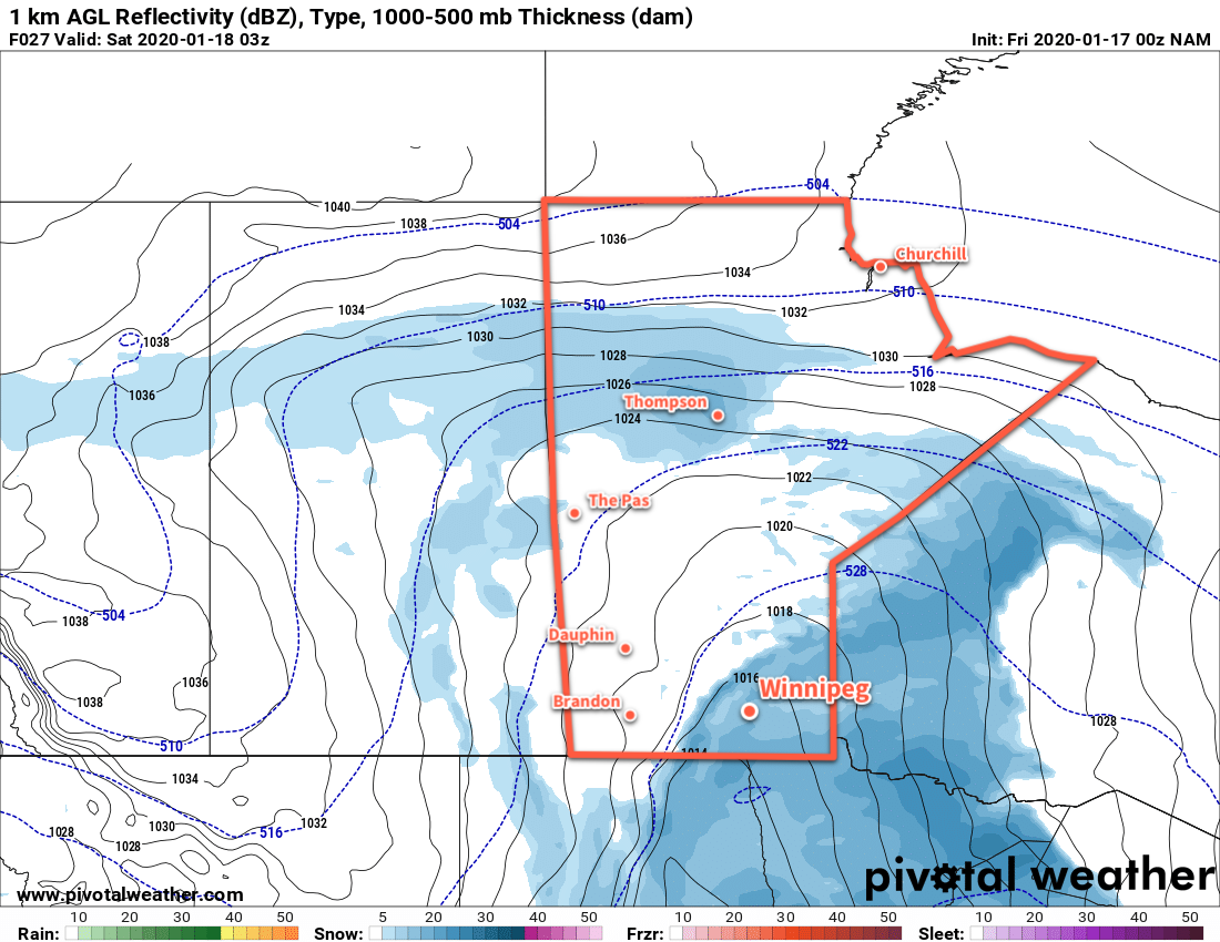
Close to 10 cm of snow is possible across much of southern Manitoba on Friday afternoon through Saturday morning.
The wind will switch to the northwest on Friday night with temperatures dipping to a low near -17°C. Close to 10 cm of snow is possible in Winnipeg by Saturday morning from this system.
Long Range Outlook
The snow will taper off on Saturday with more seasonal temperatures returning to the region. Sunshine will return for Sunday and the start of next week as temperatures dip with highs dropping into the low minus teens. The cold will be short-lived, though, with near-seasonal temperatures expected to return mid-week.
Today’s seasonal daytime high in Winnipeg is -13°C while the seasonal overnight low is -24°C.