The weather this week will start out mild, with temperatures in the mid to upper single digits. However, cooler conditions are on the way later in the week, so enjoy it while it lasts!
Today will be pleasant, with temperatures in the mid to upper single digits over southern Manitoba. Skies will remain mainly sunny, with generally just some upper-level cloud cover passing through. Winds will be easterly at about 20 km/h.
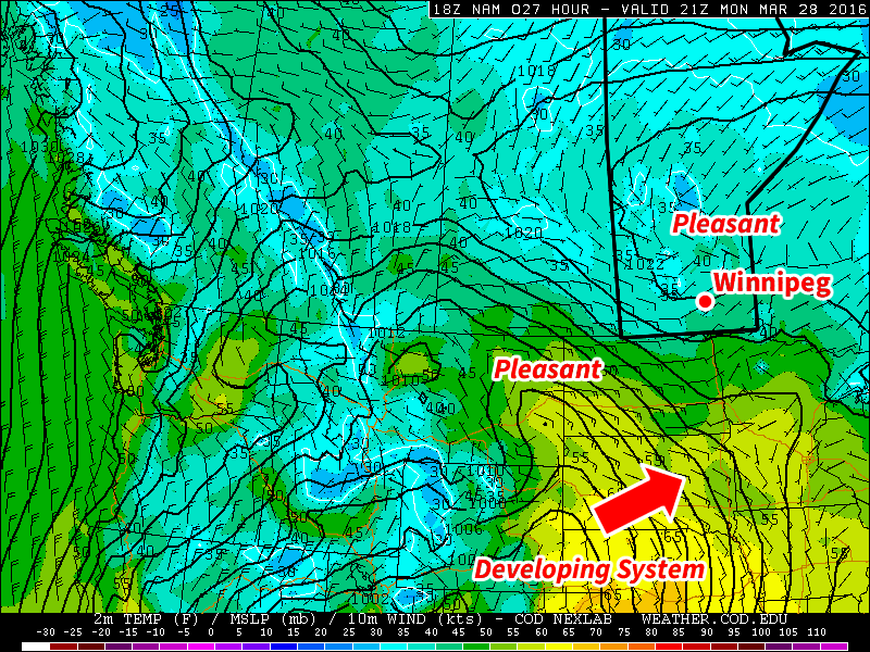
Pleasant conditions are expected early this week in southern Manitoba
Tuesday will remain mild, with temperatures once again in the mid to upper single digits. A weak disturbance will bring a chance of flurries or showers to southern Manitoba; no significant accumulations are expected, but it will be a drearier day. To our south a much stronger system will be passing through the central US Plains, but it is not expected to significantly affect southern Manitoba. Winds will be northerly at 20-30 km/h.
Wednesday will be slightly cooler than temperatures earlier in the week, with highs in the mid single digits. Skies are expected to turn mainly sunny again though, making for a generally nice day. Winds will be northerly at about 20 km/h.
Long Range
The long range forecast is a bit uncertain at this time, but overall it doesn’t look great. Models suggest that a much colder air mass will surge down from the north late this week, bringing with it below seasonal temperatures. This colder pattern is expected to stay with us as we move into early April.
A mixed bag of weather lies ahead with some cloudy & cool conditions transitioning to milder weather with variable cloudiness and a chance of showers.
Today will be a rather cool day with a below-seasonal high temperature of just -1°C as last night’s snow pushes out of the region while a ridge of high pressure builds in behind, bringing moderate northerly winds of 30 gusting to 50 km/h. Much of the day will be mainly cloudy, but by the afternoon, clearing should begin working into the Red River Valley from the north.
Tonight will bring mainly clear skies and an overnight low near -10°C while the northerly winds gradually taper off overnight.
Saturday will bring plenty of sunshine to the region with just a few clouds and light winds. Temperatures will climb to a near-seasonal daytime high of +1°C. Saturday night will see an overnight low near -5°C with increasing cloud through the second half of the night as a weak disturbance moves towards the region from the northwest.
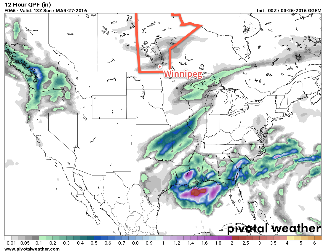
This 12-hour precipitation accumulation valid mid-day Sunday shows weak showers and flurries moving through Manitoba
A chance for showers will return to the region on Sunday as a weak low pressure system brings mainly cloudy skies to Winnipeg and the Red River Valley. Temperatures will climb to around 5°C for a daytime high with winds out of the south near 20 km/h. Skies will remain fairly cloudy on Sunday night with a low near -4°C.
Long Range
A quick look ahead to next week shows milder weather with daytime highs in the mid-to-upper single digits through the first half of the week, but then an abrupt shift back to below-normal temperatures after a major low pressure system moves through the United States mid-week.
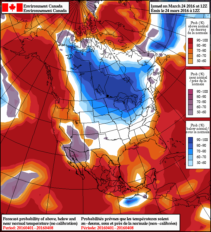
NAEFS 8-14 Day Temperature Anomaly Forecast — Valid April 1 – April 8, 2016
As the NAEFS image shows, for April 1st through April 8th, there’s a near-certainty of seeing below-normal temperatures in Southern Manitoba. At this point, it looks like this will translate to daytime highs near or just below 0°C.
No significant precipitation is expected next week, at least for now. If the track of next week’s major low changes and it shifts further north, well that could be a completely different story!
Winnipeg’s seasonal daytime high is currently 2°C while the seasonal overnight low is -8°C.
A brief reprieve from the cooler temperatures seen of late in Winnipeg is on the way as unsettled weather returns to the region in the second half of the week. Unfortunately, it looks like a return to slightly below-normal temperatures is on the way for the weekend into next week.
Today will be a pleasant day continuing the trend of the past several days. Plenty of sun will be around with just a few clouds throughout the day as temperatures climb to a high near +1°C. Winds will be a little breezy first thing but will diminish by midday as a ridge of high pressure moves into the region. Temperatures will dip to around -6°C tonight for the overnight low.
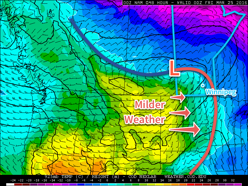
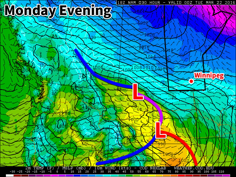
Thursday will see above-normal temperatures return to the Red River Valley as a low pressure system moves into the region from the northwest and spreads milder Pacific air eastwards into the southern portions of the province. This will bring daytime highs up to around +5°C, several degrees warmer than the -2 to 0°C highs of late.
Thursday will also bring moderate southerlies as we often see with the approach of warmer weather. The wind will be relatively calm in the morning, but increase to around 30-40km/h by the afternoon.
As the low pressure system approaches, cloud cover will thicken from just scattered clouds in the morning to cloudy by mid-afternoon. Rain shower activity will move into the Red River Valley through the afternoon period and persist overnight.
The NAM forecast for Thursday reveals a broad low pressure system that will bring milder air into Manitoba.
The chance for precipitation will continue Thursday night as temperatures drop to a low near -2°C. As temperatures drop below freezing, any rain showers will switch to snow flurries.
Friday will see fairly steady temperatures with a daytime high of 0°C a slight recovery from the overnight low. The chance for flurries will persist into the afternoon under mainly cloudy skies. Gusty northerly winds will pick up on Friday morning to 30-40km/h ushering in cooler temperatures that will drive Friday night’s temperature to around the -10°C mark.
Long Range
The weekend looks relatively quiet with near-seasonal temperatures and variable cloudiness.
The bigger weather story on the horizon is a system that will move through southern Manitoba & the northern plains of the U.S. in the second half of next week.
Details of this system are fairly fuzzy at this point, other than saying it will likely be a potent winter storm with a mix of rain, snow and strong wind. At this point, models keep the precipitation in the United States and bring just strong northerlies to our region, but that forecast can easily change over the coming week. The bigger story will be the pattern change that this system will lead into:
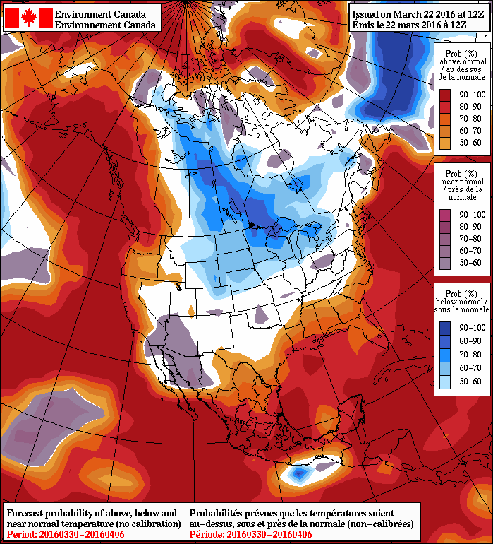
NAEFS 8-14 Day Temperature Anomaly Forecast — Valid March 30 – April 06, 2016
Multiple long-range forecasts are showing a high probability of a brief early-April cool snap with temperatures below seasonal values. With daytime highs in the 0 to -5°C range, it won’t exactly be bone-chillingly cold, but it will be well below the seasonal daytime highs near 5-6°C for that time of year.
Winnipeg’s seasonal daytime high is currently 2°C while the seasonal overnight low is -9°C.
This week will remain on the cool side, but temperatures won’t be far from normal.
Today will be mainly cloudy with temperatures near the freezing mark. The main weather feature in the short-term will be a low pressure system passing to our south today. This system is expected to spread some light snow throughout southern Manitoba this afternoon into this evening. Accumulations in the Winnipeg region aren’t expected to be more than one or two centimetres, but areas closer to the U.S. border could see somewhat larger amounts. Winds will be from the east at 20-30 km/h.
A low pressure system passing to our south will bring a chance of flurries today
Skies are expected to gradually clear on Tuesday as a dry north-easterly flow develops over southern Manitoba. Temperatures are expected to be just below zero in most areas, which is slightly below seasonal for this time of year. Winds will be north-easterly at 20-30 km/h.
Wednesday will be mainly sunny, with temperatures again just below the freezing mark. A surface high pressure system is expecting to reside over southern Manitoba, allowing for those sunnier skies and light winds.
Long Range
The long range forecast shows generally seasonal to below-seasonal weather through the end of March. There are no large warm-ups currently in the forecast.
Winnipeg’s seasonal daytime high is currently 1°C while the seasonal overnight low is -9°C.