Winter Settles In

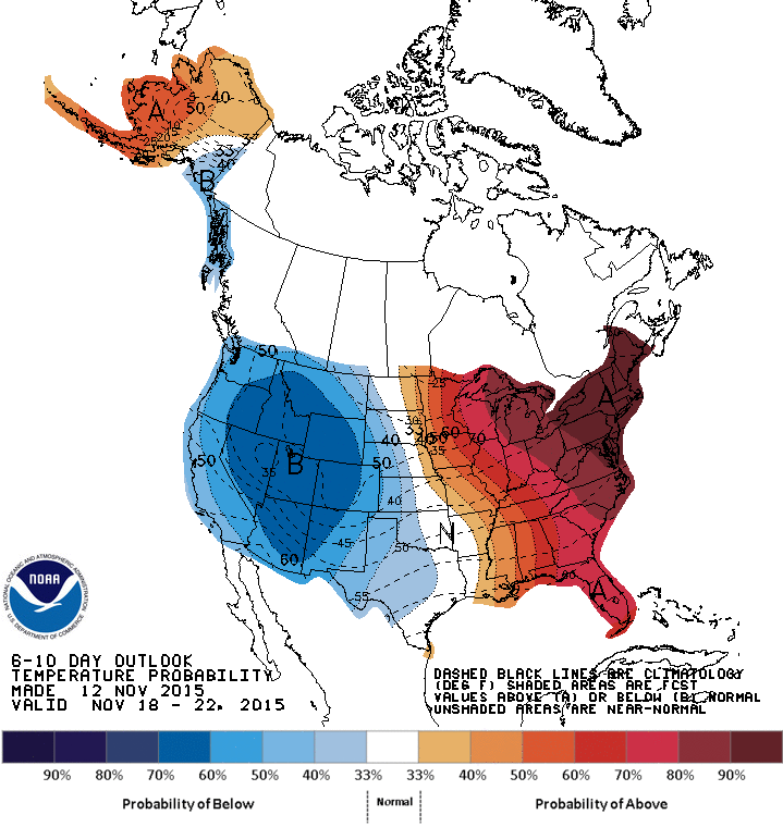
After the blustery entrance of winter that saw the first substantial snowfall of 2015 in the Red River Valley alongside winds gusting anywhere from 70 to 90 km/h, significantly cooler weather will settle over the region for the coming days. There good news is that temperatures won’t be too far from seasonal for this time of year, despite being nearly 15°C colder than they were earlier this week.

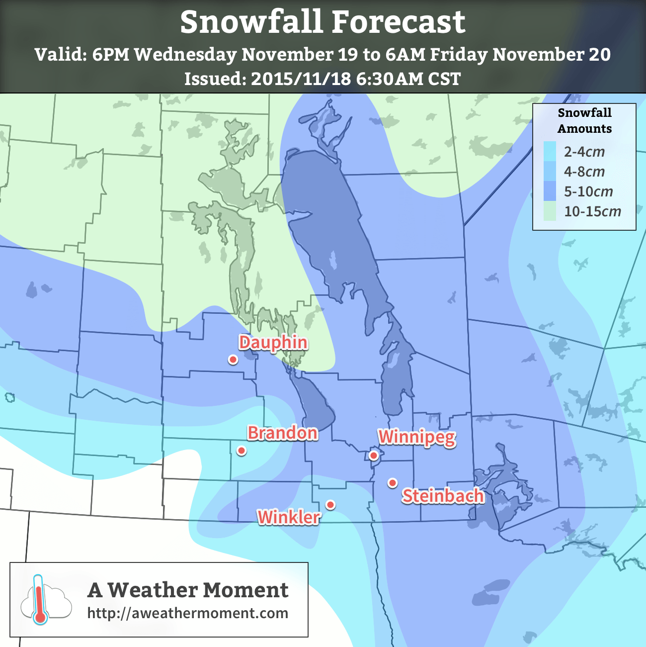
Mainly cloudy skies will persist through the Red River Valley today with northwesterly winds of 20–30 km/h with gusts up to around 45–50 km/h. The snow we’ve seen the past couple days is over, but a couple light flurries can’t be ruled out through the day; that said, it wouldn’t be much that will accumulate. The only threat of accumulating snow will come as the winds align and lake-effect snow develops off of Lake Manitoba and Lake Winnipeg. Who will see the snow will depend on exactly what the wind direction is, and at the time it looks like Winnipeg may see a bit of snow from these features. Daytime highs will be slightly below the seasonal normal of –3°C, topping out at –5°C or so.

RDPS 12hr. Precipitation Accumulations
The RDPS precipitation totals for today clearly show the two bands of lake-effect snow off of lake Winnipeg & Lake Manitoba.

The clouds will start breaking up tonight as we head towards a low of –12 to –15°C.

Saturday brings less wind, a little less cloud, but more cold. Mixed skies will preside over a day that sees temperatures climbing to –6°C or so and calm winds. The cooler, calmer weather is thanks to a ridge of high pressure that will be sliding through the area. Despite the cooler weather, the lack of significant winds and a bit of sunshine may end up making Saturday a relatively pleasant day overall. Expect a low near –12°C under partly cloudy skies on Saturday night.

GDPS 12hr. Precipitation Accumulation valid midday Sunday through Sunday evening.
The GDPS is showing a large area of snow pushing through Manitoba on Sunday afternoon and evening.

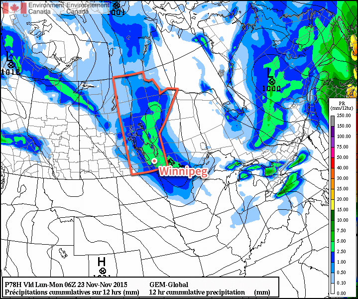
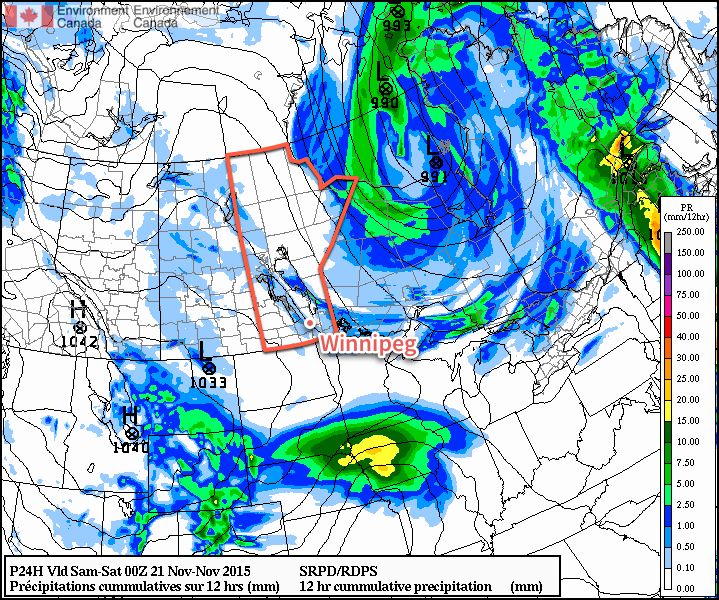
Sunday’s weather will be largely influenced by the approach of the next low pressure system to impact Winnipeg and the Red River Valley. Starting fairly early in the morning, winds will begin picking up out of the south and will strengthen to around 30–40 km/h by midday.[1] Cloud cover will push in from the northwest while temperatures climb close to the freezing mark. By later in the afternoon, it appears that there will be a fairly good chance that the Red River Valley will see an area of snow push through, possibly dropping another couple cm over the region.


  1. At this point, winds of 30–40 km/h seem reasonable, however if a little more cold air damming occurs in the Red River Valley, which will dependent on the exact track and strength of the ridge of high pressure moving through on Saturday, then stronger winds of 40–50 km/h could possibly develop. We’ll keep an eye on it as the weekend progresses.  ↩

Winter Arrives

Environment Canada made headlines with the special weather statement for Winnipeg issued Monday with a referential start: winter is coming. And how.

Today will mark the beginning of a harsh slide into winter after a essentially a month of temperatures well above seasonal for this time of year. The change in the pattern will be brought courtesy a rather peculiar weather setup that will see a relatively weak Colorado Low moving north through Minnesota into Northwestern Ontario merge together with an Alberta Clipper quickly moving eastwards across the Prairies. Each system is moderately potent in their own right, but when combined, they will form a new storm system that will rapidly intensify, driving strong northwesterly winds through the province alongside the first significant snowfall for many regions of Southern Manitoba.

Today will start deceptively. Relatively light winds and temperatures climbing towards 5 or 6°C will give a false sense of security betrayed only by the increasing cloud cover that will build in through mid-day into the afternoon. Some light rain will develop over the Red River Valley this afternoon, which will mark the end of our above-seasonal temperature streak and usher in winter. As the rain moves into the region, winds will pick up out of the northwest to around 50km/h sustained with gusts as high as 70–80km/h. The rain will switch over to snow sometime in the evening and likely begin piling up fairly quickly as the strong winds rapidly cool the ground and other surfaces.

The strong winds and snow will persist through tonight as temperatures dip down towards –3°C or so as colder air begins filtering into the region. With snow piling up and such strong winds in place over the Red River Valley, it’s quite likely that driving conditions become quite poor as roads freeze, become ice covered, and see reduced visibility in blowing snow.

AWM Snowfall Forecast issued November 18, 2015
AWM Snowfall Outlook issued November 18, 2015

Thursday will continue to bring light snow and strong winds to the region as temperatures remain around –4°C or so. The winds will be a bit lighter than at their peak, but will likely remain near the 40 gusting 60km/h mark through much of the day before beginning to taper off in the evening. Overnight, other than some lake-effect snow streaming southeastwards off of Lake Winnipeg, there’s likely to be just a few flurries lingering in the region. Temperatures will dip down to –6°C for the overnight low.

In general, around 5–10cm of snow is likely to fall with this system through southeastern Manitoba, the Red River Valley and northwestwards into Parkland Manitoba. Exact amounts will depend on the timing of the change-over from rain to snow and how quickly the snow begins accumulating instead of melting on the ground.

Friday will be a mainly cloudy day with just a very slight chance of light, scattered flurries. Temperatures will recover only a degree or two from the overnight low with highs around –4°C. There may be a few clear breaks through the Red River Valley on Friday night, but overall there will still be a fair amount of cloud as temperatures head towards an overnight low near –10 or –11°C.

Colder Weather Continues Through The Weekend

The cooler weather, which while a significant drop from what we’ve been experiencing is, in actuality, just a couple degrees below seasonal values for this time of year, will persist through the weekend.

NAEFS 8-14 Day Temperature Anomaly Outlook valid for November 25 to December 2, issued 12Z November 17, 2015
The NAEFS is showing a trend towards seasonal temperatures for the remainder of November.

Daytime highs around –5 or –6°C will be in place over Winnipeg & the Red River Valley this weekend, with a chance of some more flurries on Saturday improving to sunnier fare on Sunday. Overnight lows will be in the low minus single digits. So, while it may be a huge change from the weather we’ve been having, we’ll be shifting to more seasonal weather for the end of November.

Grey Skies Return on Monday

Grey and drizzly weather return today as a surge of moisture from the south generates an area of low cloud over southern Manitoba. It looks like we may see the sun again by midweek.

Monday will be overcast with periods of drizzle as a surge of moisture generates low cloud over southern Manitoba

Monday

Today will be a grey, dreary day in southern Manitoba. A strong push of low-level moisture from the south will generate a broad area of low-cloud, bringing periods of drizzle to southern Manitoba throughout the day. Temperatures will remain relatively mild, in the mid single digits, but with the drizzle and wind it won’t feel particularly comfortable. Wind speeds will be gusty, at 30km/h gusting to 50km/h, out of the south-east.

Tuesday

Tuesday will see generally cloudy skies stick around in southern Manitoba, but we may see some clearing by late in the day. The flow will shift to westerly on Tuesday, allowing a drier airmass to move into the region. However, it doesn’t look like this drier air mass will arrive in time for us to see clear skies before sunset. Winds will be westerly at 20km/h with temperatures in the mid single digits.

Wednesday

We should finally see sunnier conditions on Wednesday as we sit between two approaching low pressure systems. Current forecast models suggest we’ll remain in a dry airmass for most of Wednesday, before the risk of precipitation increases again on Wednesday night. Winds should generally be light, with temperatures in the mid single digits.

Long Range

It looks like we’ll see a fairly stark change in the weather on Thursday as a powerful cold front ushers in a more arctic-like airmass. Very strong winds are expected on Thursday in the wake of this front along with decreasing temperatures. Unfortunately, we may see some accumulating snow with this system, though it’s too early to say how much can be expected. It still appears that the overall pattern will remain above normal for the foreseeable future, but as we move further into the winter season snow and cold are inevitable.

Weather Warms For A Beautiful Weekend

Temperatures are set to soar well above-seasonal this weekend as another blast of mild Pacific air surges eastwards across the Prairies.

Today will be the least pleasant of the coming few days in Southern Manitoba. A warm front pushing eastwards across the region will begin pushing warmer air into the Red River Valley, but alongside that prospective warmth will come those pesky southerly winds, picking up to around 40km/h by the afternoon. Those brisk winds will make our high of 3 or 4°C feel quite a bit cooler than that.

On the bright side, the sun will make an appearance for much of the day. While there may be a bit of cloudiness remaining this morning, particularly south of Lake Winnipeg where some lake-effect drizzle or flurries will be tapering off, a drier flow pushing into the region will clear skies and bring us plenty of sunshine for the afternoon.

Expect temperatures to dip to around 1°C tonight with a few clouds moving through and breezy conditions continuing.

RDPS Surface Wind Forecast
Windy conditions are expected throughout portions of the Northern Plains and Manitoba this afternoon.

Saturday will be a very pleasant day with mainly sunny conditions and much lighter winds than today. Temperatures will climb to around 8°C this afternoon, about 9°C above the seasonal average daytime high of –1°C. Temperatures will drop to around +1°C tonight with fairly cloudy skies developing. There are some hints that fog or drizzle may form over the Red River Valley on Saturday night, so we’ll keep an eye on that.

Sunday will see morning cloud dissipate alongside any fog or drizzle that manages to develop and be left with a sunny afternoon and temperatures soaring over 10°C above normal to around 10°C. Winds will not be much of an issue, making it an absolutely beautiful day.

Mild Weather Continues

As we continue to push further into meteorological winter, we generally expect the effects of a strong El Niño to become more pronounced, and so far, that’s exactly what we’ve been seeing as temperature anomalies intensify across North America.

CPC 6-10 Day Temperature Anomaly Forecast
The CPC 6-10 day temperature anomaly forecast continues to lean towards above-normal temperatures for Winnipeg through the end of next week.

The warm weather is expected to continue for our region, with above-normal temperature anomalies are continue to be forecast for the region. Despite the fact that our average daytime high continues to fall, daytime highs on the positive side of freezing continue to persist in the long-range forecast.

Other than temperatures, little precipitation is in the forecast as well; despite multiple systems tracking through the region, the bulk of precipitation is expected to our north and south, leaving us with some windy days, but still looking for the first big snowfall. That said, the longer we can keep the snow off the ground, the longer our above-zero highs can persist!