Typhoon Dujuan formed earlier this week on Wednesday in the middle of the Pacific Ocean and continues to barrel westward toward northern Taiwan and the eastern shores of China.
The Western Pacific typhoon season, which is running above average this year with already 21 named storms, has primarily affected Japan, China, and the Philippines. The average number of named storms for a full season averages around 25 storms (May until late October is peak Western Pacific storm season, but storms can form outside this period). Dujuan currently sits about 1200km east of Taiwan shores and is still undergoing intensification. As of Friday night the storm had sustained winds of 167km/h, gusting up to 200km/h and had an estimated central pressure of 960mb. The Japan Meteorological Agency forecasts that by the end of the weekend it will have intensified to a high end category four equivalent storm as it approaches Taiwan. With sea surface temperatures in the order of 30°C and shear values between 5-10kt their forecasts for a powerful typhoon is warranted.
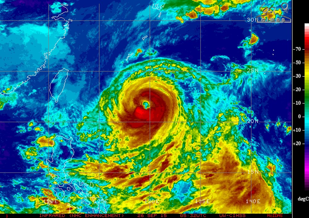
Infrared satellite imagery of Dujuan on Friday night shows very cold tops on the south side of the eyewall and an eye that has cleared out nicely. (Source: UW-CIMSS)
Latest 00z forecast models on Friday night had the storm brushing northern Taiwan and then pushing onto China’s mainland by Monday night near the city of Wenzhou. With a track like this, northern Taiwan would take the brunt of the storm with severe storm surge, high winds and heavy rain, while the threat to China wouldn’t beas major they would still see extremely heavy rainfall with the remnants. However, it must be noted that there is much uncertainty about the specific track still and the storm could deviate from current model forecasts.
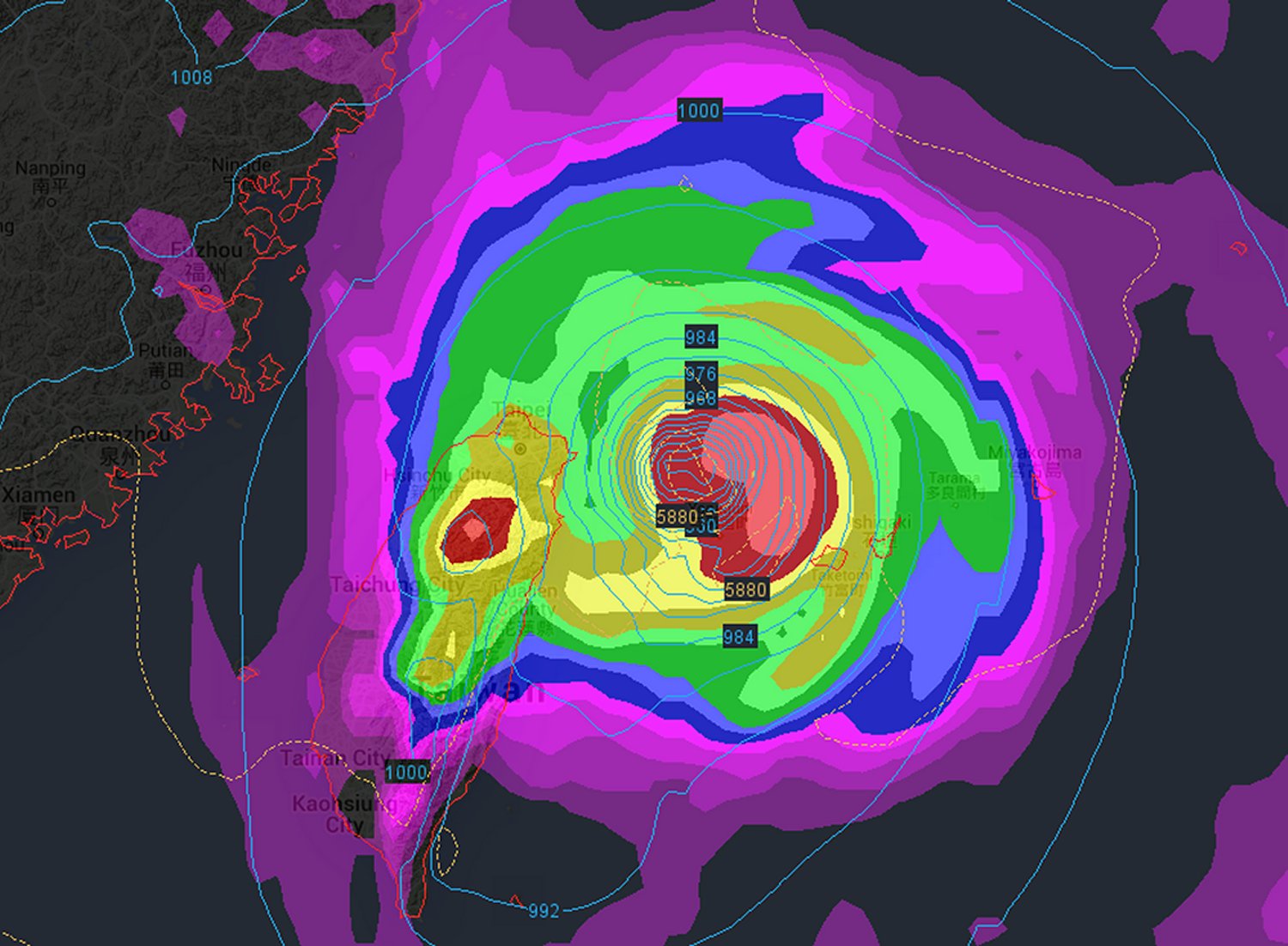
Only one of the numerous forecast models’ output for Dujuan. This one from the 25/12z ECMWF – brings the storm down to 935mb near northern Taiwan. (Source: Wunderground)
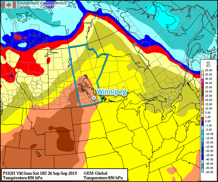
A beautiful end of week is on tap as temperature soar well above seasonal values with plenty of sunshine on tap. Things will take a slight turn for the end of the weekend as a cold front slumps through the Red River Valley and ushers in a windy return to temperatures that are…just slightly above seasonal values.
Today and tomorrow will be gorgeous days with daytime highs in the mid-to-upper 20’s soaring more than 10°C above seasonal for this time of year. The wind will be fairly noticeable, however, increasing each day out of the south to around 30–40km/h, with some gustiness particularly on Saturday. Expect overnight lows in the low to mid-teens.
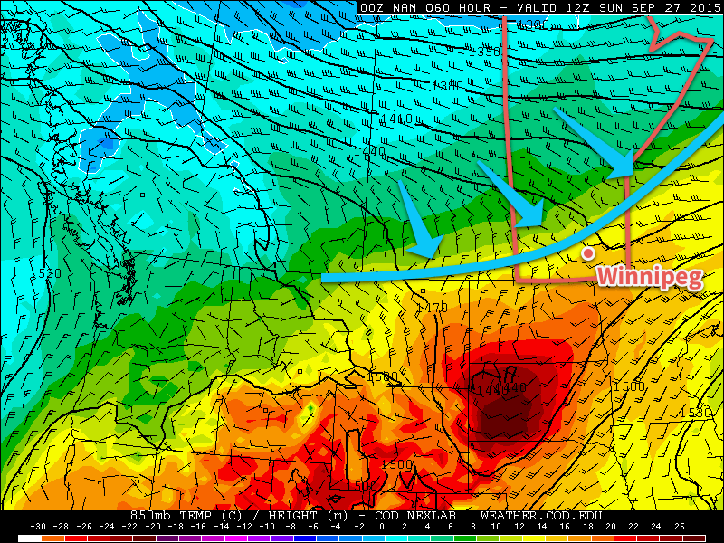
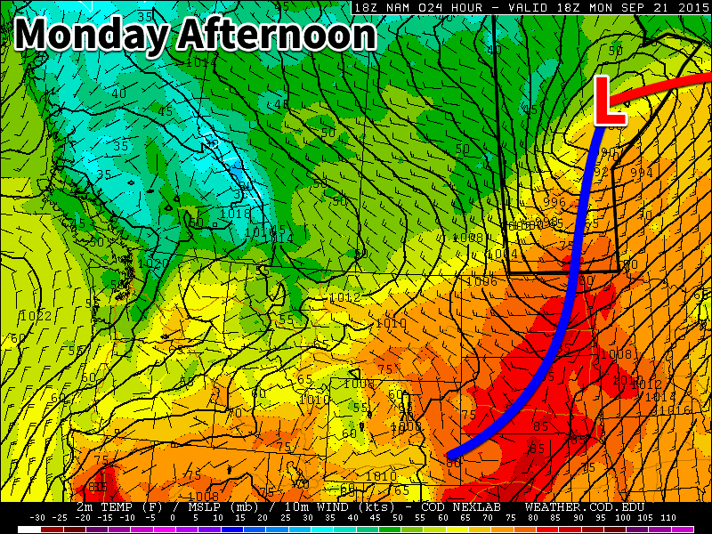
Shown here in the NAM forecast for 850mb temperatures, a cold front will be advancing through Manitboba on Sunday morning.
A cold front will slump through the Red River Valley on Saturday night, shifting the winds to the northwest late overnight and bringing a slight chance of showers to the region. Overall, the frontal passage looks to be fairly dry with little precipitation expected.
This will lead to a breezy Sunday with a high that, while still above seasonal, will be quite a bit cooler than the prior couple days, likely settling near the 20°C mark. While the morning cloud will clear out, some variable cloudiness will likely develop as things warm up a bit in the afternoon, leading to a bit of a mixed sky through the day. The low temperature will dip into the mid-single digits on Sunday night.
Before that happens, though, we’ll have two beautiful late-September days to enjoy!
The Red River Valley had an abrupt cool-down Monday evening as a dry, but quite potent, cold front pushed across the Red River Valley, dropping some of the warmest temperatures in the country by 10°C in a matter of an hour and returning the region to far more seasonal temperatures. The foray into fall will be brief, however, as warmer weather is already set to build back into the region over the coming days.
Today will be a bit of a mixed day; skies will be cloudier than not, but fortunately things should remain fairly dry with a high temperature near 17°C. The wind will be noticeable, though, as it builds out of the east through the morning to around 30–40km/h with some gustiness on top of it. The cloud will stick around through the night with an increasing chance of showers overnight.
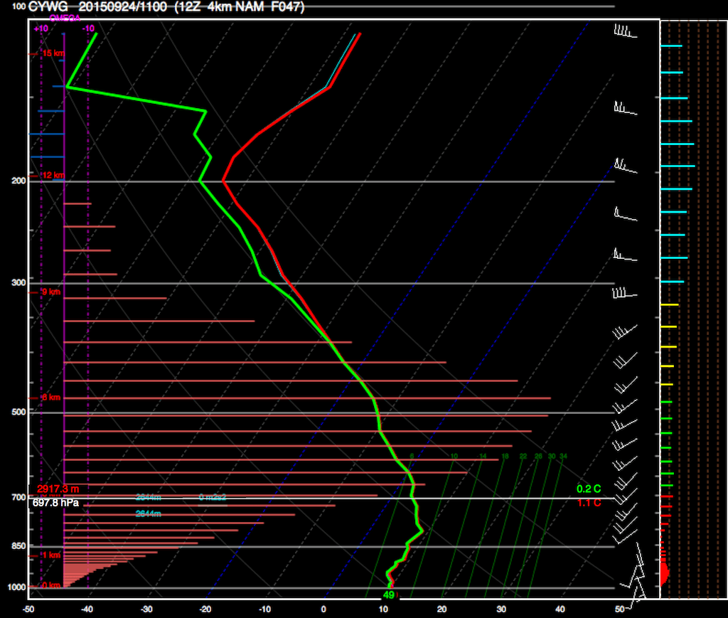
This forecast sounding for Winnipeg from the 4km NAM shows tremendous vertical velocities on Wednesday morning.
There’s uncertainty to how intense the shower activity will be and whether or not there will be any thunderstorms over the Red River Valley. At this point, the weather model most in favour of thunderstorm development has been the NAM model from the NWS. It’s difficult, though, to fully believe its output given some of the parameters it has been outputting.
Shown above is a forecast sounding from the 4km NAM model for early Wednesday morning. It reveals a high likelihood of thunderstorms, however what’s more important is the omega values it’s producing. Omega (Ω) is a measure of how fast air is moving up or down in the atmosphere, and often has values in the range of ±5–10µb/s. In strong summer-time convective situations, Ω can have values in excess of –60µb/s. The 4km NAM is producing values in excess of –160µb/s, which seems a bit physically implausible. The NAM follows similar ideas, which gives me hesitation to jumping on board the thunderstorm train.
Ultimately, any precipitation over our region is part of a secondary area of lift enhanced by confluence near a deformation zone of a larger system passing to our southeast. Because of that, it seems quite likely that we’ll see some shower activity this evening or overnight with a slight chance of an isolated thunderstorm or two. The more extreme solutions being presented by the NAM seem misplaced given the large-scale dynamics present. There’s always an off chance that the model that seems way out to lunch is correct, but I wouldn’t bet the farm on it at this point.
Thursday will be a bit of a damp day with cloud and scattered showers sticking around for at least the first half of it. Any remaining precipitation will taper off through the afternoon, but the cloud looks like it will stick around through the overnight, sustained by another approaching area of lift. Expect a high in the upper teens on Thursday with an overnight low in the low teens. Fortunately, the winds will be fairly light.
Warming Trend Begins on Friday
Friday will see the heat return to Winnipeg & the Red River Valley as a warmer air continues to push its way into Southern Manitoba. Winds will gradually pick up out of the south to around 30km/h in the afternoon as the temperature climbs into the low 20’s, some 5–8°C above seasonal highs for this time of year. The cloud will gradually push out of the region through the day, likely leaving us with more sun than cloud in the afternoon, making for pleasant fall conditions.
Overnight lows will fall just to the mid-teens on Friday night.
Beautiful Weekend Ahead
This weekend looks positively beautiful for late September. Saturday looks to be a fairly sunny day with highs climbing into the mid- to upper–20’s with winds gradually tapering off. It looks like there will be a chance for some rain or thunderstorms over lake Winnipeg (mainly the South Basin & the Narrows) and areas east through the overnight period as a cold front pushes into the region.
The GDPS is forecasting a surge of warm air pushing into Manitoba on Saturday, shown by this 850mb – about 1.5km off the ground – temperature forecast.
Sunday looks cooler than Saturday with a slight chance of morning showers, but all in all it should still be a pretty nice day. Mixed skies will accompany a high in the low–20’s, still some 5–10°C above normal. Winds don’t look to be too much of an issue either. All in all, for this late in the year, the weather this weekend looks fantastic.
Next week has the potential to be more unsettled, as many models are showing a train of disturbances pushing across the Northern Plains of the U.S. These systems can often bring rainy weather to Southern Manitoba, but at this point it’s far too early to say one way or another how things will go. For now, enjoy the rest of the week and the coming warmth!
We’ll see one more warm day today before a cold front rolls through late this afternoon. Cooler weather is on tap after today, but temperatures will remain near seasonal.
A cold front will move through southern Manitoba on Monday afternoon, ushering in cooler weather
Monday
Today will see a shift in our weather as a cold front moves through late in the day. This cold front will drop temperatures from the upper twenties down into the teens by the evening. Winds will also shift from being southerly in the morning to westerly or north-westerly following the frontal passage. No precipitation is expected as this cold front passes due to the lack of moisture ahead of it. Temperatures will fall rapidly on Monday night in this cooler air mass, with lows by Tuesday morning only in the single digits.
Tuesday
Tuesday will see much cooler weather than Monday, but temperatures will remain near seasonal. Highs on Tuesday are expected to be in the mid to upper teens under mainly sunny skies. Winds will be breezy from the west. No precipitation is expected.
Wednesday
Wednesday will see this cooler weather pattern continue with high temperatures only in the mid teens. Skies will be mainly cloudy and there will be a chance of showers throughout the day. Winds will be light and from the east.
Long Range
The long range forecast suggests that our weather will generally remain at or above seasonal values for the remainder of September. You can expect to see a few more warm-ups before chillier fall weather is here to stay.