After an early blast of fall-like weather earlier this week, Winnipeggers will be pleased to hear that summer will quickly return to Southern Manitoba.
Wednesday
24°C / 13°C
Warming up with some afternoon cloud
Thursday
27°C / 15°C
Mainly sunny. Off-chance of a late-day shower
Friday
23°C / 9°C
Morning cloud with gradual clearing
There’s little to say about the weather heading our way the next few days. Today will be a pleasant day with highs near 24°C with some afternoon cloud and winds gradually increasing out of the south to 20–30km/h. Temperatures will dip to around 13°C tonight with partly cloudy skies.
Tomorrow will be a warmer day across the region with highs near 26 or 27°C. A cold front will begin working its way through western Manitoba through the day and push into the Red River Valley overnight. Despite ample surface moisture, stronger mid-level dynamics remain further north in the Interlake, so it’s likely that the front will be relatively unimpressive through the Red River Valley, but there will still be an off-chance of some isolated strong thunderstorms. In general, showers will be much more likely along the front as it pushes eastwards. Temperatures will drop into the mid-teens Thursday night in Winnipeg with a small chance of showers.
Friday will be a cooler day thanks to the cold front that will push through on Thursday. Highs will be limited to the low 20’s and the day will start off with cloud that will then gradually clear throughout the day. The low on Friday night will drop back into the high single-digits.
Southern Manitoba will see its first blast of fall-like weather as gusty northwesterly winds draw cool air southwards over the region. Fortunately, it doesn’t look like the cold weather is here to stay and seasonal temperatures are expected to return by week’s end.
Monday
15°C / 7°C
Mainly cloudy; windy and cool with lake-effect showers possible
Tuesday
19°C / 10°C
Mainly sunny
Wednesday
23°C / 15°C
Mainly sunny
Today will be an unwelcome day for late August as abnormally cold air will move into the province behind the low pressure system that brought 20–40mm of rain to Winnipeg & the Red River Valley Saturday night into Sunday morning. Brisk northwesterly winds to around 30–40km/h will usher in this cooler air and will restrain our daytime high to just the mid-teens. Additionally, the abnormally cool air aloft and favourable wind profiles will combine to produce lake-effect showers that will spread southeastwards towards Winnipeg.
Forecast 850mb temperatures for this afternoon show a trough of cold air anchored over Manitoba.
Given that, occasional showers are likely in Winnipeg although due to the nature of lake-effect precipitation[1] the precise wind direction will determine whether or not the showers find their way into Winnipeg or whether they end up just north or just south of the city.
The clouds will clear out tonight as temperatures drop to around 7°C.
Tuesday and Wednesday will trend towards seasonal weather. Winds will be relatively light both days while the Red River Valley enjoys mainly sunny skies. Temperatures tomorrow will climb into the high teens while highs on Wednesday will reach the low 20’s. Lows on Tuesday night will bottom out around 10°C while Wednesday night sees more seasonal lows in the mid-teens.
Seasonal End to the Week
Looking ahead to the second half of the week, summer weather returns in full swing. Temperatures heading through the end of the week will see daytime highs in the mid–20’s with overnight lows in the mid-teens. The weather looks fairly dry until Friday when a weak cold front pushing across the province brings the chance for some shower or thundershower activity.
Lake-effect precipitation extends in a very narrow band along the direction of the wind. ↩
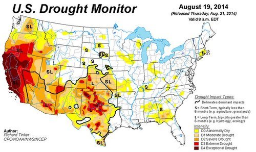
Wildfires continue to be the story out west as large areas of not only western Canada, but also the western United States are experiencing tinder dry conditions. As explained in last week’s EIWN, these conditions are due to the persistent ridging that took place in most of July and early August over the region. The ridge brought limited precipitation and warm, dry air to the western half of North America. The Drought Index reveals this well, showing a large chunk of the western US under severe to exceptional drought.
The Drought Index for this week continues to show significant drought in the west. (Source: USDM)
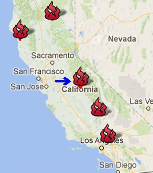
California which has seen no reprieve from the drought and saw another large wildfire flare up this week near Yosemite National Park. The fire, which started on August 18 just to the north of Oakhurst, quickly grew into a large wildfire that was out of control. Numerous air tankers, as well as 1,300 firefighters on the ground, are actively fighting the blaze. Yesterday the crews were able to gain more control of the fire, which was 95% contained as of Friday night. The wildfire is expected to be under full control by the end of this weekend. Some 500 structures in the path of the wildfire were at risk of getting torched on Tuesday and about 1,000 people had to evacuate from Oakhurst. As of Friday most homes had been saved though, with only 47 structures destroyed by the fire. The wildfire burnt an area totaling 612 acres, a small fire compared to the China Nose Fire discussed in last week’s EIWN which reached 9,100 acres in size this past week.
Map of current wildfires that are burning throughout California, Yosemite fire identified by the arrow. (Source: CAL Fire)
The next chance for rain in drought-stricken parts of California looks to be Tuesday as a trough digs into California and brings with it a chance of showers, however, there is signficant uncertainty regarding the strength of the trough.
A major low pressure system developing in the United States and forecast to lift northwards into the Eastern Prairies through the weekend will bring generally unsettled weather ahead of a more cohesive area of precipitation that will move through on Saturday night.
Friday
22°C / 15°C
Mostly cloudy with a chance of scattered showers
Saturday
19°C / 15°C
Mostly cloudy
Sunday
23°C / 15°C
Rain ending in the morning; sunny breaks with a risk of strong-to-severe thunderstorms thereafter
Perhaps the single most important thing to keep in mind with today’s forecast is the fact that weather models have little consensus on what’s going to happen over the next few days other than the fact that there will be a large low pressure system that will impact an area somewhere between the Rocky Mountains and the Great Lakes.
That being said, it looks like the next several days will bring mixed weather to Winnipeg. Today will see a chance for scattered shower activity as a weak shortwave rolls across the Red River Valley, but nothing nearly as bad as what hit the city last night, where up to 80mm of rain fell in a rapid deluge through portions of the city that resulted in wide-spread flooding through the hardest hit areas.
Temperatures will climb to around 21 or 22°C this afternoon with a light wind out of the north. Tonight will be mainly cloudy with fairly light winds and a low near 15°C.
Saturday: The Low Approaches
Tomorrow will see mainly cloudy skies with a high of just 19 or 20°C. Winds will pick up out of the northeast to 30-40km/h as the main low pressure system for the weekend strengthens and lifts northwards through the Dakotas. By supper time, rain with the chance for embedded thunderstorms will spread through North Dakota into Southern Manitoba, reaching Winnipeg later in the evening.
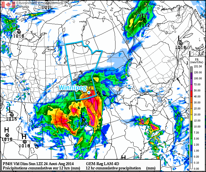
The RDPS is forecasting an intense convective complex with substantial rainfall amounts on Saturday night. Who knows if it’s correct.
The rest of Saturday night will be quite rainy with 10-20mm of rain likely across most of Southern Manitoba with localized amounts in excess of 30-40mm due to embedded convection in the precipitation shield. Some models, such as the RDPS pictured above, want to produce upwards of 50-75mm of rain, although at this point that’s likely overdone and a symptom of what’s known as “convective feedback” in the model, something that ends up causing the model to produce too much precipitation when there is widespread convection occurring. Temperatures will drop to around 15°C again with winds out of the northeast at around 30km/h.
More Unsettled Weather on Sunday
The weather on Sunday will likely improve as the low pressure system lifts through the Red River Valley and pushes off to our northeast. Rain will taper off in the morning and Winnipeg will be left under mostly cloudy skies in what’s known as the “dry slot” — the area behind the cold front located between the frontal precipitation and wrap-around precipitation denoted by descending dry air aloft. The high will climb to around 22°C with some strong northeasterly winds becoming light in the afternoon.
Significant instability associated with the low pressure system will be in place, and even with temperatures climbing only into the low 20’s, it will be enough when coupled with the significant moisture in place to present a risk for strong-to-severe thunderstorms. We’ll have more information in the comments on Sunday.
Things will begin to clear out on Sunday night as the temperature drops to around 13°C.
Into next week looks fairly benign with temperatures gradually returning towards normal by week’s end. There will be a couple cool nights in the coming week with overnight lows dipping into the single-digits.
We’ll be keeping an eye on this system as it develops; slight alterations in the track of the system could dramatically impact forecasts, so if any changes are needed we’ll note them below in the comments. All in all it will be a mediocre weekend followed by an improving week.