A Big Shift in the Weather

A big change in the weather is on the way as a major low pressure system moving across Manitoba through the second half of the week shifts the province into an unsettled and significantly cooler pattern.

Wednesday
30°C / 19°C
Sunny, hot and muggy

Thursday
24°C / 16°C
Morning (thunder)showers then mixed skies with a chance of showers redeveloping

Friday
23°C / 13°C
Mixed skies; slight chance of scattered showers

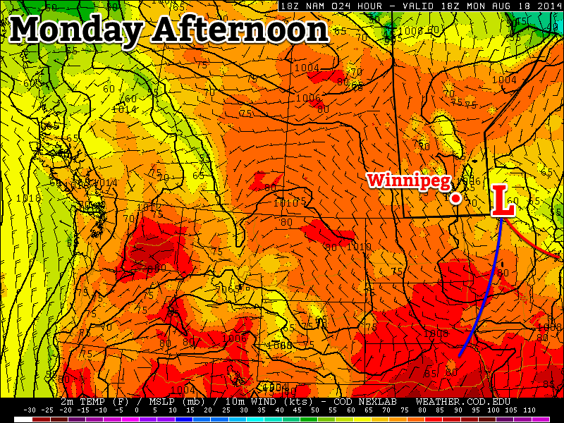
Today will be another gorgeous, warm day with plenty of sunshine and highs in the upper 20’s, perhaps even reaching the 30°C mark. With the developing low pressure system still to our west in Saskatchewan, a broad southerly flow will continue to draw heat northward and trap moisture near the surface. The result will be a fairly humid day that ends up feeling closer to the mid-to-high 30’s instead of “just” the high 20’s. It will also be one of the breezier days in a while with winds picking up to around 30km/h this afternoon. Some cloud cover will likely begin working its way into the Red River Valley through the afternoon or early evening as the incoming low pressure system tracks eastwards.

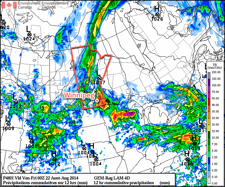
Some showers or thunderstorms will develop through southeastern Saskatchewan and North Dakota and lift northeastwards through the night. Whether or not they move into the Red River Valley is another question altogether. The entire system is moving a little slow and there is uncertainty as to whether the showers will be extensive or tied closely to the surface low. That said, I think that there’s a chance for showers or thunderstorms in Winnipeg through the second half of the overnight period.

Thursday: Likely Wet

Tomorrow will likely start off with some rainy weather in Winnipeg as some rain or thunderstorms move through the city. The potential for a fair amount of rain exists, with models forecasting anywhere from almost nothing to nearly 50mm of rain. While nothing is entirely possible – models can handle precipitation that develops during the night-time in summer poorly – so is the other extreme; with precipitable water values forecast to reach nearly 2 inches (50mm), that same amount of rain is possible if the convective system happens to be a slow-moving one. What happens will depend highly on what develops tonight, so we’ll be keeping a close eye on it.

RDPS forecast precipitation amounts for the daytime on Thursday indicate upwards of 40mm in Winnipeg

The rain will push off to the northeast through the morning and leave us with mixed skies and a chance of some shower activity redeveloping in the afternoon. Winds will be fairly light as the temperature climbs to around 24°C.

Thursday night will be fairly cloudy with a chance of the odd shower as the temperature drops to around 16°C.

Friday: Continued Cooling

Friday will offer a brief reprieve from the unsettled weather with mixed skies gradually becoming more cloudy as the day wears on and a high near 23°C with a northeasterly wind. There will be a slight chance of some scattered afternoon showers, but their impact looks to be minimal if they develop.

Friday night will see temperatures dropping to around 13°C with a decent chance at seeing more shower or thunderstorm activity developing over the Red River Valley as another impulse begins lifting northwards out of North Dakota into Manitoba.

Big Cool-Down in Store for Southern Manitoba

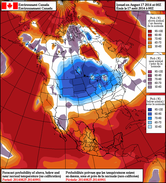
We’re in store for much cooler weather over beginning this weekend persisting through next week as a large upper-level cold trough develops over the Prairies as another system pushes through Manitoba bringing a renewed chance for rain.

The 6-10 day temperature outlook issued by the CPC in the United States shows a high probability of below-normal temperatures.
The 6–10 day temperature outlook issued by the CPC in the United States shows a high probability of below-normal temperatures.

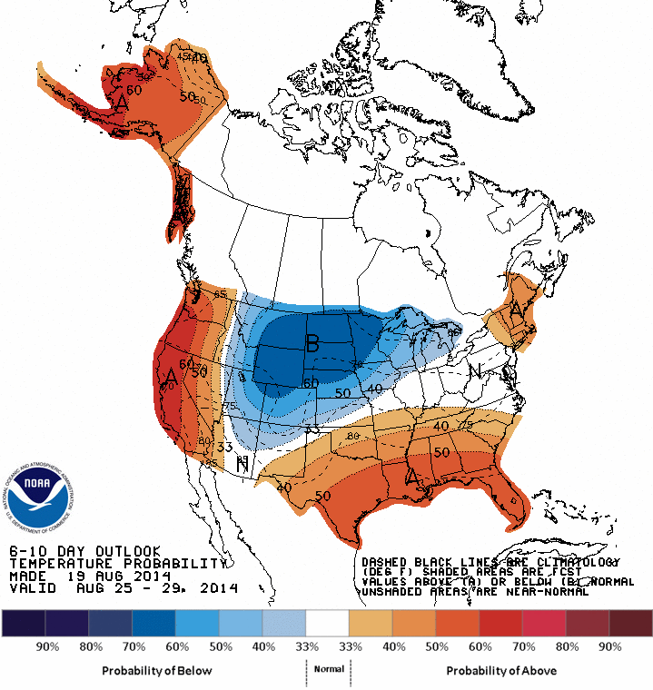
This upper-level cold trough will shunt the jet stream further south and allow much cooler air to spill southwards out of the Arctic. This will drop our daytime highs into the teens and provide some distinctly fall-like weather. There’s some uncertainty to how cold it will get, but it seems fairly safe to say that daytime highs in the mid-teens are likely. Overnight lows won’t be too horrendous, generally dropping into the 5–8°C range.

A Few More Hot Days Before We Cool Down

A few more days of hot weather are in store before we cool down later this week. Enjoy the heat while it lasts!

A low pressure system will bring unsettled conditions to south-eastern Manitoba on Monday

Monday

Monday
24°C / 12°C
Mix of sun and cloud with a chance of showers

Today will be a bit unsettled as a large upper-level weather system traverses our region. There will be a chance of showers and risk of thunderstorms in the Red River Valley and south-eastern Manitoba. Any storms that develop will be non-severe, though there is a slight risk of cold core funnel clouds due to the large amount of “spin” with this system. Temperatures will range from the low to mid twenties across southern Manitoba, with the highest readings in western areas.

Tuesday

Tuesday
28°C / 16°C
Mainly Sunny

Tuesday looks to be a very nice day, with temperatures climbing back up into the upper twenties. Skies will be mainly sunny and winds will be light. No precipitation is expected, except for perhaps a stray shower or thunderstorm.

Wednesday

Wednesday
30°C / 18°C
Mainly Sunny

Wednesday looks like another nice day, with temperatures near the 30C mark. There will be a risk of thunderstorms in western Manitoba, but at this point it looks like they should be non-severe. It appears the main risk with any storms that develop will be heavy rain since they’ll be slow-moving due to a weak jet stream overhead.

Long Range

The long range NAEFS model suggests cooler weather will stick around through the end of the month

Unfortunately, it looks like that cool-down I’ve been hinting at is set to take shape later this week. A cold front will probably pass through southern Manitoba on Thursday, dropping temperatures back into the low to mid twenties for late week into the weekend. Models suggest that we’ll see cooler weather – predominately in the low twenties – stick around into next week.

Elsewhere in Weather News: August 16th, 2014

BC Wildfire Threatens Homes

Numerous large wildfires have been burning throughout western Canada this month due to warm, dry weather in the west. Northern British Columbia and the Northwest Territories have been under the gun for most of July and August as ridging in the west has been persistent. The ridge resulted in warm and dry conditions with weak thunderstorms during the day that have been sparking the fires – not a good combination for fire prevention. As a result, a large portion of central and northern BC is now rated for extreme fire danger. A few significant fires are currently burning in northern BC including the Chelaslie Arm Wildfire and China Nose Wildfire.

BC fire danger rating as of Friday. (Source: BC Wildfire Management)

The China Nose Wildfire which is burning about 300km to the west northwest of Prince George is, as of this writing, zero percent contained and is threatening some 700 homes near China Lake and Houston, BC. As of Friday, estimates size the fire to be around 4,000 hectares – this is up from 1,200 hectares on Wednesday. A second large fire, the Chelaslie Arm Wildfire, is burning west-southwest of Prince George and is much larger than the China Nose Wildfire with an estimated size of 104,000 hectares. Entiako Provincial Park is most at risk from this fire – the park has closed and is under evacuation alert.

Chelaslie Arm Wildfire, seen from air. (Source: BC Wildfire Management)

Conditions are not superb for firefighting either fire this weekend either; westerly winds kicking in later this weekend will result in warm and dry conditions persisting. These fires can also result in poor air quality, not only for cities in the region but also cities downwind of the fires. Plumes of smoke from the fires in BC and the Northwest Territories can be seen traveling thousands of kilometres – as far as southern Ontario – when a northwest flow is in place.

Unsettled Friday Leads Into Beautiful Weekend

Winnipeg will see a chance for some thunderstorm activity this afternoon with the passage of a weak cold front late today, but today’s unsettled weather will lead into a beautiful August weekend.

Friday
30°C / 17°C
Afternoon cloud; late-day thunderstorm likely

Saturday
27°C / 12°C
Partly cloudy

Sunday
28°C / 18°C
Partly cloudy; risk of showers or thunderstorms late in the day

Thunderstorms Possible in Muggy Airmass

Today will be a hot and muggy day. Temperatures will climb to the 30°C mark by the afternoon with dewpoint values topping out around 20°C, making it feel like the upper 30’s. Winds will be light out of the south.

Things will change as a cold front slumping southwards through the Interlake pushes into the Red River Valley late in the day. Scattered thunderstorms are likely along the front late in the day into the evening; in general the storms will be non-severe, however an isolated severe storm with strong winds or large hail may be possible.

A pleasant night will follow the passage of the cold front; the temperature will drop to around 14°C with clear skies.

Beautiful Weekend Ahead

Saturday and Sunday will be beautiful days for late August with dry weather and warm temperatures in store. Things might take a turn towards the unsettled late in the day on Sunday, although there’s some disagreement on the timing of when the next significant system impacts Winnipeg.

Saturday will be partly cloudy with light northeasterly winds as a ridge of high pressure moves across southern Manitoba. Temperatures will top out around 27°C and drop into the low teens – around 12°C – on Saturday night. Humidity levels will be more comfortable as drier air moves into the province behind Friday’s cold front.

Sunday will be another partly cloudy day with a high near 28°C. More cloud will likely work its way into Winnipeg later in the day ahead of the next low pressure system trundling our way.

There’s fair disagreement on the timing of this next system; the US models bring it through the Red River Valley on Sunday evening, while Canadian models move the system slower and don’t bring it into our region until Monday afternoon. Either way, there’s fairly good agreement that this system will bring a broad area of showers and thunderstorms with it. Depending on the timing and evolution of the system, we may end up with the potential for some severe thunderstorm activity.

Sunday’s weather will be something we’ll keep monitoring and provide an update later in the weekend looking at how this upcoming system is evolving.