Although nothing as notable as this past weekend’s rain event is in store, unsettled weather returns for the second half of the week.
Another sizeable low pressure system is making it’s wet presence felt, but this time the hardest hit area will be Southern Alberta where some portions in the foothills may receive as much as 200mm of rain this week. This system will slowly lumber eastwards through the next few days, slowly weakening as it does so but still producing thunderstorms and showers as it goes.
Wednesday: Severe Thunderstorm Risk for Extreme SW Manitoba
Winnipeg will see fairly pleasant weather today with mixed skies, likely leaning towards more cloud than sun, and a high near 25°C with a fairly stiff easterly wind at 30-40km/h thanks to a surface trough building southeastwards through North Dakota.
The main upper low, the heart of this large disturbance, will gradually edge eastwards through the day and will trigger thunderstorms, with some severe storms possible, through portions of southern Saskatchewan and southwestern Manitoba. Shower activity will start off the day in much of Southern Saskatchewan, but the southeast portion of the province will likely see things destabilize enough through the day that thunderstorms are likely by mid-to-late afternoon. The storm activity is most likely to initiate through western North Dakota and then build north/northwestward along the surface trough into SE Saskatchewan and into extreme SW Manitoba through the early evening.
There is an organized threat of severe weather with these storms; we’ve gone with a slight risk due to almost every severe weather parameter looking fairly good except lacking in some subtle way. The main threats will be strong winds and large hail, especially out of any storms that develop early and are sustained as discrete supercells. If the storms develop into a cohesive line, the severe threat will be diminished, although non-zero. There will be a very slight chance for tornadoes thanks to excellent low-level shear, low cloud bases, and a vorticity rich environment being advected eastwards by the upper-level low.

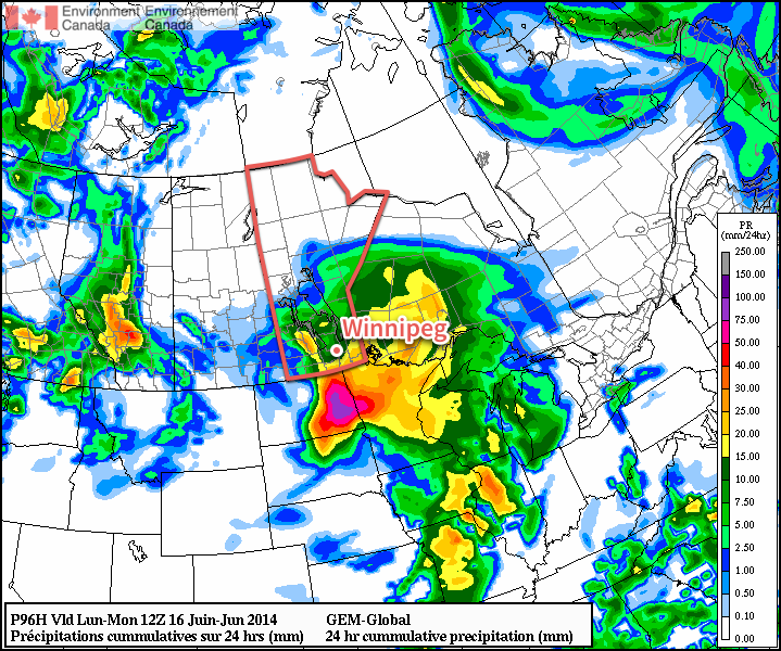
The severe storm threat will push eastwards into the Virden & Melita regions of Manitoba in the early evening with the main threats being strong winds and large hail. It does look like the tornado threat should be restricted to the Saskatchewan side of the border. Southwest Manitoba is in for quite a soaking overnight as the storms expand into an area of convectively driven rain; around 15-20mm is likely for most areas south of the Trans-Canada Highway and west of the Red River Valley (RRV), with as much as 40-50mm possible in areas that see thunderstorm activity as well.
As the area of showers pushes eastwards, it will gradually weaken into an area of showers with possible embedded thundershowers. It looks to reach Winnipeg by Thursday morning.
Thursday: Back to Wet Weather
Thursday will be a cloudy day with a high near 23°C. Shower activity will be in the region in the morning and lift off to the northwest, however while that happens a new batch of rain will be develop to our south and lift northwards through the RRV. Around 10mm seems most likely through the day across most of the region, although if heavier shower activity ends up developing we may see closer to 15mm here in Winnipeg.
The shower activity will taper off on Thursday evening as it all lifts northwestwards into the Interlake and Parkland regions of the province. Winnipeg will see some clear breaks and a low near 14°C.
Friday: Cold Low Showers
Friday will see us underneath the upper-level low which essentially means that there will be a bunch of cold air high up in the atmosphere. With mixed skies, we’ll see temperatures increase towards our high of 23°C fairly quickly through the morning. By mid-day, we’ll likely have hit our high temperature and the atmosphere will become quite unstable. Expect widespread shower and thundershower activity through the Red River Vally. Rainfall amounts will be highly variable and dependant on how many showers any one spot sees and how fast things move along.
Overnight, the shower activity will consolidate to right around the upper low on Friday night as it drifts through our region and into Minnesota. The temperature in Winnipeg will drop to around 14°C.