Saskatchewan/Manitoba Border Chase – May 29th, 2014
Three quarters of the A Weather Moment team (plus a U of Manitoba student) went storm chasing on Thursday. This is a summary of what happened, written by Scott.
We left Winnipeg around 11am and drove straight to Brandon, arriving by 1:30pm. Once in Brandon we made our obligatory stop at Subway and reassessed the situation. We figured from Brandon we’d have to go west for sure, but the question was whether to go straight west, north-west, or south-west. We opted to not commit, and just drive another 45min west to Virden to reassess there again.
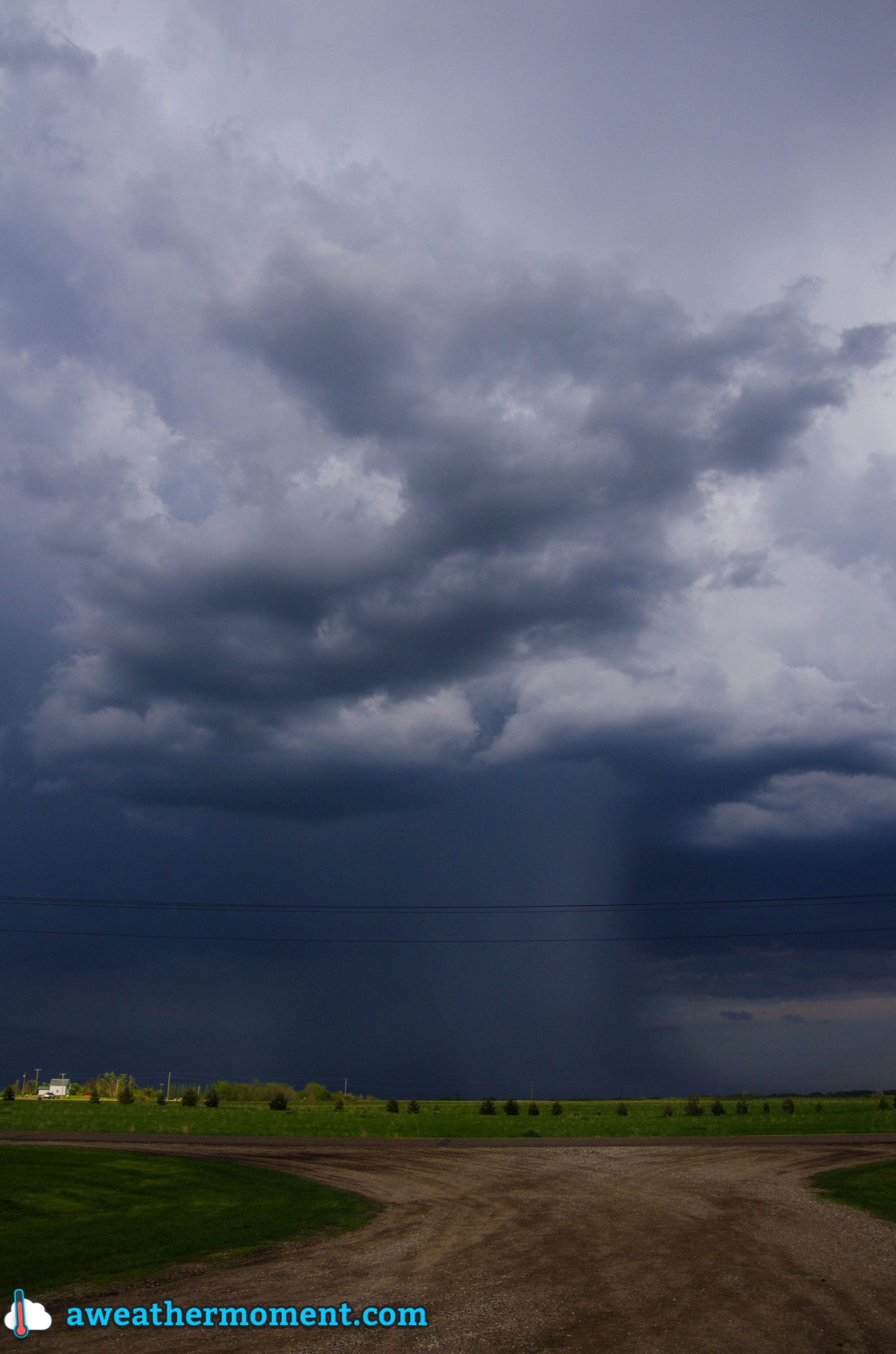
While in Virden we noticed a decent looking cell coming out of Saskatchewan, but it was expected to move well north into the Riding Mountains. We drove toward it a bit in case it decided to right move, but of course it did not (it was heading into the forest), so we then backtracked to Virden. On our way back we saw some good activity developing near Melita, so we went to investigate that. Upon arrival in Pipestone (just north of Melita), we got a clear view of that Melita storm, but it was featureless and high based…yuck. It then appeared that there were some supercellish structures coming out of Saskatchewan, so we figured we’d check them out. The surface winds in their vicinity had already switched to westerly, but we figured if they moved into Manitoba quickly enough they might have a chance. However, we quickly found out they were already too far behind the front for that to happen. So that was that, no supercells for us! We then turned around and started heading for home.
High based storm near Pipestone; featureless with a rain/hail shaft. (Taken by Matt)
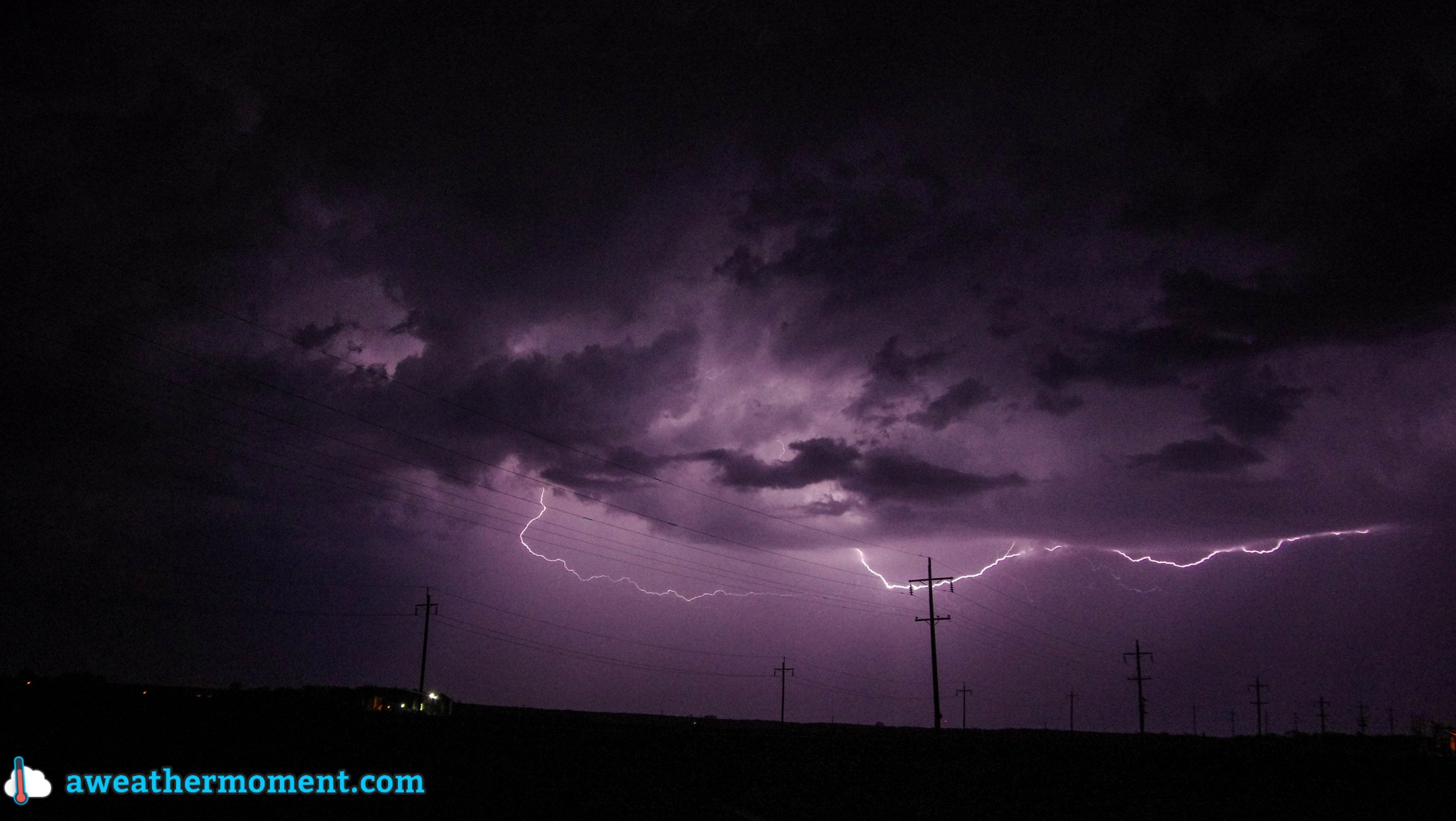
As we drove back, a couple of core punches were performed around Brandon to get through a line of storms. Upon reaching the other side of the line near Carberry it was getting dark, so we decided to stop for lightning pictures – good idea. The lightning was beginning to pick up and some CG strikes were noted. It then began to rain and we moved east again to Portage and stopped for more pictures – very good idea! In Portage there were powerful CG strikes every 5-20 seconds (roughly), which made for many really great pictures. We took pictures there for a while, but then it started to rain again, so we moved east again, this time to Oakville.
Fork lightning south of Portage. (Taken by Matt)Overall, it was a disappointing day for daytime storms, but the nighttime lightning made up for a lot of that. Even though the storms weren’t that great, it was still a fun day just chatting and joking about our misfortune. It’s only May after all, so we’re still in a bonus month for storms as far as I’m concerned.
After what ended up being a fairly busy thunderstorm week considering it’s not even June yet, the weather is expected to settle down for the next while with pleasantly mild temperatures and little in the way of precipitation.
Friday
25°C / 15°C
Cloudy with sunny breaks. Chance of showers or thunderstorms this morning. Chance of showers overnight.
Saturday
24°C / 13°C
Mainly cloudy; clearing later in the day.
Sunday
22°C / 13°C
A few clouds.
Friday
Today will be quite a pleasant day overall. Any remaining showers along the cold front will move through by midday, then leaving us with mostly cloudy skies, although we’ll likely see a few sunny breaks. Temperatures will be mild with a high near 25°C and winds will be fairly light out of the northwest.
Skies will be cloudy tonight as a disturbance tracking through North Dakota spreads some cloud and showers northwards. Here in Winnipeg, there’s only a very marginal chance that we might see some light shower activity. The risk will increase in the Red River Valley towards the US border, with the greatest risk being in the SE Red River Valley. Even so, amounts are only looking to be in the 2-4mm range.
Expected precipitation from the NAM on Saturday night.
For any weekend campers, the Sprague region looks likely to see some rain tonight with accumulations of around 5-10mm. Further north in the Whiteshell there’s only a chance of showers similar to that in the Red River Valley.
The overnight low in Winnipeg will be near 15°C.
The Weekend
The weekend is shaping up to look very nice. Saturday will bring mixed-to-cloudy skies clearing sometime late in the day or in the evening. There may be a slight chance of a few light, lingering showers through the morning.
The high will be around 23 or 24°C and the overnight low will drop to near 13°C.
Sunday will bring mainly sunny skies with some scattered afternoon clouds and a high in the low 20’s. Sunday night will feature clear skies and a low near 13°C.
Southwestern Manitoba will be under the gun again for the potential of strong to severe thunderstorms.
In what has suddenly become a somewhat busy start to the season, more thunderstorms are expected through the remainder of the week, with a threat for severe thunderstorms tomorrow in the southwest corner of the province.
Today & Tomorrow
Wednesday
25°C / 13°C
Cloudy periods
Thursday
28°C
Chance of morning showers or thundershowers. Risk of a thunderstorm late in the day.
Thursday Night
15°C
Showers or thunderstorms likely.
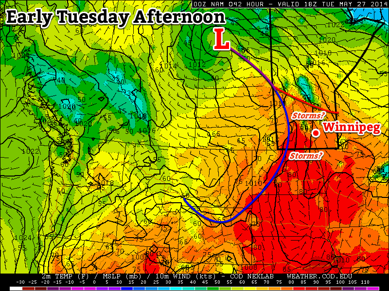
In Winnipeg today we’ll see some cloudy periods but overall a very nice day with light winds and a high near 25°C. The main focus for weather will begin in Southern Saskatchewan where conditions are very favourable for severe thunderstorms. Storms will likely initiate mid-afternoon in south-central Saskatchewan and begin tracking eastwards.
The storms will quickly grow into supercells thanks to ample available energy and strong veering wind profiles. The storms across Southern Saskatchewan will carry with them the risk of all severe modes of weather: damaging winds, flash flooding due to torrential downpours, large hail and tornadoes. It will be a potentially dangerous afternoon in south-central Saskatchewan.
The RDPS 3hr. precipitation panel depicts the strong thunderstorms in south-central Saskatchewan this afternoon.
The storms will continue northeastwards through the overnight period, sustained by a strong low-level jet. The storms will enter Manitoba later in the overnight period, with the main focus through the Parkland region, but with the potential for storms extending southwards into SW Manitoba to the US border. At this point, it doesn’t appear that the storms would carry a significant severe threat, but there does seem to be a slight chance that they would be able to produce marginally severe hail if they do develop.
We’ll see the remainders of that convection move through the Red River Valley Thursday morning. It may still be thunderstorms at that time, it may just be some scattered showers and cloud; it will depend highly on exactly what develops in the overnight period.
Moving into Thursday afternoon, the thunderstorm risk returns to Southern Manitoba with a slight risk of severe thunderstorms in southwest Manitoba and possibly creeping into the southwestern Red River Valley. A low pressure system lifting northeastwards through the province will drag a cold front slowly eastwards through the afternoon. While a few unknowns still hinder the forecast – primarily what effect morning convection may have on the environment and how much cloud will linger, preventing things from warming up too much – the setup looks favourable for the development of strong to severe thunderstorms.
Updated issue of our thunderstorm outlook for Thursday afternoon through to Friday morning. View initial outlook.
A favourable storm environment will be in place by the afternoon hours in southwest Manitoba, with CAPE values exceeding 1500J/kg, decent convergence along the cold front, very unstable mid-levels and a fairly favourable vertical wind profile. It seems quite plausible that supercell thunderstorms could develop along the cold front in the mid-to-late afternoon and then slowly track eastwards. Should severe storms develop, all modes of severe weather would be possible, including localized flash flooding, large hail, and strong winds. Tornadoes cannot be ruled out, however the low-level wind structure may not be quite conducive enough to generate the required environment.
The forecast sounding from Brandon clearly depicts the capping inversion in place on Thursday afternoon.
Some uncertainty plagues the forecast, however, and it’s mainly focused on the “cap” in place. A “cap”, or capping inversion, is a layer of warm air usually somewhere in the first 2-5km of the atmosphere that inhibits air being lifted from the surface from continuing to higher altitudes. This feature can be overcome with enough forcing, which then allows the air parcel to rise since it’s warmer than the air around it – depicted with red shading in the image.
If the cap stays strong, there will be little hope for storms until late evening into the overnight period, and those storms would only be marginally severe.
It seems likely, though, that the cold front will erode the cap and provide enough forcing to generate thunderstorms, so our current outlook calls for a slight risk of severe thunderstorms over southwestern Manitoba into the Red River Valley. There is a chance that we may push the slight risk area further north and northwest, including more regions along the Trans-Canada Highway as well as some areas in Parkland Manitoba, but we’ll wait for further evidence that supports that move before we jump on that.
The storms will slowly track eastwards and showers and thunderstorms are likely over much of the Red River Valley overnight Thursday into Friday morning.
Friday & Beyond
23°C / 15°C
Showers likely, then clearing in the afternoon.
Friday will bring the remnants of any precipitation along the cold front through the Red River Valley in the first half of the day, then we’ll see clearing skies as this system pushes off to the east. The high will be near 23°C and the temperature dip into the mid-teens on Friday night.
The weekend is looking drier for the most part. A system tracking through North Dakota may spread some rain into the southern Red River Valley, but at this point its looking like things should remain south of the border. Sunday looks like quite a pleasant day with sunny skies and temperatures in the mid-20’s.
AWM Chase Day
Much of the AWM team will be out chasing storms in SW Manitoba today. You can follow along with them through their tweets here:
Tweets from https://twitter.com/aweathermoment/lists/the-awm-team
!function(d,s,id){var js,fjs=d.getElementsByTagName(s)[0],p=/^http:/.test(d.location)?’http’:’https’;if(!d.getElementById(id)){js=d.createElement(s);js.id=id;js.src=p+”://platform.twitter.com/widgets.js”;fjs.parentNode.insertBefore(js,fjs);}}(document,”script”,”twitter-wjs”);
Seasonal to above seasonal weather will continue this week, a nice change from the miserable first part of May.
There will likely be a chance of thunderstorms in southern Manitoba on Tuesday
Monday
Monday
24°C / 13°C
Mix of sun and cloud
Today will feature much calmer weather than what was experienced on the weekend. High temperatures will be in the low to mid twenties in southern Manitoba under a mix of sun and cloud. The wind will generally be light and from the north or east.
Tuesday
Tuesday
27°C / 15°C
Mix of sun and cloud with risk of a thunderstorm
The threat for thunderstorms will resume in southern Manitoba on Tuesday. At this point there is still a lot of uncertainty as to how the thunderstorm risk will evolve. At the high end, there could be numerous severe storms, and even a slight tornado risk. At the low end, storms would likely just produce small hail and gusty winds. It’s too early to say what the storm mode will be on Tuesday, but bear in mind that severe storms are a possibility. The chance of thunderstorms on Tuesday will make the temperature forecast a bit uncertain as well. If there are no storms, and therefore no additional cloud cover, then we’re looking at temperatures in the upper twenties. However, if there is additional cloud from thunderstorm activity, then highs will probably be in the mid twenties. More details on Tuesday’s potential for storms will no doubt be found in the comments below over the next couple days.
Wednesday
Wednesday
25°C / 16°C
Mix of sun and cloud with risk of a thunderstorm
Wednesday is another tricky forecast, as rain may or may not affect the forecast again. Some weather models bring an area of rain and thunderstorms through southern Manitoba in the morning, which would greatly impact the temperature forecast. Like Tuesday, it’s too early to say if this will happen, but it’s certainly a possibility. High temperatures in the mid twenties look most probable, but that outlook could change depending on what happens with the chance of rain.
Long Range
The long range forecast continues to look stormy through the end of the week. Most weather models suggest that there will be a risk of severe thunderstorms in southern Manitoba on Thursday and/or Friday. I feel like I’m saying this a lot, but there is still a lot of uncertainty in this part of the forecast. Models are still not correctly resolving the speed of this system, and until that happens it will be tough to say much about the thunderstorm potential with any certainty. Beyond this week, the weather will likely stay near, to slightly above seasonal values, a nice way to transition into June!


