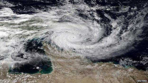
Storm Brewing?

Our weather may be about to take a turn towards more active conditions, as a major winter storm looms this week.

A Powerful Low Pressure System is Forecast to Impact Southern Manitoba on Tuesday

Monday

Monday

Cloudy. Snow.
-4°C / -8°C

The weather will begin to take a sour turn on Monday, with some initial bands of snow moving through Southern Manitoba. Areas along the International Border could see 5-10cm of snow through the day on Monday, with areas further north receiving 2-5cm. Temperatures will remain in the single digits with gusty north-east winds.

Tuesday

Tuesday

Snow. Blizzard Possible.
-8°C / -15°C

Tuesday is when things could really get ugly. As of Sunday evening, models were suggesting that this winter storm may move into north-western Minnesota on Tuesday evening, with it’s pressure dropping below 1000mb. At the same time, an arctic high is forecast to slide down into Alberta, generating a large pressure difference across the prairies. This pressure difference will generate very strong winds by late Tuesday. If this storm also produces snow in Southern Manitoba on Tuesday as we currently expect, then the combination of that snow and very strong winds will generate blizzard conditions. Total snowfall on Tuesday into Tuesday night could be 10-20cm in Southern Manitoba along with wind speeds of 40-50km/h gusting to 60-70km/h. Travel may become very difficult to impossible by Tuesday night.

Wednesday

Wednesday

Blizzard Ending
-15°C / -20°C

Snow may continue into Wednesday morning, along with the strong winds. If this storm tracks as currently expected we could see blizzard conditions persisting through a good part of Wednesday in Southern Manitoba. The wind should taper off somewhat on Wednesday night, but it will remain breezy on Thursday.

Long Range

The long range forecast is pretty simple – it will be COLD! After this week’s weather system departs on Wednesday we will see arctic air take over, and it will be the coldest airmass so far this season.

Elsewhere in Weather News: November 30th, 2013

Cyclone Lehar Hits India

This past week a weak cyclone hit India’s east coast as a weak cyclone depression. The cyclone – Cyclone Lehar was classified as a severe cyclone in the Bay of Bengal with winds over 100km/h but has since been downgraded. Unfavorable sea surface temperatures and shear for storm development did a good job on tearing up the storm apart before landfall. The storm made landfall as a tropical depression on Thursday, with winds of 60-70km/h at landfall. Evacuation precautions were taken by the India Meteorological Department because of the strength of the cyclone while it was over the Bay of Bengal but the only real threat that Lehar brought was flood threat. No significant damage was reported from the storm but some crops have been damaged and a few districts vulnerable to flooding in India’s Andhra Pradesh state have been affected by flooding.


Cyclone Lehar as it was struggling to organize over the Bay of Bengal. (Source: NDTV)

Arctic air dominated over a good part of both Europe and the United States this week which brought minimal significant weather to the regions. Apart from significant snowfall associated with a trough of low pressure affecting the eastern seaboard of the United States earlier this week, active weather has been kept to a minimum. The next big weather event is likely to be a winter storm which will affect the northern states (MT, ND) and even southern Manitoba on Tuesday and Wednesday of next week.

Milder Weather On Tap

A broad trough of low pressure will push eastwards across the Prairies bringing with it milder temperatures and the occasional chance for some more light snow.

Friday

-7°C / -14°C
Mainly cloudy with flurries.
Saturday

-8°C / -12°C
Mixed skies; slight chance of isolated flurries.
Sunday

-8°C / -10°C
Cloudy with a chance of scattered flurries.

We’ll see fairly cloudy skies today alongside an increasingly brisk southerly wind to 30–40km/h as a warm front approaches the Red River Valley from the west. This front will produce an area of 5–10cm of snow through the Interlake and areas west and north, but here in the Red River Valley we’ll see some periods of light snow with no significant accumulations expected. Temperatures will climb to around –7°C as the winds ease up in the afternoon and see gradual clearing through the evening and overnight as the mercury then drops to about –14°C.

Saturday will bring a few remnant clouds in the Red River Valley that will possibly produce some isolated flurries, but it should end up being a mostly sunny day with light winds and a high near –8°C.

Cloud will roll in on Saturday night as a low-pressure system begins working it’s way across North Dakota. The accumulating snow is expected to remain States-side at this point, with just some light snow working it’s way north of the border. Minimal accumulations are expected at this point, although regions close to the U.S. border could possibly see a cm or two of the white stuff if the system tracks just a smidgen further north.

The Start of Next Week

The first half of next week looks to bring some very mild air into Southern Manitoba with temperatures climbing as high as low minus-single-digits on Monday! It will be short-lived, however, as a significant cold trough begins working it’s way into the Prairies and brings below-normal temperatures for the second half of the week.

Snowy Mid-Week Interlude

A trough of low pressure pushing across Southern Manitoba today will spread light snow into the Red River Valley this morning.

24hr. accumulated precipitation from the RDPS for today and tonight. General amounts of 2-3mm, equating to 2-5cm of snow will be expeted through the Red River Valley.
24hr. accumulated precipitation from the RDPS for today and tonight. General amounts of 2–3mm, equating to 2–5cm of snow will be expeted through the Red River Valley.

The overall pattern will flatten out after this system, bringing us out of the warm-cold roller coaster and back into a more stable — albeit slightly below normal — temperature pattern.

Today

Wednesday

-8°C / -14°C
Light snow starting this morning. Flurries this evening & overnight.

We’ll see a cloudy start to the day with snow pushing towards Winnipeg & the Red River Valley from the west and northwest. Light snow should push into the area by mid-morning. The heaviest snow will occur midday before tapering off through the afternoon. We’ll climb to a high temperature around –8°C today, which is still a couple degrees below normal for this time of year. The organized snow will move off by the evening, however lingering scattered flurries will likely persist through the evening and overnight periods. Skies will remain mainly cloudy until either late overnight or early tomorrow morning. All in all, not too much snow is expected, with around 2-3cm likely but with 5cm possible as an outside chance.

Thursday & Friday

Thursday

-10°C / -16°C
Mainly sunny.
Friday

-10°C / -13°C
Mainly sunny.

We’ll move into a quieter, more stable pattern for the remainder of the work week with a slowly weakening northwesterly flow aloft. We’ll see mostly sunny skies both Thursday and Friday with daytime highs near –10°C. We may see some light snow on Friday night as a weak warm front pushes across Southern Manitoba.

The Weekend

A broad area of low pressure will be in place across the Prairies this weekend bringing some cloud and slightly warmer temperatures. Models are showing a slight chance of more snow to start next week with an Alberta clipper racing along the 49th. As always, we’ll be keeping an eye on things!