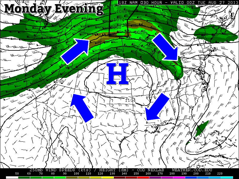
After a couple slightly cooler days across Southern Manitoba the heat is set to return as a southerly flow develops ahead of a upper trough pushing towards the Rocky Mountains. Unlike the potent upper ridge of earlier this week, this southerly flow will be peppered with disturbances ejecting northeastwards out of the west coast trough and we’ll see substantially more unsettled weather over the next week or so.
Today
Friday 30°C
30°C /
20°CSunny & increasingly windy. Chance of thunderstorms & increasing humidty overnight.
We’ll today start off pleasantly as we head towards a high of about 30°C, however by midday the winds will begin pickup up out of the south and will likely reach 40–50km/h with gusts as high as 70km/h by the end of the day, making it not quite as pleasant as 30°C can be. We’ll see a mix of sun and cloud as well as some mid-level cloud streams up from the southwest through the day. Fortunately it looks like the worst of the humidity will stay off to our south for the day and, with dewpoints only in the low teens, will help the day be a little more comfortable.
There will be a chance of thunderstorms overnight into the morning hours on Saturday though as the first of many impulses lifts northeastwards into Southern Manitoba, dragging up with it substantial amounts of humidity. Overnight we should see our dew point climb to nearly 20°C, which means we’ll only see our overnight low dip to close to that mark. Regarding the thunderstorms, at this point it looks like the greatest threat for any activity will be over SW Manitoba then arcing NE through the Interlake region. There will be a chance of a thunderstorm through much of the Red River Valley, with the greatest risk at the north end – Winnipeg in particular could end up seeing the bulk of the action if things end up just a bit further south than currently forecast – and a decreasing risk towards the U.S. border. These storms are not expected to be severe, however given the ample moisture that they will be feeding off of, any storms that develop could produce substantial amounts of rainfall in short periods of time.
Saturday
Saturday 32°C
32°C /
18°CA mix of sun and cloud; risk of thunderstorms in the morning and then the afternoon.
Saturday will start off cloudy, potentially with showers or thunderstorms in the region, and then begin gradually clearing. It will be very humid in the Red River Valley, with dew points in the low 20’s. We’ll climb towards a high of around 32°C which, with the humidty, will feel much more like 37–40°C. In the afternoon a sharp dryline will begin working it’s way eastwards into the RRV associated with drier, westerly winds.
Thunderstorms are possible by late afternoon, but the exact location of them will depend on the entire synoptic setup and the placement of the dryline, which will be the feature that the storms will develop along. At this point, it appears that the western half of the RRV will be safe with an increasing risk through Winnipeg & the central RRV to a much greater chance over the eastern RRV into Sprague & the Whiteshell. These storms could easily become severe given the ample heating and surface moisture, 500mb jet core in the area providing 30–40kt of bulk shear, as well as a defined trigger in the dryline.
The storm potential does seem fairly dependant on the exact placement and strength of the dryline; if it doesn’t evolve to be strong enough or hangs back too long or blows through too early, then there will be almost no chance of any storms on Saturday. If storms develop, the main threats (particularly if they become severe) will be torrential rain and large hail. A tornado could not be ruled out either, but the flow may not be strong enough to support/sustain one. Strong winds would not be a widespread concern at this point.
And of course, since there has to be one more wrinkle in things, this will all be dependant on mid-level temperatures. The Canadian long-range model (GDPS) is forecasting cooler air at the mid-levels pushing over the RRV on Saturday afternoon, which would help destabilize things; if temperatures remain warmer at the mid-levels then we would likely remained capped and see have no thunderstorm activity. A lot of words for a conditional threat, but it could be a significant severe thunderstorm day for the Red River Valley and the Whiteshell, so I thought we should go over some of the possibilities and unknowns!
Sunday
Sunday 32°C
32°C /
18°CMainly sunny.
Sunday will be a very nice day with mainly sunny skies, light winds, and a high near 32°C. There will be little to no chance of any precipitation; at this point it looks like there may be a marginal chance of an isolated thunderstorm near the U.S. border in the Red River Valley, but even that is pretty unlikely. Humidity will actually be quite comfortable as well, with dew points in the low teens. Probably the nicest day of the weekend, so get out there and enjoy it!
Next Week
Without spending too many words on it, next week continues the warm trend with highs looking to be near 30°C much of the week; we’ll also see multiple disturbances move through bringing showers and thunderstorm threats to Southern Manitoba. It will likely be more pleasant than not, though, and our late-arriving summer will certainly continue!