Above-Normal Temperatures Continue

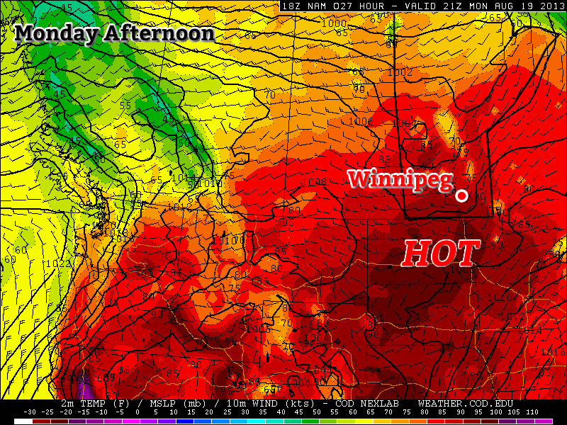
The above-normal temperature streak we’ve seen the past few days will continue through the rest of the week – albiet at a slightly moderated level – until a more unsettled pattern develops for the weekend.

Today & Tomorrow

Wednesday

26°C / 11°C
Mainly sunny.
Thursday

26°C / 13°C
Sunny.

We’ll see mainly sunny skies the next couple days as a ridge of high pressure slides across the province in the wake of the cold front that pushed through last night.

This ridge of high pressure will bring a break from the 30°C+ weather we’ve had the past couple days, bringing us back down to closer-to-seasonal temperatures in the mid–20’s. We should reach about 26°C each day which is still a couple degrees warmer than the seasonal average of 24°C for this time of year. The evenings will be quite cool, generally near 10–12°C although temperatures could potentially dip into the single-digits tonight in some areas.

Friday

Friday

27°C / 17°C
A mix of sun and cloud; slight chance of showers or thunderstorms.

We’ll see a regime change come Friday as a leading impulse approaches the province ahead of a developing long-wave upper trough over the west coast. A southerly flow will redevelop ahead of this impulse pushing moisture northwards out of the Northern Plains back into Southern Manitoba; as such, we’ll see a noticable increase in humidity as temperatures climb to around 26–28°C.

Precipitation is a bit of a wildcard at this point; some models bring a wide area of rain and thundershowers into the Red River Valley in the morning and persisting through much of the day until the impulse moves into NW Ontario while others keep much of the rain north of the RRV in the Interlake and bring thunderstorms in during the evening hours.

I think that most of the precipitation will push north of the city, but I certainly can’t rule it out at this point. We’ll definitely see a mix of sun and clouds, though. It looks like a chance for thunderstorms will persist through much of the evening and into the overnight period as well.

Long-Range Outlook

This weekend we’ll see warm, humid and generally unsettled weekend ahead with showers and thunderstorms likely Saturday & Sunday in Southern Manitoba.

NAEFS 8-14 Day Outlook initialized 2013-08-20 12Z

The NAEFS 8–14 day outlook shows slightly above-normal temperatures persisting in the 1–2 week timeframe.

Looking to next week, we will continue to see above-normal temperatures as a slack or southerly flow persists. We’ll also see dew points in the high teens making it feel relatively humid as well. After a month of below-normal temperatures, it looks as if we get to enjoy a late summer after all!

Heat Continues

The hot weather will continue into this week, with some of the hottest weather of the season on Monday and Tuesday.

Monday Afternoon Temperatures in Southern Manitoba

Monday

Monday

Mainly Sunny
33°C / 15°C

Monday will be a hot, but decreasingly humid day. The morning and early afternoon may be on the humid side, but a westerly wind and mixing of drier air from aloft should remove a fair amount of moisture from the air by late afternoon into the evening. Highs on Monday will be in the low thirties, with nice sunny skies.

Tuesday

Tuesday

Mainly Sunny
33°C / 12°C

Tuesday will again be hot, but not humid. Another plume of hot air coming off the Rockies will allow temperatures to climb into the low and maybe even mid thirties over Southern Manitoba. Just south of the border there may be the potential for upper thirties temperatures in the Fargo and Grand Forks areas. Depending on how far north this plume of warm air pushes, actual temperatures may be slightly warmer or cooler than suggested above. Again, no rain is expected.

Wednesday

Wednesday

Mainly Sunny
24°C / 10°C

A strong cold front will push through on Tuesday night, setting up significantly cooler conditions for Wednesday. No significant weather is expected with this front, owing to a dry airmass ahead of it, although a stray shower or weak thunderstorm cannot be ruled out. Highs on Wednesday will only be in the low to mid twenties. The wind will be gusty and from the north-west.

Long Range

Beyond Wednesday it looks like warmer weather will return once again, with temperatures in the upper twenties, or maybe low thirties, looking possible from late this week into next weekend. Summer appears to be making a long term stay.

Elsewhere in Weather News: August 17th, 2013

Utor Update

Since last’s week update on typhoon Utor, much has happened. Utor first made landfall in the Philippines; it wreaked havoc as a high-end category 2 typhoon bringing sustained winds clocked at 170km/h with gusts exceeding 200km/h – making it the strongest storm this year in the area. Following that, it continued on through the South China Sea and made a second landfall as a strong tropical storm on the south shores of China.

Unfortunately, quite a bit of destruction was associated with this typhoon, especially in the Philippines region. Flash floods washed away homes in the central part of the Philippines and landslides were more of a problem in the northern region; due to a more mountainous terrain. Seven people have been casualties of the storm in the Philippines and 42,000 have been reported homeless because of Utor. In addition to causing grief to the Philippines, Hong Kong and part of China (mostly Guangdong province) had to take their precautions to keep residents safe. Stock markets as well as businesses were closed and 118 flights needed to be cancelled. One cargo ship also had to be abandoned at sea as it flipped because strong winds from Utor. All of the 21 crewmembers were airlifted to safety.

Utor damage

Ship flipped 90 degrees sideways because of strong winds of Utor. (Source: The Nation/AFP)

Disturbances in the Atlantic

Two areas of interest have formed in the Atlantic Ocean, one near the Cape Verde Islands and another off the Yucatan Peninsula. The first one near the Cape Verde Islands, named Erin, is of tropical storm force and is drifting west. It will be interesting to see how it interacts with dry air the next couple of days. There is a possibility it might not survive not only because of the dry air but also because of “cooler” sea surface temperatures near 26°C. The second area, a broad area of thunderstorms, is not of tropical storm force and may never become a tropical storm. There is much uncertainty where this system will make landfall and how strong it will get. Models show anywhere from Louisiana to Brownsville, Texas. Wherever it will make landfall it will be a big rainmaker though, bringing in very moist air from the Gulf of Mexico; PWAT values over two inches.

Erin

IR Satellite image of Erin as of Friday night. Quite a bit of dry air on the south part of the storm. (Source: CIMSS)

Hottest Weather So Far This Year Ahead

The warmest weather we’ve seen all year is shaping to move in today and persist through the next week as a upper ridge begins to build in over the Prairies. The heat and humidity will be here in full force with daytime highs climbing over 30°C and dew points climbing into the upper teens or even perhaps the low 20’s.

Friday

30°C / 15°C
Mainly Sunny
Saturday

33°C / 17°C
Mainly sunny with a slight risk of a late day thunderstorm.
Sunday

30°C / 17°C
Mainly Sunny

We’ll see beautiful sunny skies today as our temperature climbs to around 30°C. The humidity will become more noticable as the day wears on as the dew point climbs from the low teens to around 17 or 18°C. Temperatures will drop to around 15°C tonight under clear skies.

Tomorrow looks to be a scorcher of a day. The temperature will climb into the low 30’s with high humidity as the dew point climbs over 20°C. It will feel closer to 38–40°C by the afternoon as the Red River Valley bakes in the warmest temperatures of the year. A disturbance will be moving through the Interlake region that will bring a very slight risk of a thunderstorm late in the day, although at this point it looks like most of the activity will stay north of the Red River Valley. Beaches along the South Basin of Lake Winnipeg will have a greater chance of seeing thunderstorm activity than we will here in Winnipeg, so if you’re planning on camping north of the city, that may be something to keep in mind. We’ll have updates below in the comments on the thunderstorm potential tomorrow. We’ll head to an overnight low of aroun 17 or 18°C Saturday night.

Sunday also looks to be a gorgeous day. The hottest weather will be off to our east, but we’ll still see temperatures climb to around 30°C under sunny skies. There will be more of a westerly component to the winds which will help flush out some of the humidity through the day.

Next Week

Next week looks to keep the heat. While the upper ridge flattens thanks to a couple disturbances that move through on the weekend, it’s set to rebound by mid-week, which will keep our daytime highs in the upper 20’s or low 30’s for what looks like the entire week. At this point it looks like we may see some showers or thunderstorms on Monday evening/night, but after that current indications are that it will be hot and dry for the remainder of the week.

After 4 weeks of below-normal temperatures, get out there and enjoy the heat wave! Just be sure to practice some heat safety and wear hats and drink plenty of water. Have a great weekend!