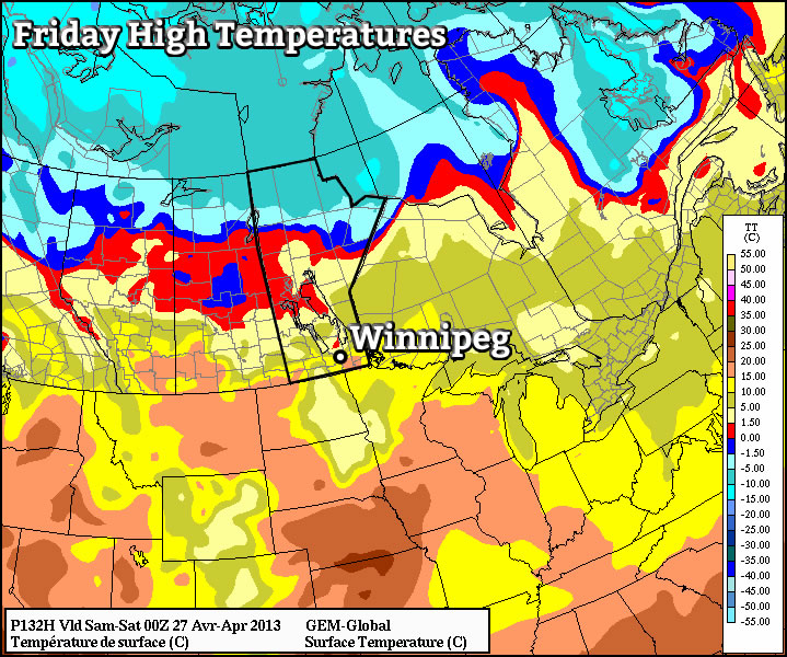
Unsettled Weather Ahead

A warm but unsettled few days are ahead as mild Pacific air surges across Southern Manitoba.

850mb Temperatures valid this evening

850mb temperatures from the NAM valid for early this evening.

Snow will taper off early this morning with a lingering chance of a stray flurry or two sticking around through much of the day across the northern half of the Red River Valley. Southerly winds will pick up through the day to 30-40*km/h as the warm front alluded to in Wednesday’s post pushes into the Valley. Temperatures will warm up quickly as the front passes with temperatures climbing to around -4 or -3°C, a few degrees warmer than the seasonal normal of about -6°C. Temperatures will remain steady through the night as that south wind continues to keep us in the warm air.

Another disturbance will pass through the northern Red River Valley tonight, however there’s some uncertainty to the areas that precipitation will fall. It currently looks like most, or all, of the precipitation will fall north of Winnipeg, focused in the Interlake region. There’s a slight chance that it will fall a bit further south, clipping Winnipeg and other areas in the northern half of the Red River Valley. If any areas in the Red River Valley are affected by this disturbance, they’ll almost certainly have to deal with freezing rain as there will a massive AFL (Above Freezing Level) just off the surface where temperatures will be nearly +10. With precipitation falling through it, the AFL will cool to 2-3°C, which is still more than warm enough to melt any snow that will be falling into it. Potentail freezing rain accumulations will be light but not insignificant at 1-2mm. Just to reiterate, the risk area for freezing rain will likely be confined to the northern half of the Red River Vally.

In addition to the weather from this disturbance, there will be the potential for freezing drizzle through the entire RRV as warm, moist air overruns our cold snowpack.

Saturday and Sunday will be cloudy days with beautifully warm temperatures for this time of the year. Daytime highs will sit right around 0°C. There will be a slight chance of non-accumulating flurries Saturday night into Sunday, otherwise no significant weather is expected. As winds lighten up, there will be the potential for fog patches through the valley in the overnight hours.

A storm system looks to move into the area on Monday morning, bringing rain or snow in the morning and snow in the afternoon. There’s still uncertainty in the track of the system and how much of the precipitation will impact the Red River Valley, so we’ll be sure to provide an update or two in the comments below through the weekend. The one thing that is certain is that this system will mark a return to more seasonal temperatures as cooler air sweeps over Southern Manitoba in it’s wake.

Warmer Weather and a Bit of Snow on The Way

Arctic ridging will keep our temperatures low over the next couple days but rest assured, warmer weather is on the way.

12hr. QPF for Thurday Night

12hr. precipitation amounts for Thursday night. A band of snow will pass through Southern Manitoba with greatest accumulations through the Interlake region and amounts diminishing towards the U.S. border.

We’ll see another cooler than normal day today as a weak low passing through Central/Eastern Manitoba pulls more cold air southwards and allows re-enforcement of the Arctic ridge in place over the Prairies. We’ll see temperatures climb to about -10°C under a mix of sun and clouds today as breezy winds develop out of the south to 30km/h. This will make it feel a lot closer to -20 out there. There may be a slight chance of a very light flurry over Winnipeg and the Eastern Red River Valley this afternoon, however the chances are slim and if it does happen, there won’t be any significant accumulations.

Temperatures will dip towards the -18 to -20°C mark tonight under partly cloudy skies. Tomorrow we’ll see another day with highs near -10°C with a mix of sun and clouds. A warm front will push through on Thursday night, bringing with it some light snow to the Red River Valley. Lightest accumulations will be in the Southern Red River Valley with greater amounts in the Northern Red River Valley into the Interlake; in general, 2-4cm accumulations are likely. Areas south of Morris may, however, end up with little to no snowfall if the area of snow stays just a little tighter to the system centre as it passes through.

For Friday into the weekend we’ll see an unsettled pattern with bouts of light snow possible through much of the time. We’ll be under cloudy skies, but comparatively balmy temperatures will be in place with daytime highs generally around -1 to -3°C.

Cold Start to the Week

This week will start off feeling a lot more like winter, as temperatures drop well below normal.

A high pressure system will bring cold conditions to Southern Manitoba on Monday

A high pressure system will bring cold conditions to Southern Manitoba on Monday

Temperatures this morning will be more like those you’d expect in late January, not late November. This morning’s cold temperatures will moderate somewhat by afternoon, with highs in the mid minus teens expected – not exactly November weather! Luckily some cloud cloud should move in during the afternoon hours, allowing Monday night to be significantly warmer than Monday morning. In fact temperatures may rise a bit on Monday night, up into the -6 to -10C range, in association with a weak low pressure system passing through. This low will bring a few flurries to Southern Manitoba overnight, with accumulations of no more than a centimetre or two expected. Unfortunately, another high pressure system will build in behind this passing low, bringing colder temperatures again for the daytime hours of Tuesday. Temperatures will begin falling back into the minus teens on Tuesday morning as cooler air spills in from the north-west. Tuesday night will be another cold one, with lows back down around the -20C mark. It looks like another small warm-up is on the way for Wednesday as yet another passing low pressure centre allows temperatures to climb back up into the minus single digits.

There remains some uncertainly in terms of how the late week period will play out. Models generally agree that we will stay below-normal for Thursday and Friday, but exactly how cold is not entirely clear. There have also been hints of a more active storm track setting up through Southern Manitoba from next weekend into the following week, something to watch as this week progresses.

Elsewhere in Weather News: November 24th, 2012

Severe Flooding Strikes England

Intense flooding has hit parts of the UK these past couple of days and more is to come this weekend. A strong low pressure system approaching England from the south-west has brought with it plenty of moisture which has already flooded out 300 properties and caused one death.

Flooding

Roads flooded out quickly in South-West England as torrential rains fell this past week, more is to come. (Source: The Guardian)

South-West England is most at risk. Areas including Exeter and Bristol were included in the ‘amber risk’ (second highest level) which was issued by the Met Office as more localised flooding was likely to occur. By Saturday afternoon, it will not be uncommon to see rainfall reports exceeding 50mm in South-West England. This, coupled with ground already saturated to its maximum, will cause flash flood conditions where streams could easily overflow in a matter of hours. In total, 70 flood warnings and 150 flood alerts had already been put in place as of Friday. High winds add to the storm’s grave concern, as gusts of 90km/h are not out of the question for Saturday’s event.

Surface analysis

Surface analysis of the UK on Saturday at 7pm. (Source: Met Office)

Areas of South-West England typically see an average of 16 rainy days and 70mm of rainfall in November. Therefore it’s not unusual to see rain in that area during the month of November but the expected amount to be seen this weekend is on the high end of the spectrum. The highest 24-hour rainfall ever recorded in South-West England (Martinstown) was in 1955 where 279mm, over half of Winnipeg’s annual precipitation, fell!