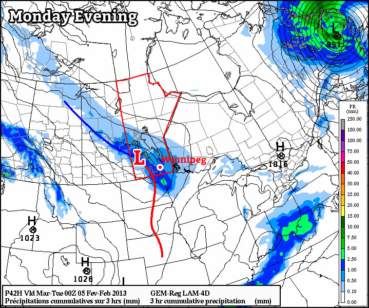
Strong Winds Blast Southern Manitoba

Strong winds will blast across Southern Manitoba today as a very powerful low pressure system crosses Northern Manitoba. The winds will also usher in an unseasonably cool air mass that will give us a very chilly night before the upper ridge begins to rebound into our region.

850mb Temperatures for Thursday morning from the GEM-REG

850mb temperatures for Thursday morning from the GEM-REG. A cold trough of 850mb temperatures between 0-1°C will rest over the Red River Valley and Whiteshell, contributing to unseasonably cold overnight lows.

A powerful low pressure system with a central pressure of approximately 984mb is pushing across Northern Manitoba and will bring a very strong pressure gradient across the Red River Valley today that will usher in 50-60km/h winds with gusts as high as 80km/h. This system has a history of producing very strong winds; on Monday it brought widespread winds in excess of 100km/h to Southern Alberta and yesterday it brought winds between 80-110km/h through Saskatchewan and Northern Manitoba.

The winds will pick up in the Red River Valley this morning and we’ll see several hours of fairly strong westerly winds. Unlike regions to our west that had to deal with the winds for a fairly prolonged period of time, the winds will move through the region fairly quickly as the low accelerates out of Northern Manitoba into Hudson Bay. As a result, winds should let up noticeably by the evening.

In behind this system, fairly cold air will sweep across the province. Across the Red River Valley, overnight lows will be kept a little warmer by some light winds expected to continue through the night. Through the Red River Valley, overnight lows will generally drop to 3-5°C tonight, however if any areas see the wind let up, it would certainly be possible to see overnight lows dip to 1-2°C under clear skies and calm winds. The most likely area for this to happen, though, is a little further east in the Whiteshell where the trees will help protect the surface from light synoptic winds.

Temperatures will return to seasonal on Thursday as an upper ridge begins to build eastwards across the Prairies. We’ll see a mix of sun and cloud across the Red River Valley with a very slight chance of a shower as warmer air begins to push into the region. Daytime highs should be near 19-20°C on Thursday with overnight lows on Thursday night once again rather chilly in the 4-6°C.

Warm air moves back in for the weekend, with plenty of sunshine and highs near 25°C on Friday and Saturday. Things look to cool off a bit on Sunday as another cold front passes through.

The Week Will Start Hot! Then Fizzle…

This week will start out with some nice hot weather, but then rapidly cool off from there. Fall weather appears to be here to stay.

Temperatures are expected to reach the 30C mark in much of Southern Manitoba on Monday

The NAM model is predicting that temperatures will reach the low thirties in much of Southern Manitoba on Monday

Monday will be one of our last hot days of the year as temperatures climb up around the 30C mark in Southern Manitoba. However, the heat won’t last long, as a cold front will sweep through on Tuesday, bringing cooler weather for the rest of the week. Temperatures from Tuesday through Friday are expected to be fairly typical for mid-September, with values in the upper teens or lower twenties expected. No significant precipitation is expected for the first part of this week, though an odd shower is possible.

At this point most long-range models don’t give a clear picture for how September will proceed temperature-wise. For the most part is looks like we’ll see many normal weather, with some ups and downs here and there. A more interesting long-range weather feature to watch is the development of El Nino conditions in the Pacific Ocean. Most long-term forecasts are calling for the development of weak El Nino conditions in the central Pacific Ocean for this fall and winter. El Nino events tend to bring warmer and drier than normal weather to Western Canada. The stronger the El Nino is, the greater the chance we’ll see a warmer and drier than normal winter here in Southern Manitoba. As we move into winter you will no doubt be hearing more about this topic.

Elsewhere in Weather News: September 7th, 2012

Tropical Storm Leslie a Threat to Canada

With the hurricane season nearing its peak in the Atlantic, more tropical systems have spun up this past week. The first system which is not much of a concern (unless you are boating in the middle of the Atlantic) is Michael. Michael, once a category three hurricane, the strongest seen this year, has been spinning in the middle of the North Atlantic for a while now and is not expected to make a landfall.

Leslie

Leslie still not organized very efficiently with a broad circulation on IR satellite as of Friday evening. (Source: Wunderground/NASA)

The second storm; Leslie, however, is spinning west of Michael and has a small chance at making a landfall somewhere on the south-eastern coast of Newfoundland, Canada. Bermuda is already experiencing high surf and there’s a good chance they’ll experience tropical storm force winds this Sunday since Leslie is such a large storm. By that time, Leslie will likely be upgraded to hurricane status of category one. It will slowly start moving north as the trough moving in from Eastern Canada approaches the storm. Though, with that said, Leslie still stands a slim chance at making landfall on Canadian soil and making a significant impact on the province. Since this possibility is still quite a ways away – five to six days – weather models are having trouble deciphering Leslie’s exact future track.

Leslie tracks

Model consensus appears to be leaning towards no landfall and more of a rain event for Newfoundland. (Source: SFWMD)

Even though Leslie might come close to Newfoundland within the next week or so, it appears the worst part of the storm will be well off to the east of the island as the top right quadrant of the storm where the strongest winds are located is not expected to affect land. The last time Newfoundland got struck by a tropical disturbance was back in October of last year where tropical storm Ophelia struck, dumping heavy rains on the Avalon Peninsula of Newfoundland. The most memorable hurricane to affect Newfoundland in recent memory had to have been Hurricane Igor, in 2008. This hurricane caused severe flooding to the eastern half of Newfoundland where in St. Lawrence, NFLD, 238mm fell. This was the most damaging hurricane to have ever hit Newfoundland in recent history.

Updates on Leslie will be forthcoming as it nears Canada!

Streamers This Morning; Seasonal Weekend

After lake-effect streamers diminish this morning, we’ll see mainly sunny skies for the rest of the weekend with daytime highs near or just above 20°C.

GFS 500mb Wind Speeds

500mb wind speeds from the GFS model valid mid-day today. Faster winds are shaded. This clearly depicts how Winnipeg is in between the cooler air of the upper low, situated over James Bay, and the warmer air of the upper ridge/high, situated over the Western Prairies.

We’ll see clouds this morning with some showers over the Northern Red River Valley. These showers will be lake-effect streamers, so they’ll impact fairly long, narrow areas downwind of the lakes; where exactly will see showers will be highly dependent on the exact wind direction, so checking out where they are using our RADAR Viewer is your most reliable way to see if you’ll be impacted by them. Winnipeg will likely escape mostly unscathed from the streamers this morning, although should the wind shift to be a little more northerly (more favourable) or westerly (less favourable) we certainly could see some precipitation.

A ridge will slowly start building eastwards across the Prairies today which will bring a more westerly component into our winds across the province this afternoon and help start clearing out the clouds. By mid-to-late afternoon we should see sunny skies with a high right around 20°C here in Winnipeg. Tonight we’ll see clear skies with an overnight low dipping down to about 10°C.

Saturday will bring sunny skies and a high near 21°C as the ridge continues to try and build eastwards. A weak disturbance sliding SE across Manitoba will, however, pull some cooler air southwards across the province which will cause us to have our coolest overnight lows in quite a while across the Red River Valley. Here in Winnipeg, it looks like the overnight low will dip to 6 or 7°C in outlying areas, with temperatures a couple degrees higher near the core of the city.

Warmer air finally is able to push in on Sunday, which will give us a high near 24°C under sunny skies.

The beginning of next week looks to be sunny with slightly above-normal daytime highs.