A few lingering showers will persist through the Red River Valley this morning as the low pressure system that has been bringing us rain the last couple days slowly pushes eastwards. Conditions won’t improve too much, however, as we’ll be dealing with unsettled weather, albeit a little dryer, through the weekend.

Showers will slowly taper off through the Red River Valley today from west to east with only a further 2-4mm in rainfall accumulations. This system has brought hugely varying rainfall amounts across the RRV, with general amounts from 20-60mm across the Red River Valley. After spending several months in a row with below-normal precipitation, this system has pushed Winnipeg back to above-normal accumulations for October, which will begin to chip away at our deficit for the year. Winds will also taper off through the day today as we move to a high of only 7 or 8C.
Saturday will be a mainly cloudy day with a slight chance of showers and a high near 11C.
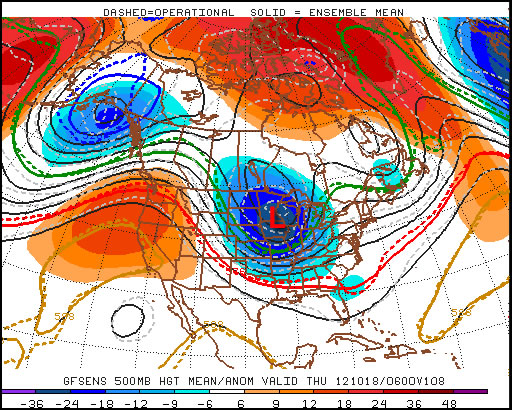
A frontal wave pushes across Southern Manitoba on Sunday, occluded from the parent low that will be captured over Northern Saskatchewan by an upper low in the area. Some uncertainty exists to the amount of precipitation associated with this wave as it moves through. Some models have next to no precipitation, while the GDPS is suggesting as much as 10-15mm of rain. My personal feeling is that we’ll likely see some rain push through with general amounts in the 4-8mm range across much of the RRV. We’ll keep an eye on this system and provide some updates through the weekend in the comments below. Sunday will likely be mostly cloudy again, with a high near 10C.
The biggest weather feature next week looks to be the potential for a significant low pressure system to push into North Dakota, bringing rain, snow, and potentially blizzard conditions to the Red River Valley for the second half of the week. That’s a long ways away, though, and a lot can change between now and then. We’ll be sure to follow this potential system closely through the week ahead.