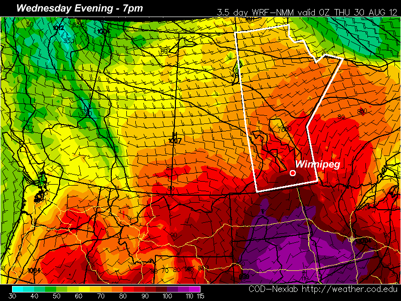
Showers and Unsettled Weather

Showers will be the story of the day in Winnipeg as an upper trough swings into the RRV today. A band of showers will push in this morning and entrench itself as a low pressure system pushing northwards out of the United States reinforces the area of rain parked over the Red River Valley.

An upper low has pushed into Alberta, drenching the province in rain and snow, with some areas expecting 30-40mm of rain while some regions in the Foothills are getting 10-20cm of snow. For us here in Manitoba, a band of rain running along a line from Dauphin to Grenta to Grand Forks will push over the entirety of the Red River Valley and stall out. In Winnipeg, we’ll get up to around 10°C today with a blustery southeast wind. Showers will slowly weaken in the afternoon before reintensifying as a low pressure system lifts northwards out of North Dakota in the evening. Precipitation will blossom as the entire system spins up and strengthens with cooler air beginning to slump southwards across the Prairies on the backside of the main surface low.

Accumulated QPF valid Saturday Evening

Total accumulated precipitaiton from the GEM-REG model valid from 00Z today through 00Z Sun 15 April (Saturday evening). This image is what the GEM-REG model believes the 2-day rainfall totals will be.

The showers will clear out from Winnipeg on Saturday morning leaving us with a mix of sun and cloud and a daytime high around 12°C. Things cloud up again on Saturday evening as band of scattered showers pushes southwards along the cold front. We’ll be left with sunny skies on Sunday with a high near 10°C.

Total rainfall through the next few days will vary depending on exactly how much convection ends up embedded within the rain, and we’ll only be able to tell that as things develop. In general, though, the following are the expected amounts:

  • Winnipeg: 10-15mm
  • Altona: 10-20mm
  • Emerson: 10-20mm
  • Morris: 10-15mm
  • Steinbach: 10-15mm
  • Winkler: 15-25mm

Areas in Southwestern Manitoba, including Brandon, Pilot Mound, Melita and Virden will see greater amounts than locations in the RRV, with general accumulations around 1”. As usual, we’ll have updates in the comments below!

Warmer Weather To Round Out The Week

Southern Manitoba will see a much more pleasant second half to the work week as an Arctic high pressure system exits the region and allows warmer air to return to the region. Temperatures will moderate and rise to above normal by Friday before a complex weather setup brings showers this weekend.

Southern Manitoba has seen the coldest weather we’ve seen in quite a while. Sunday’s maximum temperature of -0.7°C was the coldest day we’ve had since the mercury topped out at -3.9°C on March 9th. The high pressure system responsible for the cooler temperatures brought a record daily overnight low temperature to Wynyard, SK on Monday morning where the temperature bottomed out at -18.0°C which beat out the old record of -15.6°C set in 1940 (records for Wynyard, SK began in 1940).

700mb Temperatures valid Wednesday Evening

700mb temperatures valid 00Z Wednesday Evening

With the main ridge axis through the Red River Valley, winds will begin to pick up out of the SE today as warmer air pushes in aloft. This, combined with plenty of sunshine, should allow our temperatures to rebound nicely to around 7°C this afternoon. Warm air will continue to push into our region in advance of an upper low trundling into the northwestern United States and push our daytime high up into the mid-teens for Thursday.

The weather will take a turn on Friday as showers develop overnight Thursday and push into Southern Manitoba Friday morning. Currently it looks like we’ll see just some light showers; remants of nocturnal convection from North Dakota moving along with an area of lift associated with a dying surface low. What actually happens will depend significantly on how the rain develops in North Dakota, so we’ll be sure to keep an eye on that. For now, enjoy the next couple days! Just don’t forget a jacket out there for this morning, it’s chilly!

Chilly Start to the Week

We are about to get our first taste of below-normal weather in quite some time. Temperatures on Monday and Tuesday are expected to be several degrees colder than the seasonal average.

GEM model high temperature forecast for Monday

GEM model temperature prediction for 4pm on Monday

High temperatures on Monday are expected to hover around the zero mark in much of Southern Manitoba. Combined with a brisk north-west wind, conditions on Monday will be rather cool. If you consider the wind chill, it will feel closer to -6 on Monday afternoon (calculated using a temperature of 0C and wind speed of 25km/h). Tuesday won’t be much warmer, with highs only expected to creep up in the low single digits. The wind will be lighter on Tuesday, making it feel significantly warmer than Monday…although it will still be chilly. Both Monday and Tuesday are expected to be mainly cloudy, which will also hold our temperature back. If the sun does come out in some areas on a localized basis it will be slightly warmer. In early April the normal high is about 8 degrees in Southern Manitoba, meaning most areas will be between 4 and 8 degrees colder than normal through the first two days of the week. Models show a gradual improvement in temperatures as we move later into the week. By Wednesday we should get up into the high single digits and by Thursday the double digits will become likely.

In the longer range it appears that next weekend could be a bit unsettled. At this time models show a low pressure system moving up into the Northern Plains, spreading rain across a large area, which may include Southern Manitoba. It is too early to say if this system will affect us at all, but it is something to watch.

Looking even further ahead it appears we are in for a period of more normal weather. Longer range guidance is hinting at normal to slightly above normal weather for the next couple weeks. There is also some indication that our weather may remain somewhat unsettled, which is fairly typical for this time of year. Wouldn’t it be something if the first half of April was cooler than the second half of March!


Elsewhere in Weather News

Intense Low Affects Japan

A very powerful low pressure system made landfall in Japan on Tuesday, April 3rd and brought with it incredibly strong winds and much rain. This storm, believed to be the strongest storm to hit Tokyo since 1959, generated 90km/h sustained winds and 150km/h wind gusts at times (highest gust reported in Niigata prefecture, 156.6km/h), in the western part of Japan. Rain rates of over 60mm/h also fell associated with the squall line as it moved across most of Japan’s main island. This caused more than 20,000 homes to lose power, various buildings to collapse and trees to fall – causing 97 injuries and 4 deaths. Flight cancellations and railway closures also had to be taken into mind when traveling, as more than 600 flights were cancelled departing from Japan. The very strong winds resulted in trucks being flipped over on the highways and bridge closures, bringing the traffic to a crawl. Waves of 10m were experienced off the coast, however it was strongly advised to stay inside.

Image of the powerful low centered over the Sea of Japan (East Sea), as and after the squall line passed it produced very high winds. (Source: The Watchers/Japan Meteorological Agency)

Image of the powerful low centered over the Sea of Japan (East Sea), as and after the squall line passed it produced very high winds. (Source: The Watchers/Japan Meteorological Agency)

A high-pressure has since moved into place giving way to sunnier skies with some stronger winds associated with it.

Texas Tornadoes

This past week brought very active weather not only in Japan, but also the US, where violent tornadoes hit populated areas of Texas and caused significant damage. Two supercells dropped tornadoes simultaneously on the afternoon of April 3rd in the Fort Worth and Lancaster areas, causing the most significant damage. Preliminary estimates rate these tornadoes between EF-2 and EF-3, where winds are measured at 177km/h to 266km/h. Tornado warnings had been posted by the National Weather Service well before the storm hit allowing residents to take the necessary precautions; although significant damage was caused to neighbourhoods and industrial parks it could have been much worse. Ten injuries and no deaths were reported, the Dallas mayor called it “miraculous” to see that the numbers weren’t more significant after a big damage path could be seen from aerial view.

Tractor-trailer picked up by the tornado in the Dallas/Fort Worth area. (Source: Reuters/NBC)

Tractor-trailer picked up by the tornado in the Dallas/Fort Worth area. (Source: Reuters/NBC)

Tornadoes had not been the only culprit to cause significant damage that day, as very large hail was also reported with this storm. Hail damage to 100 airplanes at the Dallas airport was reported, with issues ranging from minor inspection needed, to planes being put out of service indefinitely.

Lancaster (just south of Dallas) tornado information, with RADAR captures. (Source: NWS storm reports)

Lancaster (just south of Dallas) tornado information, with RADAR captures. (Source: NWS storm reports)

This week, more storms are expected in Texas and most of the Plains, as the jet stream remains south of the border and systems push through Tornado Alley.

Elswhere in Weather News has been provided by Matt

Springtime Low to Bring Cooler Weather This Weekend

A low pressure system tracking through western and central Manitoba will bring unsettled weather, cooler temperatures and windy conditions to the Red River Valley this weekend…but not before one more beautiful day.

Forecast surface temperatures

Forecast surface temperatures for mid-afternoon today.

Conditions will be fairly uniform across the Red River Valley today with plenty of sunshine, highs near 20°C and a stiff southerly wind blowing at 40 to 50km/h. It’s a fitting end to another simply beautiful, and above normal with regards to the temperature, week. Tonight, a low pressure system will eject out of southeast Saskatchewan across Parkland Manitoba and into the Interlake. Associated with this low is a very strong 40kt low-level jet (LLJ), however a lack of moisture and unimpressive mid-level lapse rates should erase any concerns (or hopes) of nocturnal convection.

A cold front will sweep across the Red River Valley on Saturday morning, bringing a chance of showers to most regions; indications are that areas east of the Red River will see a greater chance of a shower or two than areas west. After the passage of the cold front, the entire RRV will be left with a fairly strong westerly wind and cloudy skies.

Accumulated Precipitation

Total accumulated precipitation from 00Z Friday to 00Z Monday. This shows the relative lack of precipitation over SW Manitoba and the RRV; a stark contrast to the copious amounts of precipitation that are forecast over Eastern Saskatchewan and Western Manitoba.

The wrap-around precipitation will begin to move into the RRV on Saturday night, coincident with colder air diving southwards on the backside of the low. Current indications are that the precipitation will fall as snow and that the northern half of the RRV has a much greater chance of seeing flurries than the southern half. The low continues to lift NE through the day Sunday, pulling the wrap-around northwards with it and out of the RRV. It will be a struggle between the main area of lift pulling north and remnant moisture and instability in the cooler air left in the RRV. Most areas in the RRV will likely see a little bit of snow on Sunday, however the only areas that might accumulate a cm or two would be north of Morris.

All in all, we’re being spared with this system, as large amounts of precipitation are forecast from the Moose Jaw/Regina, SK region along a line NE to Swan River and The Pas. The GEMGLB is currently painting up to 75mm of precipitation, which if that were to all fall as snow would likely end up as 1-2 feet of the white stuff. We’ll see how much actually falls, though, as the GEMGLB can have problems with convective feedback in situations where embedded elevated convection is a possibility along a warm front. Anyone planning to travel to Saskatchewan today or on the weekend should make sure they check road conditions and weather forecasts for cities/towns along their route before they leave.

After that things clear out for the start of next week and our temperatures rebound back into the low teens by midweek. Things are looking like we’ll have continued sun and warm temperatures into next weekend as well.