Isaac Threatens Southern States
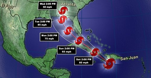
This past week a tropical disturbance in the central Atlantic, east of the Caribbean, has strengthened into a tropical storm – Isaac. As of Friday night, Isaac had sustained winds of 112km/h, a central pressure of 990mb and was eyeing (no pun intended) Haiti. It is especially worrisome that Isaac, a strong tropical storm, is moving towards one of the most impoverished countries in the world, where nearly 400,000 people are still living in tents after the major earthquake back in 2010.
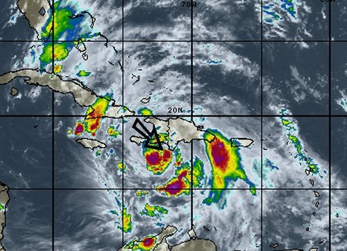
Isaac will make landfall as a strong tropical storm as it crosses Haiti and then heads toward Cuba. It might have trouble sustaining its strength due to the mountainous terrain of the islands but as it emerges into the Gulf of Mexico, Isaac should organize itself quickly as it takes aim at the Gulf States such as Florida, Alabama, Mississippi and Louisiana. It is expected that Isaac will make landfall on American soil, somewhere on the western part of the Florida Panhandle on Tuesday afternoon. By that time Isaac will have intensified enough to be of hurricane strength, most likely category one. Residents of the Gulf States will have to monitor conditions closely to secure items outside and be ready to evacuate; storm surge along the coast and flooding because of the heavy rains is likely to occur. It will not be uncommon to see rainfall amounts of 100-200mm in the hardest hit areas in the Caribbean and US, however, the more rugged terrain of the islands on the Caribbean could have more devastating effects; landslides and flash flooding.
In other news around the world, Taiwan has been hit with yet another storm – typhoon Tembin that had sustained winds of 155km/h but struck a less populated area of the country, leaving the large cities like Taipei with only minor flooding and wind damage.