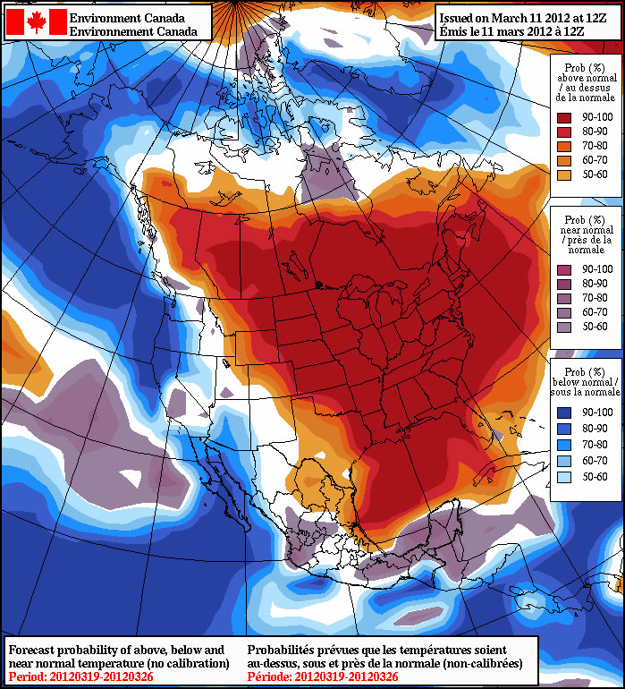
Winnipeg will see a record-breaking weekend ahead with potentially unprecedented heat on the way. 3 daily record high temperature records have already been broken this week, and at least another 3 will be broken over the next few days. In fact, there’s also a chance that we’ll see warmer weather by the beginning of next week than we’ve ever seen in March.
March has been nearly unprecedentedly warm this year, with temperatures quickly soaring 10-15°C above normal after a decidedly unpleasant snow storm started the month with more than 6” of snow in many locations. Plenty of uncertainty existed as to how warm it could get with so much snow on the ground, but extremely warm air aloft combined with light winds (and a few breezy days) have done an incredibly good job at eroding the snow pack over Southern Manitoba. The following slides show the quickly eroding snowpack over a mere 4 days:
-

Evening of March 11th
-

Evening of March 11th
-

Evening of March 12th
-

Morning of March 13th
-

Evening of March 13th
-

Morning of March 14th
-

Evening of March 14th
-

Morning of March 15th
$(window).load(function() {
$(‘.flexslider’).flexslider();
});
In a mere couple days almost all the snow disappeared from Southern Manitoba, quickly negating it’s potential to hold our temperatures back. As a result, we’ve broken several daily high temperature records this week, and are on track to break several more.
| Day | New Record |
Old Record |
Previous Record Year |
|---|---|---|---|
| Sun Mar. 11 | 12.8°C | 12.5°C | 1981 |
| Mon Mar. 12 | 9.7°C | 7.2°C | 1922 |
| Thurs Mar. 15 | 14.4°C | 11.1°C | 1927 |
| Fri Mar. 16 | 19.9°C | 12.4°C | 1981 |
| Sat Mar. 17 | 19.2°C | 12.8°C | 1938 |
| Sun Mar. 18 | ??.?°C | 14.4°C | 1910 |
| Mon Mar. 19 | ??.?°C | 18.9°C | 1938 |
So where’s this warmth coming from?

As a long-wave trough approaches the west coast, a strengthening southerly flow will begin to advect plenty of heat and, surprisingly, moisture into the Northern Plains and Southern Manitoba. This will be enhanced by the record-shattering heat that’s been in place over the Central and Eastern US already, putting us within a stone’s throw of breaking another substantial record: the warmest day ever recorded in March in Winnipeg.
We’ll see exceptionally warm temperatures over the next few days:
- Today: 22°C
- Saturday: 18°C
- Sunday: 21°
- Monday: 25°C
These forecast highs will definitely put us in some of the hottest days ever in March in Winnipeg:
The top 3 hottest days ever recorded in Winnipeg in March are:
- March 27, 1946: 23.3°C
- March 23, 1910: 22.8°C
- March 28, 1938: 20.6°C
Monday will give us a decent shot at breaking the all-time hottest day ever in March in Winnipeg, but we’ll see how that goes a bit closer to the day. Today and Sunday will definitely find a place in that list, though.
And last but not least, there exists a chance for thunderstorms! Sunday night brings with it a chance of thunderstorms overnight. Several of the ingredients we look for to predict nocturnal thunderstorms are in place:
- Moisture: Dewpoints at 850mb are progged to be ~ 15°C
- Instability: Models vary, but we could see around 1000 J/kg of MLCAPE Sunday night.
- Shear: We’ll have shear galore: 50-60kt of 0-500mb bulk shear
- Trigger: An advancing warm front.
The cap may be a concern, and there may not be quite enough instability to get things going; there is certainly a non-zero chance though. We’ll keep updates on temperature records and the chance for thunderstorms in the comments as the weekend progresses!