Hot And Smoky in Winnipeg

Winnipeg will see more smoky weather as an upper ridge sends temperatures soaring.

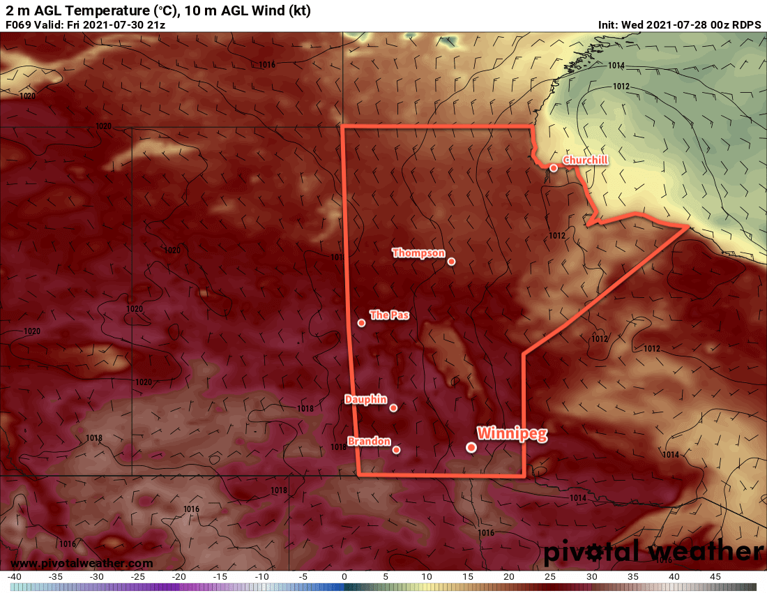
Winnipeg will see several days ahead with highs climbing above 30 °C as a potent upper ridge pushes eastwards across the Prairies. With the upper ridge will come broad subsidence and mainly sunny skies over the next few days.

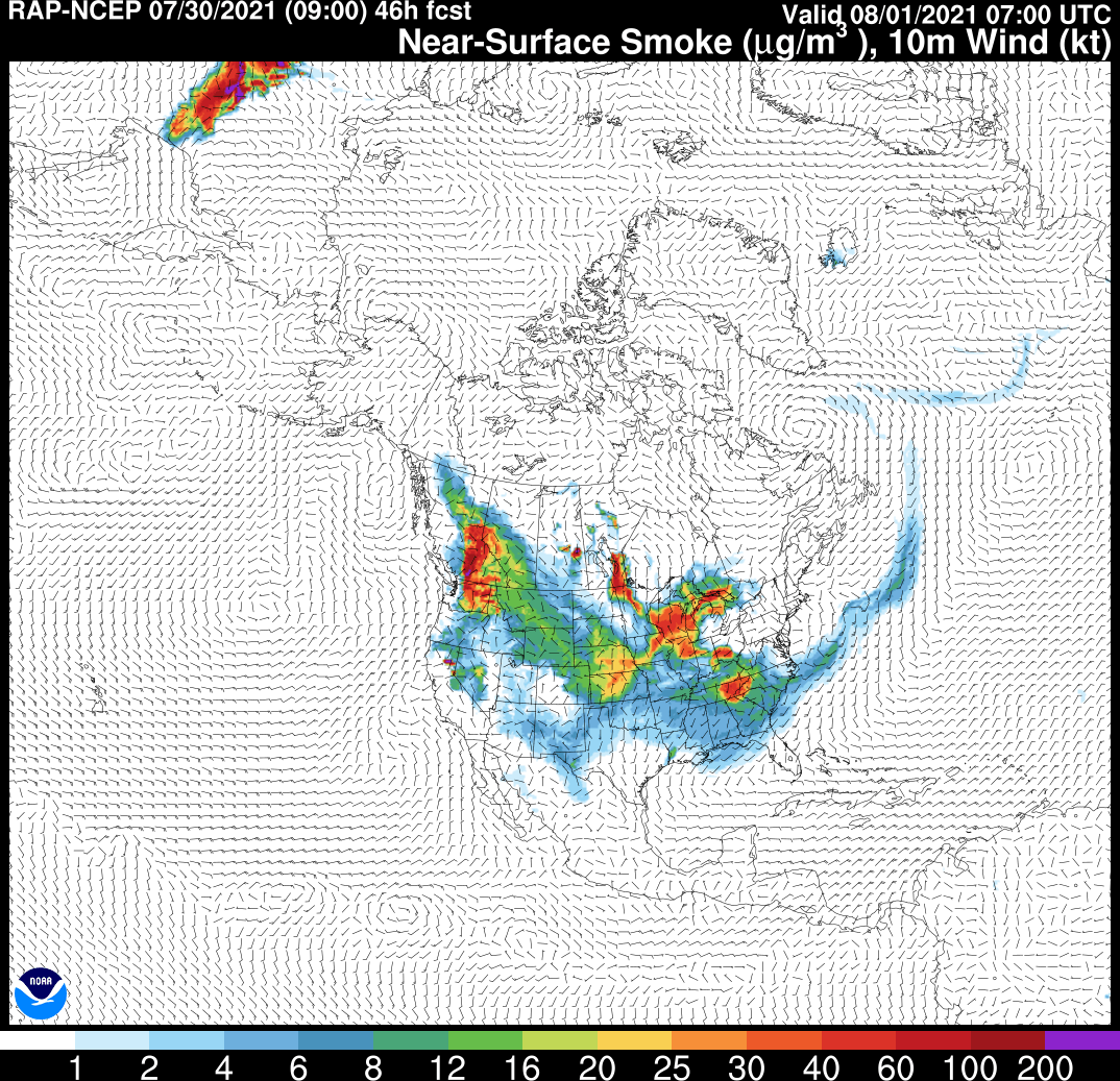
Unfortunately, Winnipeg will continue to see periods of smoke as well. Conditions will likely be worst today, improve for tomorrow, then degrade a bit again on Wednesday.

RDPS 2m Temperature Forecast valid 21Z Tuesday August 3, 2021
Winnipeg will see very warm temperatures on Tuesday with highs in the 30s.

Overnight lows will be seasonably warm, though it will be a very warm night on Tuesday night when the warmest air is over the region.

It will stay dry over the next few days, but a few showers or thunderstorms may be possible later Wednesday. A low pressure system will be dropping southwards into the region and may trigger more scattered thunderstorms.

Long Range Outlook

Winnipeg will see a return to seasonal temperatures in the second half of the week with variable cloudiness. There might be a small chance of some showers, but no notable rainfall is likely.

Today’s seasonal daytime high in Winnipeg is 26 °C while the seasonal overnight low is 13 °C.

Smoky Weekend Ahead for Winnipeg

A high pressure system building across the Prairies will spread wildfire smoke into the Red River Valley and southeastern Manitoba this weekend.

Winnipeg will start the day off with hazy conditions and a southwest wind of 20–30 km/h. Temperatures will warm to a high near 30 °C this afternoon with winds gradually shifting to the northwest as a trough slumps southwards. There will be a slight chance for showers or a thunderstorm in the latter half of the afternoon, but the activity will be more likely to develop south of Winnipeg.

Beginning tonight, Winnipeg and area will see northerly winds ahead of an approaching high pressure system. They’ll pick up to 30 gusting 50 km/h on Saturday and stay relatively light on Sunday. But through the weekend these winds will draw forest fire smoke southwards from several fires burning across the region. Thick plumes of smoke will move through the region over the coming days. They will produce reduced visibilities and very poor air quality.

RAP-SMOKE Near-Surface Smoke Forecast valid 07Z Sunday August 1, 2021
Portions of the Red River Valley along with all of southeastern Manitoba will see dense smoke plumes at times this weekend from wildfires burning east of Lake Winnipeg.

For Winnipeg, two significant air quality events are forecast to occur. The first will start tonight into Saturday morning and the other will begin Saturday evening into Sunday morning. Both of these events are likely to produce extremely poor air quality. While there will be some measure of improvement between them, that isn’t to say that air quality will become “good”. It is likely that much of the Red River Valley and southeastern Manitoba will see generally poor air quality through the coming weekend. Some improvement is likely into next week as the winds begin to shift.

While the skies won’t have many clouds on Saturday or Sunday, there will be a layer of smoke aloft blanketing the region much of the weekend. Highs will climb into the upper 20s with lows in the low to mid teens.

Long Range Outlook

An upper ridge will amplify over the Prairies later in the weekend and gradually shift east through next week. This will likely bring an improvement to Winnipeg’s smoke conditions, but will also bring very warm temperatures into the region. Winnipeg will likely see highs in the upper 20s or low 30s through much of next week with dry conditions.

No significant rainfall is in the forecast; combined with the week of warm weather ahead, the drought situation over southern Manitoba will continue to worsen.

Today’s seasonal daytime high in Winnipeg is 26 °C while the seasonal overnight low is 13 °C.

Warm, Dry Weather Continues

Despite a couple chances for thunderstorms in the days ahead, generally warm and dry weather continues in Winnipeg.

A disturbance tracking across southern Manitoba will bring mixed skies to start the day in Winnipeg. The city will see a chance of an early morning shower or thunderstorm as overnight convection pushes eastwards. The morning will stay relatively humid with temperatures quickly climbing towards the day’s high near 30 °C. A cold front will drop south through the Red River Valley mid-day, and there is a small chance of a couple more showers or thunderstorms developing as it moves through. Moderate northerly winds around 30 gusting 50 km/h will move into the Red River Valley behind the front for the afternoon. Skies will clear out through the afternoon as the winds usher in less humid conditions.

Winnipeg will see clear skies, light winds, and a low near 15 °C tonight.

Tuesday will be another beautiful summer day with plenty of sunshine and a high near 28 °C. Humidity levels will be comfortable and a ridge of high pressure will keep the northerly winds lighter in the 15–25 km/h range. Some cloud will begin to build into the region overnight ahead of a warm front pushing into the region. This will keep the overnight low warmer near 18 °C.

RDPS 2m Temperature Forecast valid 21Z Friday July 30, 2021
Southern Manitoba will once again see high temperatures near 30 °C on Wednesday.

The city will see mixed skies on Friday with a chance of showers or thunderstorms as a disturbance tracks across the province. The best chance for any precipitation will happen in the afternoon when the warm-sector trough moves through the Red River Valley. Conditions will stabilize into the evening with clearing skies and temperatures heading to a low near 16 °C.

Long Range Outlook

The weekend ahead will be mainly sunny and dry with near-seasonal temperatures. The region may see a bit more cloud next week with temperatures climbing back towards the 30 °C mark.

Today’s seasonal daytime high in Winnipeg is 26 °C while the seasonal overnight low is 13 °C.

More Warm Weather With a Chance of Showers

Temperatures will stay warm in Winnipeg through the first half of the week and the city may even see a bit of rain.

Today will start off with mixed to cloudy skies as a band of showers makes its way across southern Manitoba. This band developed overnight and may bring some rain to Winnipeg; as of writing, the band hasn’t formed yet so its exact placement is unknown to me!). It will be a narrow band situated just north of an upper-level front draped across the province. There may even be a chance of a thunderstorm. Any rain should push off to the east by midday, leaving the city with partly cloudy skies. Temperatures will climb to a high near 28 °C with northeasterly winds picking up into the 30–40 km/h range.

These winds will tap into some of the forest fire smoke from east of Lake Winnipeg, reducing air quality on Monday night into Tuesday. It shouldn’t be anywhere near as a bad as the last smoke event, but will be enough to be noticeable.

Temperatures will dip to a low near 14 °C tonight with clear skies and easing winds.

An approaching low pressure system will push temperatures higher on Tuesday with the high in Winnipeg in the low 30s. Skies should stay mainly clear for much of the day but some cloud will build into the region by late afternoon. The winds will stay light through the morning, then pick up out of the south into the 20–30 km/h range by the end of the afternoon.

RDPS 2m Temperature Forecast valid 21Z Tuesday July 27, 2021
Hot weather will return to southern Manitoba on Tuesday.

Heading into the night, nocturnal thunderstorms will likely develop over western Manitoba and push eastwards. Winnipeg will see a chance for some of that activity overnight into early Wednesday morning. Temperatures will head to a low near 19 °C with southeasterly winds near 30 km/h.

Skies will gradually clear out on Wednesday with northwest winds near 30 gusting 50 km/h and a high near 29 °C. The winds will ease on Wednesday night with a low near 17 °C.

Long Range Outlook

Warm weather will continue for the rest of the week with another chance for some showers or thunderstorms on Friday. After that, temperatures will return to seasonal values with variable cloudiness through the weekend into next week.

Today’s seasonal daytime high in Winnipeg is 26 °C while the seasonal overnight low is 13 °C.