Mixed Bag Ahead

A bit of a grab bag of unexceptional weather is on it’s way for Winnipeg and the Red River Valley as the cold air’s grip loosens ever so slightly before returning to the region, bringing flurries with it.

Wednesday
-18°C / -25°C
Mixed skies; chance of flurries.

Thursday
-12°C / -20°C
Warmer; cloudy end to the day with some flurries.

Friday
-14°C / -23°C
Mixed skies; chance of flurries.

We’ll see mixed skies today as patchy low cloud continues to stream southwards out of the Arctic across the Prairies. Any of this cloud has the slight chance of producing some fairly insignificant flurries. Our temperature will remain cool today with a high of around -18°C and will drop to around -25°C tonight.

Tomorrow will bring warmer weather as a fairly strong low pressure system moving over Southampton Island manages to push some slightly milder air through the Northern Prairies and southeastwards into Southern Manitoba. We’ll see temperatures climb up to a near-normal high of -12°C or so with mixed skies before the clouds thicken up through the afternoon and some flurries slide into the Red River Valley and southeastern Manitoba. No significant accumulations are expected.

Friday will bring mixed skies once again with a chance of scattered light flurries. Temperatures will only cool off slightly thanks to the cloud cover and we’ll see a high of around -15 or -14°C. Temperatures will drop off to around -23°C or so overnight under mainly clear skies.

Continued Below-Normal Temperatures

The NAEFS 8-14 day temperature outlook is beginning to show signs of near-normal temperatures returning.

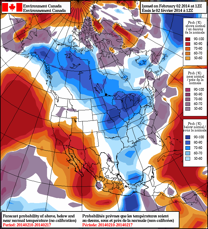
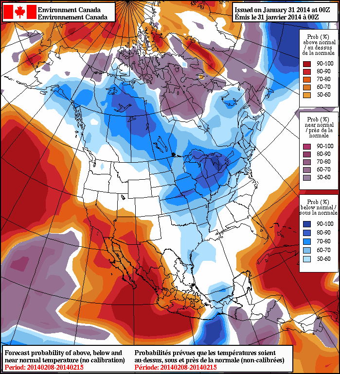
Unfortunately, it’s still looking like below-normal temperatures[1] will persist through Southern Manitoba for at least the next week or two. A persistent northerly/northwesterly flow is showing no signs at all of breaking down and will continually reinforce the Arctic air in our region, maintaining the cool weather. While we may see short-lived near-normal breaks, the overall trend will be decidedly cool through the next two weeks. No significant snowfall events are expected through the next week.

Once we hit the 1.5 to 2 week mark, though, things are starting to look like they might begin to moderate a little bit and we might climb a lot closer to normal for mid-February. Any warm-up would likely mean a return to snowier weather as well, so we may see a stormier end to the month than we’ll see through the first half.


  1. The normal daytime high at this time of year in Winnipeg is -10°C. The normal overnight low is -21°C.  ↩

More of the Same

This week will feature more of the same cold weather we’ve seen lately. I’m sure you’re about as enthused to read that as I was to write it.

Early Week Outlook

Monday
-15°C / -30°C
Mix of Sun and Cloud
Tuesday
-18°C / -29°C
Mainly Sunny
Wednesday
-18°C / -26°C
Mainly Sunny

Today will feature slightly below normal temperatures[1]. Highs will be in the mid to upper minus teens in southern Manitoba with fairly light winds. As a result, the wind chill won’t be a big factor.

Tuesday will be a bit cooler than Monday, but not by a whole lot. Temperatures will sit around -20C with wind remaining relatively light once again.

Wednesday will be close to a carbon-copy of Tuesday. The wind will be a bit stronger on Wednesday though, so you may notice the wind chill factor a bit more – but values aren’t expected to reach “extreme” [2] criteria.

Long Range

The long range forecast calls for continued cold weather.

The long range forecast calls for continued cold weather.

The long range forecast continues to look bleak. Models suggest below-normal temperatures will last through most of the first half of February. There has been some rumblings that the second half of February may feature warmer weather, but that remains to be seen. For the time being, we will remain locked in a cold pattern.


  1. The normal high for this time of year is -10°C and the normal low is -21°C.
  2. Extreme being -40 or colder

Below-Normal Temperatures Continue

Those looking for a balmy reprieve from winter are going to have to look into buying plane tickets because there is no end in sight to the below-normal temperatures that have settled in over the region. A very stable pattern has developed which anchors us into a north/northwesterly flow and will continue to tap cold Arctic air and funnel it southwards over the Prairies.

Friday
-18°C / -25°C
Mixed skies.

Saturday
-18°C / -27°C
A few clouds.

Sunday
-17°C / -25°C
A few clouds.

Quiet Weather Ahead

A very quiet few days are ahead of us with little in the way of active weather on tap. A weak cold front is pushing southwards through the province today, and while it’s possible some snow happens, if it were to it wouldn’t really amount to more than a few flakes and definitely wouldn’t accumulate to anything. Here in Winnipeg and areas south the best chance for that is overnight, but it’s so minimal that I don’t really feel it bears any more mention than.

After that, there’s no snow expected through the remainder of the weekend. Temperatures will generally sit around -18°C for highs and -25°C for lows with variations a couple degrees off those points. Winds are also expected to be light with nothing climbing over 20-25km/h through the next few days.

Cold Weather Here to Stay

While it’s not nearly as cold as it was through December or many parts of this month, our temperatures are still noticeably below the “seasonal”[1] -11°C for this time of year. Thanks to that persistent northerly flow thanks to a complex of lows anchored over Hudson Bay, it doesn’t look like much change is in sight.

The NAEFS is forecasting below-normal temperatures through the 8-14 day timeframe.

The North American Ensemble Forecast System (NAEFS) continues to forecast below-normal temperatures in the 1-2 week timeframe; unfortunately for us, this outlook tends to be fairly accurate most of the time. At this rate, it means that we’ll see little hope for improvement at least until the middle of February.

So, do what Winnipegers are great at doing: make lemonade. Enjoy the fact there won’t be much wind, bundle up and get out there!


  1. It should probably be noted that – especially in January – the “normal” temperatures tend to be averages between the extremes thanks to our continental climate.  ↩

Extreme Cold on The Way Out

A clipper system tracking through Southern Manitoba today will bring near-normal temperatures and a very slight chance of a flurry through the early afternoon. Once the system passes through, we’re going to settle into a fairly stable pattern as a dome of cold air settles over Hudson Bay, keeping us in a benign but cool pattern for the remainder of the week.

Wednesday
-11°C / -25°C
Cloudy; a marginal chance of midday flurries. Clearing later in the day.

Thursday
-20°C / -25°C
Mainly sunny.

Friday
-18°C / -22°C
A few clouds.

Today will bring relatively mild weather as temperatures climb up to -11°C or so thanks to a weak clipper system tracking through Central Manitoba that is dragging some warmer air with it as it pushes through. We’ll see mainly cloudy conditions through the morning and early afternoon with clouds then clearing out late in the afternoon or early this evening. There’s a very slight chance of a flurry or two starting midday and through the early afternoon, but the risk is very slight at that. Any organized snowfall should remain to our north and to our east, but even there only around 2cm is expected. By mid-afternoon there will be essentially no threat of snow and the clearing will begin.

This 700mb temperature chart for Saturday evening shows the dome of cold Arctic air set to settle over Hudson Bay.

As the clipper system pushes off into Ontario, cooler air will begin filtering into Manitoba. We’ll see temperatures drop to around -25°C tonight with a modest recovery to around -20°C tomorrow under mainly sunny skies. The temperature will drop to around -25°C once again tomorrow night under clear skies. Friday looks to climb a little bit warmer to around -18°C with some afternoon clouds as a very weak disturbance whips across the province. Slightly warmer air aloft will bump up our overnight low a few degrees to around -22°C or so under clear skies once again.

More of the same (perhaps cooling off a little) is in store for the weekend. No significant snowfall events[1], in Winnipeg or the Red River Valley, are expected right through to the end of next week.


  1. “Significant” in this case meaning 2cm or more.  ↩