More Mild Temperatures Ahead

Winnipeggers will be able to continue easily enjoying the outdoors with temperatures over 10 °C above seasonal averages.

Today will start off with a low pressure system that moved into the region yesterday exiting eastwards into Ontario. As it pushes off, Winnipeg will see mainly sunny skies and westerly winds of 20–30 km/h. Temperatures inch up to a high near +1 °C through the day as the winds gradually ease. The city should see clear skies tonight with a low near -13 °C as a ridge moves through.

On Tuesday, an upper trough will move into Saskatchewan, spreading cloud cover eastwards ahead of it into Manitoba. Winds will shift to the southeast ahead of a surface low, but should stay light through the day. Temperatures will be a tad cooler as ridging remains across the region and Winnipeg will see a high near -3 °C. Skies will be mostly cloudy on Tuesday night with a low near -5 °C.

RDPS 2m Temperature Forecast valid 21Z Tuesday January 5, 2021
Mild temperatures will persist across the southern Prairies this week.

Wednesday will bring little change across the region as Winnipeg finds itself on the edge of a col. A col is an area of light winds found where a trough and a ridge intersect. In our case, the trough will run from Alberta southeastwards to a low over Iowa, and the ridge will run from NW Ontario southwestwards towards Idaho. As a result, any cloud left from Tuesday night should just stick around and give mostly cloudy skies. Winds will be light and temperatures should climb to a high near -1 °C. Skies will stay on the cloudier side on Wednesday night with a low near -4 °C.

On both Tuesday and Wednesday, the cloud cover could produce some periods of light snow, but accumulations would be insignificant. If it happens, the snow would be light enough that it’s only really worth mentioning in passing.

Long Range Outlook

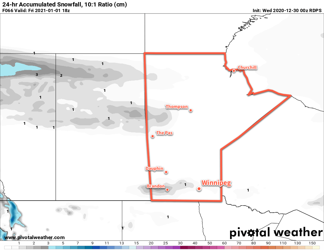
Mild temperatures with conditions trending cloudier will continue through the week. The next chance for any organized snowfall looks to be on Friday night when an occluding frontal wave could bring a couple centimetres of snow to the region.

Today’s seasonal daytime high in Winnipeg is -13 °C while the seasonal overnight low is -23 °C.

Mild Winter Weather Continues Into The New Year

Winnipeg’s seasonably mild temperatures will persist into 2021.

Winnipeg will see a fair amount of cloud today as stratus behind yesterday’s disturbance struggles to clear from the region. A weak ridge will move into the region this afternoon, slowly pushing the clouds eastwards and keeping winds light. A few clear breaks may develop late this afternoon, but more cloud cover will develop over the region tonight. Temperatures should reach a high near -7 °C and fall to a low near -15 °C tonight. Winds overnight will pick up out of the south into the 15–25 km/h range.

On Thursday, a low moving through the northern Prairies will push a trough eastwards into the Red River Valley. Winds will persist out of the south at 15–25 km/h through the day with temperatures climbing to a high near -7 °C. Winnipeg should see sun to start the day, but some clouds will work into the region by late afternoon. Skies will stay on the cloudier side overnight with a low near -12 °C. There will be a chance for a bit of light snow overnight to ring in the new year the trough passes.

RDPS 24 hr. Snow Accumulation Forecast (at 10:1 SLR) valid 18Z Friday January 1, 2020
Winnipeg may see a dusting of light snow on Thursday night to ring in 2021.

2021 will kick off with a ridge of high pressure will moving across southern Manitoba, bringing light winds and clearing skies. Temperatures will again climb to a seasonably mild -8 °C. Some more cloud will push into the region on Friday night as a warm front pushes towards the region. Temperatures will dip to a low near -11 °C with wins picking up out of the south to around 20 km/h.

Long Range Outlook

Even warmer weather will push into the region this weekend with temperatures climbing back to the freezing mark — or even above — and sticking around through much of next week. A gradual return of highs back into the mid-minus single digits is forecast for the latter half of next week. No significant snow is expected through the week.

Today’s seasonal daytime high in Winnipeg is -13 °C while the seasonal overnight low is -23 °C.

Temperatures Remaining Above-Normal in Winnipeg

Winter will continue to be MIA as daytime highs continue to climb above freezing this week.

Another broad upper ridge spreading across the Prairies will keep mild Pacific air in place over the region.

To start the day, Winnipeg may see a bit of cloud or fog. If it does show up, things should clear out relatively quickly and leave behind mainly sunny skies. Temperatures will climb to a high just above 0 °C. The city will see light westerly winds through most of the day. More cloud will spread through the region tonight with lows dipping to around -4 °C.

On Tuesday, the city will see a few more clouds as a trough moves across the region. Winds will pick up out of the west midday behind the trough into the 20–30 km/h range. Once those westerlies kick in, temperatures should jump nicely for the afternoon and reach a high near +4 or 5 °C. Skies will mostly clear tomorrow night with winds easing and a low near -3 °C.

RDPS 2m Temperature Forecast valid 21Z Tuesday December 8, 2020
All of southern Manitoba will see mild temperatures climbing above freezing on Tuesday afternoon.

Temperatures will again climb above freezing to a high near +3 °C on Wednesday in Winnipeg. The city will enjoy partly cloudy skies with westerly winds picking back up into the 20–30 km/h range. More cloud will work into the region on Wednesday night with easing winds. The city should see a low near -3 °C again.

Long Range Outlook

The latter half of the week will likely see a fairly large pattern shift that will usher a return to more wintery conditions to the region. Forecasts show s strong winter storm moving from the Dakotas through Minnesota and into NW Ontario on Thursday through Saturday. This system will likely graze across portions of southern Manitoba and may bring accumulating snow to the region.

Behind this system, the upper ridging will over western North America will collapse, and the Polar Vortex will strengthen and slump into southern Nunavut. This will allow cooler air to spill southwards out of the Arctic and return temperatures closer to seasonal values for the weekend into next week. Winnipeg will likely see daytime highs in the -6 to -12 °C range this weekend and into the first half of next week. Overnight lows are forecast to dip into the mid-minus teens.

Today’s seasonal daytime high in Winnipeg is -8 °C while the seasonal overnight low is -17 °C.

Nothing But Warm Weather Ahead

A broad upper ridge over western Canada will keep temperatures well above seasonal averages in Winnipeg.

Today will be the coolest day of the next week in Winnipeg as a bank of stratus cloud moves towards the region from the east. The city should see a high near -3°C today with light easterly winds with a bit of cloud in the afternoon as the edge of the stratus approaches. The wind should shift back to the west overnight, pushing the cloud out of the area as the temperatures dip to a low near -9 °C.

RDPS 2m Temperature Forecast valid at 21Z Saturday December 5, 2020
Temperatures will climb back above the freezing mark this weekend in Winnipeg.

Saturday and Sunday will both bring beautiful weather to the city with plenty of sunshine and highs climbing above the freezing mark. The region will see light westerly winds both days.

Long Range Outlook

There really isn’t much to say about the long-range outlook; beautiful weather will continue right through most of next week with highs climbing above freezing and lows dipping into the mid-minus single digits. No notable precipitation is in the forecast either. It still looks like a transition back towards seasonal temperatures will happen sometime near the end of the week.

Today’s seasonal daytime high in Winnipeg is -8 °C while the seasonal overnight low is -16 °C.