Warmer, Cloudier Weather Ahead

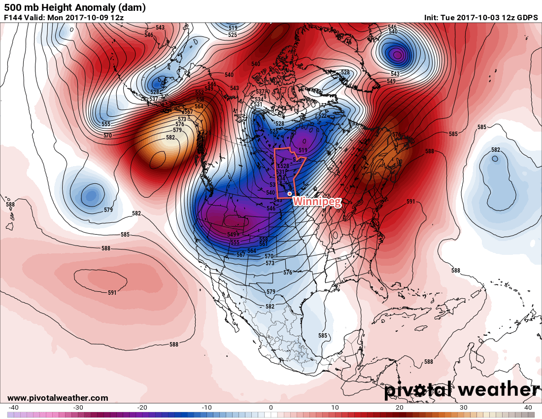
Winnipeg will see mixed to cloudy skies over the coming days as near-seasonal temperatures return to the region. The milder weather will continue until the end of the week, brought to an end by a low pressure system moving through that will usher Arctic air back into the southern Prairies.

Today will bring more cloud to Winnipeg as warmer temperatures move into the region. Highs will climb to around the freezing mark today as south-southeasterly winds pick up to 20 km/h. A few sunny breaks may show up later in the day, however southeasterly winds tend to keep the low cloud stuck in the Valley until a westerly component can develop, so we may see the cloud stick around all day. Winnipeg should see variable cloudiness overnight with winds continuing out of the south near 20 km/h. Temperatures will dip to a low near -3°C.

On Tuesday, a low pressure system will cross through the province, bringing with it variable cloudiness and winds that gradually diminish while shifting more westerly. No rain or snow is expected for Winnipeg and temperatures will climb to a high near +1°C. More cloud will move into the Red River Valley on Tuesday night as winds shift northwesterly behind a cold front and winds pick up to around 30 km/h. Temperatures will dip down to a low near -7°C.

RDPS Forecast 850mb Temperatures valid 12Z Tuesday November 14 to 00Z Wednesday November 15, 2017
The forecast 850mb temperatures show the cooler air pushing southwards behind the cold front as the day progresses

Wednesday will bring cooler temperatures to Winnipeg alongside cloudy skies. Highs will climb back to just around -5°C as northerly winds gradually taper off through the day. There will be a slight chance of flurries, but it looks like there’s no significant chance of accumulating snow. Winds will continue to taper off on Wednesday night as a ridge of high pressure moves into the province, sending temperatures down to lows around -9 or -10°C.

Long Range Outlook

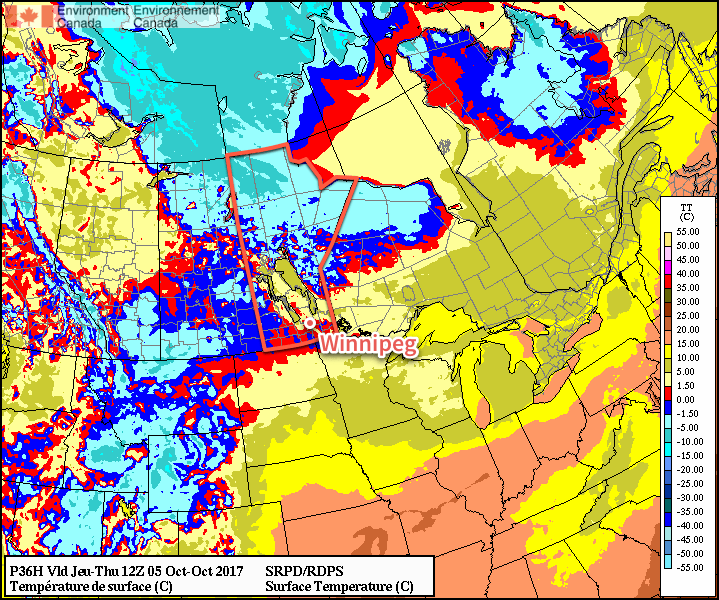
Temperatures will climb back towards seasonal values for Thursday and Friday as another low pressure system begins working it’s way into the western Prairies. Thursday night into Friday looks to bring the chance of some snow as the low passes, then much cooler weather will move back into the province once again, sending highs back down to the -8 to -10°C range with overnight lows dipping back into the mid-minus teens.

Winnipeg’s seasonal daytime high is currently -1°C while the seasonal overnight low is -9°C.

Sunny Skies, Cooler Temperatures, Build Into The Red River Valley

After several days of cloudier conditions, Winnipeg and the Red River Valley will see the sun return for the second half of the week.

The low pressure system that brought a few showers to Winnipeg over the past couple days — although more notably a major winter storm to the southwestern Prairies — is finally making its way out of the region. The upper-level support will finish moving out of the province this morning with mostly cloudy skies giving way to afternoon clearing. Temperatures will climb to a high near 13°C this afternoon with winds picking up out of the southwest to around 30 km/h.

Temperatures will be quite cool tonight as a shot of Arctic air moves through the region. Under clear skies and diminishing winds, overnight lows will dip down to around the +1°C mark in Winnipeg, however that’s for most of the urban areas. At the edges of the city, as well as into the Red River Valley, overnight lows may dip down to the 0 to -2°C range. There will be a risk of frost throughout the region, including Winnipeg.

RDPS Forecast 2m Temperature valid 12Z Thursday October 5, 2017
The Red River Valley will see a risk of frost early Thursday morning as temperatures dip near or below the freezing mark.

Thursday will bring mainly sunny skies to Winnipeg with light winds as a ridge of high pressure slumps through the southern Prairies. Temperatures will be near seasonal with highs climbing to around 13°C again in Winnipeg and overnight lows dipping back down to around the +3°C mark.

Friday will also bring sunny skies to the region with a light southerly wind developing in response to a low pressure system building into the far northern Prairies. Daytime highs will climb up to around 16°C as slightly warmer air pushes northwards, and overnight lows will follow suit dropping to only around 6°C.

Long Range

Conditions look fairly dry for the next while, although a more significant pattern change will move in for early next week. Temperatures look to climb into the upper teens on Saturday with breezy southerly winds, with a cold front then passing through on Saturday evening. At this point, the passage of the front looks dry, and will be followed by a second cold front moving through the region on Sunday night.

GDPS Forecast 500mb Height Anomaly valid 12Z Monday October 9, 2017
A large upper-level trough (shown in blues and purples) will develop over the Prairies early next week, bringing below-seasonal temperatures to the Prairies.

That will leave the Prairies underneath a large upper-trough for Thanksgiving Monday. Temperatures will be below normal with highs just in the upper single digits under cloudy skies with a breezy northwesterly wind and a chance of showers. The road to recovery will be slow, with temperatures gradually rebounding towards seasonal through the remainder of the week.

The Sun Makes A Return

After a streak of cloudy and wet weather which brought the most significant multi-day rainfall totals of 2017 to Winnipeg, the sun is finally set to return. Winnipeg will enjoy several relatively sunny days ahead with temperatures rebounding back towards seasonal values.

After seeing 65.1 mm of rain in the past 10 days, Winnipeg is poised to enjoy a few days to finish drying out1 as fairly benign weather returns to the region. Today will be quite a pleasant day; skies will start off sunny this morning and become more mixed in the afternoon with temperatures climbing to an above-seasonal high near 18°C. Winds will be light until a weak cold front passes through this afternoon, after which they’ll switch to the northwest at around 20-30 km/h for a few hours before diminishing near sunset. Skies will remain partly cloudy to mixed overnight with temperatures dipping to a low near 7°C.

RDPS 2m Temperature Forecast valid 21Z Wednesday September 27, 2017
Temperatures will climb into the upper teens this afternoon across southern Manitoba

Thursday’s main driver for the weather will be a large ridge of high pressure building southwards out of the Arctic. As it pushes towards the southern Manitoba, it will keep winds out of the north at 20-30 km/h with slightly cooler temperatures in place as highs climb to a seasonal 16°C. Skies will remain partly cloudy much of the day. Thursday night will be a cool one as the high pressure centre moves across Southern Manitoba. Temperatures will dip to a low near 2°C with patchy frost an outside chance, but it looks relatively likely (for now) that extensive fog development may occur through the night, which would likely keep lows above the freezing mark. That said, it’ll certainly be cool, so if you have temperature-sensitive plans, probably best to take care of them before Thursday night.

GDPS 2m Temperature Forecast valid 12Z Friday September 29, 2017
The GDPS suggests a patchy freeze will be possible on Friday morning

Friday will bring mainly sunny skies to Winnipeg & the Red River Valley, outside of any fog that may be in the region in the morning. As the high pressure system moves off to the southeast, it will bring southerly winds at around 10-20 km/h as temperatures climb to a high near 16°C again. Temperatures will dip to a low near 8°C on Friday night with winds increasing out of the south to 20-30 km/h.

Long Range

Warmer, but windy, weather will move into the Red River Valley on Saturday with daytime highs climbing towards the 20°C mark as an upper ridge pushes into the eastern Prairies. Conditions begin turning on Sunday as another significant low pressure system moves towards the region. During the day on Sunday will likely be mild, although cloudy, with breezy southeasterly winds. At some point, there will be a more organized chance for rain; likely on Sunday night into Monday morning, but it could easily shift by 12 hours between now and then.

The work week will start off with seasonal temperatures and some lingering unsettled weather until things clear up mid-week again.

Winnipeg’s seasonal daytime high is currently 15°C while the seasonal overnight low is 4°C.

  1. And perhaps letting the grass grow long enough to need to be cut again…

More Scorching Summer Temperatures Ahead

Daytime highs will head back into the 30’s early this week as a low tracking across the northern Prairies spreads well above seasonal temperatures eastwards.

In the wake of a cold front that moved through yesterday evening, today will bring temperatures cooler than Sunday but still well above-seasonal. A weak ridge of high pressure will keep skies clear with winds out of the west at 20-30 km/h as temperatures climb to a high near 26°C. With dew points falling to just 1-2°C, it will also be bone dry out there. Expect a low near 16°C tonight.

A low pressure system tracking across the northern Prairies on Monday night will begin drawing a very warm air mass eastwards out of Alberta and across the Prairies. This warmer air will arrive in Winnipeg on Tuesday with a southwesterly winds of 20-30 km/h pushing temperatures up into the low 30’s. Skies will be cloud-free as well, making for a scorcher of a day. The winds will ease in the afternoon as a weak low pressure system tracks across the valley, and then pick up out of the northeast to around 15 km/h in the evening. Temperatures will dip to a low near 15°C under clear skies.

RDPS 2m Temperature Forecast valid 21Z Tuesday September 12, 2017
Temperatures will climb into the low 30’s across southern Manitoba on Tuesday.

Lastly, Wednesday will bring another day with highs warmer than seasonal, but it may be the last for quite a while. Temperatures should climb to around 25°C with some increasing cloud late in the day. Overnight there will be a decent chance for showers or thunderstorms across much of southern Manitoba as temperatures head down to a low near 14°C.

Long Range

A fairly substantial pattern change will occur for the second half of the week as a deep trough develops over the Rocky Mountains and brings a south to south-westerly flow aloft to the region. This will result in numerous systems moving through in the second half of the week, each capable of bringing a round of rain and/or thunderstorms. Some areas of Manitoba may see the most rain they’ve seen all summer through the second half of this week, including Winnipeg.

GDPS 24hr. QPF Forecast valid 12Z Friday September 15, 2017
Models are producing rather significant amounts of rainfall across the Prairies on Thursday

So wet, unsettled, and cooler weather is on tap for the second half of the work week. At this point it looks like the chances for rain drop off on the weekend, but cloudy(ish) and cool conditions will continue through the weekend with highs in the mid-teens.

Winnipeg’s seasonal daytime high is currently 19°C while the seasonal overnight low is 7C.