Pleasant weather is on tap this week as we see a fair amount of sunshine and above-seasonal temperatures.
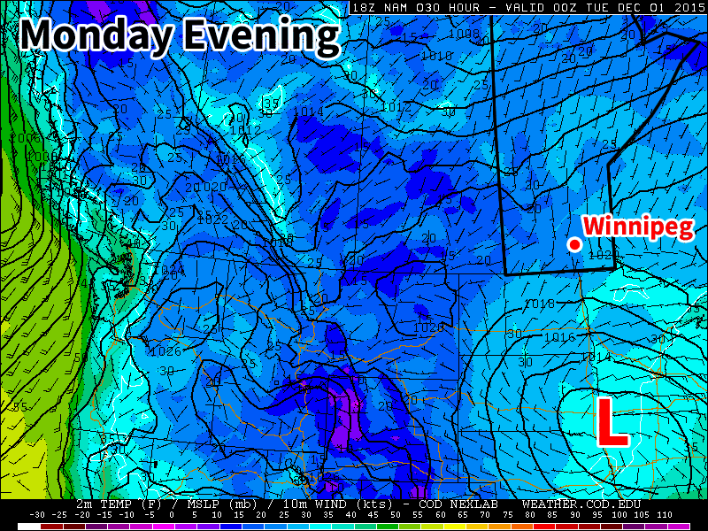
A low pressure system will sit just south of Manitoba early in the week
Monday
Today will see mainly sunny skies and mild temperatures. The daytime high will be just below zero with light southerly winds. A strong low pressure system will be bringing precipitation to portions of the Dakotas and Minnesota early this week, so you’ll want to check the forecast if you’re heading south.
Tuesday
Tuesday will see much the same weather as Monday. Skies are expected to remain mainly sunny, with high temperatures in the mid single digits. If the system to the south pushes a bit further north we may see more cloud cover, but that is not expected to be the case at this point. Winds will be north or north-westerly at 20 km/h.
Wednesday
Wednesday will once again feature mainly sunny skies and mild temperatures. Temperatures will be just below zero, with breezy southerly winds at 20 km/h.
Long Range
The long range forecast continues to strongly suggest above-normal weather for the first half of December. The current weather pattern over North America is very typical of El Nino, with warm conditions across the western half of Canada and an active storm track across the southern US. Expect this pattern to continue as we move further into winter.
With the 2015 Grey Cup taking center stage in Winnipeg on Sunday, one of the most pertinent questions fans heading to the game must be—or should be—wondering is what do you wear to an outdoor event, in Winnipeg, at the end of November? Fortunately, while you’ll still need to bundle up a little bit, the weather will be far more pleasant this year than it has been in many Novembers past.
Heading into the weekend, we’ll see a traditional “transition back towards milder weather” day. This means a day of it feeling quite a bit worse than the basic forecast might imply. Although temperatures will climb to around the –6°C mark today, it will do so with a fairly unpleasant southerly wind blowing down the Red River Valley, likely to around 35–45km/h with gusts up to the 60km/h mark by early this afternoon. This will make it rather unpleasant outside and hide any benefit the warmer temperatures have. It is, however, the unfortunate necessity of bringing warmer weather into the Red River Valley with an Arctic high pressure system to our south.
Saturday will bring seasonal temperatures with highs around –5°C and much lighter winds. The fairly sunny skies will make it an all-around nice day for the end of November. Temperatures will dip to about –10°C overnight.
For Grey Cup Sunday, it looks like temperatures will sit around the seasonal mark of –5 with increasing cloud cover through the day. For kickoff at 5PM, the temperature should be around –4 to –5°C with a light southerly wind of 10–15km/h. The temperature will gradually fall through the remainder of the evening, but should stay within the –5°C to –9°C range. The wind will also taper off as the evening progresses. No snow is expected at this point.
Long Range
For the coming week, conditions look very nice for Southern Manitoba.
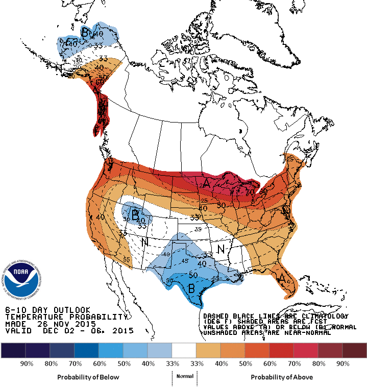
The CPC 6-10 day temperature anomaly forecast, valid for December 5 – 18, 2015
Warmer than seasonal temperatures are expected to spread across much of southern Canada, thanks to a combination of a positive cycle in the Arctic Oscillation (AO) as well as a high over low block that is expected to develop over the west coast of North America.
The positive cycle of the AO means that there is lower than normal pressure over the northern pole, which results, generally speaking, in stronger westerly winds through the higher latitudes. This works to “bottle up” the Arctic air and make it more difficult for it to spill southwards.
The high over low block that is expected to develop over the west cost of North America serves as a powerful “block” in the weather pattern. This feature will remain stationary for several days at a minimum, and will result in benign weather over the Prairies with little precipitation as any significant weather-producing systems are deflected far north or south of our region.
This means that we should expect, in general, seasonal to above seasonal temperatures, little precipitation, and very limited duration to any colder outbreaks should they occur.
Clear skies could mean a daytime high of a degree or two warmer, while temperatures cool off more quickly in the evening. ↩
The first weekend in October is looking like a great one; plenty of sunshine will be seen over the coming few days alongside temperatures 2–3°C above normal for this time of year.
Today and tomorrow’s weather pattern will be dominated by a large ridge of high pressure anchored from northwestern Ontario into northern Quebec, whose presence will be one of the guiding impacts on the track of Hurricane Joquain. Here in Manitoba, dry outflow from the ridge will ensure skies stay clear and a polar jet stream mainly locked in the Arctic will keep the cooler weather well to our north and allow for slightly above-seasonal daytime highs[1] through the weekend.
Here in Winnipeg, we can expect mainly sunny conditions today and tomorrow with daytime highs around 16–17°C. Winds will be out of the south or southeast at 20–30km/h both days, although today will likely be a bit windier than Saturday. Overnight lows both tonight & Saturday night will sit around +3°C.
Sunday will see the pattern begin to break down a bit. The quasi-stationary ridge to our east will begin to shift off towards the east, easing the pressure gradient over the Red River Valley and finally giving us a break from the windy conditions that will have been in place for several days by that point. As things shift to east, however, cloud will begin to spill eastwards into the valley from a low pressure system that has been stalled over the western high plains for several days. This means that Winnipeg will likely see a fairly cloudy day, but daytime highs should be relatively unaffected and remain a couple degrees above normal near 15–16°C.
As we head into Sunday night, the chance for some light shower activity will increase. Very little is expected by way of significant precipitation, although at this point it appears that the slightly unsettled conditions will likely persist through Monday & Tuesday next week.
Above-Normal Temperatures To Persist
Looking ahead into the long range, it appears that the above-normal temperatures are likely to stick around.
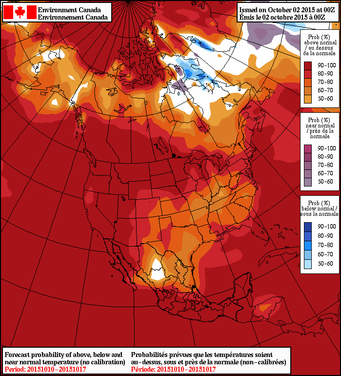
NAEFS 8-14 Day Temperature Anomaly Forecast valid for October 10 – 17, 2015
As the NAEFS 8–14 day outlook here shows, there’s a high probability of above normal temperatures throughout most of Manitoba for the period of October 10–17th, as well as for almost the entirety of the remainder of North America. The NAEFS ensemble has been persistent with this trend for quite a while now, and is what we expect to see in strong El Niño years as it often shunts the polar jet stream to the north and east, allowing warmer air to spill eastwards through the southern Prairies in a more zonal upper-level flow.
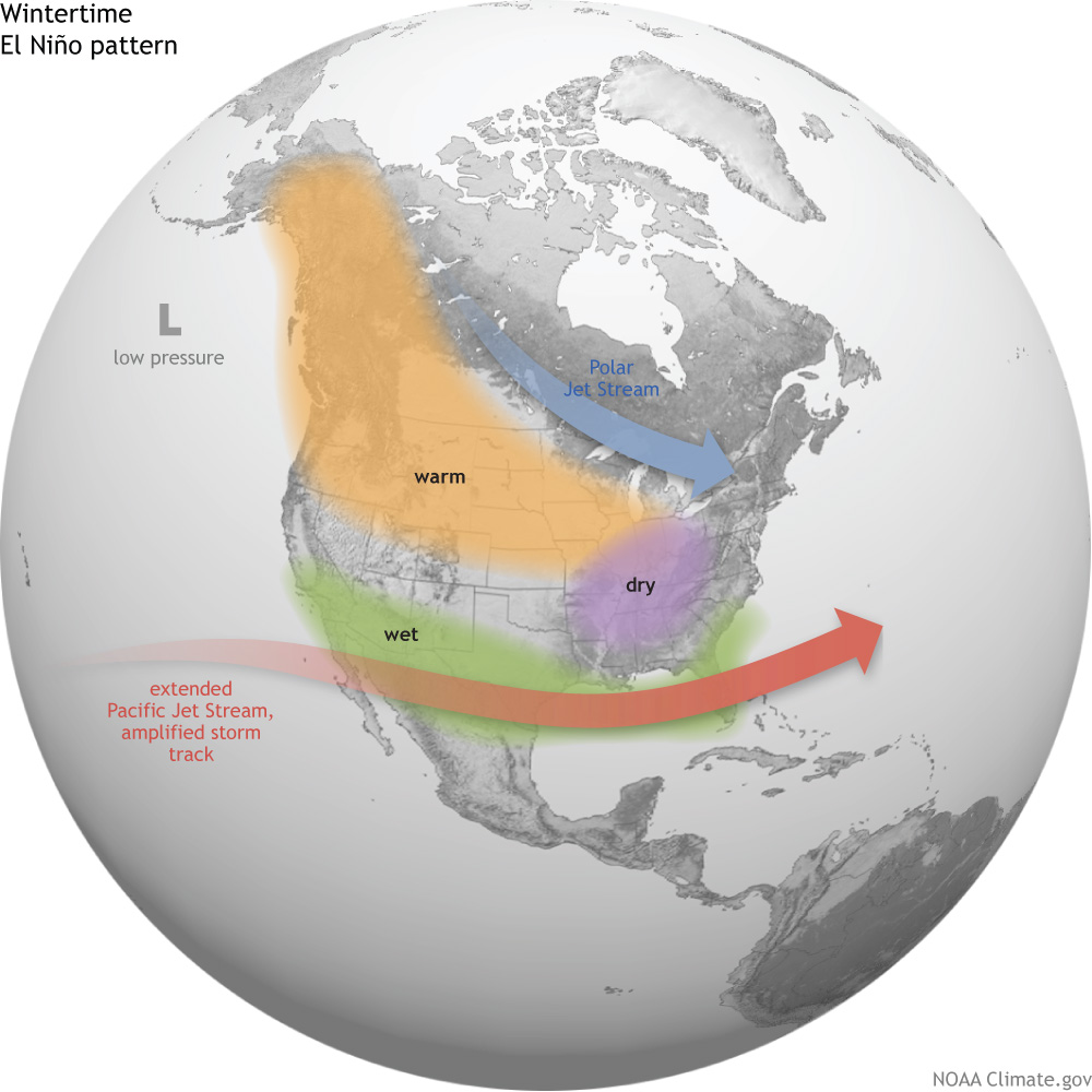
A typical generalized winter weather pattern during strong El Niño events. Credit: NOAA Climate
In El Niño years, persistent low pressure off the west coast of North America tend to produce ridging over the Rockies, drawing warmer air further to the northeast. This ridging shunts the polar jet stream further to the northeast and typically keeps the Arctic blast freezer bottled up a little more.
How strong is this El Nino now? The only real way to answer this is to throw a bunch of numbers at you. Essentially, it’s “pretty strong.”
This year’s El Niño is on track to be one of the strongest on record, which would have a high correlation of generally persistent above-normal temperatures. This doesn’t mean that cold weather isn’t possible this winter; rather it just means that any cold outbreaks will likely be shorter-lived than typical. One of the potential down-sides to this year’s event is that strong El Niño events tend to correlate with cloudier winters in the Red River Valley.
Again, all this is very generalized climate speak; the day-to-day weather can certainly vary significantly and the end result won’t just be a result of the El Niño, but also its interactions with the AO, NAO, and a few other large-scale patterns.
At the most simple level, though, it’s looking like above-normal temperatures will continue for a while yet. Perhaps the most disappointing thing at this point will be watching that “seasonal high” curve get lower and lower.
Enjoy the pleasant fall weekend!
Seasonal daytime highs for this time of year in Winnipeg are around 14°C. ↩
A very cool start today with temperatures in the low single digits will be the last of the near-freezing temperatures we’ll see for a while thanks to a push of warmer air spreading eastwards across the Prairies that will bring summer-like warmth back to the region. The warmer weather will be a welcome sight to many after a week that has seen distinctly fall-like weather and gloomy cloud.
All in all, there isn’t much to talk about on the weather front for the coming days. Today will start off quite cool and see the temperature gradually rise to around 19°C. There may be some fog patches around this morning, but they should burn off fairly quickly after the sun rises. Winds will be fairly light and other than some afternoon clouds bringing mixed skies, there won’t be much going on in the Red River Valley. Temperatures drop to around 10°C under clearing skies tonight.
Tomorrow will see warmer weather begin to work into Southern Manitoba as a flow of warmer air pushes in from the west. Winds out of the south at around 20km/h will mark the arrival of the warmer weather, sending daytime highs to around the 23°C mark across the region under mainly sunny skies. Our overnight low will be considerably warmer tomorrow night at around 13°C.
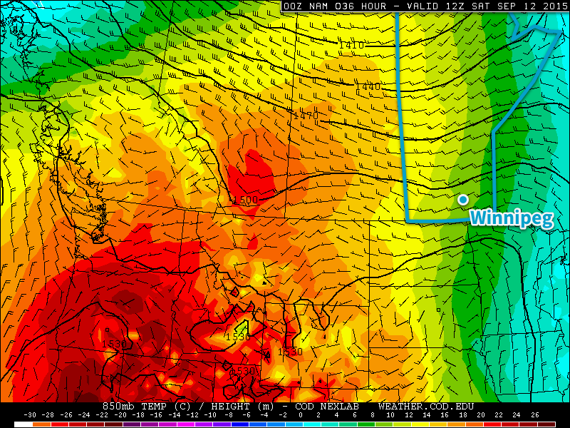
Westerly winds at 850mb – approximately 1.5km above the ground – will be ushering warmer temperatures to Manitoba for the weekend. This image shows warm advection over Manitoba on Saturday morning from the NAM forecast model.
Sunday will the the warmest day of the next few with a high around 26°C under mainly sunny skies. The winds will be a bit more notable, strengthening out of the south to around 30km/h with some gustiness possible on top of that. Overall, though, it will be a very pleasant day. Expect an overnight low just a tad cooler than Saturday at around 11°C.
Cooler Start to Next Week
A weak cool front slumping southwards on Sunday night looks to stall over extreme southern Manitoba on Monday, bringing a bit more cloud cover and cooler daytime highs through the first half of the week. Precipitation looks fairly minimal for areas along and south of the Trans-Canada highway, but a more organized chance for precipitation appears to develop for the northern Parkland & Interlake into Central Manitoba as a low pressure system develops and lifts northeastwards mid-week. This should once again bring warmer weather back to the Red River Valley.