After last week’s high heat and humidity, the much cooler conditions this week will come as a relief to many. However, it might be a little bit too cool, with temperatures only hovering around 20C.
Today will be cool, but fairly pleasant. Temperatures will be near the 20C mark in southern Manitoba under a mixture of sun and cloud. Winds will be light as a surface ridge of high pressure will be in place over southern Manitoba. Portions of western Manitoba may have a slight chance of a shower, but otherwise no precipitation is expected.
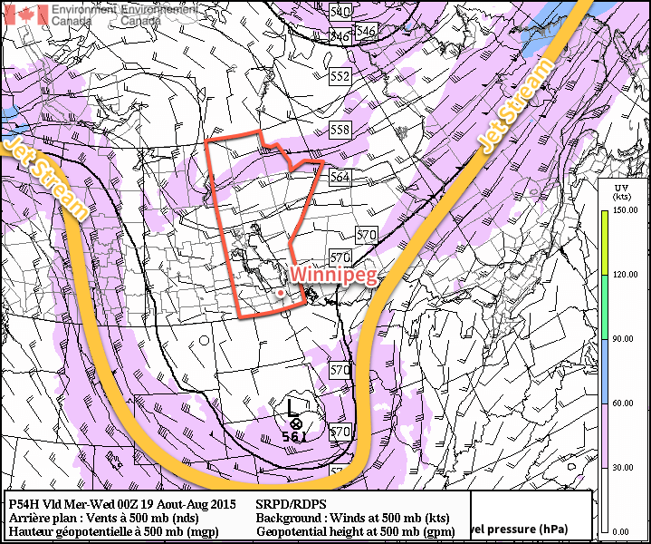
A deep trough over the Central Prairies will deflect the jet stream well to our south, bringing unseasonably cool weather to most of the Prairies.
Tuesday will see little change in conditions from Monday. High temperatures will remain near 20C, with mainly sunny skies. Winds will be from the north-east at 20km/h.
Wednesday will once again be seasonably cool with temperatures in the low twenties. Skies are expected to be a mixture of sun and cloud with breezy winds out of the north.
Long Range
The long range forecast shows generally seasonable to below seasonable temperatures in southern Manitoba over the next week. However, we may see more surges of warm air as move move toward the end of the month.
This week will start out on the cool side with high temperatures in the low twenties.
Monday
Today will be mainly sunny with temperatures in the low twenties. The average high temperature for early August is 26°C, so this will represent cooler than normal weather. The wind will be north-west at 30km/h.
Tuesday
Tuesday will see much the same weather as Monday, with temperatures in the low twenties. Skies should once again be mainly sunny and winds will be light.
Wednesday
Wednesday may feature showers in southern Manitoba as a low pressure system passes through the region. Accumulations look to be fairly small at this point, so it will not be a significant event. Besides the rain, temperatures will remain below seasonal with highs in the low twenties. Winds will be breezy from the south.
After a busy couple weeks across Southern Manitoba, a stretch of mild, fairly quiet weather is ahead thanks to weak upper-level ridging over the eastern Prairies.
Today and tomorrow will both be pleasant days with a few afternoon clouds and highs in 26 or 27°C range. Winds will be a bit breezy out of the west today, but much calmer conditions will be seen on Saturday over the Red River Valley. Expect an overnight low near 10°C tonight and in the mid-teens on Saturday night.
The only chance for precipitation will come late overnight Saturday or Sunday morning as a trough rotates through the Interlake into the Red River Valley. It doesn’t seem like the showers will be too intense or organized, so at this point it seems like there’s just a slight chance of them. Otherwise, Sunday will be a fairly pleasant day with a high in the mid-20’s and winds picking up out of the northwest through the day to around 30km/h.
The RDPS is forecasting temperatures in the mid-to-upper 20’s over Southern Manitoba for Saturday afternoon.
Early next week looks to start off a little bit cool with highs only in the low-to-mid 20’s. At this point, it looks like the next chance for any organized precipitation will hold off until the middle of next week!
After a stretch of summer weather last week that saw daytime highs climbing into the mid-to-upper 20’s, cooler weather has moved into Southern Manitoba behind the weekend’s cold fronts that will start the week off with cooler weather. Temperatures will rebound quickly through what will be a dry & quiet start to the week before things turn more unsettled through the week’s second half.
Today will be the coolest day of the next few with temperatures climbing to just 17 or 18°C as the main axis of cold air behind the weekend’s cold fronts moves across Southern Manitoba. There will be a bit of morning drizzle, but then things should scatter out nicely and Winnipeg will be left with partly cloudy skies through much of the remainder of the day. Winds will be out of the north at around 20 km/h. The clouds will clear out tonight and much of the Red River Valley will see a low near 9°C with light winds.
Tomorrow will bring warmer air to the region; daytime highs will be around 5°C warmer than today at the 22–23°C mark. Winds will be light. The day will start sunny, but by the afternoon cloud associated with a weather system moving through North Dakota will spill across the Red River Valley bringing variable cloudiness; in the southern valley it will be overcast through much of the afternoon while further north in Winnipeg it will be a little more variable and a bit later in arriving. Skies will clear overnight as the temperature drops to around 12°C.
A warm front moving through on Wednesday morning will bring warmer weather back to Winnipeg.
Wednesday will see warm weather return with daytime highs climbing back to the mid–20’s with just a few clouds. Winds will continue to be fairly light, making for a very pleasant day. We’ll see some cloudiness on Wednesday night with a chance of showers. The temperature will drop just below 10°C or so.
Unsettled Second Half of the Week
Cooler, more unsettled weather will move into the Red River Valley for the second half of the week. Temperatures will drop back into the high teens or low 20’s with an increasing chance of shower activity towards the end of the week. There’s still a fair amount of uncertainty in location, but in general it looks like Thursday will see the shower activity west of the Red River Valley and see it push eastwards for Friday into the weekend. Like this past weekend, it likely won’t be a rainy weekend, but rather one with some chances for periods of wet weather.