Cloudy skies, mist/fog, drizzle, and mild temperatures will continue for a couple more days in the Winnipeg area. The weather will finally change across southern Manitoba on Wednesday night as a Colorado Low begins to spread waves of precipitation into the province.


The next couple days in Winnipeg will bring more of what the city has seen lately: plenty of cloud, mist and fog patches, and occasional drizzle. A ridge of high pressure moving across the Red River Valley will keep things stagnant with light northerly winds. The trend of temperatures well above normal will continue with highs a couple degrees above freezing and lows right near the freezing point.
Then, the most notable weather system in weeks will begin to impact the region on Wednesday night. As I mentioned in Thursday’s post, long-range models were developing a Colorado Low-like system and pushing it quickly eastwards. I mentioned that I wouldn’t be surprised to see this system pull further west as it approached and…that’s what has happened with the forecast models over the past few days.
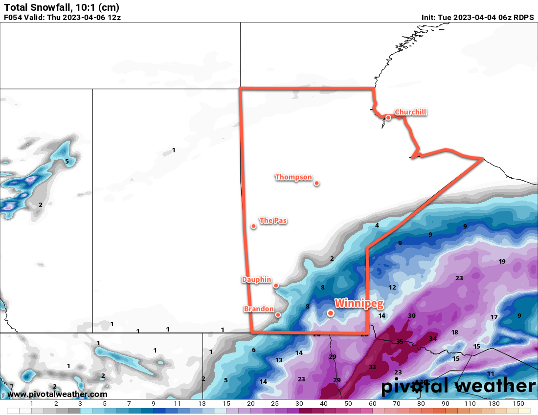
A Colorado Low will eject northeastwards on Wednesday, reaching South Dakota by Thursday morning and then into Minnesota by Thursday evening. As it draws closer to Manitoba, it will begin to spread waves of precipitation into the province. The first couple waves, arriving Wednesday night and Thursday morning could bring a wintery mix of snow, rain, and freezing rain to the Red River Valley. As those move off to the northwest, the region will see a break with cloudy skies and a chance of drizzle.
By later Thursday, northerly winds will strengthen across the region and begin to draw cooler air into the region. More snow will be possible Thursday evening through much of Friday before it finally tapers off.
There is a wide range of snowfall accumulations possible with this system, and at this point there is significant uncertainty as to where the axis of heaviest snow will set up in the province. In general, many areas of the province will receive 5 to 10 cm of fresh snow, with 10 to 20 cm possible in the swath of highest accumulation. Amounts could creep even higher on the northern slopes of the Turtle and Riding Mountains where northerly winds enhance the snowfall along the terrain.
With the notable uncertainty that remains with how this system will set up over the province, I recommend you check the updated forecasts on ECCC’s weather website over the coming days.
Daytime highs in Winnipeg will fall into the -5 to 0 °C range by the end of the week with overnight lows in the -20 to -10 °C range depending on how much clearing is able to move into the region.
Long Range Outlook
The weekend will bring cooler — but still above normal — temperatures to the region. Daytime highs will dip to around -5 °C with lows dependent on how cloudy the nights stay. With clearing, lows could drop into the -20 to -15 °C range, but if it stays cloudier then lows could hover near -10 °C.
Hopefully the region will see a bit of sun this weekend, but there’s a chance things do stay on the cloudier side.
Next week will continue the trend with daytime highs near -5 °C and overnight lows in the -10 to -20 °C range as light westerly winds develop over the region.
Today’s seasonal daytime high in Winnipeg is -10 °C while the seasonal overnight low is -21 °C.