Seasonal Spring Weekend Ahead

After Wednesday’s winter reminder, typical spring weather will return to the region for the region. A potential major spring storm looms next week.

RDPS 2m Temperature Forecast valid 21Z Sunday April 10, 2022
Mild spring temperatures are likely across southern Manitoba on Sunday.

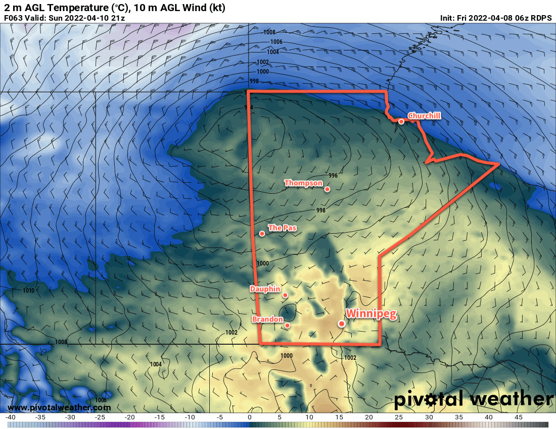
The main weather feature today will be a ridge of high pressure moving over the region. It will bring an end to the strong northerly winds seen the past few days with sunny skies today.

The ridge will shift off to the east on Saturday with a stronger low developing behind it in the western Prairies. This will spread some cloud cover into the region with strengthening southerly winds. As this low crosses the Prairies, it will bring seasonal highs and slightly mild lows to the Winnipeg area.

On Sunday, cloudy skies will likely give way to some late-day showers as a trough of low pressure moves into the region. Sunday has the potential to produce slightly speedier snow melt as warmer weather arrives dew point temperatures climb above freezing through the day. The Winnipeg area could see daytime highs close to 10 °C despite the cloudy skies.

Most of the rain showers will lift out of the Dakotas and push northeastwards across the region. There is some uncertainty with the track right now and Winnipeg may end up missing out on the rain if things shift eastwards slightly.

Long Range Outlook

Monday and Tuesday will bring pleasant spring weather to the region. Through the second half of next week, however, the potential for a significant storm is brewing.

Most weather models have a potent Colorado Low forming on Tuesday that moves into Minnesota by Thursday evening. As it moves northeast, forecasts show large area of moderate to heavy precipitation. The moisture for this would be fed by extensive thunderstorm activity along the system’s frontal wave in the southeast flank. There is still notable uncertainty, but indications are that it’s highly likely southern Manitoba will be impacted by this storm.

ECMWF 24hr. Precipitation Accumulation Forecast valid 06Z Friday April 15, 2022
The ECMWF places Manitoba’s Red River Valley under the heaviest axis of precipitation from this storm system.
GFS 24hr. Precipitation Accumulation Forecast valid 06Z Thursday April 14, 2022
The GFS model produces notable precipitation over the Red River Valley, but over a smaller area and brings the system through earlier and faster.
GDPS 24hr. Precipitation Accumulation Forecast valid 00Z Friday April 14, 2022
The Canadian GDPS model has a solution between the GFS and ECMWF: a bit slower than one with a precipitation envelope that looks closer to the other.

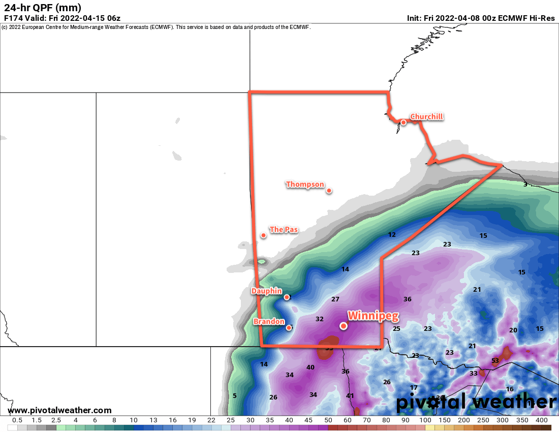
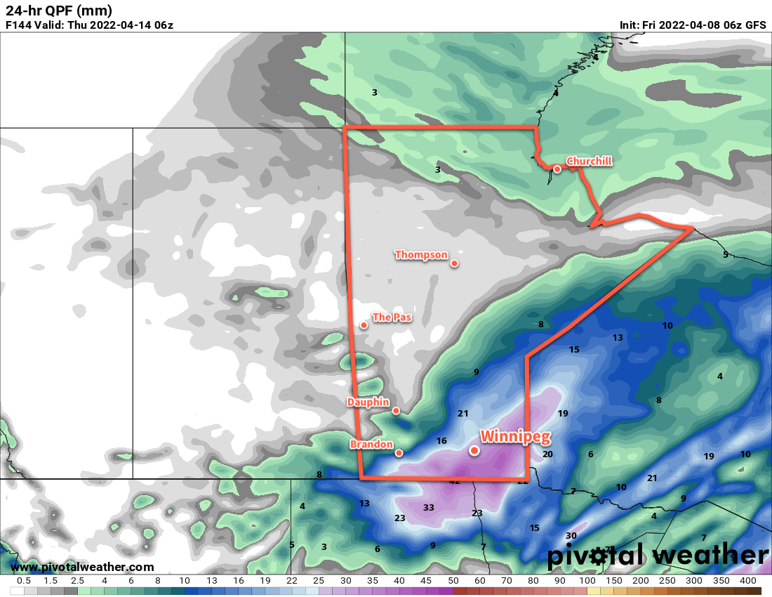
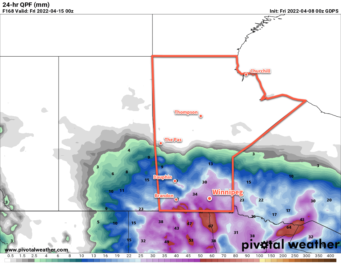
This would likely take the form of an initial wave of snow or mixed precipitation on Wednesday, followed by moderate to heavy snow on Thursday. In this situation, all the precipitation would taper off for Friday. In this outcome, the region would see significant snowfall with at least 10–20 cm of heavy snow likely.

Some other models keep the system a bit weaker and more progressive; in those cases, the region would see significantly less precipitation with impact over a shorter period of time.

Be ready for the chance of a large spring storm in the future; we’ll be keeping an eye on the forecasts as they develop and have more details early next week!

Today’s seasonal daytime high in Winnipeg is 8 °C while the seasonal overnight low is -4 °C.

Major Winter Storm Set to Hit Southern Manitoba, North Dakota

A potent Colorado low will bring the first blast of winter to southern Manitoba in the form of a high-impact storm.

A developing Colorado Low will spread several waves of precipitation across southern Manitoba over the next few days. It all begins later today as light rain moves into the Red River Valley from the west.1 The rain will weaken overnight, but the next wave of precipitation will surge northwards early Thursday. This will fall as rain over SE Manitoba and change to snow across the Red River Valley. For many areas, it likely means a winter mix through the day.

Forecast precipitation amounts are high, with 15 to 25 mm forecast for the region. Any areas that see more of this as snow than rain could end up with a good 10 to 15 cm of wet, heavy snow by the end of the day. In Winnipeg, it looks likely that the city will see a mix of rain and snow through much of the day, changing to snow at night.

Another wave of precipitation will move through on Friday, bringing more rain and snow to the region. Another 15 to 30 mm is possible Thursday night through Friday, bringing storm-total precipitation into the 30 to 50 mm range.

Regardless of what form it takes, a lot more water is on the way for southern Manitoba.

Where exactly the transition from snow to rain occurs will need to be determined as the event itself develops, but we feel this is the most likely outcome. Different areas will see varying amounts of snow and snow accumulation based on where that line sets up. In the hardest hit areas, snowfall in excess of 25 cm may be possible. As mentioned before, the snow will be heavy and wet. Other areas may see upwards of 50 mm of rain. No matter how it falls, a lot more water is on the way for southern Manitoba.

Follow our twitter account for short-form updates as this system develops. If you are travelling in the coming days, know that the weather will be similarly poor across eastern North Dakota and adverse to dangerous driving conditions may develop.

In addition the precipitation, this storm will bring strong northerly winds and cool temperatures.

The cooler air will surge into the region today, sending temperatures falling to +4°C by the end of the afternoon. As the precipitation moves in tonight, temperatures should fall further to around +1°C by Thursday morning. Through the rest of the work week, temperatures will hover within a degree or two of the 0°C mark.

Winds will pick up out of the north into the 30 to 40 km/h range today, then strengthen to 40 gusting 60 km/h on Thursday. On Friday, winds may reach 50 gusting 70 km/h in some areas, especially in the lee of the lakes. In areas where these strong winds can combine with snow, visibilities will be severely restricted and the winds may produce damage add stress above and beyond the heavy loading from the wet snow.

One of the larger areas of uncertainty is on Friday. Forecast models diverge on where exactly the low centre goes, and some are bringing it relatively far west into southeastern Manitoba. If that occurred, it would be likely that Winnipeg, the eastern Red River Valley, and the southeastern corner of the province would be spared from much of the precipitation. We’ll be keeping an eye on things to see how they develop.

Long Range Outlook

A wintery mix of precipitation will likely persist through much of Saturday, tapering off to a chance of showers or flurries on Sunday. Temperatures will remain cool with highs of just 2 or 3°C and lows near +1°C. No significant precipitation is forecast into next week, although temperatures will remain well below seasonal values right into the end of the work week.

Today’s seasonal daytime high in Winnipeg is 12°C while the seasonal overnight low is 1°C.

  1. West of the Red River Valley, it will fall as snow instead.

Mild Start to Week Turns Unpleasant

Winnipeg will enjoy two mild days before what may be a significant winter storm moves into the province.

Winnipeg will enjoy seasonable warmth over the next couple days. An upper level ridge moving across the region will usher in southerly winds and warmer weather. Both today and tomorrow will see highs climb towards 20°C with southerly winds of 20 to 30 km/h. The city should see plenty of sunshine both days and seasonably mild overnight lows.

Seasonably mild temperatures will be in place over southern Manitoba on Tuesday while a sharp cold front pushes towards the region.

Unfortunately, a significant change in the weather is on the way for Wednesday. A potent low pressure system tracking through the Northwest Territories will combine with a deepening long-wave trough to send a cold front surging southeastwards across the Prairies. It will push into southern Manitoba on Wednesday, bringing much cooler temperatures and cloudy skies. Winds will strengthen to 30 gusting 50 km/h out of the north and the entire region will see a chance of showers.

While the Red River Valley may see rain showers on Wednesday, snow will likely push into southwestern Manitoba and the Interlake region.

The precipitation will organize on Wednesday night with heavier bands lifting northeastwards out of the Dakotas. There’s some uncertainty right now, but it’s possible that the rain mixes or changes over to snow sometime Wednesday night.

Long Range Outlook

Before anything else: there is still significant uncertainty with how the weather will develop later this week. With that said, southern Manitoba may see a multi-day winter storm on Thursday through Saturday. A potent Colorado Low will begin lifting northeastwards on Thursday, spreading moderate to heavy precipitation into the region. While this happens, northerly winds will strengthen and sustain a feed of cold Arctic air into the region. As the low reaches Lake of the Woods on Friday, it is forecast to stall out for 24 to 48 hours. This will result in bands of precipitation back into southern Manitoba, gradually changing to snow.

Exactly how much precipitation the region sees and what it falls at is uncertain; there’s a lot of ways this forecast can change between now and then. If this ends up on the snowier side, it could end up being a fairly major snowfall with at least 20 to 30 cm of the white stuff. Persistent rainfall may reduce snowfall amounts in some areas. But more rain isn’t exactly a desirable thing for a region whose rivers are already swollen with excess rainfall over the past month. This system could easily produce another 25 to 50 mm over the region which, if falling as rain, would quickly find its way into the river and aggravate overland flooding issues that exist in areas of the province.

We’ll be keeping an eye on this system as it develops and have more details in our Wednesday morning forecast.

Today’s seasonal daytime high in Winnipeg is 13°C while the seasonal overnight low is +2°C.

Winnipeg Set For A Mild Weekend, But A Big Cool Down Looms on Horizon

The mild weather Winnipeg has seen lately will last for a few more days, but a low pressure system that tracks across the northern United States on Sunday night will usher in a major pattern change which will allow Arctic air to spill southwards across the Prairies, bringing significantly colder temperatures to southern Manitoba.

Warm, unremarkable weather is on tap for Winnipeg today and tomorrow as a slack flow remains over the region with just a few very weak upper-level disturbances moving through. A weak upper-level disturbance moving into the region will bring increasing cloudiness today as temperatures head to a high near +1°C. No precipitation is expected and winds will remain light. Temperatures will dip down to a low near -7°C tonight with the clouds clearing out by Saturday morning.

Winnipeg will see partly cloudy skies on Saturday with temperatures rebounding to a high near 0°C with light southerly winds. Temperatures will then dip to a low near -6°C on Saturday night with increasing cloudiness.

Everything begins to change on Sunday as a low pressure system develops across the northern Plains of the United States. There’s still a fair amount of uncertainty associated with this low; some models want to keep it relatively progressive and move it through South Dakota, while others develop a more potent Colorado Low that lifts northeastwards towards Thunder Bay. Either way, it should bring mainly cloudy skies to the region on Sunday with a chance for snow moving in on Sunday night. Given the significant uncertainty with this system, an update on what to expect will be posted sometime Saturday evening or Sunday morning.

Long Range Outlook

Without question, the biggest aspect of the long-range forecast is the dramatic cool-down that will occur next week.

By Tuesday morning a much cooler air mass is forecast to be in place over the province

As Sunday’s low pushes eastwards, a large upper-level ridge will build over British Columbia, remaining anchored over the Rockies. A large upper-level trough will develop over eastern North America, bolstered by the incoming low pressure system from the Northern Plains.

This pattern will result in a steady northwesterly flow over the Prairies, setting up an Arctic pipeline that will usher much colder air southwards into the Prairies. It appears that by mid-week, daytime highs in Winnipeg may fall into the mid-minus teens. Another way: by the middle of next week, Winnipeg’s daytime highs may fall to what the seasonal overnight lows are for this time of year.

So, enjoy the mild weather while it lasts, by this time next week it will be a whole lot colder than it is now!

Winnipeg’s seasonal daytime high is currently -7°C while the seasonal overnight low is -16°C.