Brutal Cold Builds Into Southern Manitoba

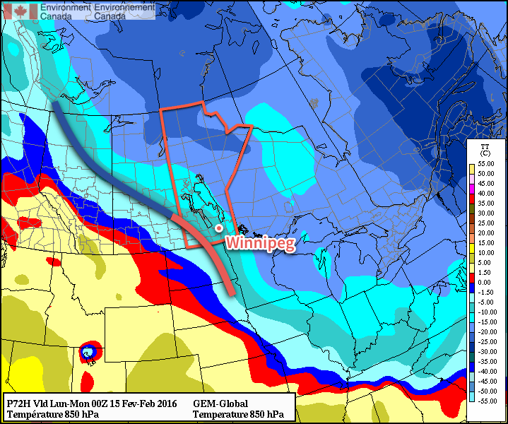
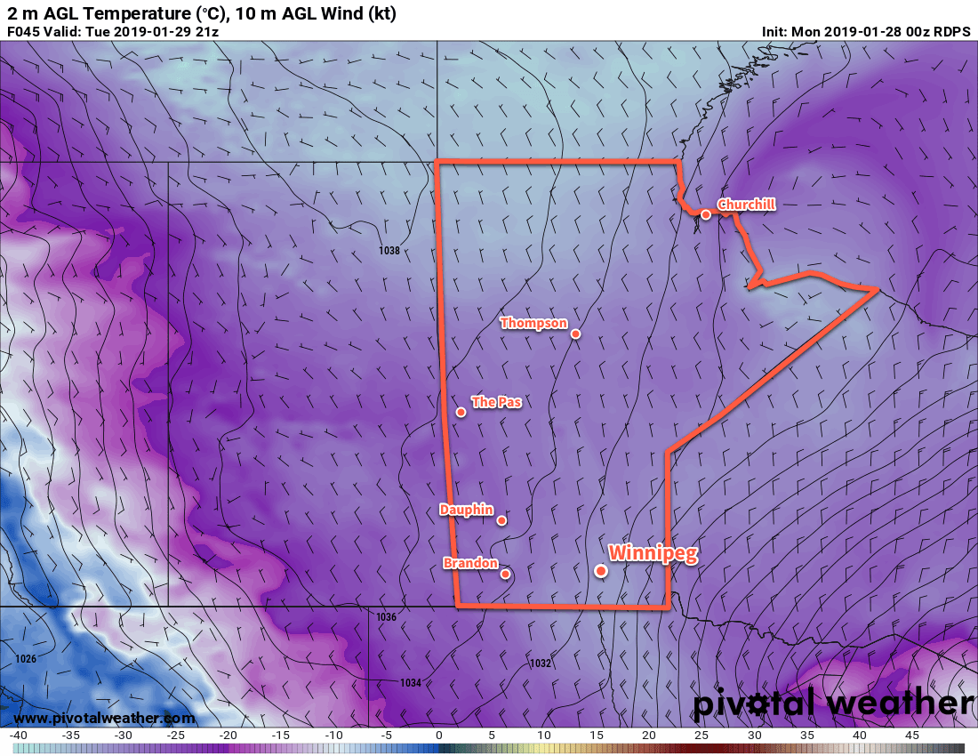
Winnipeg will experience life-threatening temperatures this week as brutally cold Arctic air moves into the region.

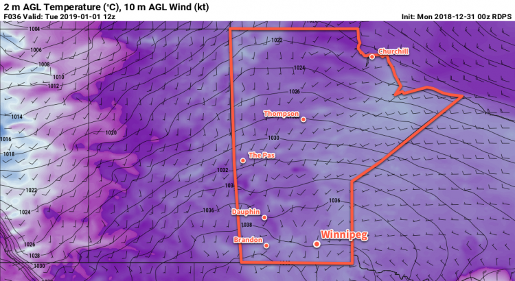
There isn’t a whole lot of setup to this story: in the wake of yesterday’s clipper system that moved through Saskatchewan, a huge surge of Arctic air will spread across the Prairies. Today will be a comparatively mild day with a high near -18°C. Skies will clear out bys late this afternoon, marking the arrival of the bitterly cold air. Temperatures will drop to a low near -35 tonight. Winds of 30 gusting 50 km/h will be in place for Winnipeg today, easing to 20 km/h overnight. That’s a stronger wind than normally seen in Winnipeg when this cold and will produce wind chill values in the -45 to -50 range.

Tuesday and Wednesday will both bring daytime highs near -30°C for Winnipeg. Winds will increase into the 30 to 40 km/h range for Tuesday afternoon, producing wind chill values in the -45 to -50 range. The winds will then gradually diminish on Tuesday night as temperatures drop to a low near -38°C. Wind chill values will likely hover in the -45 to -50 range. Wednesday night will be marginally “warmer” with a low near -35°C.

Temperatures will struggle to climb to -30°C in the Red River Valley on Tuesday.

Needless to say, when daytime highs struggle to reach even -30°C, the cold presents a real threat to those unable to get inside. Consider donating to shelters to help those who are unable to escape the elements. Ensure that your car contains a winter survival kit if you’re travelling on area highways. Having one could mean the difference between inconvenience and serious harm if you end up stranded on the side of the road somewhere for some reason.

Winnipeg may challenge some records in the coming days. While we are unlikely to set record lows unless temperatures really drop on Tuesday night and end up in the -40s, the city may see some new record low maximum temperatures. The record low maximum for January 29th is -32.0°C set in 2004. The record low maximum for January 30th is -30.8°C, also set in 2004.
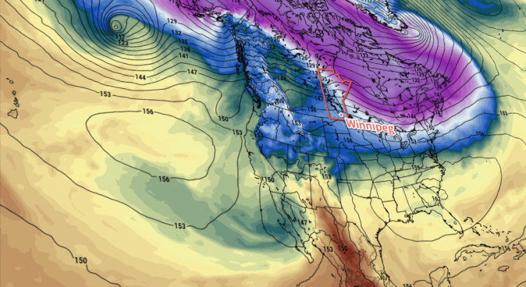
Long Range Outlook

Cloud cover and milder temperatures will begin working into the city through the remainder of the week. The city should see a daytime high in the -25 to -20°C range on Thursday followed by near-seasonal values on Friday. Some snow is possible to round out the work week and start the weekend.

Winnipeg’s seasonal daytime high is currently -12°C while the seasonal overnight low is -22°C.

Coldest Temperatures of the Season Arrive

Winnipeg will start the week with some of the coldest temperatures so far this winter. Fortunately, the cold weather will be short lived with milder Pacific air returning for the second half of the work week.

An Arctic high will bring Winnipeg an outbreak of bitterly cold temperatures to start the week. The city will see well below-normal temperatures today as the high struggles to reach -24°C. Breezy northerly winds of 20 to 30 km/h will be in place this morning, which will combine with the cold temperatures to produce wind chill values in the -40 to -45 range.1 Those northerly winds will persist through much of the day, keeping wind chill values in the -35 to -40 range through much of the day. The wind will ease in the evening as temperature drop to the coldest so far this season. By early Tuesday morning, Winnipeg’s temperature is forecast to drop to about -31°C.

Winnipeg will continue to see sunny skies on Tuesday. Temperatures will warm slightly from Monday with a high near -21°C in Winnipeg. The wind will make things uncomfortable as it picks up out of the south into the 30 to 40 km/h range. This will once again produce wind chill values in the mid-minus thirties. The wind will continue overnight as temperatures will rise to around -17°C with increasing cloud.

Near-seasonal temperatures will return to Winnipeg on Wednesday. With southerly winds near 20 km/h, temperatures will climb to a high near -8°C. Skies will remain mixed with a small chance of some light snow. Temperatures will continue to rise on Wednesday night as the wind shifts westerly. By Thursday morning, the temperature in Winnipeg should sit near -4°C.

Long Range Outlook

The remainder of the work week will bring mild temperatures and a fair amount of cloud cover. The weekend may bring some sun for Saturday, but on Sunday it looks like temperatures will return towards seasonal as a cold front brings clouds and flurries to the region.

Winnipeg’s seasonal daytime high is currently -13°C while the seasonal overnight low is -23°C.

  1. Environment and Climate Change Canada issued an extreme cold warning for this yesterday afternoon.

Massive Warm-Up On The Way

Today will mark a bitterly cold end to the week, but significantly warmer weather is on the way as the jet stream pushes northwards and allows mild Pacific air to spill across the Prairies.

Unfortunately, before we get to the warmer weather, we have to make it through today which will be, generally speaking, miserable.

We’re off to a cold start with an extreme cold warning as temperatures sit below -30°C with wind chill values dipping below -40. Warmer weather will attempt to push into the region today, but cold air will be pumped northwards up the Red River Valley out of the Arctic high that is now to our southeast. This combination will make today particularly uncomfortable as our freezing, but relatively calm, morning turns into a cold and uncomfortably windy afternoon.

Temperatures will climb to a high near -19°C today but winds strengthen midday out of the south to 30-40 km/h, maintaining wind chill values near -30. These strong southerly winds will likely produce areas of poor visibility in blowing snow throughout the rural regions of the Red River Valley.

Winds will taper off tonight as the warm front finally pushes through the region, allowing warmer air to finally push into the Red River Valley.

The 4km NAM picks up on the stronger southerly winds of 30-40 *km/h* expected through the Red River Valley today.

Temperatures will dip just a few degrees to -22°C tonight.

Saturday will be much nicer with winds of 10-20 km/h out of the south-southwest, just a few clouds and a high near -12°C. We’ll see a few clouds overnight as temperatures drop to -15°C or so.

Sunday will be another nice day with mixed skies, winds of 15-25 km/h, and a high near -7°C. Skies will be clear on Sunday night with a low near -13°C.

Long Range

The good news is that even warmer air is on the way next week and it doesn’t look like it’s going to go anywhere any time soon.

There is fairly good agreement across multiple models and agencies that the upcoming pattern change will be prolonged and produce generally above-normal temperatures for the next 2-3 weeks. At the moment, next week looks warm with daytime highs climbing to the freezing mark with little precipitation expected.

Mild Weather Returns for End of Weekend

Bitterly cold temperatures will be in place today as a strong Arctic ridge of high pressure moves through the region. This cold snap will be short-lived as warmer air begins moving into the region through the weekend; by Sunday, milder temperatures will be in place alongside some light snow.

Today will be, temperature-wise, the coldest day of the week as temperatures are held back by the breezy northwesterly winds of an advancing Arctic air mass. Temperatures will recover only a little bit as they struggle to climb to an afternoon high near -21°C before quickly beginning to drop as the sun goes down this evening.

Environment Canada's extreme cold warning issued Thursday afternoon.
Environment Canada’s extreme cold warning issued Thursday afternoon.

Temperatures will plummet to the -30°C mark by Saturday morning as winds gradually diminish. Wind chills this morning as well as tonight will likely be flirting closely with the -40 mark. Environment Canada has issued an extreme cold warning for much of the province because of that.

Saturday may end up feeling like a colder day than Friday; while warmer temperatures may begin to work into the region, they’ll be accompanied by those famous winter southerlies that result in a fairly miserable transition day to warmer weather. While temperatures will rise towards -15°C by the end of the day, southerly winds will strengthen to around 40km/h making it feel significantly colder than it actually is. As a warm front begins moving into Manitoba later in the day, it will spread cloud cover into the Red River Valley and by mid-evening, it seems likely that skies will be mixed to cloudy with a chance of flurries. It will stay fairly windy through the night as temperatures continue to rise to around -12°C by Sunday morning.

GDPS 850mb temperature forecast valid Sunday evening
A frontal wave will pass through Manitoba on Sunday brininging warmer weather and light snow.

Sunday will be significantly more pleasant as mild weather continues to move into the region. Temperatures will climb to near -6°C on Sunday afternoon with light winds and a good chance of light snow. No significant accumulations are expected with Sunday’s disturbance, although 1-2cm of snow could pile up locally. Temperatures will fall to just -9 or -10°C on Sunday night under cloudy skies.

Long Range: Generally Mild

Looking ahead into next week, it looks like Southern Manitoba is transitioning into a generally above-normal temperature pattern.

CPC 6-10 Day Temperature Anomaly Forecast
The CPC is calling for above normal temperatures in the 6-10 day timeframe.

Milder Pacific air will be building into the province through much of next week. The start of next week will see a bit more variability in temperatures, with some days above normal and some below, but by the second half of the week there seems to be a fair amount of confidence of temperatures switching to a more persistent above-normal pattern. Current guidance places daytime highs near -5°C by the end of next week into the week after.

Through this period, no significant precipitation events are expected.

The normal daytime high for Winnipeg is currently -9°C and the normal overnight low is -19°C.