Elsewhere in Weather News: April 27th, 2013

Fairly Calm Week

It has been relatively quiet weather-wise across the globe this week with no significant events affecting heavily populated areas. However, there were still some extreme weather events that took place, although more localized.

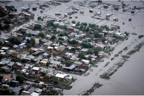
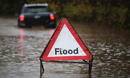
This past Thursday, a cold front pushing south across Hong Kong and parts of south-east China dropped excessive amounts of rainfall, triggering flood concerns. The front had significant warm and moist air to work with as it slowly moved south towards the South China Sea. Several reports came in from south-eastern China showing 50mm of rain in a 24 hour period, concerning residents of increased flood risk this weekend and into next week thanks to another low pressure through making its way into the region.

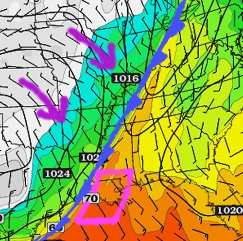
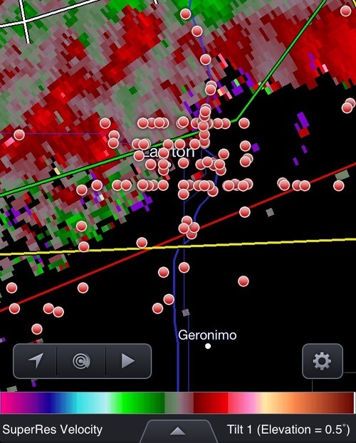
In other news, isolated severe storms pushed through the state of Louisiana Wednesday. The long cold front extended from Southern Ontario all the way down to Louisiana; where dynamics were most favorable for severe storms midday Wednesday. A weak tornado even touched down in Keeling, a suburb of New Orleans, causing power outages and downing trees. After the storms moved through, 32,000 people in the area were left without power, but it has since been restored. There is a chance for more severe weather in the same area on Sunday and severe weather in the Plains region early next week. Following those events, there isn’t any indication of severe weather until at least next weekend as moisture gets flushed out. What comes after that remains to be seen as there is much uncertainty between weather models.

Dewpoints

Surface dewpoints (in Fahrenheit) Wednesday morning. Cold front is clearly visible and the circled area ahead of the front in Louisiana had the highest tornado potential. (Source: Twisterdata)

Elsewhere in Weather News: April 20th, 2013

Major Trough Moves through US

A trough of low pressure moving across a large swath of continental United States this week has been the cause for severe flash flooding, much wind damage, and a few tornadoes including Canada’s first of the year.

The first severe weather day occurred on Wednesday, April 17th, when a moderate risk was issued by the SPC for most of Oklahoma, parts of south-west Kansas and Missouri. Over 150 chasers (reporting) were scattered throughout Oklahoma, and at one time over 50 chasers could be seen on the same supercell! Severe thunderstorms fired along the warm front and further along the dryline that extended into Texas in early afternoon. The storms that had the largest tornado potential went up in south-western Oklahoma and moved towards the north-east. These storms along the warm front trailed each other and produced flash flooding in some localities. Also to note is that a few cities such as Lawton, OK who were lying along the warm front saw not one supercell that day, but three within four hours. One of these also dropped a tornado which caused some damage to an industrial area on the outskirts of the town.

Chasers

Incredible chaser convergence (red dots) in Lawton ahead of a supercell. Just about every single street in Lawton had a chaser on it! (Source: Spotter Network/RadarScope)

On Thursday and Friday the trough continued its push eastward, but it became less of a tornado threat and more of a severe wind and hail event. At one time, thunderstorms stretching from Ontario all the way down to Texas could be seen. A few states such as Illinois, Iowa, Alabama, and Missouri saw extremely heavy rain in a short period of time which was cause for flash flooding concerns. Air rescues took place in Oxford, Alabama to save stranded motorists caught in their partly submerged cars. Canada’s first tornado of 2013 was also recorded on Thursday, rated as an EF 1 it touched down near Melanchton, Ontario.

Tornado damage

Damage of a barn in Southern Ontario from the EF 1 tornado. (Source: Steve Murphy EMC via Caledon Enterprise)

The cooler weather is not expected to last this weekend as return flow sets up and southerly winds kick in for most of the Plains and Midwest. Later next week it appears as though yet another high pressure will slide down the Rockies, in turn bringing more unseasonably cold air to the Central United States.

Elsewhere in Weather News: April 6th, 2013

Historic Flooding in Argentina

Major cleanup efforts are underway in Argentina this weekend after major flooding occurred in the city of La Plata (pop. 250,000), just east of Buenos Aires. In some areas of La Plata, over 150mm fell in less than a 24 hour period causing for some flash flooding when the city’s sewers simply could not keep up. The reason for so much rain over one area can be attributed to a nearly stationary low pressure system over Argentina, south-west of Buenos Aires. Moist air from the South Atlantic was drawn in and the near stationary thunderstorms stayed over La Plata for over ten hours, beginning April 1st, lasting through April 2nd.

La Plata flooding

Aerial image of one of La Plata’s hardest hit areas. (Source: Reuters)

Flooding caused whole neighbourhoods to be submerged and people had to escape from their houses through the roof as floodwaters rose up to three feet. At one point, three million people were without power across Argentina because of the heavy rains. Some 2,200 residents of La Plata had to be evacuated. Unfortunately, 54 people have died from this event and there are still around 20 people missing. The property damage is extensive and is still being calculated but is likely to be in the hundreds of millions.

Elsewhere around the world:

  • There has also been severe flooding in Eastern China and Taiwan due a series of low pressure systems that brought heavy rain to an already saturated soil base.

  • This week will likely bring another multi-day, severe weather outbreak in the southern half of the US; from the Southern Plains into Dixie Alley, as a large trough digs across the region and warm, moist air from the Gulf of Mexico clashes with it.

Elsewhere in Weather News: November 24th, 2012

Severe Flooding Strikes England

Intense flooding has hit parts of the UK these past couple of days and more is to come this weekend. A strong low pressure system approaching England from the south-west has brought with it plenty of moisture which has already flooded out 300 properties and caused one death.

Flooding

Roads flooded out quickly in South-West England as torrential rains fell this past week, more is to come. (Source: The Guardian)

South-West England is most at risk. Areas including Exeter and Bristol were included in the ‘amber risk’ (second highest level) which was issued by the Met Office as more localised flooding was likely to occur. By Saturday afternoon, it will not be uncommon to see rainfall reports exceeding 50mm in South-West England. This, coupled with ground already saturated to its maximum, will cause flash flood conditions where streams could easily overflow in a matter of hours. In total, 70 flood warnings and 150 flood alerts had already been put in place as of Friday. High winds add to the storm’s grave concern, as gusts of 90km/h are not out of the question for Saturday’s event.

Surface analysis

Surface analysis of the UK on Saturday at 7pm. (Source: Met Office)

Areas of South-West England typically see an average of 16 rainy days and 70mm of rainfall in November. Therefore it’s not unusual to see rain in that area during the month of November but the expected amount to be seen this weekend is on the high end of the spectrum. The highest 24-hour rainfall ever recorded in South-West England (Martinstown) was in 1955 where 279mm, over half of Winnipeg’s annual precipitation, fell!