Elsewhere in Weather News: September 15th, 2012

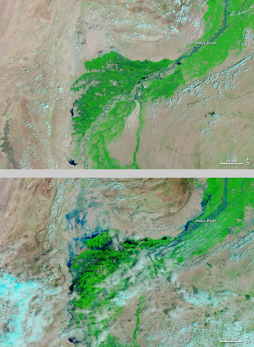
Pakistan Monsoon Flooding

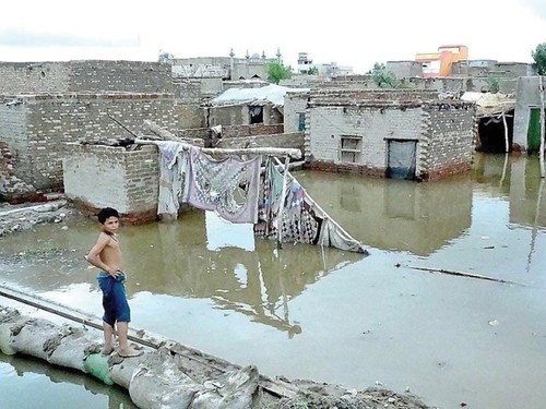
Severe flooding occurred in Pakistan early this past week, after monsoon rains moved into the region and dropped large amounts of rain. Even though Pakistani officials had issued a flood warning for many low-lying areas such as Punjab and Sindh, many residents decided to stay put to battle out the floods in their villages.

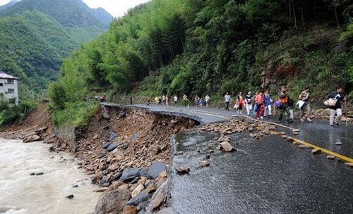
As numerous canals and rivers overflowed their banks because of the heavy monsoon rains, many low-lying areas such as farmland, villages and roads were inundated with water. The highest rainfall report that could be found was in Rahimyar Khan where 193mm fell in 24 hours between Sunday the 9th and Monday the 10th.

Pakistan flooding

Two satellite images (visible/IR enhanced) showing the difference between no flooding and severe flooding in Pakistan. Notice the dark blues along the Indus River. (Source: NASA)

About 1,500 houses were destroyed in the process and over 100 people perished with waters rising quickly and houses collapsing from waters. The country’s army was deployed to execute search and rescue missions in the hardest hit areas, and to try to fill in the areas where water broke through the canals.

Flooding

Picture showing the flooded houses in the town of Larkana located in the region of Sindh. (Source: APP)

Estimated total losses look to be in the neighbourhood of a couple million, though it’s difficult to assess at this time as authorities are still tallying up the damages and looking for survivors. When the floodwaters recede, most likely in a couple days, the final tally from the total economic loss and death toll should be more accurate. This monsoon season does not compare to 2010 though, where numerous severe flooding events occurred and residents described that year as “the worst in living memory”. In 2010 the total structure damage that accounted for four billion in damages and the floods had a significant impact on 20 million people with around 2,000 deaths.

The monsoon rains have since moved away a couple days ago from the region of concern and crews will be able to clean up, repair villages and search for more survivors this weekend.

Elsewhere in Weather News: September 1st, 2012

Tropical Depression Isaac: Update

What was once dubbed Hurricane Isaac when it made landfall as a category one hurricane, is now considered a ‘tropical depression’. Isaac continues to pose a threat a week after it made landfall but it has weakened significantly, and will continue to do so, as it penetrates further into the southern half of Continental United States. Although this hurricane was “only” rated a category one when it made landfall, comprising of maximum sustained winds of 135km/h at peak intensity, you would have not guessed the incredible amounts of rain it brought into Louisiana and surrounding Gulf States. Here are a couple of the most impressive rainfall totals recorded throughout the whole event:

-In Gretna, LA, the National Hurricane Center (NHC) unofficially reported 466mm of rainfall.
-In New Orleans, LA, 510mm of rainfall was reported, breaking New Orleans’ old daily rainfall record by 48mm (a record thsat was set by Hurricane Katrina).
-In Kiln, MS (west of Gulfport) 433mm of rainfall was reported.

Not only did Hurricane Isaac bring with it enormous amounts of rain, the storm surge that accompanied it was quite severe. Wind-driven storm surge is mostly caused by the severe winds accompanying a hurricane. These winds push ocean waters towards land similar to a wave but larger in size (in this case with south winds) and in turn, ocean levels are higher than the normal tide. This phenomena makes for serious flooding along the Gulf Coast since the terrain along the Gulf of Mexico is not mountainuous – it is more of a gradual slope. When ocean water then rises, it is easy for it to move inland quickly.

Isaac storm surge

Hurricane Isaac’s wind direction depicted with arrows. Blue boxes along the shoreline show areas where winds were favorable for storm surge. Green arrows (north winds) is where storm surge was less favorable because of the wind direction. Picture was taken just before landfall on the night of August 28th. (Source: NOAA)

In Louisiana, two people lost their lives in the Plaquemines Parish, one of the hardest hit parishes, as the tide rolled in and consumed their house. This now brings the Hurricane Isaac death toll in the United States to four, with damages listed in the hundreds of millions. In Louisiana and Mississippi, power was out to over a million people and it was estimated that 75% of New Orleans was out of power when the eye wall passed closest to the city. For a storm being of weak category one, it did an extensive amount of damage. This was in part caused by it’s broad area of precipitation, large area extending out from the eye of tropical storm force winds, extremely slow movement, and storm surge levels you would expect form a category two or three hurricane.

Flooding

Residents evacuating in Lafitte, LA by boat because of flooding. (Source: Yahoo News)

This week in the tropics there are three other notable storms: Hurricane Kirk out in the middle of the Atlantic which poses no threat to land; Tropical Storm Leslie which does not pose a threat to the United States but as it strengthens, could pose a threat to Bremuda; and lastly, Hurricane Ileana out in the Eastern Pacific poses no threat to land but could cause high surf to the Baja Peninsula.

Elsewhere in Weather News: August 11th, 2012

Barrage of Typhoons Continue to Impact Asia

Haikui, the third typhoon to hit China this month, made landfall on Wednesday affecting over 100,000 people on China’s east coast. Rain, rain and more rain is what the region has experienced these past few weeks as typhoons Saola, Damray and Vincente (reported in previous EIWN posts) have all made landfall. On top of the severe rains brought on by these recent typhoons, Haikui has dumped an additional 200mm in areas where the grounds were already extremely saturated – inland flooding now adding another element of concern for residents.

Haikui track

Haikui’s track as it made landfall on China’s east coast. Forecasted track was as of Wednesday August 8th. (Source: TSR)

Thanks to China’s meteorological authorities who issued a red code warning (most severe) for the city of Shanghai well ahead of the typhoon hitting, many lives were saved as residents had time to vacate the premises. Authorities helped relocate over a million and a half people, mostly from the Shanghai region, before Haikui made landfall, further lessening the risk of casualties in the areas prone to flooding and landslides. Storm surge was also a concern for townships along China’s east coast.

Haikui

Satellite picture of Haikui as it made landfall just south of Shanghai. (Source: Earthweek)

In all, about one million acres of cropland and over six million of China’s residents have been impacted by this major typhoon. Flood damage has been extensive, ranging from roads washed out and stranding tourists and local residents, to homes being washed away by the flash floods. Estimated damage costs from this most recent typhoon are pegged at around the 1.5 billion dollars.

Haikui damage

One of many washed out roads caused by flash flooding in the Zhejiang Province. (Source: Global Times)

Six casualties have been associated with typhoon Haiku to date, however the death toll from the barrage of typhoons since the beginning of July, combined with heavy rains affecting the region, has brought the toll to over 100 people.

Elsewhere in Weather News: June 9th, 2012

Colorado and Wyoming Battered by Storm System

A low pressure system that has brought tornadoes, hail and large amounts of rain to the western half of the United States this week has caused significant damage in Colorado and Wyoming. The warm, moist, air rushing north from the Gulf of Mexico made for a volatile atmosphere Wednesday and Thursday afternoon as it clashed with the Rocky Mountain range.

Piles of hail

A woman walks where bulldozers piled up huge amounts of hail. This picture was even taken the morning following the storm! (Source: The Gazette)

On Wednesday, storms dumped huge amounts of rain and hail in many parts of Colorado and Wyoming, prompting the National Weather Service to issue flash flood warnings in areas where storm cells were nearly stationary. Colorado Springs had a very intense thunderstorm pass through it where over 20cm of hail fell in the area and snow plows had to be used to clear roads and parking lots. Fire and rescue were also kept busy, saving people from submerged cars that had water up to their roofs. On Thursday morning residents there were surprised to see what one man described as a “scene that you’d only see in the winter”. A little further north, on Wednesday, was where most of the tornadic action was happening. In total five tornadoes were sighted touching down in the northern tier of Colorado, however only minor damage occurred and thankfully no injuries were reported. One tornado, reported as a landspout, even scooted to the north of Denver’s international airport, causing a scare to many passengers, but no damage was done to aircraft.

Precipitation map - Colorado Springs

Map of the rain the fell (inches) in Colorado Springs, CO. (Source: CoCoRaHS)

The harsh weather didn’t end there however. On Thursday the 7th, another round struck the same area spawning more tornadoes, dropping huge hailstones and more significant rainfall. On Thursday the heaviest of the rain occurred in extreme northern Colorado and south-eastern Wyoming, where it was greatly appreciated to help combat a moderate drought and wildfires present in the region. In total, the SPC received another 10 tornado reports, some being more serious, ranging from roofs being blown off to windows being blown out. Only one non life-threatening injury was reported with that round of tornadoes thanks to the great work of the National Weather Service who provided early warning.

Wyoming tornado

A large funnel 100km north of Cheyenne, WY. (Source: Andrew Kniss)

As the trough spawning the severe weather shifts west, the region will experience cooler weather, thus, giving way to a stable atmosphere and calmer weather.

This system that that the western half of the United States experienced this week is expected to spawn severe thunderstorms in North Dakota and in southern Manitoba today.