Unsettled Weather Continues To Week’s End

The unsettled weather that’s been in place for the last few days will continue through the end of the week as the general instability remains in place as more weather systems push through the region.

Today will be a fairly pleasant day that’s quite similar to yesterday other than a couple degrees warmer. Temperatures should climb to around 28°C this afternoon with more clouds popping up and developing into an afternoon/evening chance of some scattered thunderstorms. Thunderstorm activity should be fairly limited as the main story will be the low pressure system that will move into Southern Manitoba overnight and will set the stage for Thursday’s weather. Expect temperatures to dip to just 19°C as increasing cloud and the humidity continue to keep temperatures warm.

Thursday Brings Heavy Rain Potential

Tomorrow may actually end up being quite a wet day as multiple models are showing a low pressure system moving through tapping into the ample moisture in the region to produce a fairly large, and intense, area of rain.

NAM Precipitable Water Forecast for 15Z Thursday July 16, 2015

The NAM (shown above) is forecasting precipitable water values as high as 1.8 to 1.9” (in the 45–50mm range) which is very high for our region. Precipitable water correlates strongly to potential rainfall amounts of storm systems[1], so it’s not unrealistic to say that rainfall totals of 1.5” to 2” (~ 35 – 50mm) are not out of the question albeit on the high end. If heavy convection were to set up, then even higher amounts would be possible. We’ll keep an eye on things and see how the storm progresses this evening; if the outlook changes much, we’ll provide an update at the bottom of this post.

So, the general forecast for Thursday would see the rain moving in overnight on Wednesday night and see the rain persisting at least until mid-day, but possibly into the late afternoon or early evening. Rainfall totals may end up being variable, but in general will likely be 20–40mm with the potential of seeing double that if system becomes vigorous enough. The high temperature will be in the 21 to 23°C range with an overnight low around 16°C. Winds will be fairly light much of the day.

Friday

The thunderstorm risk returns Friday, although it will be a fairly mild risk with just some isolated to scattered non-severe storms possible. The daytime high will sit near 26 or 27°C with light winds out of the southwest. The humidity continues to remain fairly high with dew points in the high teens. Skies will clear out Friday night as we head to a low near 15°C.


  1. Thunderstorm rainfall totals can greatly exceed PWAT values due to the convergence of the inflow wind that can “accumulate” PWAT from areas around the storm.  ↩

It’s Going to Be Wet Somewhere

A muggy and increasingly unstable air mass will bring heavy showers and thunderstorms to Southern Manitoba this weekend; the “where” is nigh-impossible to predict.

The last few days has seen increasingly warm and humid air building into the Southern Prairies and today will mark the transition in Southern Manitoba into the new air mass. Unfortunately, the large-scale weather pattern will be very slow-moving and result in several days of showers which, thanks to the ample humidity, will certainly be very heavy at time.

The GDPS is forecasting over 100mm of rain through Manitoba with the upcoming system. We probably won't see that much. Probably.
The GDPS is forecasting over 100mm of rain through Manitoba with the upcoming system. We probably won’t see that much. Probably.

Due to the disorganized nature of the showers, it’s impossible to say where exactly is going to see the most rain; that will only become clear as events unfold and each successive round of showers develops. Overall rainfall totals will fall into a huge range; some places may see only 5-10mm or less by the end of the weekend, while others may see anywhere from 50-100mm…or more?

We’ll go day by day and outline the most likely scenarios and what you can generally expect. Due to the high water levels through much of Southern Manitoba, we’ll be a little generous with our “slight risk severe” area due to sensitivity to rainfall (especially large quantities in short duration). We’ll make a small note on our convective outlooks to highlight this as well.

Friday: Heavy Rain in SW Manitoba

Friday
26°C / 18°C
Mixed skies. Thunderstorms likely in the afternoon and overnight. Muggy.

Today’s main threat area will be southwest Manitoba where a combination of the remnants of thunderstorm activity from overnight will be moving through this morning and more thunderstorm activity will develop this afternoon and spread eastwards.

This morning will bring two possible areas of showers, the first over southwestern Manitoba as the remnants of the overnight storms in Saskatchewan lift north-northeastwards and the second being a slight chance of some shower or thundershower activity in the Red River Valley.

Skies will be mixed through the day as we head to a high of around 26°C as southerly winds bring in significantly more humid air; dew point values will climb above 20°C through the afternoon, making it feel positively muggy out there.

Thunderstorm outlook for June 27 & 28, 2014 for 1PM CDT through 7AM CDT.

Thunderstorms will redevelop this afternoon over SW Manitoba and spread eastwards through the evening. The main threat from the thunderstorms today will be heavy rain thanks to elevated precipitable water values and likely slow storm motion. Back-building thunderstorms are entirely possible too, which would result in very local areas seeing torrential rains and flash flooding. Marginally severe hail is possible, but the threat would likely be limited to the earlier storms in the day. Other than that, little severe weather is expected. There is a slight chance of funnel clouds over SW portions of the province thanks to relatively high vorticity values ejecting from the base of the incoming upper-level trough and somewhat favourable low-level winds, but conditions don’t look favourable for the development of tornadoes.

The thunderstorm activity will expand into heavy shower activity as well overnight as things push eastwards and northwards. Rainfall totals will be highly variable, with some places seeing nothing and others seeing potentially more than 50mm. The heavy rain concern will shift into the Red River Valley for the overnight period. The low will be around 18°C.

Saturday: Wet Weather

Friday
25°C / 18°C
Cloudy with showers or thunderstorms, heavy at times.

Saturday looks to be the wettest day as a low pressure system lifts northwards out of North Dakota into Southern Manitoba, spreading showers throughout much of the southern portions of the province.

The break between tonight’s convection and Saturday’s weather will be short lived as showers — perhaps with some embedded thunderstorms — lift northwards out of the Dakotas into Southern Manitoba. The showers or thunderstorms will be heavy at times and will likely not taper off until closer to the evening. Rainfall totals will wind up somewhere between 10mm and 50mm, highly variable across the region.

The clouds will begin to scatter out overnight, although complete clearing isn’t likely until Sunday. The low will be near 18°C.

Sunday: A Reprieve

Friday
25°C / 14°C
We’ll see the sun!

Sunday will provide a reprieve from the drenching of the first half of the weekend. The rain activity will remain further north through the northern Interlake and regions adjacent, while further south we see the sun finally make an appearance. Things look dry through the day, although cloud and showers may push through Southern Manitoba through the night as a trough rotates through the region on the back-side of the main low pressure centre.

Winds will be breezy out of the west or southwest on Sunday at around 30-40km/h with gusts to 50-60km/h on top of that. The high will be near 25°C and the overnight low near 14°C.

Cooler Weather Returns for Next Week

Temperatures will return to slightly below normal as cooler air begins to filter southwards on the back-side of the low. Daytime highs will generally be in the low-to-mid 20’s with little chance of rain through the first half of the week.

Elsewhere in Weather News: April 12, 2014

Cyclone Ita hit North Queensland last Friday, called one of the worst ever in the region.

Visible satellite image of Cyclone Ita as it hit Far North Queensland

Cyclone Ita hit North Queensland, Australia as a category 3 storm on Friday into Saturday (local time), bringing strong winds and flooding rain to the region. Wind speeds higher than 120 km/h were reported near the small town of Cookstown, Australia and speeds near 160 km/h were reported at Cape Flattery. In addition, more than 125 mm of rain fell in Cookstown. However, the highest reported rainfall total was 311 mm in Bairds. Cyclone Ita hit the Soloman Islands before impacting Australia, causing 21 deaths there. The number of deaths, were there any, from Ita in Australia is not presently known. Luckily, the part of North Queensland hit by Ita is sparsely populated, helping to minimize the impact of the storm.

Cyclones are a common phenomenon in the waters surrounding Australia. Also called willy-willies by locals, cyclones are the same as hurricanes, except that they occur in the Pacific and Indian Oceans, rather than the Atlantic Ocean. The main requirements for cyclone formation are surface water temperatures of at least 27 degrees Celsius and weak vertical wind shear (the absence of a jet stream overhead). These conditions are most often met in the tropics, though cyclones and hurricanes have been known to impact areas at higher latitudes late in the summer and early in the fall.

Sources:

Severe Thunderstorms Ravage Saskatchewan and Manitoba

A line of severe thunderstorms tore across southeastern Saskatchewan and southwestern Manitoba yesterday producing widespread damage due to rain, hail, and what is increasingly likely a tornado.

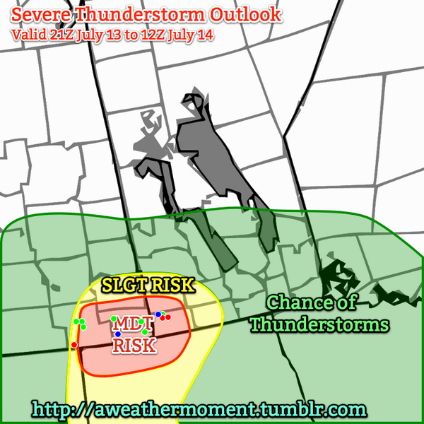
A verification of the AWM Severe Thunderstorm Outlook issued on Saturday morning. Green dots: Severe Hail Reports. Blue dots: severe wind reports. Red dots: tornado reports.

A potent severe weather setup was in place yesterday as a trough of low pressure began to move it’s way from Alberta into the hot, humid air that was pushing into SE Saskatchewan. Ample moisture, heat, instability and wind shear was in place for the development of severe thunderstorms and – given the strongly veering wind profile – the likely development of tornadic supercells. With this in mind, we issued our morning severe weather outlook with a moderate risk for severe thunderstorms in the Estevan, Carlyle, Moosomin, Virden & Melita forecast regions, with a slight risk extending further eastwards into the Pilot Mound & Brandon regions.

Saskatchewan Pounded By Large Hail

Supercell thunderstorm developing just SW of Weyburn, SK at 1900Z.

Supercell thunderstorm developing just SW of Weyburn, SK at 1900Z.

Storms developed earlier than expected; by 1900Z there was a supercell taking shape not too far SW of Weyburn, SK. This supercell ended up being the storm of the day, lasting over 8.5 hours before finally dying near the U.S. border near Gretna, MB. A line of storms quickly developed extending from the main supercell SW into Montana. It rapidly developed into a line of 5 or 6 supercells that all began rotating quickly and producing torrential rain and extremely large hail. Environment Canada had issued a tornado watch for the region around 9:30AM local time which mentioned the threat for supercell thunderstorms capable of producing torrential rain and large hail in addition to the threat for tornadoes.

The reports began flooding in on #SKstorm as the severe storms began impacting larger communities. Environment Canada issued a timeline of reports it received that went like this:

Location Time (Local) Report
Weyburn 1:49 PM Quarter size hail
Hume 2:00 PM Loonie hail
Weyburn (8 km W) 2:21 PM Golf ball hail
Arcola 2:43 PM Funnel cloud
Kisbey 2:45 PM Quarter size hail
Weyburn (5 km W) 2:55 PM Golf ball hail
13 km SE Weyburn 3:00 PM Grapefruit size hail
16 km SE Weyburn 3:00 PM Golf ball hail
Minton (13 km S) 3:15 PM Possible brief tornado
Forget 3:20 PM Golf ball hail
Lampman 4:19 PM 50 mm rain, 80 km/h gust
Redvers 4:29 PM Toonie size hail
Oxbow (8 km N) 4:45 PM 50 mm rain in 15 minutes

Photos that began coming in on Twitter were pretty incredible. Tight lowerings on storms were showing that they were spinning quite intensely and numerous funnel clouds were spotted. But int the end, the big story in SE Saskatchewan was the rain and hail.

Large hail near Weyburn, SK

A photo of large hail near Weyburn, SK. Credit: Craig Hilts

There were numerous reports of tennis ball sized hail upwards to one report of grapefruit sized hail (a grapefruit is around 9cm wide). The hail produced by these storms produced significant damage to crops in the region as well as to personal property, with many reports of car windshields being broken by the hail and images showing up on Twitter of house windows being smashed.

Photo of flooding in Bienfait, SK

Picture of flash flooding in Bienfait, SK. Credit: SK storm chaser @NickTheBody.

Flooding was also a problem in numerous places as the storms dumped unbelievable amounts of rain. At some points, rainfall rates exceeded 200–225mm/h as torrential rain brought zero-visibility conditions. @NickTheBody caught the snap above of the flash flooding that occurred in Bienfait, SK after a thunderstorm rolled through.

Doppler RADAR showing strong couplet near Carlyle, SK

Doppler RADAR showing a very strong couplet as as supercell thunderstorm bears down on Carlyle.

As the storms pushed further east, however, they began to take on some very ominous characteristics. As the storms pushed deeper into the moist, warm air the winds at the surface began to back a little bit more; further west surface winds were mostly out of the south, but as they moved towards the Manitoba border the surface winds became more and more southeasterly. Very quickly strong rotation began to show up on RADAR, with the main supercell we’ve been tracking showing a very intense velocity couplet as it moved towards Carlyle, SK. The storms had always shown rotation since nearly the beginning of their lifespan and had the capability to produce tornadoes at any time, but it was at this point these storms began to look like they could produce a large, long-lived tornado. The storm about to hit Carlyle, in particular, was becoming the storm to watch.

Supercell Tears Across Southwest Manitoba

And watching it we were! Matt, A Weather Moment contributor and @lovestormsMB was out chasing and had been on the storm for hours at this point. While hopes of seeing anything rapidly diminished as the storm became what is known as a HP supercell[1], he was able to feed important information via his Twitter account.

Supercell thunderstorm over SE SK / SW MB

HP Supercell just SW of Carlyle, SK on Saturday evening as the storm approached the Manitoba border. Credit: @lovestormsMB

This storm – for lack of any better terminology – looked vicious as it moved into Manitoba. It was tracking along Highway 13 and moved straight towards Reston – a town that has already had to deal with multiple severe storms this year already – and Pipestone, a town somewhat famous for the Pipestone tornado.

Unfortunately, it didn’t take long for word to come that there was certainly significant damage occurring under that storm. Environment Canada also issued a timeline for reports it received on the Manitoba side:

Location Time (Local) Report
Sinclair (7 km N) 6:00 PM Ping pong size hail, severe winds with trees down
Reston 6:49 PM Nickel hail, 42 mm rain
Pipestone 7:00 PM Tornado, significant damage
Pipestone (20 km E) 7:30 PM Tornado, golf ball hail
Hartney 8:00 PM Possible tornado

Dramatic photos began coming in from the Pipestone region as well:

HP Supercell Approaching Pipestone

Photo of the HP supercell near Reston, approaching Pipestone, MB. Credit: @lovestormsMB

Downed tree in Pipestone

Photo of a large tree snapped in half in Pipestone. Credit: Tim Smith / Brandon Sun

Mobile home thrown into the rink in Pipestone

Photo of a mobile home thrown into the rink in Pipestone. Credit: @Snipe_All_Day

Destroyed cattle shed in Hartney, MB

A destroyed cattle shed in Hartney, MB. Credit: @LD_StVital

The clean-up continues today in Pipestone and Hartney while damage continues to be assessed in southeastern Saskatchewan. Unfortunately for those in Saskatchewan there will be little time to recover as another potent setup for a severe storm outbreak will be in place Monday afternoon bringing, once again, a tornado, torrential rain and large hail risk. Regions in SW Manitoba should be a little safer this time. We’ll have the full details of that in tomorrow’s blog post.


  1. The “HP” in “HP supercell stands for ”high precipitation.” HP supercells often have obvious, dramatic structure form afar, but little of the internal workings are visible due to the copious amounts of precipitation falling out from them. HP supercells are extremely dangerous storms as any tornadoes they produce are often hidden from sight behind all the rain.  ↩