Warm Weather Continues With A Chance of Thunderstorms

The warm temperatures will continue in Winnipeg right through the weekend, but a couple disturbances moving through will bring several chances of showers or thunderstorms to the region.

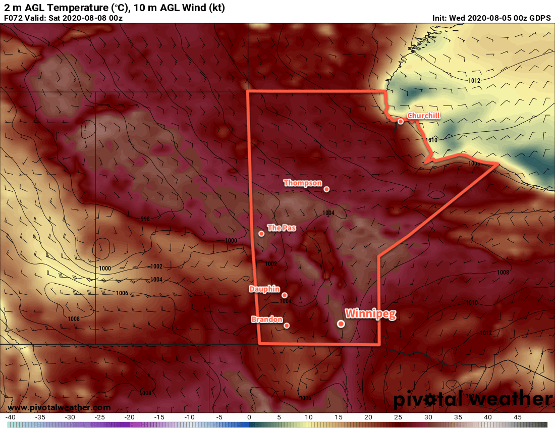
Temperatures will soar back into the low 30s in Winnipeg today with slightly humid conditions. Mainly sunny skies this morning will give way to increasing cloud this afternoon as a disturbance approaches the region this afternoon. By mid-afternoon, the Red River Valley will begin to see a chance of thunderstorms spreading eastwards. Today’s storms could produce severe weather across the region; the main threats will be torrential rainfall and large hail, but isolated severe wind events will also be possible. While a tornado is possible today, it will not be a primary threat.

3km NAM Forecast Simulated RADAR Reflectivity valid 00Z Saturday August 22, 2020
Most forecasts show a line of thunderstorms entering the Red River Valley by 6 PM.

Showers or thunderstorms will continue to be possible into the night, although the chance is significantly less after midnight. Temperatures will dip to a low near 18°C.

Severe Weather Setup

Friday will pose a notable severe weather threat over southern Manitoba. The triggering weather feature will be a trough of low pressure pushing eastwards through the region. The thermodynamic environment will be favourable for severe weather. Surface dew points in the 17–18 °C range will support MLCAPE values near 2000 J/kg. There is a bit of uncertainty with the moisture depth, but mid-level drying between 700 and 500 mb will also support storm development.

Dynamics are a little less favourable, though, with a disjointed veering hodograph with relatively light winds. Bulk shear (0–6 km) values are forecast to sit around 25 knots, marginally supportive for severe storms. Thunderstorms will struggle with weak mid-level winds, though, and will have to rely on broader synoptic support to get organized.

Precipitable water is forecast to sit in the 30–40 mm range, high enough o support torrential rainfall. Fortunately, storm motion is forecast to be 25 to 40 km/h. Thunderstorms won’t likely be sitting over any one location for too long.

SHARPpy Forecast 3km NAM Sounding for Winnipeg valid 00Z August 22, 2020
Most forecast soundings show a moderately unstable environment by late Friday.

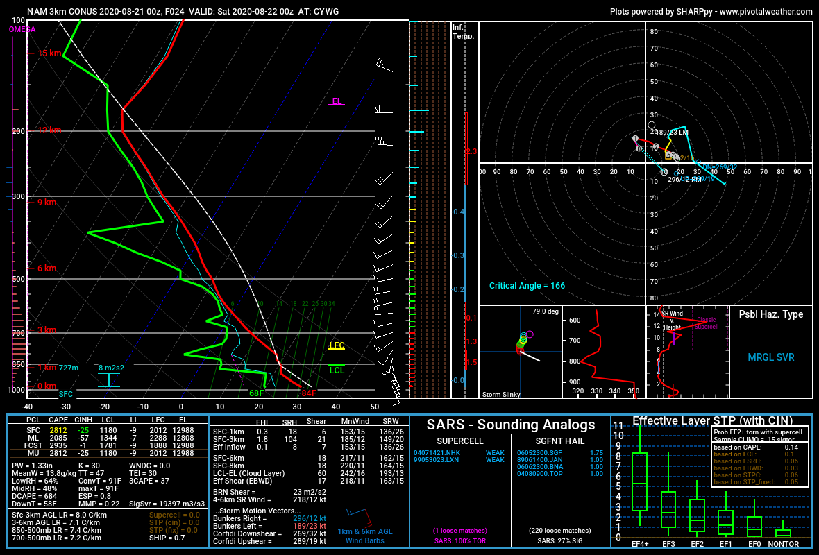
All this combines to produce a primary threat of damaging hail, supported by large MLCAPE values, marginal shear, and the potential for a favourable dry layer in the mid-levels. Torrential rainfall is also a threat but thunderstorms will likely be moving quickly enough that any one location won’t see problematic accumulations.

Damaging wind gusts will be a secondary threat, but will only be possible if thunderstorms are able to organize enough to produce upscale growth into some sort of MCS. In that case, wind profiles would support the potential development of bow echoes and the associated damaging winds. Lastly, a tornado is possible but would require extensive local-scale modification to the dynamics by a strong thunderstorm. The synoptic support resembles something that could support tornadoes, but a lot of the details aren’t entirely right. That said, be sure to keep watch for any alerts issued by Environment and Climate Change Canada later today for any potential severe weather.

The Weekend

Aside from the chance of an early morning shower, Saturday should be a dry day. Skies will start out fairly cloudy then gradually clear midday into the afternoon. By the evening, Winnipeg should see plenty of sunshine with temperatures in the upper 20s. The city will see a low near 16°C on Saturday night with mainly clear skies.

On Sunday, another surge of warmer air followed by a cold front will move through the region. Winnipeg should see a high back near 30 °C with partly cloudy to mixed skies. As the cold front pushes into the region in the afternoon, a chance for showers or thunderstorms will spread into the Red River Valley and persist into the evening hours. The cloud cover will break up overnight with a low near 16°C.

Long Range Outlook

Next week will bring a return to near-seasonal temperatures. Daytime highs will hover in the mid-20s with overnight lows cooling to the low teens. A zonal flow aloft will develop, meaning the region will see a fair amount of sun, but occasional disturbances bringing showers and thunderstorms will be possible.

Today’s seasonal daytime high in Winnipeg is 24°C while the seasonal overnight low is 11°C.

Summer Heat Building Back In

Temperatures in Winnipeg will begin to climb back towards the 30s over the coming days.

A weakening trough of low pressure will move through Winnipeg today, bringing mild temperatures and light south winds. With partly cloudy skies, the city should see a high near 27 °C. Skies will clear for the night with a low near 16 °C.

On Thursday, a ridge of high pressure will lie draped across southern Manitoba and southeastern Saskatchewan. This will bring mainly sunny skies to Winnipeg with light southerly winds. Temperatures will be a bit warmer with a high near 29 °C, but humidity levels should still be comfortable. Thursday night should see a low near 17 °C.

GDPS 2m Temperature Forecast valid Saturday August 8, 2020
Hot summer weather will return to the Red River Valley on Friday.

Friday will be when the hot and humid weather settles back into the region. Winnipeg will see temperatures climb to a high near 32 °C and a breezy southerly wind will draw humid conditions northwards. By the end of the day, the dewpoint is forecast to reach almost 20 °C which would make for noticeably muggy conditions.

A cold front will push eastwards across the region on Friday evening into the night. It looks likely that it will support an area of showers and thunderstorms as it moves through.

Long Range Outlook

The weekend will bring more sunshine with a return to comfortable humidity levels. Both Saturday and Sunday will see high temperatures in the upper 20s.

Today’s seasonal daytime high in Winnipeg is 26°C while the seasonal overnight low is 13°C.

Unsettled Friday Followed By A Beautiful Long Weekend

A cold front pushing through southern Manitoba will bring unsettled conditions today, but a high pressure system will usher in beautiful summer conditions for the long weekend.

Today’s main weather-maker will be a cold front will pushing across the Red River Valley. Winnipeg will start the day with remnant cloud cover from the night’s thunderstorms. Skies will become mixed later this morning as showers and thunderstorms develop ahead of the advancing front. Temperatures should reach a high around 26 °C this afternoon with dew points climbing to a muggy 19 °C.

The unsettled weather will move through in the afternoon, then push off to the southeast in the evening. We do not any severe weather in Winnipeg, but high dew points will likely result in locally heavy rainfall. To the south and east, there’s a chance for isolated severe thunderstorms that could produce large hail alongside heavy rain.

NAM 12hr. Accumulated Precipitation Forecast valid 03Z Saturday August 1, 2020
Much of southern Manitoba is expected to see showers and/or thunderstorms today.

Northerly winds up to 30 km/h will develop this evening behind the cold front, ushering in a drier air mass. Temperatures will dip to a low near 14°C under mainly clear skies.

Behind today’s instability comes a beautiful long weekend. A sprawling area of high pressure will gradually build into the province this weekend, bringing plenty of sunshine and seasonal temperatures. The wind will continue to be breezy out of the north on Saturday, but will ease into the 15–25 km/h range for Sunday.

Long Range Outlook

There’s nothing but beautiful summer weather in the long-range forecast, with mainly sunny skies and seasonal temperatures persisting right into the middle of next week. The second half of the week may bring gradual warming with variable cloudiness.

Today’s seasonal daytime high in Winnipeg is 26°C while the seasonal overnight low is 13°C.

Sweltering Summer Heat Returns To Winnipeg

A hot and increasingly humid air mass will bring sweltering summer heat back to Winnipeg.

Get the sunscreen out and make sure that A/C is working: sweltering summer conditions are on their way to Winnipeg! An upper ridge will develop a deep southerly flow through the American Plains and southeastern Prairies, pushing heat and humidity northwards into the region.

Today, Winnipeg will see a high near 27°C with brisk southerly winds of 30 gusting 50 km/h develop. A passing upper disturbance will bring a few clouds to the region this morning, followed by mainly sunny skies for the afternoon. Humidity levels will stay comfortable today. The winds will persist out of the south at around 20 km/h tonight with clear skies and a low near 16°C.

On Thursday, the southerly winds will pick up to 40 gusting 60 km/h as muggier conditions develop over the region. The city will see a high near 29°C with dew points climbing into the upper teens. The muggier conditions will be slightly offset by the wind, but it’ll still feel fairly muggy. Winds will keep up out of the south at around 30 km/h on Thursday night with a low near 20°C.

GDPS 2m Dew Point Temperature Forecast valid 18Z Friday July 24, 2020
Very muggy conditions will develop over southern Manitoba on Friday.

A trough of low pressure pushing eastwards on Thursday night will bring a risk of thunderstorms to southern Manitoba. For Winnipeg and the Red River Valley, the main threat looks to exist between 4 A.M. and 7 A.M. early Friday morning. These thunderstorms, if they develop, could be severe with a primary threat of damaging wind gusts and large hail. Rainfall with these thunderstorms may be intense, but the storms will be moving quickly which will limit accumulations.

Friday morning will see cloudy conditions in the wake of any potential convection, then skies should mix out midday. It will be an oppressively hot afternoon in Winnipeg with a high near 34°C and dew point in the low 20s. Humidex values in the the low 40s will seem even more oppressive as winds ease in the afternoon.

Winnipeg will see partly cloudy skies on Friday night with a low near 22°C.

Long Range Outlook

Saturday will bring more hot and humid weather to Winnipeg alongside unsettled conditions as a cold front sweeps through later in the day. Brisk northwest winds will bring seasonal conditions and plenty of sunshine back to the region for Sunday. Next week looks to bring seasonably mild conditions with plenty of sunshine and comfortable humidity levels.

Today’s seasonal daytime high in Winnipeg is 26°C while the seasonal overnight low is 13°C.