Summer returns to Winnipeg as hot and humid conditions move in to start the week.
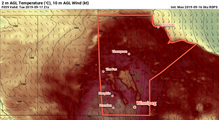
Winnipeg will see hot and humid weather today with plenty of sunshine. The city will see a high near 29°C today with notable humidity developing for the afternoon. Dew point temperatures will rise to 19 to 20°C by the end of the day, making it feel quite muggy out. Winds will be relatively light today out of the southeast at 20 km/h.
Humid conditions will continue tonight, keeping temperatures warm. The city will see a low of just 20°C with a few clouds moving in.
The hot and humid weather continues on Tuesday with a high near 30°C and partly cloudy skies. Winds will be stronger, increasing out of the south to around 30 gusting 50 km/h by the end of the day. Temperatures will head to a low near 20°C again on Tuesday night under mixed skies.
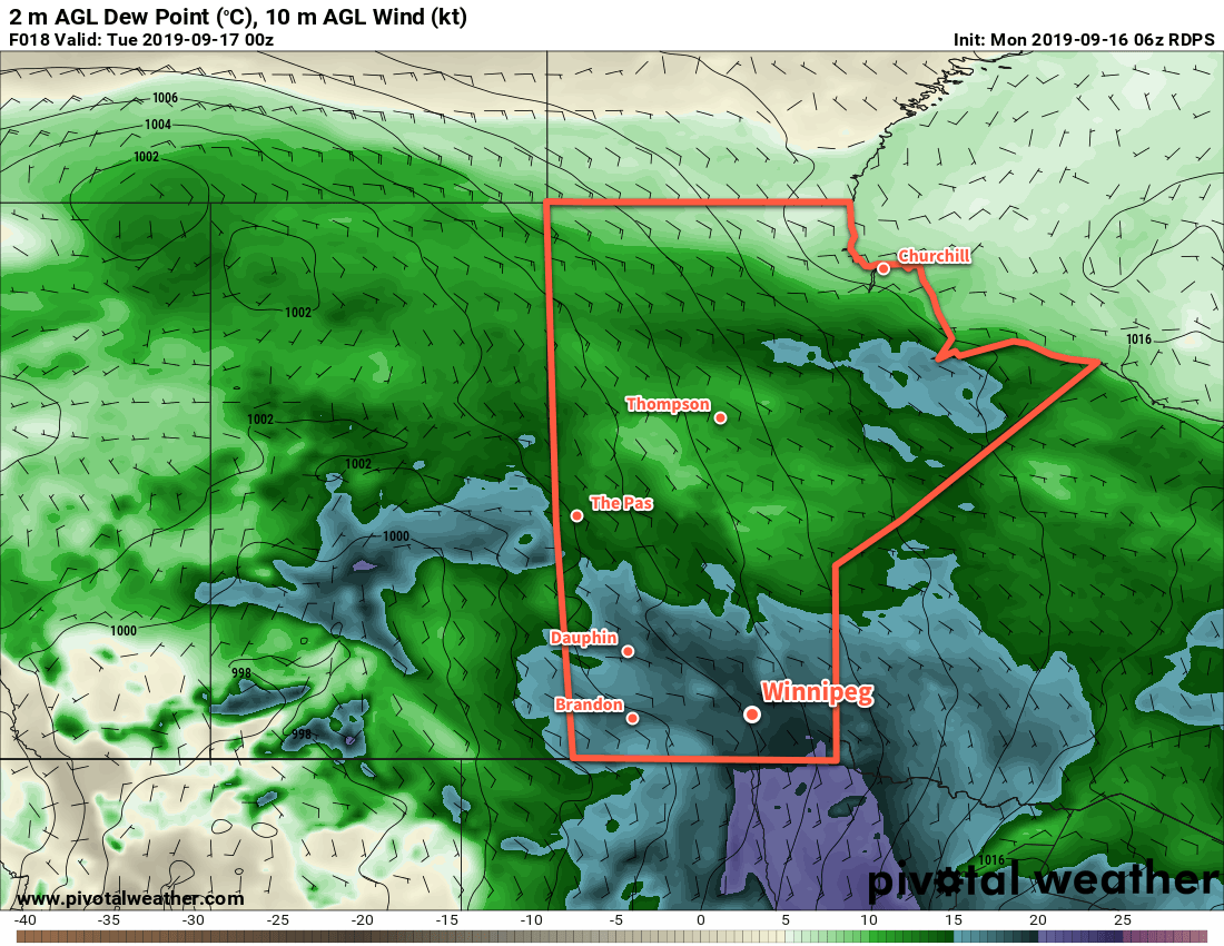
Dew point values will settle near 20°C by the end of the day on Monday, making it feel very humid.
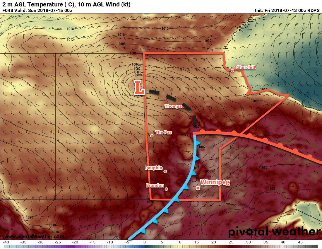
The heat will finally break on Wednesday as a low pressure system moves through the region. As it moves through, it will bring mixed to cloudy skies with a chance of showers or thunderstorms. Winds will shift westerly in the morning and increase to around 30 gusting 50 km/h. The humidity will stay for much of the day with dew points remaining in the upper teens. A cold front will push through on Wednesday evening, bringing northwesterly winds to the region that will push the humidity out. Temperatures will dip to a low near 12°C.
The warm nights ahead won’t just be seasonably mild, they may end up being record breakers. New record warm minimum temperatures may be set for September 17 and 18th. If temperatures stay above 20°C on both days, it will easily beat the current records of 17.8°C (1946) and 15.6°C (1964) respectively.
Long Range Outlook
The second half of the week will continue to be seasonably warm with daytime highs in the mid-twenties. Humidity will return to the region on Friday ahead of a major low pressure system. Showers and thunderstorms will spread across southern Saskatchewan into Manitoba on Friday. Unsettled weather will move through the region on Saturday, followed by calmer conditions and seasonal temperatures on Sunday.
Today’s seasonal daytime high in Winnipeg is 18°C while the seasonal overnight low is 6°C.
Hot and increasingly humid weather is on the way for Winnipeg, bringing sweltering summer heat and unsettled conditions.
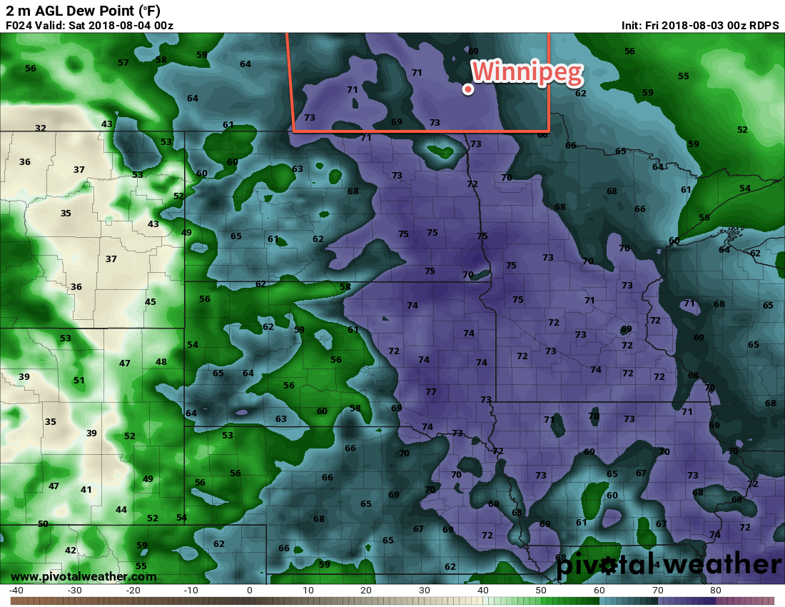
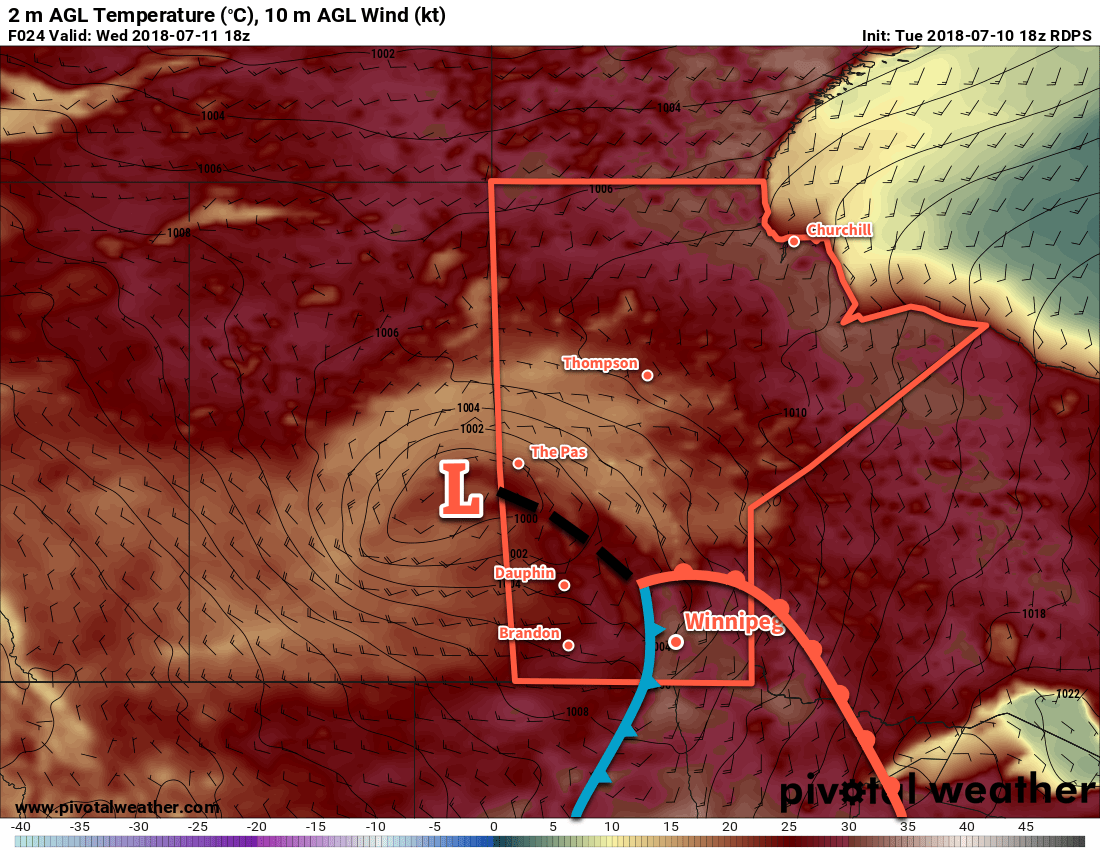
Summer will return in full force to Winnipeg today. An approaching low pressure system moving in from Saskatchewan has drawn significantly warmer air northwards overnight, and will continue to tap into a hot and increasingly humid air mass through the day. Temperatures will quickly climb into the mid-20s today, then head towards a high near 30°C. Dew point values – a measure of the humidity – will also climb into the 17-19°C range by the late afternoon. This is high enough that it will start to feel muggy outside and it will produce a humidex value in the mid-30s.
High dew points will bring muggy conditions to southern Manitoba this afternoon
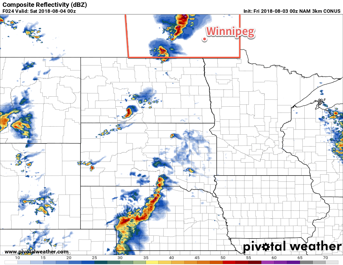
All this heat and humidity will, naturally, result in fairly unstable conditions from the Manitoba Interlake all the way south to the American border. MLCAPE values will climb into the 2000 to 2500 J/kg range by late afternoon, but a capping inversion of at least 60 J/kg should keep everything suppressed until late in the day. Shear is excellent in the Interlake with 0-6 km values in the 40 to 50 kt range with south-southeasterly winds at the surface veering to westerly aloft. Further south in the Red River Valley, shear values aren’t quite as favourable with 0-6 km values in 30 to 35 kt range and the capping inversion is slightly stronger.
As the Saskatchewan low tracks into western Manitoba in the afternoon and onwards to the Interlake, it will likely support an area of thunderstorm activity. These thunderstorms will be strong to severe with primary threats of large hail and damaging winds, and – while not a marked threat – an isolated tornado is possible.
Further south in the Red River Valley, a trough of low pressure extending southwestwards from the low will move into the region late in the day. There’s still a whole lot of uncertainty as to whether or not any thunderstorms will be able to develop along it. If thunderstorms manage to develop along the trough, it would likely be in the early evening, west of the Red River Valley, then progress eastwards over the next several hours. These storms would be strong to severe with the primary threats of large hail and damaging winds. Again, that’s only if they’re able to develop. Either way, with enough of the recipe in place today, it wouldn’t be a bad idea just to keep an eye out in case Environment Canada issues any watches or warnings.
Some high-resolution models show a line of thunderstorms breaking out late in the day over southern Manitoba
Everything should clear out by late evening, and Winnipeg will head to a low near 20°C. More cloud cover will move in early Saturday morning as a new upper-level disturbance begins lifting into the region from the United States.
As the upper-level disturbance moves into Manitoba on Saturday morning, it will likely bring an area of showers or thunderstorms with it. Timing is uncertain on this right now, but it will likely impact the region beginning sometime mid-morning until the early afternoon. Once it moves out, it will leave behind partly cloudy skies. High temperatures will depend significantly on how quickly it can move through the region. Right now it looks like the high temperature will reach around 26°C once the sun gets shining in the afternoon. If the system moves through faster it may get a bit warmer, or if it’s slower than it might be ac couple degrees cooler. Skies will clear out for the evening as temperatures head to a low near 18°C.
A cold front passing through late Saturday night will bring more cloud back into the region for Sunday. Northwesterly winds near 30 km/h will lower humidity levels and bring a cooler daytime high in the low 20s to Winnipeg. Forecasts currently show the Red River Valley under mainly cloudy skies for much of the day with a chance of showers. The winds will ease in the evening alongside clearing skies. Winnipeg should see a low on Sunday night near 15°C.
Long Range Outlook
Seasonal to above-seasonal temperatures will return to start next week and persist through to the end of the week.
Winnipeg’s seasonal daytime high is currently 26°C while the seasonal overnight low is 13°C.
A heat warning is in effect for Winnipeg with another two days of sweltering, increasingly humid, weather on the way. A cold front will move through Saturday evening, though, bringing a risk of thunderstorms and a return to seasonal temperatures.
Winnipeg will see daytime highs well over 30°C both today and tomorrow as an upper level ridge moves through. Temperatures will climb to a high near 32°C today under sunny skies. Winds will increase out of the west-northwest from light this morning into the 20-30 km/h range this afternoon. Winds will diminish to light tonight as temperatures dip to a low near 19°C. Saturday will be a scorcher. Southerly winds will strengthen to 40 gusting 60 km/h and draw a more humid air mass northwards. With highs expected to reach 34 or 35°C alongside dew points in the upper teens, Winnipeg will see another day with humidex near 40.
A sharp cold front will surge southeastwards through the Red River Valley on Saturday evening.
A sharp cold front sweeping southeastwards will bring a moderate threat of severe thunderstorms to the Red River Valley late Saturday afternoon into the evening. Going over the MIST ingredients:
Moisture: While surface moisture will likely be plentiful, it won’t be particularly deep. The southerly wind should help sustain moisture transport, though, with deeper moisture near the cold front likely as it pools.
Instability: With high surface moisture, SBCAPE values are impressive with over 3500 J/kg forecast. However, MLCAPE values will likely be substantially less in the 1000 to 2000 J/kg range as the moisture drops off with elevation.
Shear: Shear is moderate with 25 to 35 kt of 0-6 km bulk shear forecast. As storms progress into the evening, 20 to 30 kt of effective shear is forecast.
Trigger: Strong convergence along a cold front sweeping southeastwards.
The most likely scenario at this point looks like scattered thunderstorms will develop along the cold front in the late afternoon, stretching from the southern Interlake into southwestern Manitoba. These storms will push southeastwards into the Red River Valley, but timing will be important; winds are forecast to weaken aloft as the evening progresses, likely meaning that these thunderstorms will weaken as the evening progresses. The primary threat these storms will pose will be damaging hail and/or winds. The tornado threat looks low right now.1
Winds will shift north-westerly behind the cold front at 15 to 25 km/h as temperatures head to a low near 15°C.
Sunday will be a relatively pleasant day in Winnipeg. Temperatures will climb to a seasonal high near 25°C under partly cloudy skies, but winds will strengthen out of the west to around 30 gusting 50 km/h. Winds will ease on Sunday night with a low near 14°C.
Long Range Outlook
Winnipeg will see plenty of sunshine to kick off next week with slightly below-seasonal to seasonal temperatures. Warmer weather returns mid-week as an upper ridge builds back into the eastern Prairies. Unfortunately, rainfall remains elusive. No widespread relief is on the way for agricultural regions beginning to experience heat and moisture stress.
Winnipeg’s seasonal daytime high is currently 26°C while the seasonal overnight low is 13°C.
If surface winds back a little more than currently forecast, tornadoes may be a threat with these thunderstorms, primarily through the late afternoon and early evening. ↩
After an unsettled start early Wednesday morning, Winnipeg will see plenty of sunshine and hot weather for the remainder of the work week.
Winnipeg will see a generally unsettled morning today as a low pressure system rolls into Manitoba. The bulk of it will have occurred with the convective complex that has moved through the city early this morning, but a few more showers are possible along a cold front moving through later today. Before that happens, hot and muggy conditions will develop under mixed skies; temperatures will climb to a high near 32°C with dew points near 20°C. This will result in humidex values in the upper 30s. Once the cold front moves through, any lingering chance for showers will taper off, skies will clear, and drier air will begin working into the region from the west. Winnipeg will see a mild low near 19°C tonight under clear skies.
The next two days will bring more beautiful summer weather to the city as a ridge of high pressure builds in. Winnipeg will see mainly sunny skies both Thursday and Friday with daytime highs near the 30°C mark. Conditions won’t be too humid, and both days will see westerly winds; Thursday should see stronger winds in the 30 to 40 km/h range while lighter winds near 20 km/h move in for Friday. Lows will continue to be mild in the 17 to 20°C range.
Long Range Outlook
More warm weather is on tap for Saturday with daytime highs once again climbing above 30°C. A strong cold front passing through on Saturday night looks to bring a risk of thunderstorms to the region, followed by the arrival of a more seasonal air mass. The start of next week looks to bring plenty of sun, daytime highs in the 23 to 27°C range, and overnight lows in low to mid-teens.
Winnipeg’s seasonal daytime high is currently 26°C while the seasonal overnight low is 13°C.