Cooler With A Chance of Showers to End the Work Week

After record-setting heat yesterday, a change is in the weather as unsettled conditions today lead to cooler temperatures for the weekend.

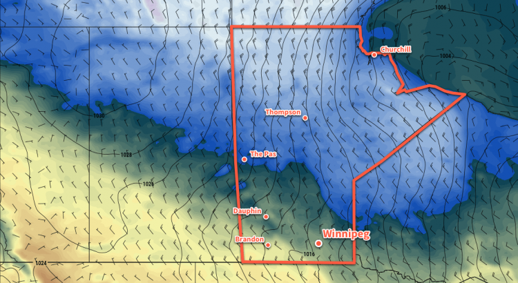
Winnipeg’s sunny skies of yesterday will be replaced by mixed to mostly cloudy skies today. A cold front passed through the region overnight, ushering in northwesterly winds for today that will keep conditions much cooler than yesterday. With breezy northwesterly winds near 30 gusting 50 km/h, Winnipeg should see a high near 8°C today.

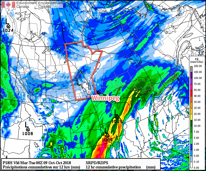
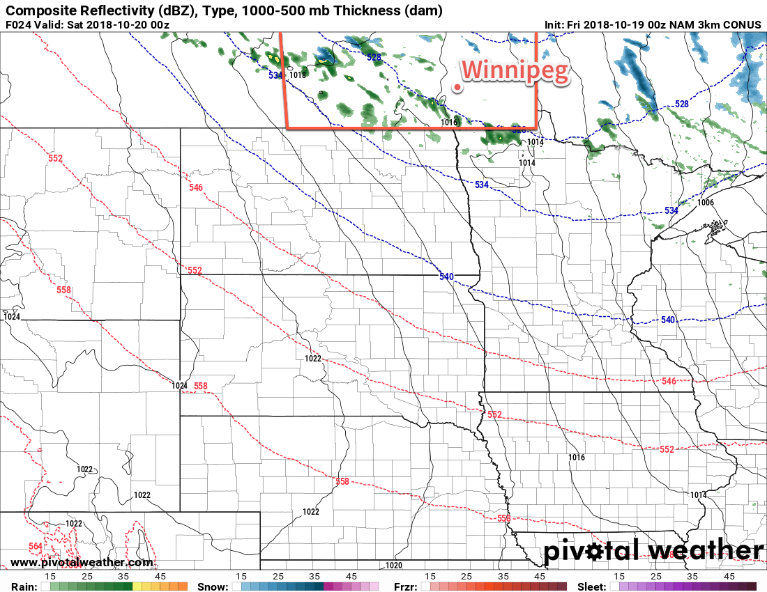
A second cold front will sweep through the region late in the day as Arctic air surges southwards behind the low pressure system that brought the mild temperatures to the region yesterday. As the front pushes through, it will bring a chance of showers to the Red River Valley for the late afternoon into the evening. Cooler temperatures will continue to spill southwards through the night as the northwesterly winds continue. There will be a chance for flurries in the lee of the Manitoba Lakes right through the overnight period. Winnipeg will see a low near -3°C under mixed skies.

3km NAM Simulated RADAR Reflectivity with Type valid 00Z Saturday October 20, 2018
Scattered showers will spread across portions of southern Manitoba as a cold front slumps through late Friday afternoon.

Saturday will be a very cool day as an Arctic high moves across the region. Winds will diminish through the morning as temperatures climb towards a high of just +3°C. Skies should be partly cloudy with more organized bands of stratus coming off of the lakes to both the west and east of Winnipeg. Heading into the night, more cloud will move into the region as a warm front pushes across the province. Winnipeg will see a low near -1°C with southerly winds near 20 km/h.

Sunday should bring mainly sunny skies to Winnipeg as the cloud pushes off to the east. With the warm front through, the city should see a more seasonable high of around 10°C with light winds. It’s looking like Sunday will actually be quite a pleasant fall day! Temperatures will head to a low near +1°C on Sunday night with light westerly winds.

Long Range Outlook

Next week looks set to bring closer to seasonal conditions. Daytime highs in the mid- to upper single digits are forecast alongside variably cloudy skies. It also appears that it will remain dry with no notable precipitation in the forecast.

Winnipeg’s seasonal daytime high is currently 9°C while the seasonal overnight low is -1°C.

More Cloudy and Cool Weather Ahead

It’s more of the same for Winnipeg as temperatures remain below seasonal under mostly cloudy skies.

Winnipeg will see cool, cloudy conditions over the next few days as the city remains caught between a large Arctic ridge to the northwest and a developing Colorado Low to the south. Today Winnipeg will see a high near 6°C under mostly cloudy skies. There’s a slight chance of drizzle or light rain over Winnipeg and the Red River Valley, particularly this morning and then later in the day.

Winds will be light out of the north at 10 to 20 km/h. Temperatures will head to a low near +2°C tonight. Tomorrow will bring more cloud to the region and a high near 5°C. Winds will begin picking up, though, out of the north to around 30 km/h. Skies remain cloudy Tuesday night as temperatures head to a low near 0°C.

Winnipeg will see a chance of light rain or drizzle today, but organized rain will be passing by to the south and east.

Wednesday will bring the chance for rain or snow back to the region as an inverted trough extending from a Colorado Low over Wisconsin pushes into the region. There’s a lot of uncertainty associated with this right now due to a variety of unknowns. Perhaps on of the biggest contributors of uncertainty is an Arctic high parked over northern Manitoba as the system approaches.

The northerly winds in place over the southern half of the province will be tapping into the very dry air from the high over the northern half. This dry air will slide underneath the precipitation as it tries to push northwards out of the Dakotas. Exactly how significantly this dry air will impact the precipitation as it tries to push northwards is unknown; often it can reduce or eliminate the precipitation by evaporating it before it reaches the ground. That said, if there is enough support, Winnipeg may see some snow or rain on Wednesday at some point.

With a northerly breeze at 20 to 30 km/h tapping into that Arctic high, temperatures will be cool. Winnipeg will see a high near +2°C and a low overnight near -3°C.

Long Range Outlook

Winnipeg may see some sun in the second half of the work week, but cool temperatures will remain. The chance for rain or snow will return on Saturday, but by the start of next week, a large-scale pattern change begins! Temperatures are forecast to gradually increase back into the upper single digits by the middle of next week. By next weekend, Winnipeg may actually see a return to seasonal temperatures!

Winnipeg’s seasonal daytime high is currently 13°C while the seasonal overnight low is +2°C.

Friday Brings Wintery Mix, Comparatively Pleasant Weekend Ahead

Winnipeg will see another wet day today as a wintery mix of precipitation falls over the Red River Valley. By comparison, the cool but dry weekend will seem pleasant!


Winnipeg will see another cold, wet day of snow and rain today. A low pressure system moving through North Dakota will spread an area of snow across southern Manitoba early this morning. Temperatures will remain cool with a high near +2°C, but may warm just enough to mix the snow with rain this afternoon. The snow/rain will taper off this evening, leaving the city with mostly cloudy skies and just a slight chance of some flurries through the remainder of the evening. Temperatures will head to a low near -1 or -2°C.

From snow in the southwest to rain in the southeast and a wintery mix between the two, southern Manitoba will see another wet day today.

Fortunately the weekend will bring slightly improved conditions, but the region will still remain way below seasonal temperatures. Winnipeg should see a mix of sun and cloud on Saturday with temperatures reaching a high near 5°C. Skies will remain mixed on Saturday night as temperatures dip to a low near -4°C.

Sunday will bring cloudier conditions back to the region ahead of the next low pressure system on the way. Under mostly cloudy skies, Winnipeg should see temperatures reach a high near 7°C. It looks likely that some light rain will move into the Red River Valley on Sunday night as temperatures dip to a low near +1 or +2°C.

The winds will remain light through the weekend.

Long Range Outlook

More rain will move through the region on Monday, followed by a week of mixed to mostly cloudy skies and cool temperatures. Temperatures will remain well below normal with highs generally around 5°C and overnight lows near or just below 0°C.

Winnipeg’s seasonal daytime high is currently 14°C while the seasonal overnight low is +2°C.

Wintery Mix on Wednesday Sets Stage for Prolonged Cold Snap

A cold, wet and windy Wednesday in Winnipeg will give way to…more cloudy and cold conditions.

Winnipeg is in for a cold, wet day today. A rapidly strengthening low pressure system tracking through Minnesota has spread rain across southern Manitoba this morning. The rain will further organize and intensify this afternoon, bolstered by an upper-level trough moving into the region. The complicating factor today will be a cold front that surges southeastwards this afternoon. Behind it, temperatures will fall to around +2°C with strong northwesterly winds of 40 gusting 60 km/h. Given the significantly cooler temperatures, it seems quite likely that the rain will change over to snow behind the front. The precipitation will taper off in the evening.

There are two possible outcomes today: either the rain holds out for much of the day and it doesn’t change over to snow until late in the afternoon, or it changes over to snow once the heavier precipitation moves in for the afternoon. In the case of the former, Winnipeg would likely see around 10 mm of rain and possibly a couple cm of snow that sticks to grassy surfaces. In the case of the latter, Winnipeg could see near 5 cm of wet snow that leaves grassy areas covered and roads slushy.

Southern Manitoba will see a swath of 10-15 mm of liquid-equivalent precipitation today; some of that will likely fall as snow.

The gusty northwesterly winds will persist into the evening before diminishing overnight as a ridge of high pressure moves in. Skies will clear through the evening but a few clouds will likely stream off of Lake Manitoba for a portion of the night. Winnipeg will see a low temperature near -5°C.

On Thursday, Winnipeg will see just a few clouds with light winds for much of the day. Temperatures will rebound slightly with a high near 6°C. Heading into the evening, skies will cloud over ahead of the next low pressure system moving into the Northern Plains. Temperatures will dip to a low near 0°C. Through the second half of the night, it’s likely that some light rain or snow will push northwards into the Red River Valley.

Friday will bring another cloudy day with periods of light rain or snow. Light northeasterly winds will keep temperatures cool. Winnipeg will see a high near +4°C. Accumulations won’t be too much with under 5 mm forecast for the Red River Valley right now. Most of the precipitation will taper off in the evening, but skies will remain mostly cloudy through the night. A few flurries will be possible overnight off of Lake Manitoba. Winnipeg will see a low near 0°C.

Long Range Outlook

Unfortunately, the long-range forecast still stinks. Plenty of cloud will persist while the chance for rain potentially intermingled with some soggy snow returns Sunday night into Monday. High temperatures will continue way below normal in the mid- to low single digits right through the end of next week. Nothing to say but terrible weather for this time of year.

Winnipeg’s seasonal daytime high is currently 14°C while the seasonal overnight low is +3°C.