Cool and Unsettled Conditions Continue

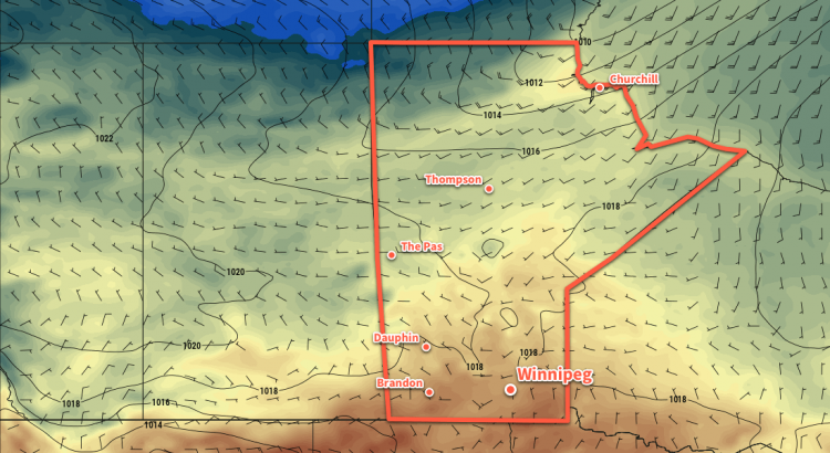
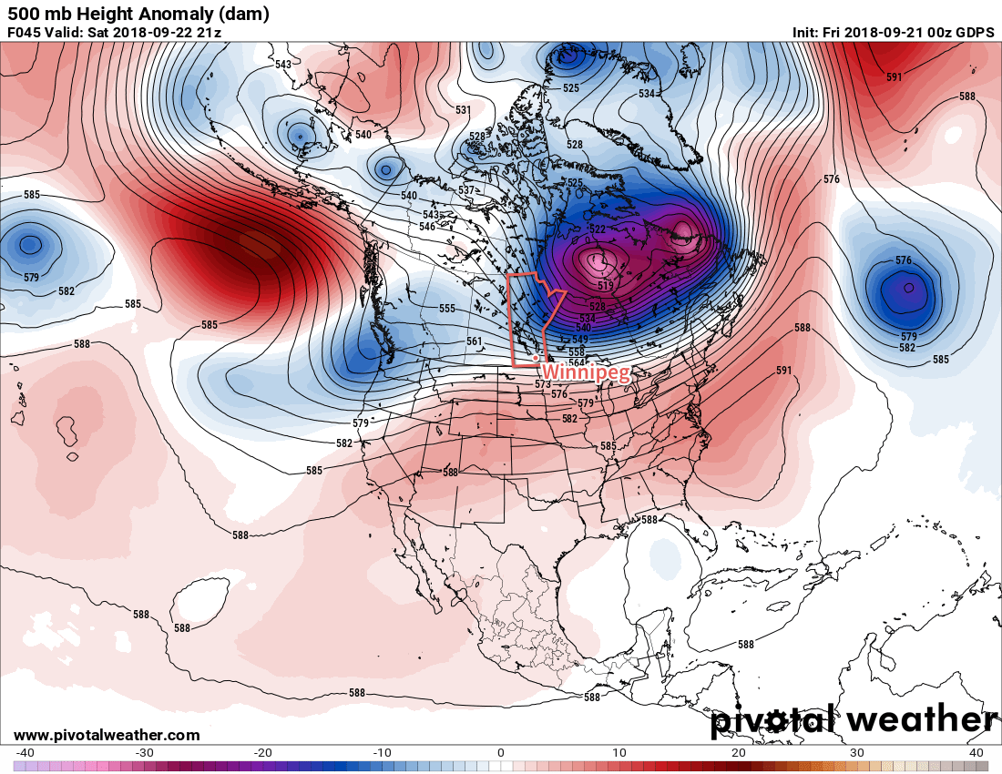
A large Arctic vortex over Hudson Bay will keep cooler air entrenched over Manitoba right through the weekend.

Today will be the sunniest, warmest day Winnipeg will likely see for a while. Cloud cover from the rain overnight will break up this morning, leaving Winnipeg with sunny to partly cloudy skies. Temperatures will remain below-seasonal with a high of 13°C after northerly winds taper off in the morning.

Two primary features will define the weather from Friday evening onwards through the weekend: a large Arctic high building southeastwards through the Prairies and a nearly stationary front over the northern United States. This front will have several upper-level disturbances slide along it, bringing cloudy and occasionally unsettled conditions to southern Manitoba.

GDPS 500mb Height Anomaly Forecast valid 21Z Saturday September 22, 2018
An unseasonably strong vortex over Hudson Bay will continue to keep Winnipeg entrenched in a cooler air mass.

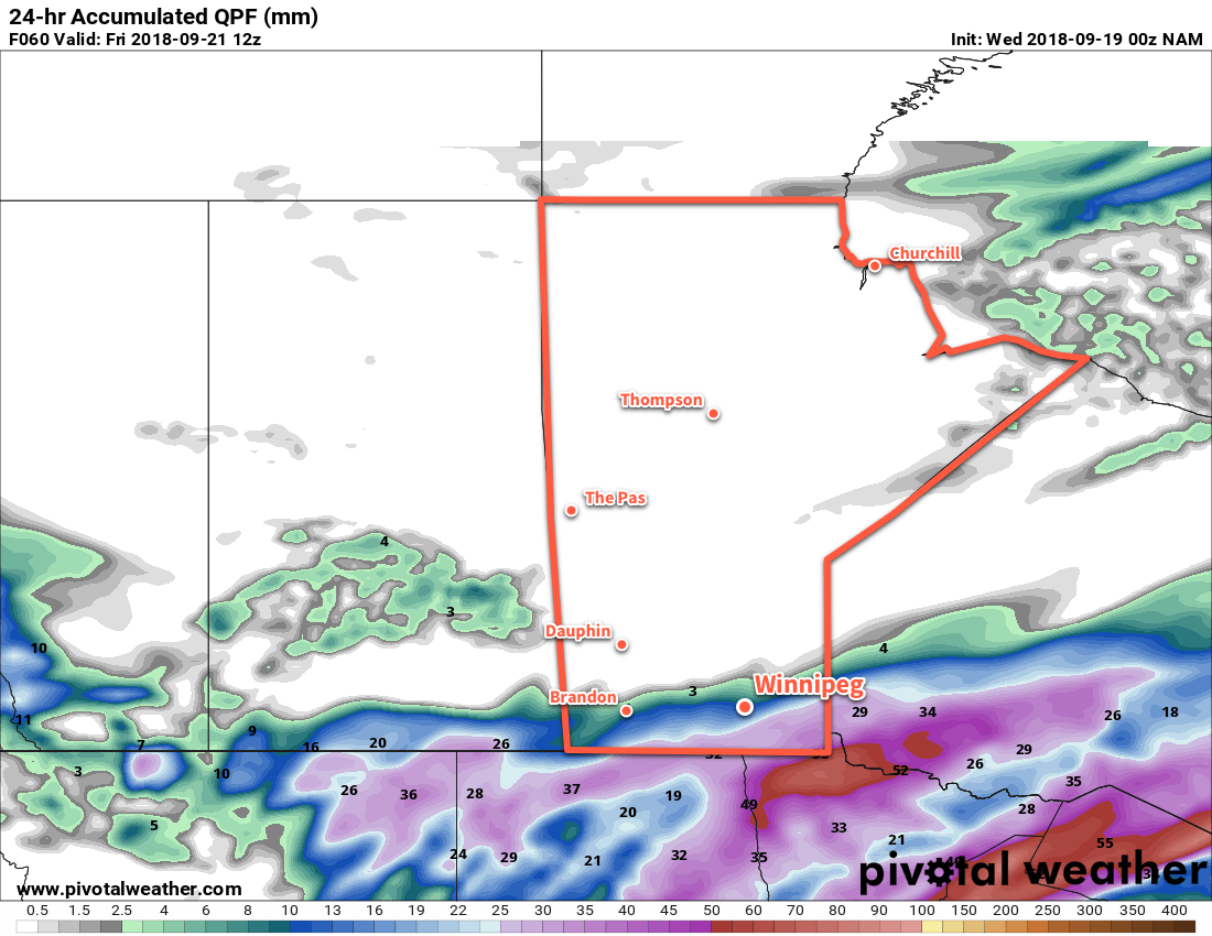
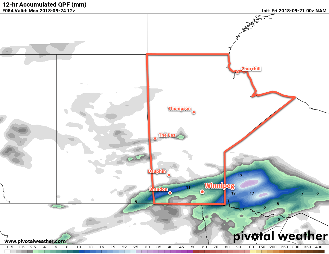
Friday night will see plenty of cloud cover build back into southern Mantioba. On the upside, this cloudy blanket will help prevent temperatures from dropping too much; Winnipeg should see a low near 6°C tonight. A clipper-like disturbance will speed across western Manitoba and the Interlake overnight, bringing a rain swath of 5-10 mm along its track. Further south in Winnipeg, a few showers are possible in the evening. Later in the evening, light rain with lesser accumulations may pass through the region, right through Saturday morning.

Speaking of Saturday it’ll  be a lousy day. Winnipeg will see a well below-seasonal high near 7°C with moderate north-easterly winds near 30 gusting 50 km/h. Skies will remain mostly cloudy through the day.

Winnipeg will see mixed skies on Saturday night. The breaks in the cloud will allow temperatures to cool off. sending overnight lows down to a chilly +2°C. This is close enough to freezing that any areas that see any prolonged clearing through the night will see the risk of patchy frost.

The cloud thickens back up again on Sunday as the next disturbance approaches the region. Winnipeg and the Red River Valley will see the chance for some light, scattered showers through the day, followed by organized rain moving through on Monday night. Wind will be out of the east near 20 km/h as temperatures climb to a high near 7°C.

NAM 12hr. QPF valid 12Z Monday September 24, 2018
More rain is possible on Sunday night as another disturbance moves through the region

Rain is forecast to move through the Red River Valley on Sunday night with temperature remaining steady near 7°C.

Long Range Outlook

Unfortunately, next week won’t start off much better. Plenty of cloud will remain in the region next week with daytime highs continuing well below seasonal values. Ensemble guidance has good confidence that Winnipeg will continue to see below-seasonal daytime highs right through the end of the month.

Winnipeg’s seasonal daytime high is currently 17°C while the seasonal overnight low is 5°C.

Cool Conditions Ahead with Rain Thursday Night

Winnipeg will see below-seasonal temperatures remain in place for the remainder of the week. Rain returns to the region late Thursday, spread northwards by a low pressure system crossing the northern United States.

Winnipeg will see skies clear through the morning today as a ridge of high pressure builds into the region. Unfortunately, this same ridge will also reinforce the seasonably cool temperatures in place over the region. With a light northerly wind, Winnipeg will see a high near 14°C today. This is a few degrees cooler than typically seen around this time of year. With clear skies in place for much of the night, temperatures will dip to a low near +2°C.

There will be a risk of frost with these cool lows, especially further west in the Red River Valley where temperatures may dip a degree or two lower. Further west into southwestern Manitoba will likely see at least patchy frost with widespread lows near 0°C. Cloud cover will begin building in overnight, mitigating some of the frost threat.

Cloud cover will spread across southern Manitoba on Thursday in advance of a low pressure system moving through the northern US. Much of the day will remain dry, but this low will slowly increase winds out of the north to 20 to 30 km/h. Rain will begin spreading out of North Dakota into southern Manitoba by late in the afternoon.

Accumulating rain will mainly be along and south of the Trans-Canada Highway from the Saskatchewan border eastwards across the Red River Valley, and throughout the southeastern corner of the province. General amounts of 10-20 mm are forecast to fall with rapidly diminishing accumulations north of the main band of rain. Embedded convection could result in localized areas where rainfall totals could reach into the 20-40 mm range. This seems more likely closer to the US border.

Rain will spread across southern Mantioba on Thursday night

All that cloud will keep overnight lows near-seasonal; Winnipeg should see temperatures dip to 5°C.

As the disturbance exits the region on Friday, another ridge of high pressure will build in from the northwest. The cloud will break up on Friday morning as the winds gradually diminish. Temperatures in Winnipeg will once again be cool with a high near 15°C.

More cloud cover will push in Friday evening ahead of the next disturbance forecast to move through the region. Winnipeg’s low is forecast to fall to around 5°C on Friday night.

Long Range Outlook

More cloud with a chance of rain will move through on the weekend as a weaker clipper system zips across the southern Prairies. Temperatures will remain cool with daytime highs in the low teens and near-seasonal overnight lows.

Winnipeg’s seasonal daytime high is currently 17°C while the seasonal overnight low is 5°C.

Cooler Temperatures with Variable Cloudiness Ahead

Winnipeg will see below-seasonal temperatures alongside variable cloudiness to start the week as a series of Arctic highs move through the Prairies.

Winnipeg will see mainly cloudy skies today as a weak disturbance moves through the region. The city will see a chance of more drizzle this morning. By midday the potential for drizzle will taper off, leaving Winnipeg with mostly cloudy skies. Winds will remain light through the day with a high near 12°C. The cloud cover should begin to break up overnight as temperatures head to a low near 5°C.

Unstable, saturated low-levels will bring the chance of drizzle to Winnipeg on Monday morning.

Tuesday will bring slightly warmer temperatures, but they will still fall short of seasonal values. Under partly cloudy to mixed skies, the temperature in Winnipeg will climb to a high near 15°C. Like Monday, the northerly winds will remain light. Skies will cloud over Tuesday night with a slight chance of showers as temperatures head to a low near 6°C.

Wednesday will bring mixed to mostly cloudy skies as Winnipeg finds itself between a weak upper-level disturbance to the south an Arctic high moving through central Manitoba. Temperatures will climb up to a high near 14°C with light winds continuing out of the north. Skies will remain mostly cloudy on Wednesday night ahead of the next low pressure system that will impact the region. Temperatures will head to a low near 6°C again.

Long Range Outlook

The second half of the week may to bring a return to unsettled conditions. A potent low pressure system developing over the United States is forecast to push into northern Minnesota on Thursday, spreading an area of rain across southern Manitoba. Early indications suggest that significant accumulations of 15 to 40 mm are possible with this system under its heaviest rain bands. It should move out for the end of the week, but cool temperatures are forecast to remain right through the weekend.

Winnipeg’s seasonal daytime high is currently 18°C while the seasonal overnight low is 6°C.

Cloudy Skies, Seasonal Temperatures, More Thunderstorms?

Plenty more cloud cover lies ahead for Winnipeg this weekend as another warm front lifts northwards into the province and brings another round of showers and thunderstorms.

Winnipeg will see a bit of sunshine today with some breaks in the clouds expected throughout the day. Daytime highs will climb to a near-seasonal 19°C with light winds courtesy a ridge of high pressure moving through. Winnipeg will see a chance of showers later today as a weak upper-level disturbance rolls through. Temperatures will dip to a low near 8°C tonight with mixed skies continuing through the night.

On Saturday, a low pressure system over North Dakota will slowly lift a warm front north into the province. While Winnipeg may see a bit of sunshine in the morning, skies will cloud over through the day. Winds will be out of the northeast at 10 to 20 km/h. The cooler northeast winds will keep highs near-seasonal despite the advancing warm air.

Thunderstorm Threat Returns to Southern Manitoba Saturday Night

On Saturday night, a low pressure system will begin its trek from southwestern North Dakota towards Lake of the Woods. As it lifts northeastwards, elevated convection will once again fire north of the warm front, spreading showers and thunderstorms through a portion of southern Manitoba. This instability will persist into Sunday with the potential for showers and thunderstorms continuing through much of the day.

Given elevated convection 36+ hours out, there’s still a lot of the details that remain unclear. Early indications are that another round of severe thunderstorms will be possible; guidance suggests a fair amount of instability and strong shear to help the elevated convection organize. Right now it looks most likely over the southern Red River Valley into southeastern Manitoba. It’s early, though, and that could easily shift over the coming days. We’ll be keeping an eye on it. Given the extensive cloud cover and proximity of the warm front, Saturday night will remain mild with a low near 14°C in Winnipeg.

Forecast MUCAPE values reveal the substantial instability forecast to develop over southern Mantioba as a warm front lifts north on Saturday night.

The instability continues through Sunday with a chance of showers or thunderstorms for Winnipeg. It won’t be an all-out rainy day and most of the precipitation should end up north of the city. Winds will be out of the northeast at 15-20 km/h for much of the day. As the low passes in the afternoon, winds will shift northerly to 30 gusting 50 km/h. Temperatures should reach a high near 18°C, but much warmer temperatures will be in place just to the southeast on the other side of the warm front where highs near 30°C are possible, so areas closer to the US border, particularly southeast of Winnipeg, will see much warmer highs. Given the large change in temperatures across the front, if its position ends up a bit further north then Winnipeg could see a much warmer high.1

While Winnipeg will see near-seasonal temperatures on Sunday, it may end up being a scorcher over southeastern Manitoba.

The cloud cover will remain as the precipitation moves off to the east on Sunday night. Temperatures will dip to a low near 9°C as cooler air pushes south behind the low.

Long Range Outlook

Monday will bring more cloud to Winnipeg with a slight chance of showers as a weak low pressure system moves through the region. Temperatures will be much cooler with a high in the low to mid-teens. The remainder of the week will bring mixed to cloudy skies and seasonal to slightly below-seasonal temperatures. Another batch of rain looks possible in the second half of the week. After a dry first two thirds of the year, it seems like Winnipeg may finally be beginning to catch up on its precipitation deficit!

Winnipeg’s seasonal daytime high is currently 18°C while the seasonal overnight low is 6°C.

  1. That said, it’s not particularly common for warm air to push further north than expected at this time of year.