Spring Rain Arrives This Weekend

The first widespread rainfall of the season will move into southern Manitoba this weekend.

Winnipeg will wrap up the work week with another seasonably cool, mostly cloudy day. A weak Arctic ridge moving through in the region today will keep temperatures down. The daytime high should be around +4°C, but it might get a couple degrees warmer if more cloud cover burns off a bit earlier than expected this afternoon. The city should see some clearing this evening, but more cloud will begin moving back in overnight. Temperatures will dip to a low near -4°C.

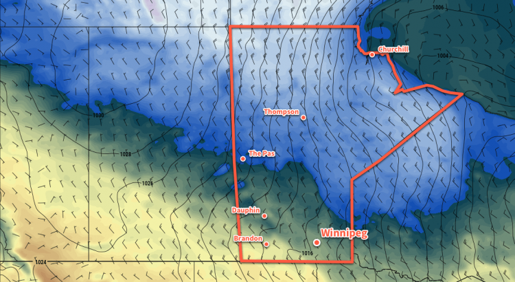
Saturday will see a complicated system developing over the Northern Plains and eastern Prairies. A weak low pressure system will develop over central Alberta on Saturday while a stronger low develops over Nebraska. As the southern low strengthens, the Alberta system will weaken to a broad trough. A broad south-easterly flow will then develop from the warm sector of the southern low into the northern Prairies.

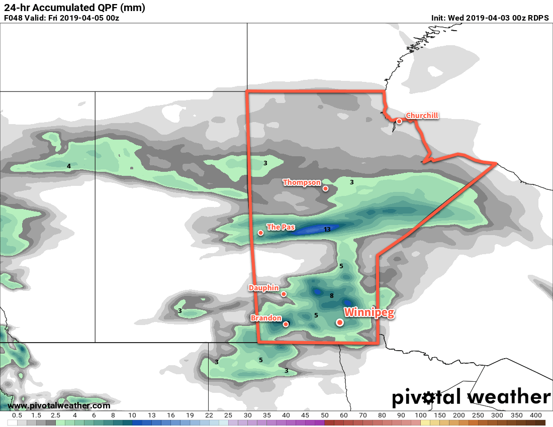
For Winnipeg, this will result in cloudy skies on Saturday seasonal high near 7°C. Northeasterly winds will be in place much of the day at around 20 km/h. On Saturday night, the surface trough will push into southern Manitoba, bringing a broad area of rain into the region. Winnipeg should see some rain begin overnight and persist into Sunday morning. Temperatures will dip to a low near +1°C with light winds.

The Red River Valley is forecast to see over 10 mm of rain Saturday night into Sunday.

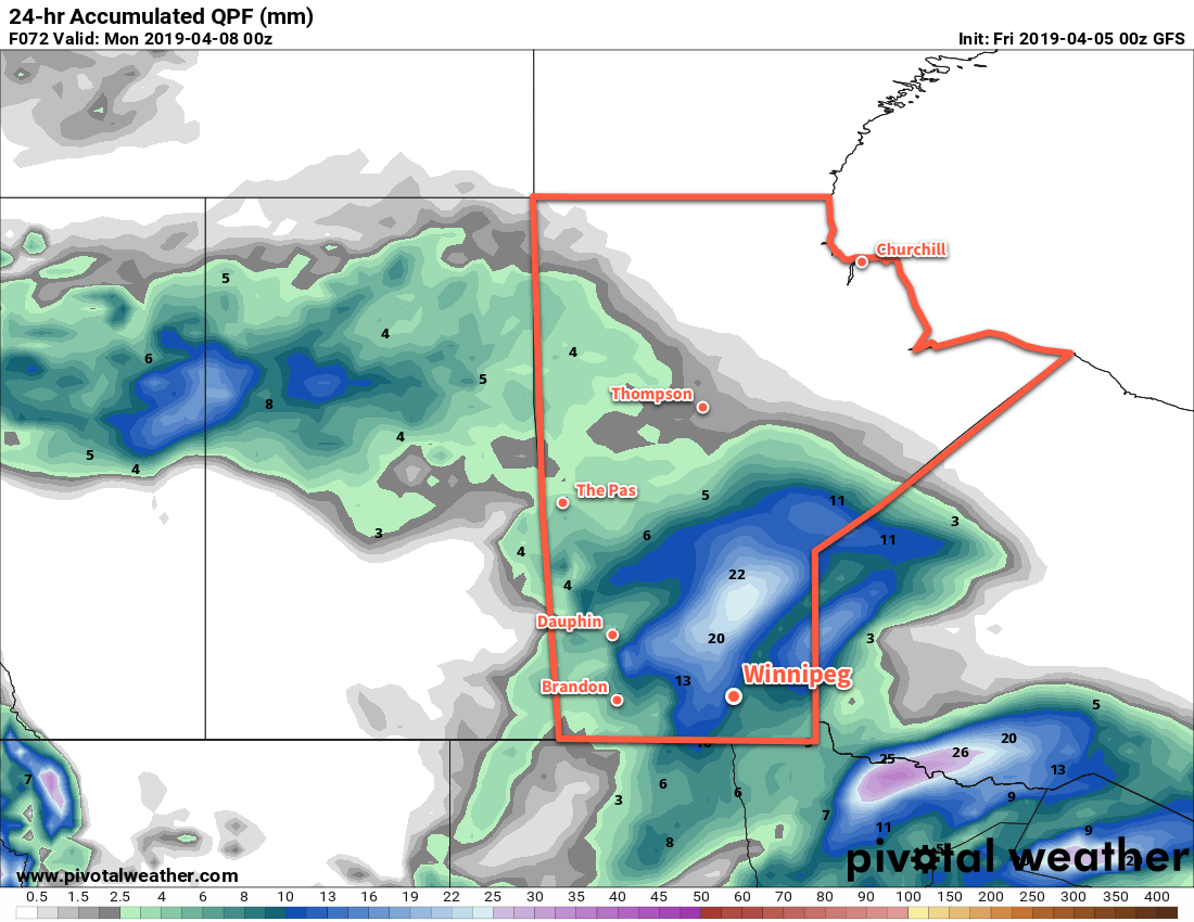
Rain will taper off sometime midday Sunday in Winnipeg. The city is forecast to receive around 10 mm of rain which looks like a reasonable value right now. Once the rain ends, cloudy skies will stick around for the rest of the day. Temperatures will remain seasonal with a high around 6°C. The chance for some rain showers will return Sunday night into Monday morning as temperatures dip to a low near +1°C.

Long Range Outlook

The city will continue to see mixed to mostly cloudy skies of much of the coming week, but temperatures will remain near to above-seasonal. No significant precipitation is forecast through the week.

Today’s seasonal daytime high in Winnipeg is 7°C while the seasonal overnight low is -4°C.

Seasonably Cool Wednesday Turns Unsettled For Thursday

A mix of rain and snow will move through Winnipeg on Thursday, marking the start of an unsettled warm-up for the weekend.

Today will be a sunny but cool day in Winnipeg as a ridge of high pressure moves through. With light winds, temperatures will climb to a high near +1°C. Skies will stay mostly clear tonight with temperatures dropping to a low near -6°C.

Weather returns to the region on Thursday as a warm front moves through ahead of a low pressure system in Saskatchewan. Skies will cloud over early in the day with southerly winds increasing to 40 gusting 60 km/h. By mid- to late-afternoon, a wintery mix of precipitation will work its way across the Red River Valley. The rain/snow will exit the region early in the evening, leaving behind light winds, cloudy skies, and a chance of drizzle. Winnipeg will see a low near 0°C on Thursday night.

Much of southern Manitoba will see some amount of a sloppy wintery mix of precipitation on Thursday.

Skies will start off cloudy on Friday morning with a continued chance of drizzle, then a weak cold front will push through the region. Skies should begin to clear in the afternoon with temperatures reaching a high near 6°C. The reprieve will be short-lived, though as more cloud pushes in overnight ahead of the next disturbance. Temperatures should dip to around -3°C on Friday night.

Long Range Outlook

Winnipeg’s weekend looks mild thanks to a southwesterly flow developing aloft. Unfortunately, that also means rather unsettled conditions with a fair amount of cloud and a couple chances for precipitation. Temperatures will climb into the teens, though, with overnight lows likely remaining above zero. It appears that conditions will gradually settle next week with a return towards seasonal temperatures.

Today’s seasonal daytime high in Winnipeg is 6°C while the seasonal overnight low is -5°C.

Increasing Cloudiness Brings Unsettled Conditions to Winnipeg

Winnipeg will see increasing cloudiness today as it spreads northwards out of the Dakotas. The cloud will continue through the remainder of the week with several chances for wet weather.

A sunny start in Winnipeg today will develop into partly cloudy to mixed skies through the day as a warmer air mass pushes in from the southwest. Fortunately, despite any cloud the temperatures will still climb to an above-seasonal high near 10°C! Winds won’t be too much of a bother, increasing out of the south-southwest into the 20 to 30 km/h range. Winnipeg will continue to see mixed skies tonight with overcast skies developing early Thursday morning. Temperatures should dip to a low near +3°C.

Winnipeg may see some organized light rain on Friday morning, however model confidence in the location of the rain is low.

Thursday and Friday will bring cloudy skies to Winnipeg as several weak upper-level disturbances move through the region. There will be a persistent, background chance for some drizzle or light showers through the region on Thursday and Friday, but the best chance for organized rain showers is on Friday morning. Temperatures will remain near-seasonal with a high of around 9°C on Thursday and near 7°C on Friday. Winds won’t be an issue either day, with light easterlies expected through the period. Temperatures will dip down to around +4°C on Thursday night and near +2°C on Friday night.

Long Range Outlook

Cloudy conditions will persist through Saturday and into Sunday with more chances for some light rain shower activity. Winnipeg may see some sunshine mixed in through the day on Sunday, however the overall trend is for mixed to cloudy conditions to continue right into next week. No major rain systems are on the horizon, but the occasional chance of light showers is forecast to return here and there over the next week.

Overall signals are weak at the moment, but it appears that there is a chance of cooler weather moving in the middle of next week with a return to highs in the low single digits.

Winnipeg’s seasonal daytime high is currently 7°C while the seasonal overnight low is -3°C.

Cooler With A Chance of Showers to End the Work Week

After record-setting heat yesterday, a change is in the weather as unsettled conditions today lead to cooler temperatures for the weekend.

Winnipeg’s sunny skies of yesterday will be replaced by mixed to mostly cloudy skies today. A cold front passed through the region overnight, ushering in northwesterly winds for today that will keep conditions much cooler than yesterday. With breezy northwesterly winds near 30 gusting 50 km/h, Winnipeg should see a high near 8°C today.

A second cold front will sweep through the region late in the day as Arctic air surges southwards behind the low pressure system that brought the mild temperatures to the region yesterday. As the front pushes through, it will bring a chance of showers to the Red River Valley for the late afternoon into the evening. Cooler temperatures will continue to spill southwards through the night as the northwesterly winds continue. There will be a chance for flurries in the lee of the Manitoba Lakes right through the overnight period. Winnipeg will see a low near -3°C under mixed skies.

3km NAM Simulated RADAR Reflectivity with Type valid 00Z Saturday October 20, 2018
Scattered showers will spread across portions of southern Manitoba as a cold front slumps through late Friday afternoon.

Saturday will be a very cool day as an Arctic high moves across the region. Winds will diminish through the morning as temperatures climb towards a high of just +3°C. Skies should be partly cloudy with more organized bands of stratus coming off of the lakes to both the west and east of Winnipeg. Heading into the night, more cloud will move into the region as a warm front pushes across the province. Winnipeg will see a low near -1°C with southerly winds near 20 km/h.

Sunday should bring mainly sunny skies to Winnipeg as the cloud pushes off to the east. With the warm front through, the city should see a more seasonable high of around 10°C with light winds. It’s looking like Sunday will actually be quite a pleasant fall day! Temperatures will head to a low near +1°C on Sunday night with light westerly winds.

Long Range Outlook

Next week looks set to bring closer to seasonal conditions. Daytime highs in the mid- to upper single digits are forecast alongside variably cloudy skies. It also appears that it will remain dry with no notable precipitation in the forecast.

Winnipeg’s seasonal daytime high is currently 9°C while the seasonal overnight low is -1°C.