Mild Weather Arrives in Winnipeg

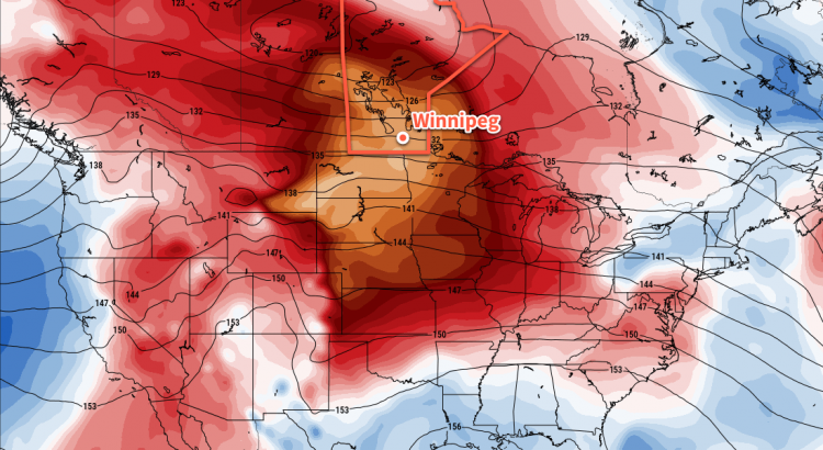
Winnipeg will finally get prolonged relief from the bitter cold as significantly warmer temperatures will be in place for the next 5-7 days.

Winnipeg will likely see the “best all-around” day of the next week today, as clear skies combine with relatively light west-southwest winds of 15-25 km/h and a high near -2°C to make for simply gorgeous January conditions. Cloud over tonight with a good chance for a bit of light snow to move through but no accumulations are expected. Temperatures will dip to a low near -11°C.

Thursday will bring slightly cooler temperatures to Winnipeg with a daytime high near -4°C and light southerly winds. Skies will remain mostly cloudy for the day, so it’ll end up a bit of a sloppier, dreary day particularly when compared to Wednesday’s bright sunny skies. The cloud will thicken up on Thursday night as a low pressure system races eastwards out of northern Alberta. Temperatures will actually rise to around -1°C by Friday morning as that Alberta low pushes warmer air into the region overnight.

Significantly milder air will spread across southern Manitoba on Thursday night

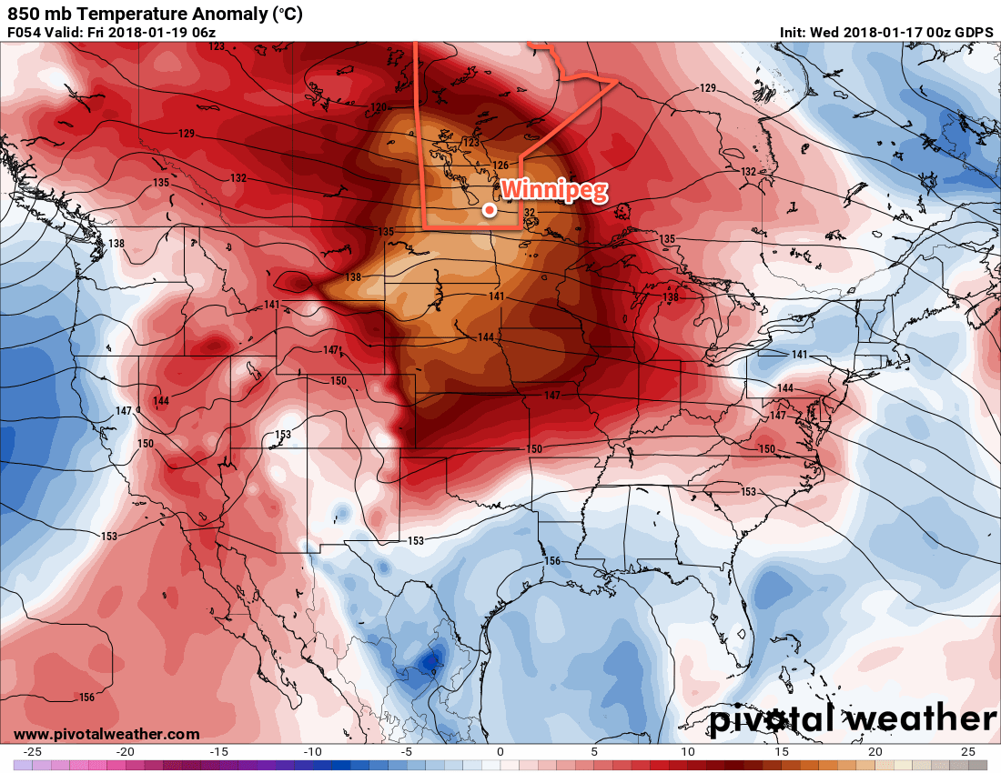
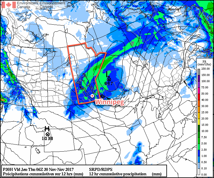
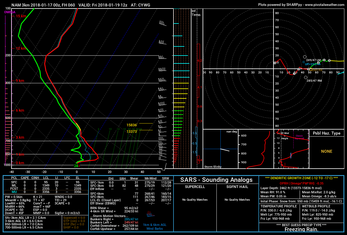
Friday morning may bring a complication to the morning commute: the potential for freezing rain. As the low pressure system passes through the Interlake, it is expected to develop an area of showers over the Red River Valley.1 The biggest uncertainty is when exactly the showers move in, as temperatures should climb above 0°C by mid-morning. With the day starting near -1°C, it’s likely that treated roads won’t have too much trouble if the rain begins before it climbs above freezing, but extra caution should be taken on side streets and bridges.

The forecast sounding for Friday morning shows moisture streaming in above a prominent above-freezing layer with sub-freezing surface temperatures

The chance of showers should taper off by afternoon, and temperatures will climb to a high near +2°C with winds out of the west-southwest at 10 to 20 km/h. Friday night may bring a bit of clearing as temperatures head to a low near -8°C.

Long Range Outlook

The weekend will continue to bring above-seasonal temperatures, but not quite as significantly as during the week. Daytime highs of -5 to -8°C are expected on Saturday and Sunday with overnight lows both nights near -13°C. Plenty of cloud will remain in place for the weekend. Fortunately, winds will remain light so all in all it should be easy to get outside and enjoy some winter activities!

Temperatures are then expected to return to near-seasonal values next week with daytime highs in the -10 to -15°C range and overnight lows approaching -20°C.

Winnipeg’s seasonal daytime high is currently -13°C while the seasonal overnight low is -23°C.

  1. At this point, it looks like the showers will develop along the upper-level jet that will run from southeastern Montana northeastwards into the Red River Valley then arc straight eastwards into Ontario, roughly aligning along the cold front, across the triple point, and down the warm front associated with the Interlake low.

Another Mild and Windy Day Gives Way to More Cloud And Unsettled Conditions

Mild weather will remain in place for Winnipeg and the Red River Valley, but a pair of low pressure systems will bring plenty of cloud, wind, and some wet weather over the next few days. Better to make the best of it, though, as it’s increasingly looking like Winnipeg may plunge into the winter deep freeze by the end of next week!

Today will bring cloudy skies to Winnipeg as a low pressure system moves into the province from Saskatchewan. Ahead of the low, strong southerly winds of 40-50 km/h with gusts up to 60-70 km/h will develop in the Red River Valley. The winds will increase through the morning, peak midday, then begin to subside through the afternoon. Temperatures will climb to a high near +3°C once the winds ease, but by late afternoon the chance for snow will pick up as a trough swings through the Red River Valley. There’s a chance that early on, precipitation may fall as rain showers instead of snow, but with wet bulb temperatures expected to remain below 0°C, it should switch over to snow as soon as it strengthens to any moderate intensity. The snow will taper off late in the evening, leaving behind a soggy mess as much of it melts on contact. Temperatures will then head to a low near -3°C with northwesterly winds 40 gusting to 60 km/h picking up mid-evening and tapering off overnight.

RDPS Forecast 12hr. QPF valid 06Z Thursday November 30, 2017
A large swath of rain showers and snow will spread across southern Manitoba today

Thursday will bring cloudy skies for much of the day, although some sun might be seen late in the day as clouds begin to clear out late in the afternoon. Winds will be light and gradually shift to southerly through the day as temperatures climb to a high near +1°C. As mentioned before, skies will clear out for Thursday night, leaving Winnipeg with starry skies as temperatures head to a low near -5°C with light winds.

Friday will be another mostly cloudy day as overcast skies move back into the region through the morning. Temperatures will climb to a high near +1°C again with continued southerly winds at 10-20 km/h. Another disturbance tracking across the region will bring a mix of rain changing to snow to Winnipeg sometime in the morning and ending by mid-afternoon. W

Temperatures will dip to a low near -5°C under partly cloudy skies on Friday night.

Long Range Outlook

Mild temperatures will continue through the weekend under variable cloudiness, but a large-scale pattern change next week looks to put the wheels in motion towards an outbreak of Arctic air that would plunge much of central and eastern Canada into a period of below-normal temperatures.

GPDS Forecast 850mb Temperature Anomaly valid 12Z Friday December 8, 2017
The GDPS model is one of the growing consensus that well below-normal temperatures will be in place over the region by the end of next week

Models have growing consensus that over the coming week, a strong upper-level ridge will develop, and remain anchored, over British Columbia. In response to that ridge, a deep upper-level trough is expected to develop in response over eastern Canada, bringing a northwesterly flow to the Prairies that would set up the Arctic pipeline, allowing much colder air to spill southwards. With the growing consensus in the models, it seems like it would be prudent to enjoy the mild weather as much as possible…a more traditional Winnipeg winter may be looming on the horizon.

Winnipeg’s seasonal daytime high is currently -6°C while the seasonal overnight low is -15°C.

Shift to Mild Conditions Brings Cloudy and Unsettled Weather

Winnipeg will see a fair amount of cloud alongside some chances for snow or rain over the next few days, but it’s all in service of bringing in an unseasonably warm air mass that will remain in place for the entire week, making above-freezing high temperatures a common site into the weekend!

Today will bring cloudy skies to Winnipeg as a low pressure system passes through central Manitoba. As the warm front pushes through this morning, there will be a chance of some light rain or, if temperatures haven’t climbed above 0°C yet, some freezing rain – wouldn’t that be wonderful for the morning commute. Unfortunately, as of writing this on Sunday evening, there’s still significant disagreement in the models as to whether or not it will happen and any of the typical signals won’t show up until overnight, making it more of a last-minute forecast. If your plans are sensitive to freezing rain, I suggest you check the Environment Canada forecast for Winnipeg which was updated early this morning. After the warm front moves through, temperatures will reach a high near +4°C in the warm sector with calm winds as a trough of low pressure moves through. A few rain showers will roll through later this afternoon then a cold front will swing through, ushering in moderate west-northwest winds of 40 gusting to 60 km/h. These winds will persist through the night as temperatures head to a low near -3°C.

NAM Precipitation Type/Intensity valid 00Z Tuesday November 28, 2017
Most forecast models suggest Winnipeg and area will see showers move through this evening ahead of a cold front

On Tuesday, a ridge of high pressure will work into the province from the west. As it approaches, winds will taper off and skies will become mixed as temperatures remain roughly near -4°C for much of the day. Skies will clear through the afternoon, and as the sun sets the light winds and clear skies will allow temperatures to drop quite quickly to a low near -7°C, but another warm front approaching will quickly move into the region after midnight, spreading cloud and milder air that will raise temperatures close to -2°C by Wednesday morning.

Wednesday will once again be a cloudy day in Winnipeg as yet another low pressure system tracks through central Manitoba. Temperatures will climb to a high near +2°C with breezy southerlies of 20-30 km/h. A trough will move through in the afternoon, bringing a chance of rain or snow with it. Any remaining precipitation will exit the region by late evening, but don’t expect the weather to get too cold: no big cold push seems evident behind this low! Expect a low near -5°C on Wednesday night with skies becoming mixed.

Long Range Outlook

The remainder of the week continues to look mild, with daytime highs in the 0 to +3°C range and overnight lows near in the -4 to -8°C range. Skies will be variably cloudy, and chances for rain or snow seem minimized until the end of the weekend into the beginning of next week, where a few more systems may move through that bring some precipitation to the region. Enjoy the unseasonal end of November warmth! Perhaps an earned break after the record cold that started off the month!1

Winnipeg’s seasonal daytime high is currently -6°C while the seasonal overnight low is -14°C.

  1. November 9th set new daily record for minimum daily maximum and minimum daily minimum temperatures. Yikes!

Generally Mild Conditions Ahead

While today will start off with some showers as cold fronts usher the above-freezing temperatures out of the region, conditions will remain generally mild with near-seasonal to above-seasonal temperatures expected over the coming week.

Winnipeg will see a mild start to the day with temperatures near +3°C, but that warmth will be short-lived. A cold front sweeping through early this morning will bring a band of showers across southern Manitoba. This front will usher in breezy westerly winds near 30 km/h with gusts up to around 50 km/h. The showers should taper off behind the front, but a second cold front will then drop southwards in the afternoon, bringing with it flurries as the winds shift northwesterly and temperatures drop further to around -1°C by the evening. The flurries will taper off in the evening as the breaks up a bit, leaving mixed skies for the night. Winds will taper off as temperatures drop to a low near -9°C.

An area of showers will move across southern Manitoba early this morning

Saturday will bring light winds as a ridge of high pressure moves across the Red River Valley, likely with a bit of morning sunshine. Cloud will build back eastwards into Winnipeg in the afternoon though, as the front that dipped southwards through the Red River Valley rebounds to the west and begins pushing back into the Red River Valley again. No snow or rain is expected in the Red River Valley; any precipitation will be further north, close to a low pressure system crossing through central Manitoba. Temperatures will climb towards a high near -2°C as the cloud moves into the region, and winds will pick up out of the south to around 20 km/h. Expect skies to remain mostly cloudy on Saturday night with temperatures remaining near -2 or -1°C for much of the evening, then dropping to a low near -5°C overnight as a weak cold front slumps through, shifting winds northwesterly and bringing in cooler air.

Sunday will bring mostly cloudy skies to the region yet again as temperatures remain steady near -4°C for much of the day. Another ridge of high pressure will be moving across the province, so winds will remain light throughout the day. Skies will remain cloudy on Sunday night as another warm front approaches from the west. Temperatures will climb towards -1°C by Monday morning with increasing southerly winds to 20 to 30 km/h.

Long Range Outlook

Looking ahead, Monday looks mild but may bring rain or snow to the region as another significant low pressure system crosses through the central Prairies. Afterwards, a zonal flow persists over the Prairies bringing multiple disturbances through the week that will bring occasional chances for flurries. Temperatures will remain near-seasonal to above normal, with relatively mild temperatures expected to remain in place for much of next week!

Winnipeg’s seasonal daytime high is currently -5°C while the seasonal overnight low is -13°C.