A Mix of Spring Weather Ahead

Winnipeg will see temperatures return to near-seasonal values to start a week that will see temperatures go on a bit of a roller coaster.

Winnipeg will see a whole bunch of sunshine today with temperatures climbing to a high near 14°C. It will be a bit breezy with northwesterly winds of 20 to 30 km/h in place behind a cold front that passed through late yesterday. Some cloud cover will begin working into the region late in the day and bring cloudier skies for much of the night. The cloud should clear out early Tuesday morning as temperatures head to a low near 0°C.

Temperatures in the Red River Valley will be slightly cooler on Tuesday as an area of high pressure moves through, but warmer weather is quickly spreading eastwards across the Prairies behind it.

Tuesday will bring sunny skies to southern Manitoba as a ridge of high pressure moves through. With light winds and a high near 11°C, Winnipeg will see a slightly cooler-than-seasonal, but overall pleasant, spring day. Temperatures will dip to a low near +3°C on Tuesday night.

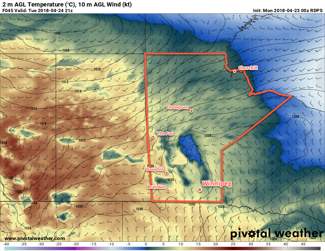
A low pressure system tracking through the northern Prairies on Wednesday will bring warm and windy weather back to the region. Temperatures will climb to a high near 19°C, but south to southwesterly winds of 40 to 50 km/h will develop in the Red River Valley.

These strong winds and continued dry weather1 will produce potentially dangerous fire conditions in the valley.

Strong winds will spread into the Red RIver Valley on Wednesday afternoon.

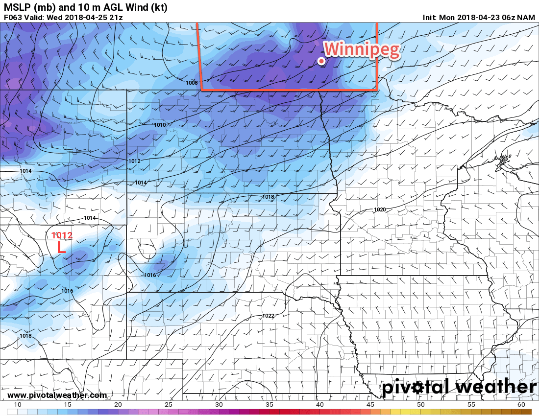
Skies will cloud over through the day followed by winds easing in the evening. After a few hours of calm, a cold front will push southwards through the Red River Valley, bringing a slight chance of showers to the region as it moves through followed by breezy northerly winds of 30 to 40 km/h. Temperatures will head towards a low near +4°C.

Long Range Outlook

Temperatures will continue on a roller coaster through the remainder of the work week. After Wednesday’s mild conditions, Thursday will bring significantly cooler temperatures to the region with highs falling back to seasonal to below-seasonal values. The fall is short, though, with temperatures rebounding back towards the 20°C mark through Friday and Saturday. At this point, the weekend is looking beautiful with temperatures in the upper teens or low 20’s and variable cloudiness.

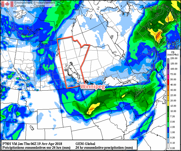
What Winnipeg won’t see much of, though, is rain. Chances for precipitation continue to look minimal. At this point, it looks like the next chance for accumulating rainfall will be early next week; weather models are forecasting a rather complicated storm system pushing into southern Manitoba from Montana on Monday through Wednesday.

For now, enjoy the warmth and sunshine!

Winnipeg’s seasonal daytime high is currently 13°C while the seasonal overnight low is +1°C.

  1. Relative humidity values on Wednesday are forecast to hover around 20%.

Spring-Like Weather Finally Arrives

Temperatures are finally beginning to move back towards seasonal with 2018’s warmest temperatures thus far on the way!

Finally. The relentless chill that has remained over the province for a significant portion of March and April is giving way! Milder temperatures will build back into the region this week, sending daytime highs to the warmest values seen so far in 2018. While temperatures will still remain slightly below-normal, it will be a huge improvement over the days earlier this month that were 10 to 15°C colder than seasonal values!

It all begins today with a ridge of high pressure bringing sunny skies and light winds to Winnipeg. Temperatures will climb to a high near 7°C. This is still below the seasonal +10 to +11°C, but still significantly better than seen over the past weeks. Temperatures will dip to a low near -5°C tonight under clear skies.

Tuesday will bring partly cloudy skies to Winnipeg. The Red River Valley will be on the eastern edge of a system lifting into Northern Manitoba spreads overcast skies through parts of Saskatchewan and western Manitoba. Winds will be a bit more noticeable than Monday out of the east-southeast at 15 to 25 km/h. Temperatures will be quite mild, though, with a near-seasonal high of 10°C. Skies will cloud up Tuesday night as temperatures head to a low near 0°C.

RDPS 24hr. QPF valid 06Z Thrusday April 19, 2018
Some light showers will try to work into the Red River Valley Wednesday afternoon and evening.

Wednesday will bring cloudy skies to Winnipeg & the Red River Valley as systems pass by to the north and south of the region. There may be a slight chance for some showers later in the afternoon into the evening, but a light northeasterly wind will continue to push dry air into the Red River Valley and do its best to keep things at bay.1 Temperatures will climb to a high near 7°C again, then head to a low near 0°C on Wednesday night under cloudy skies.

Long Range Outlook

Long-range outlooks show the potential for some showers or snow on Thursday morning, then clearing working into Winnipeg later in the day. After that, it’s a trend towards seasonal to above-seasonal temperatures with highs in the mid- to upper-teens possible by the weekend!

Winnipeg’s seasonal daytime high is currently 11°C while the seasonal overnight low is -1°C.

  1. This dry air often spreads underneath precipitation, evaporating it either partially or fully before it reaches the ground.

Mild Weather Arrives in Winnipeg

Winnipeg will finally get prolonged relief from the bitter cold as significantly warmer temperatures will be in place for the next 5-7 days.

Winnipeg will likely see the “best all-around” day of the next week today, as clear skies combine with relatively light west-southwest winds of 15-25 km/h and a high near -2°C to make for simply gorgeous January conditions. Cloud over tonight with a good chance for a bit of light snow to move through but no accumulations are expected. Temperatures will dip to a low near -11°C.

Thursday will bring slightly cooler temperatures to Winnipeg with a daytime high near -4°C and light southerly winds. Skies will remain mostly cloudy for the day, so it’ll end up a bit of a sloppier, dreary day particularly when compared to Wednesday’s bright sunny skies. The cloud will thicken up on Thursday night as a low pressure system races eastwards out of northern Alberta. Temperatures will actually rise to around -1°C by Friday morning as that Alberta low pushes warmer air into the region overnight.

Significantly milder air will spread across southern Manitoba on Thursday night

Friday morning may bring a complication to the morning commute: the potential for freezing rain. As the low pressure system passes through the Interlake, it is expected to develop an area of showers over the Red River Valley.1 The biggest uncertainty is when exactly the showers move in, as temperatures should climb above 0°C by mid-morning. With the day starting near -1°C, it’s likely that treated roads won’t have too much trouble if the rain begins before it climbs above freezing, but extra caution should be taken on side streets and bridges.

The forecast sounding for Friday morning shows moisture streaming in above a prominent above-freezing layer with sub-freezing surface temperatures

The chance of showers should taper off by afternoon, and temperatures will climb to a high near +2°C with winds out of the west-southwest at 10 to 20 km/h. Friday night may bring a bit of clearing as temperatures head to a low near -8°C.

Long Range Outlook

The weekend will continue to bring above-seasonal temperatures, but not quite as significantly as during the week. Daytime highs of -5 to -8°C are expected on Saturday and Sunday with overnight lows both nights near -13°C. Plenty of cloud will remain in place for the weekend. Fortunately, winds will remain light so all in all it should be easy to get outside and enjoy some winter activities!

Temperatures are then expected to return to near-seasonal values next week with daytime highs in the -10 to -15°C range and overnight lows approaching -20°C.

Winnipeg’s seasonal daytime high is currently -13°C while the seasonal overnight low is -23°C.

  1. At this point, it looks like the showers will develop along the upper-level jet that will run from southeastern Montana northeastwards into the Red River Valley then arc straight eastwards into Ontario, roughly aligning along the cold front, across the triple point, and down the warm front associated with the Interlake low.

Another Mild and Windy Day Gives Way to More Cloud And Unsettled Conditions

Mild weather will remain in place for Winnipeg and the Red River Valley, but a pair of low pressure systems will bring plenty of cloud, wind, and some wet weather over the next few days. Better to make the best of it, though, as it’s increasingly looking like Winnipeg may plunge into the winter deep freeze by the end of next week!

Today will bring cloudy skies to Winnipeg as a low pressure system moves into the province from Saskatchewan. Ahead of the low, strong southerly winds of 40-50 km/h with gusts up to 60-70 km/h will develop in the Red River Valley. The winds will increase through the morning, peak midday, then begin to subside through the afternoon. Temperatures will climb to a high near +3°C once the winds ease, but by late afternoon the chance for snow will pick up as a trough swings through the Red River Valley. There’s a chance that early on, precipitation may fall as rain showers instead of snow, but with wet bulb temperatures expected to remain below 0°C, it should switch over to snow as soon as it strengthens to any moderate intensity. The snow will taper off late in the evening, leaving behind a soggy mess as much of it melts on contact. Temperatures will then head to a low near -3°C with northwesterly winds 40 gusting to 60 km/h picking up mid-evening and tapering off overnight.

RDPS Forecast 12hr. QPF valid 06Z Thursday November 30, 2017
A large swath of rain showers and snow will spread across southern Manitoba today

Thursday will bring cloudy skies for much of the day, although some sun might be seen late in the day as clouds begin to clear out late in the afternoon. Winds will be light and gradually shift to southerly through the day as temperatures climb to a high near +1°C. As mentioned before, skies will clear out for Thursday night, leaving Winnipeg with starry skies as temperatures head to a low near -5°C with light winds.

Friday will be another mostly cloudy day as overcast skies move back into the region through the morning. Temperatures will climb to a high near +1°C again with continued southerly winds at 10-20 km/h. Another disturbance tracking across the region will bring a mix of rain changing to snow to Winnipeg sometime in the morning and ending by mid-afternoon. W

Temperatures will dip to a low near -5°C under partly cloudy skies on Friday night.

Long Range Outlook

Mild temperatures will continue through the weekend under variable cloudiness, but a large-scale pattern change next week looks to put the wheels in motion towards an outbreak of Arctic air that would plunge much of central and eastern Canada into a period of below-normal temperatures.

GPDS Forecast 850mb Temperature Anomaly valid 12Z Friday December 8, 2017
The GDPS model is one of the growing consensus that well below-normal temperatures will be in place over the region by the end of next week

Models have growing consensus that over the coming week, a strong upper-level ridge will develop, and remain anchored, over British Columbia. In response to that ridge, a deep upper-level trough is expected to develop in response over eastern Canada, bringing a northwesterly flow to the Prairies that would set up the Arctic pipeline, allowing much colder air to spill southwards. With the growing consensus in the models, it seems like it would be prudent to enjoy the mild weather as much as possible…a more traditional Winnipeg winter may be looming on the horizon.

Winnipeg’s seasonal daytime high is currently -6°C while the seasonal overnight low is -15°C.