One More Day of Warmth Before A Big Cool Down

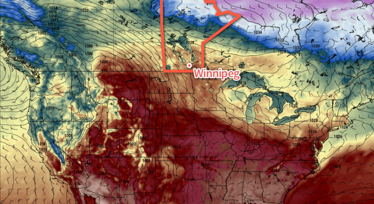
Winnipeg and the Red River Valley will see mild temperatures today, but a sharp cold front will sweep through the early Saturday, bringing unsettled conditions and much cooler temperatures.

A southwesterly flow aloft will draw mild air into the Red River Valley today, eventually sending daytime highs into the mid-teens this afternoon. Before that, however, there will likely be fog patches throughout much of Southern Manitoba. Areas that see fog will likely see some cloudier skies through the morning as the fog lifts, but it should subsequently burn off leaving much of the region under sunny skies. Winds will also be light, so all in all it should be a beautiful day.

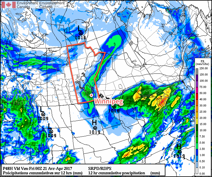
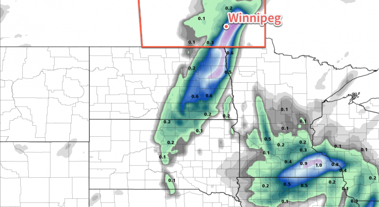
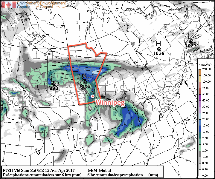
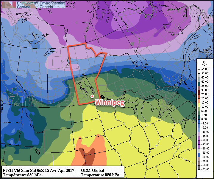
Change is afoot, though. Cloud will move in overnight as a cold front slumps southwards through the province. It will move through very early on Saturday morning, ushering in northerly winds to around 30 gusting 50 km/h and sending temperatures to a low near +2°C. As the front moves through in the morning, it will support an area of precipitation that will begin as rain, but possibly change over to snow mid-morning.

The GDPS is forecasting a swath of 2-5 mm of precipitation across southern Manitoba on Saturday.

The precipitation will end midday as winds begin to ease and temperatures climb to a high near 6°C. There’s a decent chance that the cloud cover will break up a bit in the afternoon let the sun shine through. The wind will diminish on Saturday evening as the temperature drops to a low near -2°C with some cloud cover beginning to move in.

Sunday will bring mixed skies to the region as Saturday’s disturbance departs and the next one develops in Alberta. A reprieve from precipitation, temperatures will climb to a high near 6 or 7°C with light easterly winds. Cloud coverage will increase in the evening as the next system approaches, bringing with it a chance of showers for Sunday night. Temperatures will drop down to a low near 0°C.

Long Range

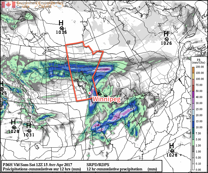
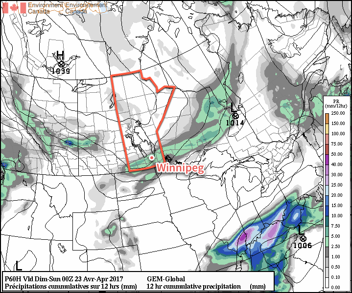
The start of next week will bring more unsettled weather as a major storm system tracks near the American border. Uncertainty exists on the track of the low, and with a fairly sharp boundary to its precipitation, that leads to a wide range of potential precipitation amounts.

The GDPS clips Winnipeg with a major system that tracks along the American border early next week.

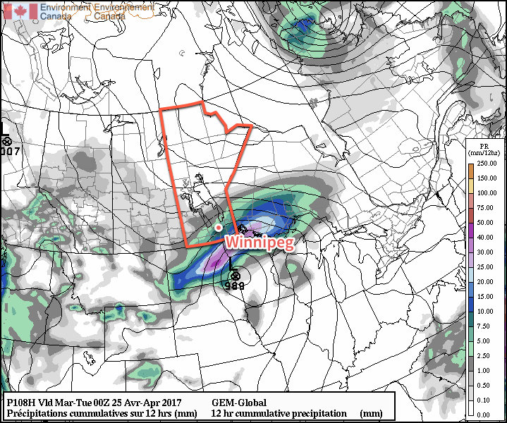
We’ll have updates closer to the event on what exactly we can expect from this system.

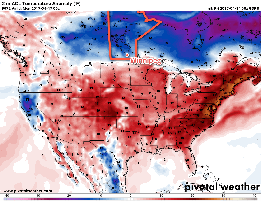
In the wake of that low, Winnipeg and the Red River Valley will see a stretch of calm weather with below-normal temperatures until the end of the week, when another system may impact the region and bring more rain and/or snow to the province.

Winnipeg’s seasonal daytime high is currently 13°C while the seasonal overnight low is 0°C.

Spring Warmth Returns Alongside Showers

After a brief cool-down that followed a wet end to the weekend, spring-like weather will return as mild temperatures return alongside some unsettled weather.

Temperatures are on their way back to near-seasonal today as daytime highs climb to around 12-15°C across the Red River Valley under fairly sunny skies for much of the day. There will be increasing cloud, particularly through the second half of the afternoon and early evening, spreading into the Red River Valley ahead of a low pressure system moving towards Manitoba. Winds will be pleasantly light out of the southeast. Expect temperatures to drop to a low near 4°C tonight under mostly cloudy skies.

On Thursday, a low pressure system tracking across the province will result in cloudy skies for Winnipeg showers developing through the Red River Valley beginning midday. Rainfall amounts look fairly low at just a couple mm, however higher amounts are possible in any heavier showers that might develop. Temperatures will be a bit cooler than Wednesday with highs near 11°C. Some clearing should work into the region on Thursday night as temperatures dip to a low near +2°C.

Showers are likely across the Red River Valley on Thursday

Friday will bring a return to the nice weather with clearing skies and a high near 15°C. A cold front will sweep through the region overnight into early Saturday morning, bringing more cloud into the region alongside some northerly winds. Temperatures will dip to around 3°C.

Long Range

Saturday will be fairly cloudy with a chance of showers through the first half of the day as the cold front clears the region. Temperatures will see a return to below-normal with highs topping out in the mid-single digits. Winnipeg will likely see sub-zero lows once again on Saturday night.

Sunday will bring more cloud back into the region through the day as another disturbance approaches the region. Temperatures will remain cool with highs in the mid- to upper-single digits. More showers are possible, however whether or not Winnipeg will see them depends on the exact track the disturbance takes.

Winnipeg’s seasonal daytime high is currently 12°C while the seasonal overnight low is 0°C.

Unsettled Slide Back to Chilly Conditions for the Easter Weekend

Temperatures will fall off a cliff this weekend from nearly 20°C today to barely above freezing by Sunday as a surge of cold air plows southwards in the wake of a winter storm moving across the central and northern Prairies. This push of colder air will also bring unsettled conditions to Winnipeg & the Red River Valley, with several chances for rain and even a slight chance of flurries towards the end of the weekend.

Winnipeg will see warm and windy weather today as a low pressure system tracking through the central & northern Prairies moves into eastern Saskatchewan. A warm front associated with this system will move through this morning, bringing a slight chance of showers to the region. Temperatures will then climb to a high near 18°C with strong southerly winds increasing to 40 gusting 60 km/h. A cold front will push eastwards into the Red River Valley this afternoon, triggering the development of a line of showers that will move through the valley late in the afternoon into the evening. Along with the rain, there will be a slight chance of an isolated thunderstorm or two along this line of showers.

Portions of the Red River Valley could potentially see over 25mm of rain in the [thunder]showers that move through Friday evening

By 10 or 11PM, the rain should be moving off east of the Red River Valley, and Winnipeg will head towards a low near 6°C with gradual clearing and diminishing winds.

Saturday will actually be a relatively nice day for much of the day. The Red River Valley will be nestled between Friday’s cold front to the east and a second cold front approaching from the north. That said, temperatures will climb to a high near 13 or 14°C with fairly light winds and variable cloudiness. A second disturbance will move into the region late in the afternoon, dragging another cold front southwards into the Red River Valley that will bring another wave of showers to Winnipeg & the Red River Valley. These showers will gradually taper off overnight, but temperatures will be dipping down to a low near +1°C, and those rain showers may change over to flurries in the second half of the night.

Temperatures will be stuck well below-normal (blue) across southern Manitoba on Sunday,

Sunday will be a rather unpleasant day as moderate northerly winds keep the temperature pinned near the freezing mark. Skies will remain cloudy through the day with a chance of flurries. Temperatures will dip down to around -4°C on Sunday night under mostly cloudy skies.

Long Range

Temperatures will slowly rebound towards seasonal through the first few days of next week. Winnipeg may see another chance for showers or flurries on Tuesday, but then things begin to settle down for the second half of the week.

Winnipeg’s seasonal daytime high is currently 10°C while the seasonal overnight low is -2°C.

Major Low Brings Mild Weather

Winnipeg’s temperature will be climbing well above-seasonal through the second half of this week as a major low pressure system develops over the central Prairies, drawing mild air northwards out of the United States. While southern Manitoba will avoid the brunt of this system, it will also bring some gusty winds and a good chance of rain to round out the work week.

Today will be a very pleasant day in Winnipeg as a ridge of high pressure brings mainly sunny skies to the region and temperatures climb to a high near 15°C. Winds will be light out of the east to northeast, making for a wonderful day to get outside. Temperatures will dip down to a low near +1°C under partly cloudy skies overnight.

Thursday will bring even warmer temperatures to the region with highs climbing into the upper teens under partly cloudy skies. A major low pressure system will be organizing over the western Prairies, which will begin to increase winds out of the south over Manitoba. In Winnipeg & the Red River Valley, expect winds to pick up out of the southeast to 20-30 km/h by the end of the day. Temperatures will dip to a low near 8°C on Thursday night under partly cloudy skies. Winds will continue to increase through the night, reaching 30 to 40 km/h by Friday morning.

Much of Manitoba will see precipitation on Saturday with rain in the south changing to significant snow over the north.

Friday will be an active day as the low pressure system heads across the central Prairies and its cold front pushes eastwards across the Red River Valley. Ahead of the front, temperatures will be mild with highs reaching the mid- to upper-teens, but the winds will be quite strong out of the south at around 40 gusting 60 km/h. Cloud will increase through the day as the cold front approaches.

The cold front will push into the Red River Valley in the afternoon, supporting a developing area of showers as it does so. Indications at this point are that the showers could be fairly heavy with a slight chance of some thunderstorms embedded within.

Once the front passes through, winds will die down and skies will clear as temperatures head to a low near 5°C.

Long Range

The weekend looks to be a bit of a mixed bag. Saturday will be pleasant with near-seasonal temperatures and partly cloudy skies. Winds will be out of the west-northwest to around 20 km/h.

Things change on Saturday night as a second cold front moves through the region, ushering in Arctic air that will send temperatures well below seasonal and bring a chance of flurries back to the region.

Once the cold front moves through on Friday evening, cooler air will be ushered into the region throughout Saturday, followed by a second cold front on Saturday night.

Sunday will likely have mainly cloudy skies as temperatures drop to around 0°C midday and remain there. Sunday night will be seasonably cool as skies clear out and temperatures dip to a low in the -3 to -5°C range.

Winnipeg’s seasonal daytime high is currently 9°C while the seasonal overnight low is -2°C.