After a nice weekend, we’re in for a nasty work-week. More rain and chilly temperatures are on the way.
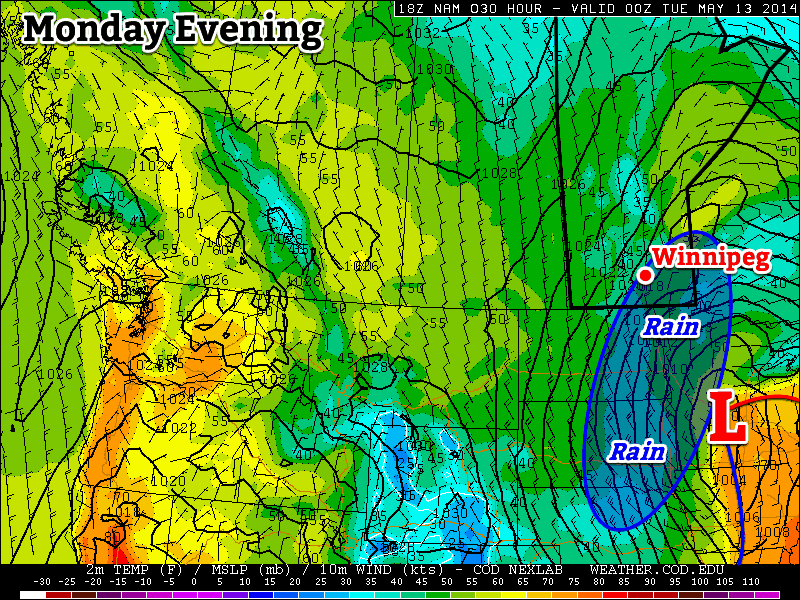
Rain is expected in south-eastern Manitoba on Monday
Monday
Monday
9°C / 5°C
Rain
Today will see rainy weather return, or continue, in southern Manitoba, depending on where you live. Western sections of the province should remain mostly dry, but south-eastern sections will be getting wet, as another strong weather system moves up from the south. Rainfall accumulations of 10-20mm are expected in Winnipeg with 15-25mm in areas south-east of the city, including Steinbach. Locally higher amounts are possible in the south-east corner of Manitoba where heavier rain bands will likely develop. The rain will be accompanied by a strong northerly wind, just adding to the misery!
Tuesday
Tuesday
9°C / -1°C
Mix of Sun and Cloud. Chance of Showers.
There may be some lingering rain showers on Tuesday morning in south-eastern Manitoba, and some more pop-up showers in the afternoon, but generally speaking Tuesday will be a dry day. It will also be a fairly crummy day, with a cool airmass of Arctic origins surging southward into the province. High temperatures aren’t likely to crack the double digits in most areas.
Wednesday
Wednesday
8°C / -2°C
Mix of Sun and Cloud. Chance of Showers.
Wednesday will see a continuation of Tuesday’s nasty, cool conditions, with even colder Arctic air surging southward. Once again, temperatures are not expected to reach double-digits, except for maybe far western sections of southern Manitoba. Pop-up showers may develop in the afternoon, just to cap things off!
Long Range
We should see temperatures return to near normal values by the end of the week into the weekend, however no above-normal weather is in store for the foreseeable future.
There will be only a couple days of sun before the threat for rain returns to the Red River Valley.
After a few unsettled days across Southern Manitoba which, depending on where you were, brought anywhere from no rain to upwards of 15-25mm, the weather is set to offer refuge from the gloom in the form of sunshine and perhaps the warmest temperatures we’ve seen all year. Unfortunately, the pleasantries will be cut short when another complicated weather set-up involving a large cut-off upper low and multiple impulses travelling northeastwards out of the United States redevelops.
Friday
Friday
15°C / 5°C
Mainly sunny.
Today will be a pleasant day with mainly sunny skies and winds out of the northwest at around 20km/h. The temperature should reach a high around 15 or 16°C, which will likely be the warmest day in Winnipeg since we hit 15.1°C on April 23rd. Unfortunately, this will still be 2-3°C below our seasonal normal.
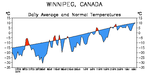
The normal average temperature and departure from it over the last 90 days in Winnipeg.
Despite the temperatures warming up slowly, the fact that we’ve spent such an unbelievable amount of time with temperatures below normal is what is driving many in Winnipeg to dream of warmer climes. Even last year, which had the latest snowpack melt on record[1] had already seen temperatures as high as 26°C by this point.
Unfortunately, I don’t have much good news in that department.
Saturday
Saturday
18°C / 7°C
Increasing cloudiness late in the day.
Saturday will be the nicest day of the year so far, hands down. Skies will be mostly sunny until the cloud shield associated with the next low pressure system begins creeping into the region in afternoon or evening. Winds will be out of the south at around 20-30km/h and the temperature will skyrocket to take the top spot of 2014 so far…at a seasonal 18-19°C![2].
Saturday night will be mainly cloudy with a chance for showers pushing into the southern Red River Valley overnight. The temperature will drop to around 7°C.
Sunday
Sunday
12°C / 3°C
Cloudy. Periods of rain likely.
Sunday will bring a return to cooler, wetter weather as the weather pattern shifts back into a more unsettled regime. It’s a bit early to get too specific, but it seems likely that some light rain is likely as a low pressure system meanders into the Red River Vally from southwestern Manitoba. The high will be close to 12°C and the low will dip down to 2-3°C.
In 2013, the snow pack did not reach a trace amount until April 27th in Winnipeg. ↩
A couple more days of unsettled weather will give way to some of the warmest temperatures of the year.
The main weather story will be gradual improvement as the week progresses. Currently we’re under the influence of a broad trough of low pressure that has brought scattered showers to the Red River Valley over the past couple days.
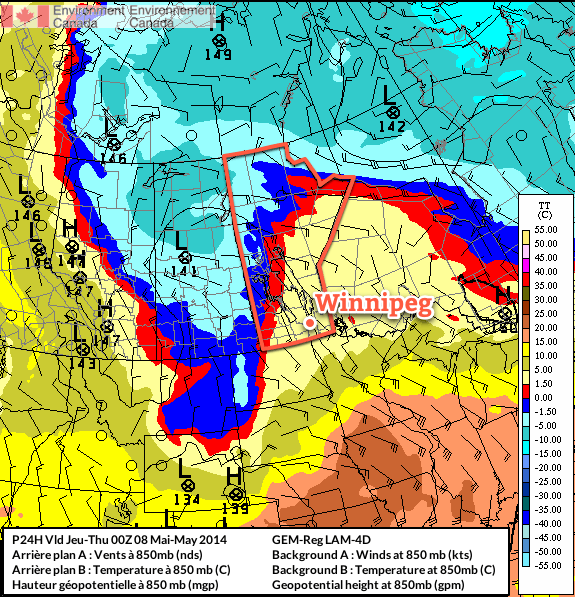
A complicated, high-amplitude flow is developing over the eastern Prairies.
Multiple bands of precipitation will be in place over Southern Manitoba today thanks to multiple disturbances and a fair amount of instability. As the upper-level flow finally organizes itself, a Colorado Low eject northeastwards on Thursday bringing potentially significant rainfall to the Red River Valley and Southeastern Manitoba. The unsettled weather will linger through Thursday night but then a weak ridge of high pressure will begin building in from the west, bringing more settled weather with relatively warm temperatures, especially compared to what we’ve been suffering through so far this spring.
Wednesday
12°C / 6°C
Mainly cloudy. Occasional showers likely.
Thursday
12°C / 4°C
Showers, possibly heavy at times. 5-15mm.
Friday
15°C / 5°C
Clearing.
Today
Today will bring mainly cloudy skies to the Red River Valley as a large low pressure complex stretching from Northern Saskatchewan to Colorado slowly begins organizing itself. More organized showers will fall through much of the day west of the Red River Valley through southwest regions and the Parkland with total accumulations around 5-10mm, but here in the valley we will likely only see scraps of elevated convective showers occasionally moving over the area.
I say likely since there is pretty high uncertainty in exactly how this system will evolve today. The band of showers to our west will slowly creep eastwards towards the RRV through the day and likely push into the western Red River Valley this afternoon. There’s a chance that it will continue pushing eastwards, and if that’s the case then we might see some more organized precipitation later in the afternoon into the evening. There’s also a very outside chance that this whole thing bumps eastwards mid-morning and we’re the ones stuck under the showers for the day.
Complicating matters will be a secondary band of precipitation that will develop this afternoon and lift northwards out of North Dakota and Minnesota. It’s currently forecast to just clip SE Manitoba, but if the upper level trough tilts a bit more, which it has been doing more than the models have been forecasting for 2 days now, that band of rain could end up inside the Red River Valley.
As a third complicating factor, there seems to be fairly unstable mid-levels over most of Southern Manitoba, so even if the precipitation stays to our west and east, there will still be a chance for some light showers zipping across the valley.
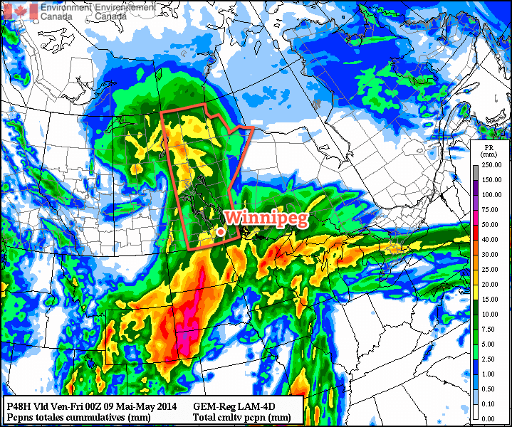
Total precipitation by Thursday evening from the RDPS. The question is will it even be close to right?
It’s a very complicated setup; most models agree that there will be rain on the western and eastern fringes of the Red River Valley with little in between[1], however slight variations in the actual positions of systems could change things quite dramatically. For that reason I’m say that there’s a good chance we’ll see occasional showers today. We may see more, we may see less, but this is a situation where trying to be any more specific than that will likely be a futile effort.
What is a little more certain is that we’ll see a high near 12°C today with light southeasterly winds.
The threat for showers will continue through the overnight period through most of the Red River Valley. We’ll drop to a low around 5 or 6°C with winds shifting around to the north.
Thursday
Thursday looks to be the most active day. A strong Colorado Low will track into Minnesota, spreading rain ahead of it into Southern Manitoba. Moderate instability aloft coupled with strong lift and enhanced convergence thanks to the deformation zone will result in showers, potentially fairly heavy at times, through much of Southern Manitoba. There may even be a very slight chance of a rumble of thunder or two.
The wet weather will likely last through much of the overnight period as well. By the end, anywhere from 5-15mm of rain seems likely over the Red River Valley; amounts will likely vary over short distances, and it’s impossible to say where will see the most rain until we’re closer to the event. I’d really love to be more specific, but with this rapidly developing, complex system, the models can be quite misleading and the best forecast will come from observing what’s actually happening and how things are developing in real time.
The high temperature on Thursday will be near 11-12°C once again, and the overnight low near 5°C.
Friday and Beyond
The weather finally looks to turn towards a more pleasant pattern for the end of the week. A cut-off cold low will spin aimlessly over the northwestern Prairies, leaving us on the warmer side of things as slightly milder air manages to work its way into the region. No substantial warm push is on the way, but with the cold air locked up well to our northwest, temperatures should manage to climb to around 15-16°C on Friday, Saturday and Sunday.
It seems quite likely that we’ll see our warmest day of the year this weekend. Currently, the warmest day we’ve had was a mere 15.1°C on April 23rd, but Saturday looks likely to beat that by a degree or so. Overnight lows are expected to sit near 5-6°C through Friday, Saturday and Sunday, which will be right around normal for this time of year.
Skies should be mainly sunny on Friday and Saturday, however we will likely see some cloud and a very slight chance of a shower on Sunday as a weak low pressure system pushes into western Manitoba.
And I’m inclined to believe it given how often any sort of convective precipitation manages to end up on either side of Winnipeg. ↩
A Colorado low responsible for a tragic severe weather outbreak yesterday across the the Southern United States, and Arkansas in particular, has spread rain northwards into Southern Manitoba this morning. A decent soaking is in store today and then see a cooler, unsettled week ahead as the Colorado Low persists through much of central North America.
Monday
8°C / 0°C
Periods of rain ending by the evening. 10-15mm. Breezy.
Tuesday
10°C / 0°C
A few clouds.
Wednesday
7°C / 0°C
Showers likely.
Late last week it looked as if we were set to get as much as 25-30mm in a widespread swath through much of Southern Manitoba, however we pointed out the complexities of the setup and how minor changes in the positioning of features could cause big changes in how much precipitation is produced.
It turns out the models did fairly well with the overall picture. Thanks to a little more tilt to the upper trough and the upper low being captured a little sooner than originally forecast, the system as a whole won’t push as far northwards as it looked last week and as a result we’ll see a little less rain than it looked like then.
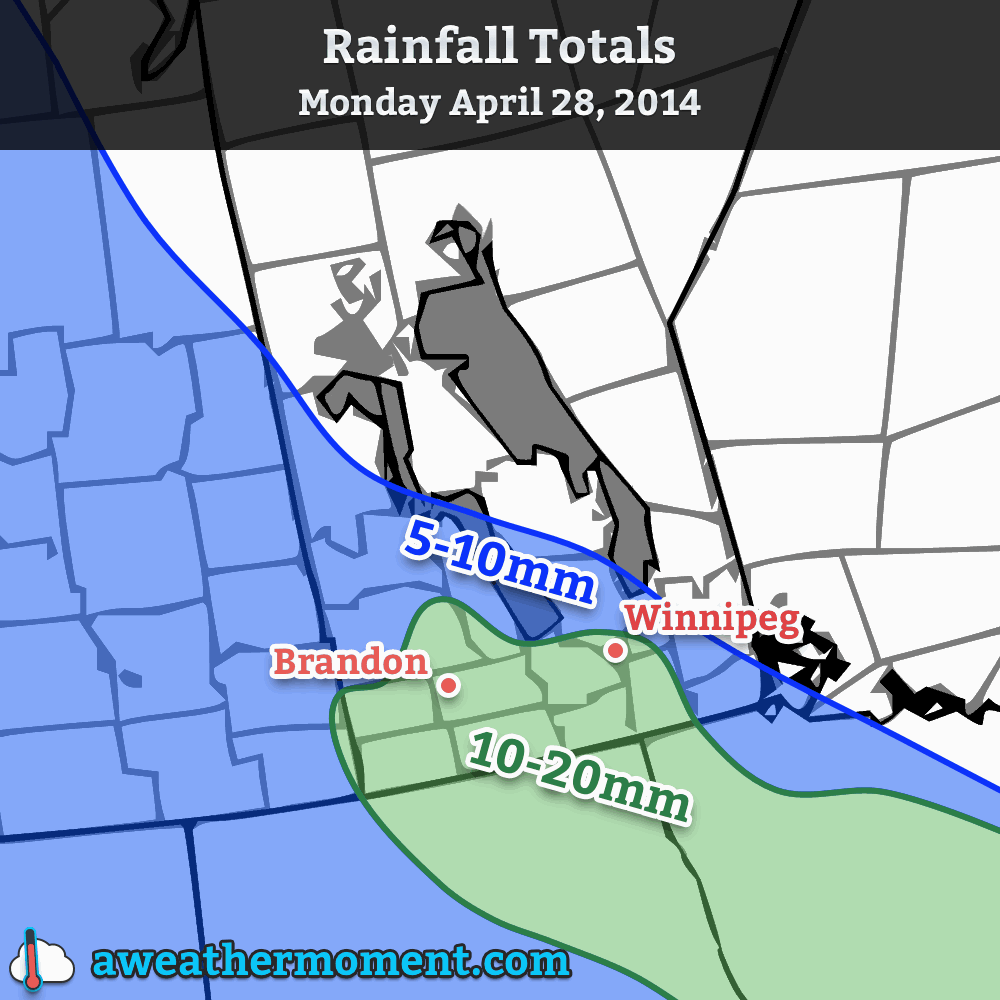
We’re still in for a decent soaking today, though. Periods of rain will persist through the late afternoon or early evening, and in general much of Southern Manitoba will see 10-20mm of rain. Areas further north, towards the Interlake and much of Parkland Manitoba will see in the 5-10mm range, but it does appear that, for the most part, anywhere along and south of the Trans-Canada corridor in SW Manitoba and the Red River Valley will see between 10 and 20mm with the higher amounts closer to the U.S. border. The temperature will sit around 8°C today with breezy winds out of the east at 30km/h with gusts to around 50km/h.
Total rainfall expected today across Southern Mantioba.
Near the border there’s a slight chance of accumulations creeping up towards 25mm (1”) or so, but that will depend on fairly heavy rain and some lingering rainfall a bit longer than it seems like it’s likely too. The rain will taper off by this evening and we’ll see gradual clearing through the evening. The temperature will drop to around 0°C.
Another Short-Lived Break
Tuesday looks to be a cool but pleasant day with a high temperature of around 10°C and mostly sunny skies. Temperatures will drop to around 0°C once again on Tuesday night with increasing cloudiness.
Wednesday brings back the showery weather as another shot of rainfall pushes into Southern Manitoba from east to west on the back-side of the Colorado Low. Accumulations don’t look significant at this point, perhaps 3-5mm on the high end, but it does seem like it will be a cool, dreary day with a high of only around 7°C. The showers should taper off by the evening as we drop to the freezing mark yet again, this time under cloudy skies.
Where’s Summer?
Unfortunately, not here. Below-normal temperatures are once again forecast for the 7-14 day outlook, meaning we’ll likely see high temperatures only in the high single digits or low teens for the next week or two.
But it’s gotta warm up eventually, right? Right? Here’s hoping for a big turnaround in May.