Warm but Unsettled

This week will be warm, but somewhat unsettled. A fairly potent weather system will bring rain and possibly thunderstorms to Southern Manitoba on Tuesday.

image

A low pressure system will bring unsettled weather to Southern Manitoba on Tuesday

Monday

Monday
image
Showers in the morning, then becoming Mainly Sunny.
27°C / 13°C

Monday looks to be the nicest day of the week as we potentially experience our warmest day of the year so far. However, before that happens there may be some shower activity this morning along an approaching warm front. Once this front passes skies will clear and temperatures will begin to rise. High temperatures are expected to be in the mid or upper twenties, with skies becoming mainly sunny by the afternoon.
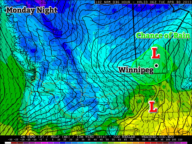
Tuesday

Tuesday
image
Mainly cloudy. Periods of Rain.
20°C / 6°C

Tuesday will be a rather unsettled day in Southern Manitoba. A strong low pressure system will bring rain and perhaps a few non-severe thunderstorms to the southern-most part of the province. The Red River Valley will be in the warm sector of this system in the morning, allowing temperatures to climb up to around the 20C mark before a cold front goes through later in the morning/early in the afternoon. There is a chance we may see some rain or a weak thunderstorm in the morning, but generally speaking the main area of precipitation is expected to pass to our north in the interlake area. Up north of Winnipeg heavy rain will be possible as a stream of moisture is lifted by this system and forms an area of rain. There may be some embedded thunderstorms within the larger area of rain, but they will not be very strong. The Red River Valley may see some wrap around rain on Tuesday night as the area of precipitation over the interlake slumps south. Precipitation amounts from this system will be nearly impossible to predict due to the potential for embedded thunderstorms. In Winnipeg we should see somewhere in the range of 5-10mm, unless a storm goes through in which case we’ll get more. North of Winnipeg upwards of 25mm is possible, but more precise estimates are too difficult to attempt.

Wednesday

Wednesday
image
Mix of Sun and Cloud
20°C / 7°C

Wednesday will see a return to more settled conditions as Tuesday’s system departs. Temperatures will be around the twenty degree mark with a breezy west wind.

Long Range

The rest of the week looks fairly seasonal temperature-wise, with perhaps a chance of light rain on Thursday and/or Friday. A first glance at the long weekend forecast reveals a chance of rain and near seasonal temperatures…but based on past experience, rain on May long weekend is usually a strong possibility…though I probably didn’t need to tell you that!

Return to Cooler Conditions

After a beautiful weekend we’ll unfortunately slip back into well below normal weather this week. This cooler weather will be triggered by the passage of a weather system on Monday.

image

A weather system will bring rain to Southern Manitoba on Monday

Today

image
Increasing clouds. Periods of rain in the afternoon-overnight.
12°C / 6°C

Today will be a fairly normal late April day. Temperatures will be in the low teens with a breezy south wind. Cloud cover will increase during the day, with there being a chance of rain beginning in the afternoon and lasting into the overnight period. This rain will be generated by a fairly strong, complex low pressure system moving through Southern Manitoba and North Dakota today. It is quite difficult to figure out what accumulations might be as the rain may end up quite showery & localized, but my guess would be around 10mm in general with locally higher amounts. The first shot of precipitation will push through in the afternoon as low-level jet over-running a weak warm front slides across the province. This precipitation will be convective in nature, meaning rainfall amounts could be fairly significant (10-20mm) in a short period of time and relatively localized. Those showers will clear out in the evening before a second batch of precipitation arrives with the main low center late overnight. Here in the Red River Valley, that means that we’ll likely see some more shower activity overnight.

Tuesday and Wednesday

Tuesday
image
Chance of Flurries.
6°C / -2°C
Wednesday
image
Mix of sun and cloud
3°C / -3°C

A cold front will swing through tonight, ushering in cooler temperatures for Tuesday. The showers tonight may transition into some flurries on Tuesday morning as this cooler air moves in. Fortunately, these flurries won’t amount to anything, but they will signal a shift back into unpleasant, below-normal conditions. On Tuesday we’ll only see high temperatures in the low single digits with similarly cool values on Wednesday.

Long Range

In the long range there is no sign of a shift towards a more consistently above normal pattern. It looks like we’ll see near normal conditions return around the weekend, with some days being a bit below normal, with others are slightly above normal. There is also no sign of significant precipitation in the long range, which is a good for the flood situation.

Elsewhere in Weather News: December 15th, 2012

Tropical cyclone Evan struck the Samoan Islands on December 13, bringing strong winds and heavy rain to the area.

NASA's Aqua satellite captured this image of Evan as it struck Samoa

NASA’s Aqua satellite captured this image of Evan as it struck Samoa (Source: http://earthobservatory.nasa.gov/NaturalHazards/view.php?id=79989&src=nha)

Evan was a category 1 cyclone when it struck the Samoan Islands region on Thursday, with maximum sustained winds of 144km/h. The storm came onshore near Apia, the capital of Samoa, and the country’s largest city (population 37,708). The cyclone destroyed buildings, ripped up trees, and took down phone, internet, and electricity services across Samoa. In addition, the heavy rain generated by Evan caused widespread flooding. The death toll from Evan is at least 2, with the cyclone being called the worst in many years by local residents.

People walk over a destroyed bridge in Samoa's capital Apia, Friday, Dec. 14, 2012

People walk over a destroyed bridge in Samoa’s capital Apia, Friday, Dec. 14, 2012 (Source: http://www.wunderground.com/blog/JeffMasters/article.html?entrynum=2311)

Evan has taken an unusual track so far, first moving eastward toward Samoa, then making a 180 degree turn over the islands, with its track now taking it westward toward Figi. Evan is currently intensifying, with maximum sustained winds presently at 185km/h. That is high enough to make it a category 3 cyclone on the Saffir-Simpson scale. Current forecasts suggest that the cyclone could approach category 5 status (winds >252km/h) this weekend, before hopefully weakening somewhat prior to affecting Figi. Despite its expected weakening trend ahead of hitting Figi, Evan could become a major disaster for the country, with the country’s leader Commodore Frank Bainimarama’s quoted as saying the following “Fellow Fijians I cannot stress how serious this is, every Fijian will be affected”. Figi is a small country consisting of 332 islands with a population of approximately 850,000.

Weather Roller Coaster

This week will be a bit of a meteorological roller coaster as our temperatures climb up, then fall rapidly back down again.

GEM-Regional predicted rainfall total for Monday

GEM-Regional predicted rainfall total for Monday

Monday looks to be the warmest day of the week with above freezing temperature of 1 or 2C expected in Southern Manitoba. Some light rainfall is expected in south-eastern parts of the province out ahead of a cold front. This may lead to icy conditions on Monday night as temperatures drop below zero behind the front. Winnipeg will be right on the edge of this area of rain, so the city isn’t expected to see more than a millimetre or two of rain at most. In fact most models take the area of rain just south-east of Winnipeg, so the northern part of the Red River Valley may end up with no precipitation at all. Temperatures will plummet on Monday night in the wake of the cold front with values dipping down into the minus double digits by Tuesday morning.

High temperatures will remain down in the minus teens in Southern Manitoba on Wednesday, with most areas in the -11 to -14C range. A weather system emerging from the mountains in Alberta will develop a southerly flow over Manitoba on Tuesday night. As a result, Tuesday night will be characterized by increasing warm air advection, allowing for warmer air to filter into Southern Manitoba during the overnight period. We will continue to experience warming on Wednesday as a stiff south wind continues to bring in warmer air. Unfortunately, the wind will be very strong, making conditions much less comfortable than the temperature alone would indicate. Highs on Wednesday will be in the low to mid minus single digits in Southern Manitoba, but wind chills values will be in the -10 to -15 range due to the strong south wind.

Another cold front will move through on Wednesday night or Thursday, setting up a chilly end to the week. No significant precipitation is currently in the forecast for Southern Manitoba this week as the main storm track remains to our north and west.