Major Winter Storm Moving In

Environment Canada has issued a Winter Storm Warning for this system.

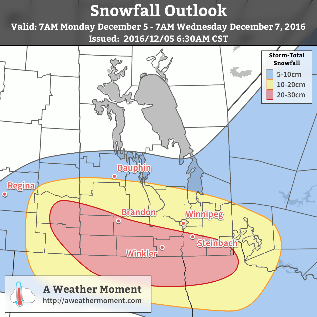
A major winter storm is moving in as you read this article. It will bring the first serious snowfall of the year to the Red River Valley, with heavy blowing snow or even blizzard conditions possible in many areas. You may want to reconsider any travel plans early this week!

A strong low pressure system will bring heavy snow and strong winds to southern Manitoba early this week

Today

Monday
0°C / -2°C
Snow beginning

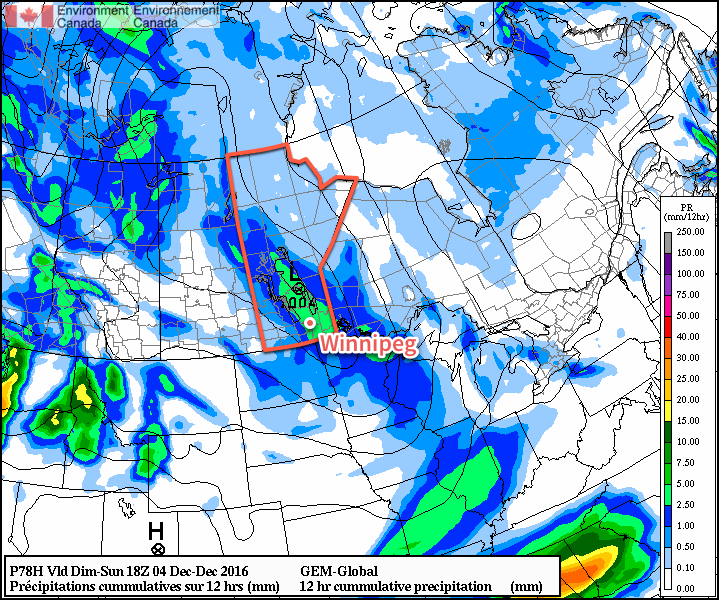
A strong low pressure system will move off the Rocky Mountains and into North Dakota today. It will spread moderate to heavy snowfall into parts of western Manitoba this morning, before snow spreads over the rest of southern Manitoba later in the day. Snowfall will fall for the entire day in most of western Manitoba, with total accumulations of 10-15 cm expected in most areas. Further east, the Red River Valley will see lesser amounts today, with 2-5 cm in the Winnipeg area and more like 5-10 cm near the International border. Local amounts of 15 cm may occur along the International border in south-central Manitoba. Winds will be gusty from the east at 20-30 km/h, producing some blowing and drifting snow.

Tuesday

Tuesday
-2°C / -4°C
Blizzard Developing with Heavy Snow

Conditions will really begin to deteriorate early Tuesday as winds shift to the northwest. Snow will continue to fall as well, with an additional 10-20 cm possible in the Red River Valley on Tuesday. Snow will taper off in southwestern Manitoba, but another 2-5 cm will be possible. The northwesterly winds that develop will be strong at 40 km/h gusting to 60 km/h, with higher values of 50 km/h gusting to 70 km/h in some treeless areas. This will likely result in blizzard conditions over large parts of southern Manitoba, especially south and west of Winnipeg. Those areas that don’t quite meet blizzard criteria will certainly see heavy blowing and drifting snow, with travel becoming difficult or impossible in some areas. Road closures are likely, especially the Trans-Canada Highway west of Winnipeg and Highway 75 south of Winnipeg. Conditions will not improve significantly until early Wednesday.

Expect storm-total snowfall accumulations by Wednesday morning.

Wednesday

Wednesday
-12°C / -20°C
Snow and blizzard ending

Snow should finally taper off on Wednesday morning in all of southern Manitoba, but not until most areas have received significant accumulations of snow. Southwestern Manitoba can expect 15-25 cm, while Winnipeg can expect 10-20 cm. Areas along the International border in south-central Manitoba can expect to receive 20-30 cm. Locally higher amounts may occur where heavier bands of snow persist for a longer period of time. Large snow drifts will be a problem on Wednesday, even once the snow ends. Some rural roads may be impassable due to heavy drifting. Blowing snow will persist on Wednesday, but winds will slowly decrease throughout the day. Temperatures will have dropped noticeably on Wednesday as this system begins to pull down a cold arctic air mass.

Long Range

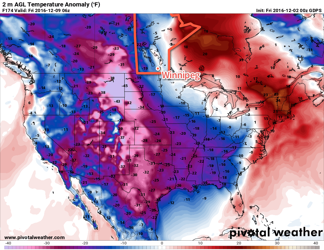
Conditions will finally calm down on Thursday as winds taper off. However, in the wake of this strong low we’ll see a blast of arctic air, with temperatures likely dropping into the minus twenties on Thursday and Friday. This frigid pattern is expected to persist for awhile, so make sure to get out those winter clothes!

Cool With Occasional Snow, Then Temperatures Plunge

The coming days will see a fair amount of cloud and several chances for snow, but temperatures will continue to be slightly above seasonal values. A big change is on tap for next week when a massive blast of Arctic air will plow through much of Canada and the United States, sending temperatures plummeting off a cliff. Time to dig out all the winter clothes.

More of the same. This weekend’s weather will bring little difference from the past several days as low cloud continues to linger through the region. The high temperature today will sit near -2°C with a light winds. Winnipeg & the Red River Valley may see some light isolated snow showers, but no accumulations are expected and for the most part it should just be a mainly cloudy day.

Temperatures will drop to a low near -5°C tonight with a few breaks in the cloud showing up overnight. Winds will pick up out of the south to about 15 km/h by Saturday morning.

Saturday may bring some sunshine through the morning hours, but skies will cloud back up through the afternoon ahead of the next low pressure system moving through. Temperatures should climb to a high near 0°C with continued south winds at 15-20 km/h. Heading into the evening, an area of light snow will spread eastwards into the province as a low pressure system moves into the Interlake from southeastern Saskatchewan. Temperatures will dip to a low near -2°C.

An area of snow will push across Southern Manitoba Saturday night into Sunday morning.

Sunday morning will see the snow gradually tapering off with total amounts close to 2 cm. After that Winnipeg will be left with mostly cloudy skies and the continued chance for some isolated light snow showers. Temperatures will remain steady near -2°C before falling to a low near -6°C on Sunday night under partly cloudy skies.

Long Range

Monday will bring the potential for another snow storm to the region as a low lifts northwards through eastern North Dakota into northern Minnesota. Best guesses at this point are for another 5-10 cm of snow over the Red River Valley and 10-20 cm over southeastern Manitoba. Slight changes in track could result in significant changes to forecast snowfall amounts, though, so we’ll have to keep an eye on it as this system develops through the weekend.

Behind that system, the big story will be the temperature crash over North America:

The GDPS is forecasting a substantial outbreak of Arctic air next week.

Temperatures over a large area are forecast to be 10-20°C below normal as a cold air mass crosses over the pole from Siberia into North America. Here in Manitoba, it appears like we’ll avoid the worst of it with temperatures dipping to seasonal to slightly below seasonal values, but to the west and south winter will be arriving in full force. After a November that saw every single day with above normal temperatures, it will likely be quite a shock to the system!

Winnipeg’s seasonal daytime high is currently -7°C while the seasonal overnight low is -16°C.

Colorado Low Looms

Our first significant Colorado Low in some time will bring a variety of precipitation types to southern Manitoba today. Rain, snow, freezing rain, and ice pellets will be possible.

A variety of precipitation types will be possible in southern Manitoba today. The map shows areas of rain (green), snow (blue), freezing rain (purple), and ice pellets (red).

Today

Monday
2°C / 1°C
Mixed precipitation early, then rain

A powerful Colorado Low will bring a mixed-bag of precipitation to southern Manitoba today. Precipitation will likely start out as freezing rain or ice pellets in portions of the Red River Valley and south-eastern Manitoba this morning, before changing to rain later in the morning. Rainfall amounts of 5-10 mm are expected in most areas, with higher amounts possible near the International border. There may be a bit of snow at times, but little accumulation is expected – and any that were to accumulate will be melted by rain later in the day. However, the story will be different in western Manitoba, where snow will be the dominant precipitation mode for the day. Accumulations of 5-10 cm are likely in most areas by tonight. Winds will be gusty out of the north-east at 30 km/h gusting to 50 km/h, bringing some blowing and drifting to open parts of western Manitoba.

Tuesday

Tuesday
1°C / -1°C
Periods of snow

This Colorado Low will take its time exiting our region, affecting us once again on Tuesday. Unfortunately (for some), rain will change to snow on Tuesday in the Red River Valley and south-eastern Manitoba. Accumulations of 4-8 cm are likely in addition to possibly a couple millimetres of rain or mixed precipitation early in the day. Western Manitoba can expect another 5-10 cm on Tuesday, bringing totals up to 10-20 cm. The model graphic shown below, which considers a wide-range of possible solution, shows a very high probability (>80%) of over 10 mm of total precipitation in most of southern Manitoba. Winds will remain gusty out of the north on Tuesday at 30 km/h gusting to 50 km/h.

Most of southern Manitoba stands a very high chance of receiving over 10 mm of precipitation with this system (NAEFS graphic).

Wednesday

Wednesday
-1°C / -4°C
Mainly cloudy with flurries

The Colorado Low will continue to linger on Wednesday, but snowfall rates will decrease. Flurries are expected throughout the day, but accumulations should be small. Winds will remain breezy from the north at 20-30 km/h.

Long Range

It appears that we’ll see generally seasonal to slightly-above seasonal temperatures as we move into early December. However, longer-range models do hint at a very cold arctic air mass being pulling down from the north about one week into the month. This will have to be monitored, as it would be our first significant bought of below-normal temperatures in quite awhile.

Will Our First Snowfall of the Year Come This Week?

Will our first snowfall of the year come this week? That is the question that meteorologists are trying to answer as a complex weather system potentially brings accumulating snowfall to southern Manitoba tonight.

An inverted trough pattern associated with a strong system to our south may help bring snowfall to southern Manitoba

This Week

Today will start out cloudy and cool with temperatures hovering near the freezing mark. Change is coming, however, as a strong weather system moves off the mountains and begins to produce snow over the northern United States and southern Prairies. This is a complex system, with the strongest part well to our south over the midwestern US. A secondary part of this system will move across the southern Prairies and likely produce accumulating snowfall along part of its track. At this point it appears probable that snow will begin to develop over southern Manitoba on Monday night as moisture and lift begins to push into the region. The question is whether conditions will come together just right to produce significant snow over all of southern Manitoba, or whether the system will only begin to produce significant snow as it pushes into northwestern Ontario.

Weather model simulations generally begin to produce light snow over western Manitoba late on Monday afternoon, before the snowfall intensifies as it moves into the Red River Valley and southeastern Manitoba. This would likely result in 1-4 cm of snow over western Manitoba, 4-8 cm over the Red River Valley, and 5-10 cm over southeastern Manitoba. However, an alternative solution would have only minor snowfall (if any) over western Manitoba and the Red River Valley, with slight accumulations of 2-4 cm over southeastern Manitoba. The former solution is most favoured at this time, with about 5 cm expected in the Winnipeg region, with slightly higher amounts to the east and slightly lower amounts to the west. The most likely outcome may change as the system develops today, therefore you should stay tuned for more details.

A map of the currently favoured snowfall outcome is shown below, showing the probability of at least 5 cm of snow; note that Winnipeg has a 70% chance of receiving at least 5 cm. Some blowing snow is possible, due to southeasterly winds of 30 km/h gusting to 50 km/h today, however blizzard conditions are definitely not expected. Winds will taper off by Tuesday, alleviating any blowing snow that does develop. The first major snowfall of the year is always one of the most challenging as drivers adapt to the changing conditions. Regardless of whether it snows tonight, this is probably a sign that you should get those winter tires on if you haven’t already!

Probability of at least 5 cm of snow according to the NAEFS (ensemble)

Snow will taper off on Tuesday morning, should it materialize in the first place, leaving Tuesday with cloudy and cool conditions. Temperatures will once again sit near the freezing mark under mainly cloudy skies. The odd flurry is possible during the day, but generally quiet weather is expected. Winds will be light from the west.

A quiet weather day is expected on Wednesday as well, with mainly cloudy skies and just a lingering chance of flurries. Temperatures are likely to be around or just above zero. Winds will be northwesterly at 20-30 km/h.

Long Range

The long range outlook will be partly shaped by how much snow falls this week. If we manage to avoid major snow, it is likely that the remainder of November will remain generally warmer than normal. Because a blanket of snow on the ground reflects most of the incoming sunlight, it is more difficult for us to heat up during the day. The longer we avoid snow the longer we’re able to keep that darker, exposed soil which helps to absorb the limited sunlight that we do receive at this time of year. Should we receive significant snow with this upcoming system, we’ll likely see normal conditions through month’s end. Regardless of how much snow falls this week, this November is likely to end up as one of the warmest, if not the warmest, Novembers on record in Winnipeg.